Regional overview
The northern Two Thumb Range is a remote high-country and braided-river sector of Te Kahui Kaupeka Conservation Park, approached mainly from Lake Tekapo by Lilybank Road, Macaulay River and Godley River. The walking character is very different from the Lake Tekapo township walks: long river flats, 4WD easements, shifting braids, hut approaches, open tussock, glacial valleys and unmarked alpine continuations.
DOC describes Macaulay Valley and Godley Valley as routes that can be travelled on foot, mountain bike, horse or 4WD in places, but both require serious judgement around river crossings and weather. The public day-hike inventory is sparse; the sources support one strong long day objective, several hut-to-hut or access-assisted day sections, and one northern access reconnaissance. These are documented here because they are the strongest ways to represent the northern range, not because the area has five easy publication-ready day walks.
The best season is summer to early autumn in low-water conditions. Rain or snowmelt can make Macaulay River, Godley River and side streams difficult or impossible to cross. Cell coverage cannot be relied on, and a personal locator beacon is strongly recommended. Lilybank Road is gravel, road-end access is remote, and no public transport to the trailheads was verified.
Selection rationale
The five selections focus on the two main official northern corridors: Macaulay Valley and Godley Valley. Macaulay Hut provides the clearest long day route; the lower Macaulay and North East Gorge / Two Thumb Stream entries record representative day sections where official sources do not provide full day-hike statistics. Godley River to Red Stag Hut and Red Stag Hut to Godley Hut represent the core Godley route, with access limitations made explicit.
Summary table
| # | Hike | Country | Route type | Distance | Gain | Max elevation | Difficulty | Photo status |
|---|---|---|---|---|---|---|---|---|
| 1 | Macaulay Hut Track | New Zealand | Point-to-point / long out-and-back | 18 km one way; 19.0 km AllTrails point-to-point | 369 m on AllTrails | Not verified | Advanced / hard | Commons image verified |
| 2 | Lower Macaulay Valley day section | New Zealand | Out-and-back | No published day-section distance | Not verified | Not verified | Moderate-hard / candidate | Commons image verified |
| 3 | Godley River to Red Stag Hut | New Zealand | Point-to-point / access-assisted day | 25 km one way | Not published | Not verified | Expert / very long | Commons contextual image verified |
| 4 | Red Stag Hut to Godley Hut | New Zealand | Point-to-point hut-to-hut section | 7 km one way | Not published | Not verified | Expert route | Commons contextual image verified |
| 5 | North East Gorge Stream / Two Thumb Stream northern access reconnaissance | New Zealand | Out-and-back reconnaissance | No published day-route distance | Not verified | Not verified | Candidate only | Commons image verified |
1. Macaulay Hut Track
Snapshot
Itinerary
From the Macaulay road-end area, cross Macaulay River and look for the DOC signs directing travel toward Macaulay Hut. DOC instructs walkers to keep initially to the 4WD track on the public access easement through private farmland. Farther up valley, once in Te Kahui Kaupeka Conservation Park, trampers can choose faster lines on the riverbed where safe. Macaulay Hut sits on the lower Tindill fan. Return by the same valley route or arrange transport/overnight logistics.
Why it is essential
Macaulay Hut is the northern sector’s strongest walking objective: a long river-valley approach into the Two Thumb high country, with direct experience of the braided Macaulay system and the remote northern range.
Equipment
Mountain hiking equipment: sturdy boots, warm and waterproof layers, sun protection, map/GPS, navigation backup, headtorch, emergency shelter, spare food, first aid and a personal locator beacon. Carry river-crossing knowledge and be prepared to wait if the river rises.
Hazards and notes
DOC warns that Macaulay River crossings can be difficult, currents are stronger than they appear, and water levels can rise rapidly because of rain or snowmelt at the headwaters. Braids can shift and soft sinking sand may occur. Dogs must be confined to vehicles through private farmland and until past the conservation-park boundary sign; hut rules also restrict dogs inside. There is no marked track beyond Macaulay Hut.
GPX / KML links
| Source | URL | Format | Licence / terms | Reuse status |
|---|---|---|---|---|
| DOC Macaulay Hut Track | doc.govt.nz | Official route page / source map | DOC website terms; no GPX found | Official route and hazard source |
| AllTrails: Macaulay Hut Track | alltrails.com | Route page / app map | AllTrails terms apply; GPX export terms not verified | Secondary route source only |
| OpenStreetMap search: Macaulay Hut Track | openstreetmap.org | OSM search/map | OSM data is ODbL | Geometry cross-check only |
External links
2. Lower Macaulay Valley Day Section
Snapshot
Itinerary
This day section uses the official Macaulay Hut access at the valley mouth, staying initially on the 4WD easement through private farmland and turning around before the route becomes a full hut approach. The objective is to sample the lower braided valley and return before river crossings, heat, wind or daylight create a commitment problem.
Why it is essential
The lower Macaulay is the most realistic non-hut day outing in the northern sector. It gives walkers the northern valley character without requiring the full 18 km one-way commitment to Macaulay Hut, but it lacks published day-hike statistics and should remain a candidate.
Equipment
Mountain hiking equipment: sturdy footwear, wind/rain layer, warm layer, sun protection, map/GPS, water, food, first aid and a PLB. River-crossing judgement is still required even on a shortened route.
Hazards and notes
Stay on the public access easement through private farmland. Do not attempt river crossings if the water is high, dirty, fast or uncertain. DOC’s Macaulay warnings about rapid rises, soft sand and shifting braids apply to this shorter day section as well.
Photos
| Image | Source | Author | Licence | Reuse notes | Attribution |
|---|---|---|---|---|---|
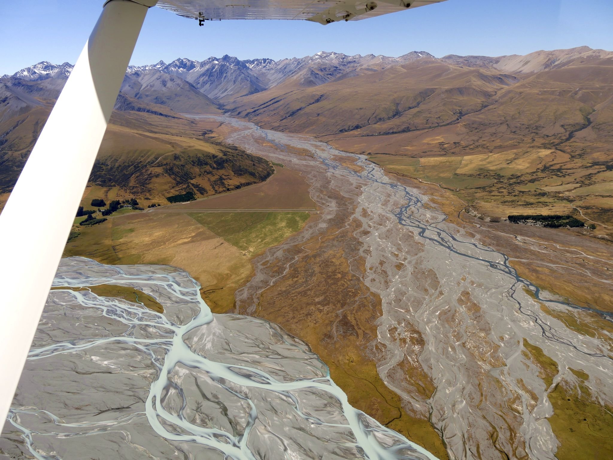
| Macaulay River aerial photo | commons.wikimedia.org | Krzysztof Golik | CC BY-SA 4.0 | Contextual image; commercial reuse and modification allowed with attribution/share-alike | Krzysztof Golik, CC BY-SA 4.0, via Wikimedia Commons |
GPX / KML links
| Source | URL | Format | Licence / terms | Reuse status |
|---|---|---|---|---|
| DOC Macaulay Hut Track | doc.govt.nz | Official route page / source map | DOC website terms; no GPX found | Source-map reference only |
| OpenStreetMap search: Macaulay River road end | openstreetmap.org | OSM search/map | OSM data is ODbL | Geometry cross-check candidate only |
External links
3. Godley River to Red Stag Hut
Snapshot
Itinerary
From the Godley Valley access, keep initially to the 4WD track where it crosses private farmland on a public access easement. The route continues up the broad Godley valley to Red Stag Hut. DOC notes that the hut is very small, so parties should carry a tent if relying on shelter.
Why it is essential
The Godley is the other defining northern valley of Te Kahui Kaupeka Conservation Park. Red Stag Hut is the first major hut objective and gives the catalogue representation of the northern Godley corridor.
Equipment
Full mountain day equipment: boots, warm/windproof and waterproof layers, sun protection, food, water treatment, map/GPS, navigation backup, headtorch, emergency shelter, PLB and spare food. Mountain bikes may reduce travel time where allowed, but route conditions remain remote.
Hazards and notes
DOC currently notes that the Godley River 4WD route has been damaged by river movement above Sibbald Island and that vehicle travel beyond that point is at the user’s risk. Fording braids may be required. No dogs are allowed on the Godley River Route. Braided-river bird nesting areas require care.
GPX / KML links
| Source | URL | Format | Licence / terms | Reuse status |
|---|---|---|---|---|
| DOC Godley River Route | doc.govt.nz | Official route page / source map | DOC website terms; no GPX found | Official route and hazard source |
| OpenStreetMap search: Godley River Route Red Stag Hut | openstreetmap.org | OSM search/map | OSM data is ODbL | Geometry cross-check only |
External links
4. Red Stag Hut to Godley Hut
Snapshot
Itinerary
From Red Stag Hut, follow the generally well-formed track up the Godley valley toward Separation Stream. DOC states that beyond Separation Stream the route to Godley Hut is unmarked and requires experienced trampers to find the way through glacial moraines.
Why it is essential
This is the compact upper-Godley day section: shorter than the long Red Stag approach but more alpine and navigationally serious. It provides access to Godley Hut and the glacial moraine landscape at the head of the valley.
Equipment
Mountain hiking equipment plus remote-route safety: boots, warm/waterproof layers, map and compass/GPS, headtorch, emergency shelter, PLB, spare food and water treatment. Carry enough equipment to stop or retreat if route-finding or river conditions deteriorate.
Hazards and notes
The route beyond Separation Stream is unmarked and crosses glacial moraine terrain. Weather, poor visibility, river crossings and remoteness are the main hazards. This is a hut-to-hut day section, not a simple trailhead day walk.
Photos
| Image | Source | Author | Licence | Reuse notes | Attribution |
|---|---|---|---|---|---|
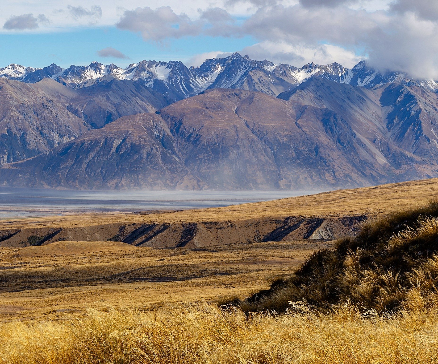
| Two Thumb Range, Canterbury | commons.wikimedia.org | Michal Klajban | CC BY-SA 4.0 | Contextual range image; commercial reuse and modification allowed with attribution/share-alike | Michal Klajban, CC BY-SA 4.0, via Wikimedia Commons |
GPX / KML links
| Source | URL | Format | Licence / terms | Reuse status |
|---|---|---|---|---|
| DOC Godley River Route | doc.govt.nz | Official route page / source map | DOC website terms; no GPX found | Official source-map reference |
| OpenStreetMap search: Godley Hut Separation Stream | openstreetmap.org | OSM search/map | OSM data is ODbL | Geometry cross-check only |
External links
5. North East Gorge Stream / Two Thumb Stream Northern Access Reconnaissance
Snapshot
Itinerary
DOC’s Two Thumb hunting-block information identifies access to the northern end of the Two Thumb Range through public conservation land in the Macaulay Valley via North East Gorge Stream and Two Thumb Stream. No day-walk track notes, distances or normal walking itinerary were found. Any outing should therefore be treated as a map-led reconnaissance from the Macaulay Valley with a conservative turn-around.
Why it is essential
This is the only official source found that specifically describes public access to the northern end of the Two Thumb Range. It is included to capture the northern-range access corridor, but it is not ready for publication as a standard hike.
Equipment
Full remote mountain equipment: boots, warm/waterproof layers, map and compass/GPS, PLB, emergency shelter, headtorch, first aid, spare food and enough water or water-treatment capacity. Parties need backcountry navigation and river-crossing experience.
Hazards and notes
No marked day trail or published route statistics were found. Access, land status, river crossings, hunting activity and conservation rules must be checked before travel. A hunting permit is required for hunting on public conservation land, but this entry is for walking reconnaissance only.
Photos
| Image | Source | Author | Licence | Reuse notes | Attribution |
|---|---|---|---|---|---|
| Macaulay River aerial photo | commons.wikimedia.org | Krzysztof Golik | CC BY-SA 4.0 | Contextual access-valley image; commercial reuse and modification allowed with attribution/share-alike | Krzysztof Golik, CC BY-SA 4.0, via Wikimedia Commons |
GPX / KML links
| Source | URL | Format | Licence / terms | Reuse status |
|---|---|---|---|---|
| DOC Two Thumb hunting block / access information | doc.govt.nz | Official access information / source map | DOC website terms; no GPX found | Access reference only; not a walking route file |
| OpenStreetMap search: North East Gorge Stream Two Thumb Stream | openstreetmap.org | OSM search/map | OSM data is ODbL | Geometry cross-check candidate only |
External links
External links
| Source | URL |
|---|---|
| DOC — Te Kahui Kaupeka Conservation Park brochure (PDF) | doc.govt.nz |
| DOC — Macaulay Hut Track | doc.govt.nz |
| DOC — Godley River Route | doc.govt.nz |
| DOC — Two Thumb hunting block / access information | doc.govt.nz |
| AllTrails — Macaulay Hut Track | alltrails.com |