Regional overview
The Lake Tekapo sector is the western gateway to the Two Thumb Range and Te Kahui Kaupeka Conservation Park. It combines short Mackenzie Basin viewpoint walks around Lake Tekapo with longer high-country approaches toward Roundhill, Richmond Trail, Coal River and Camp Stream Hut. The landscape is open tussock, glacial terraces, turquoise lake margins, braided rivers, dry high-country slopes and the first alpine approaches toward Stag Saddle.
The main walking bases are Lake Tekapo township, Tekapo Springs, Godley Peaks Road, Lilybank Road, Roundhill Ski Area road and the Coal River access. Shorter walks near the village are generally straightforward in settled weather, while Richmond Trail and Camp Stream Hut enter exposed high-country terrain where navigation, wind, heat, cold and private-land access rules matter.
The best general season is late spring to autumn. Summer sun and wind exposure are important on open tracks, while winter and spring can bring snow, avalanche concerns on higher routes, icy road access and ski-area traffic. DOC notes that Lake Tekapo has daily bus services to Christchurch and Queenstown, but trailheads beyond town normally require private transport, shuttle, bicycle or arranged pick-up.
Selection rationale
The five hikes represent the sector’s natural progression: the iconic Mount John viewpoint, two accessible lake/township walks, the terrace traverse of Richmond Trail, and the harder Te Araroa approach to Camp Stream Hut at the edge of the Two Thumb alpine backcountry.
Summary table
| # | Hike | Country | Route type | Distance | Gain | Max elevation | Difficulty |
|---|---|---|---|---|---|---|---|
| 1 | Mount John Walkway | New Zealand | Loop | 8.4-8.9 km | 401 m on AllTrails | Not officially verified | Moderate |
| 2 | Cowans Hill Walkway | New Zealand | Out-and-back / town link | 3.2 km one way by DOC; 6.0 km return on AllTrails | 128 m on AllTrails | Not officially verified | Easy |
| 3 | Lake Tekapo Peninsula Walkway | New Zealand | Loop | 4.0-5.3 km depending on source | 123 m on AllTrails | Not officially verified | Easy |
| 4 | Richmond Trail | New Zealand | Point-to-point | 13 km | Not published | Not verified | Moderate-hard |
| 5 | Camp Stream Hut Track from Coal River | New Zealand | Out-and-back | 18 km return by DOC one-way distance; AllTrails 17.1 km return | 715 m on AllTrails | Not verified | Advanced / hard |
1. Mount John Walkway
Snapshot
Itinerary
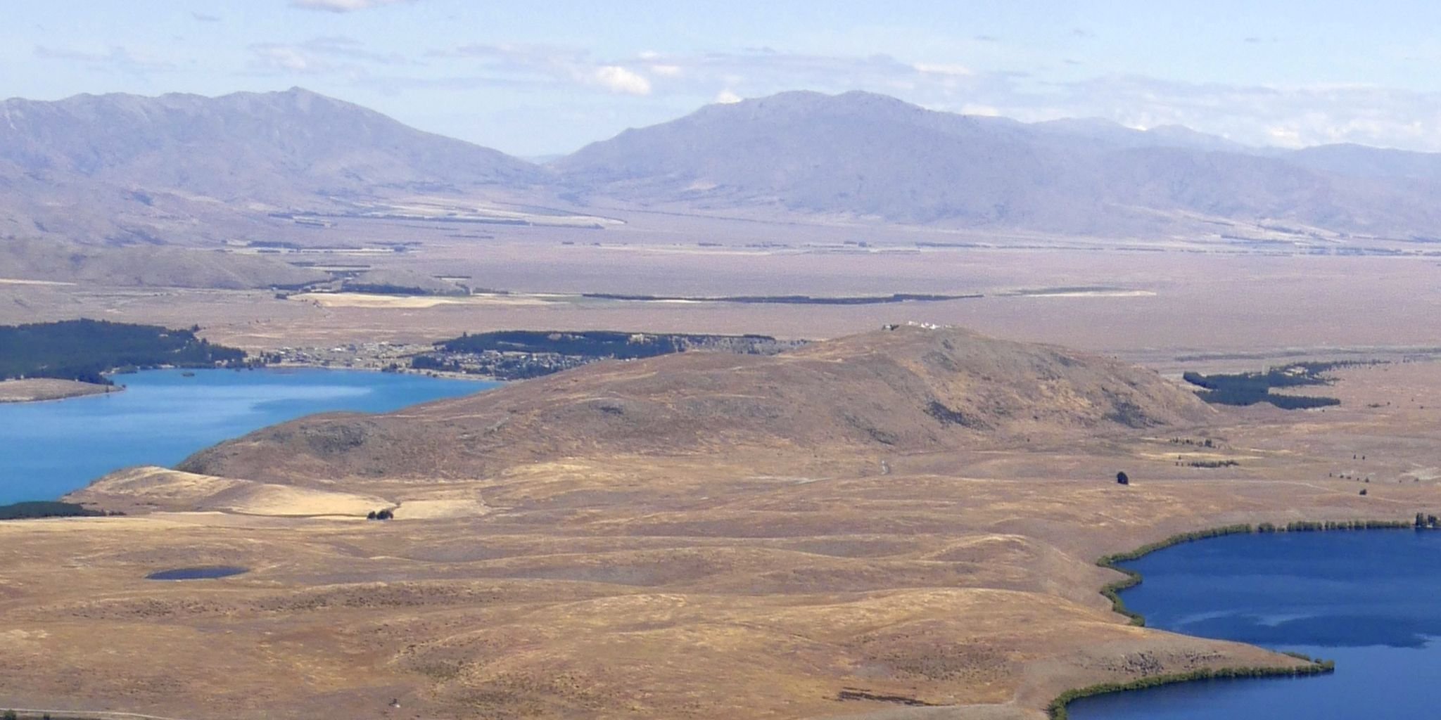
From Tekapo Springs, the direct summit track climbs through larch forest to Mount John and the observatory area. The route then follows the open summit circuit and returns by the lakeshore walkway, giving views over Lake Tekapo, the Mackenzie Basin and the surrounding ranges.
Why it is essential
Mount John is the signature short summit above Lake Tekapo and the most accessible overview of the lake, basin and Two Thumb Range skyline. It is also tied to the Mount John Observatory and the Aoraki Mackenzie International Dark Sky Reserve.
Equipment
Standard hiking equipment: sturdy shoes, weatherproof layer, warm layer, water, food, sun protection and map/GPS. Carry a windproof layer because the summit is exposed.
Hazards and notes
The route crosses private land and walkers must keep to the track. DOC notes that dogs are not allowed. The walkway has an annual closure from 6 pm on 24 December until 6 pm on 26 December for pest control. The summit and lakeshore sections are exposed to sun, wind and winter ice.
GPX / KML links
| Source | URL | Format / access | Reuse status |
|---|---|---|---|
| DOC Mackenzie-Waitaki walks PDF | doc.govt.nz | Official PDF route notes / source map | DOC website/PDF terms; no GPX found; official source-map reference only |
| AllTrails: Mount John Walkway | alltrails.com | Route page / app map | AllTrails terms apply; secondary route source only |
External links
2. Cowans Hill Walkway
Snapshot
Itinerary
The walkway follows the Tekapo River corridor from near the SH8 bridge, then climbs through open ground and plantation margins on Cowans Hill before descending or linking back toward the highway/township access points. The high point gives a compact view across Lake Tekapo, Mount John and the surrounding basin.
Why it is essential
Cowans Hill is the best short township walk that still gives a raised landscape view. It balances the higher Mount John route with an easier basin-and-river walk accessible directly from Lake Tekapo.
Equipment
Standard hiking equipment: walking shoes, water, sun protection and a windproof or rain layer. Map/GPS is useful because town-link variants can be confusing.
Hazards and notes
Dogs are allowed on lead where local signage permits. Sections near roads require care. The track is exposed to sun and wind and can be muddy or icy in poor weather.
GPX / KML links
| Source | URL | Format / access | Reuse status |
|---|---|---|---|
| DOC Mackenzie-Waitaki walks PDF | doc.govt.nz | Official PDF route notes / source map | DOC website/PDF terms; no GPX found; official source-map reference only |
| AllTrails: Cowans Hill Walkway | alltrails.com | Route page / app map | AllTrails terms apply; secondary route source only |
External links
3. Lake Tekapo Peninsula Walkway
Snapshot
Itinerary
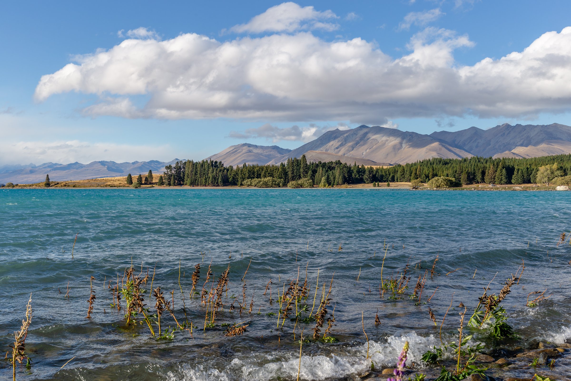
From the Godley Peaks Road car park, cross the stile and follow the marked circuit around the Lake Tekapo peninsula. The walk uses open lakeshore and low hill terrain, passing views toward Motuariki Island, the eastern shore of Lake Tekapo and the surrounding mountain skyline.
Why it is essential
This is the sector’s best lake-margin circuit: lower and easier than Mount John, quieter than the township tracks, and strongly representative of Lake Tekapo’s open high-country shore.
Equipment
Standard hiking equipment: walking shoes, water, sun protection, windproof/rain layer and map/GPS. Carry enough water in hot weather because the route is exposed.
Hazards and notes
DOC notes that the Peninsula Walkway is a community initiative and is not managed by DOC. Dogs are not allowed. Stay on the marked route, respect farmland access and watch for wind exposure near the lake.
GPX / KML links
| Source | URL | Format / access | Reuse status |
|---|---|---|---|
| DOC Mackenzie-Waitaki walks PDF | doc.govt.nz | Official PDF route notes / source map | DOC website/PDF terms; no GPX found; source-map reference only |
| AllTrails: Lake Tekapo Peninsula Walkway | alltrails.com | Route page / app map | AllTrails terms apply; secondary route source only |
External links
4. Richmond Trail
Snapshot
Itinerary
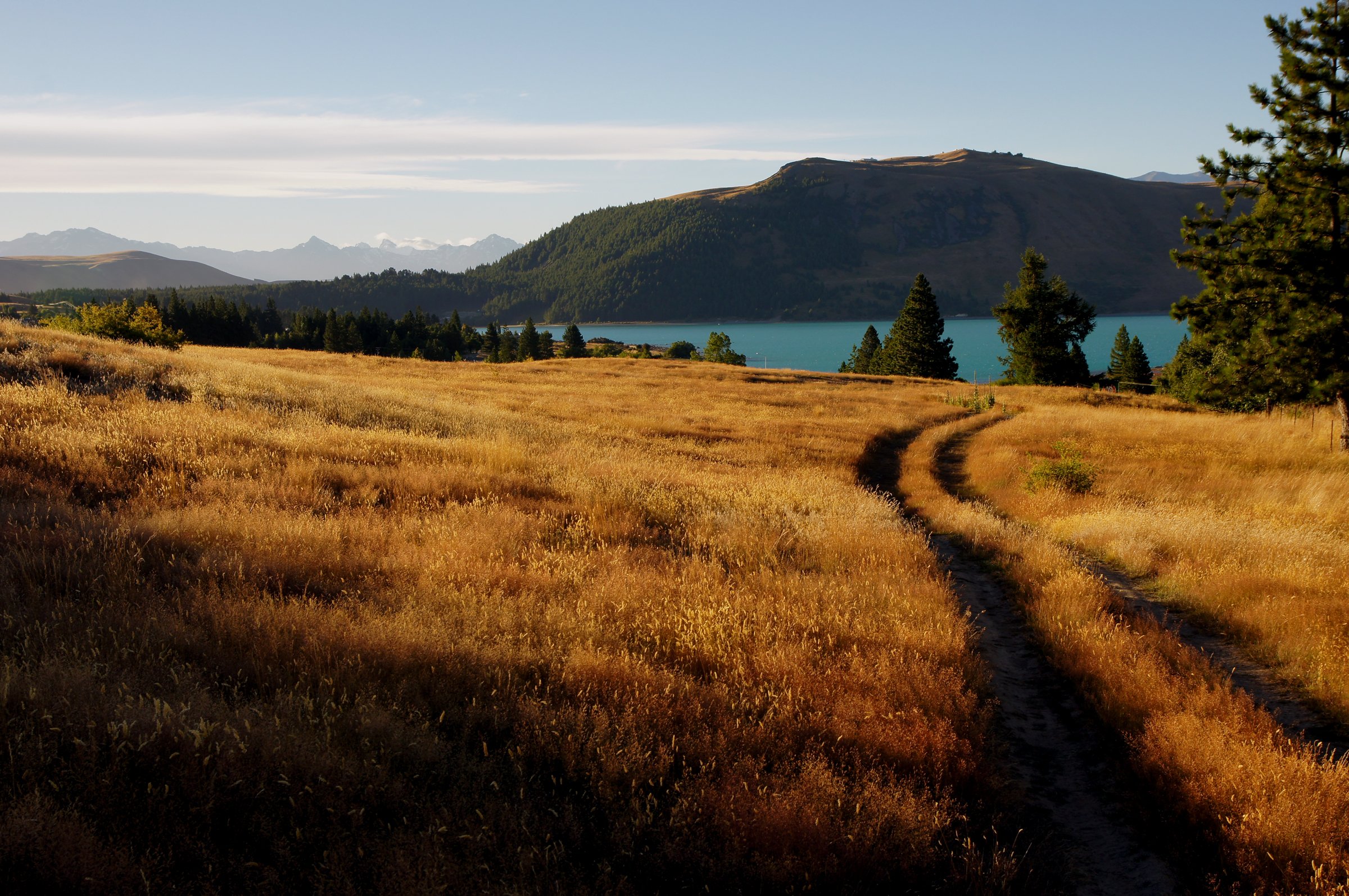
From the Roundhill Ski Area access-road area, the route follows the marked Richmond Trail across glacial terrace country above Lake Tekapo. It descends back toward Lilybank Road near Boundary Stream. DOC notes that the route crosses private land and a pastoral lease, and walkers must keep to the marked track.
Why it is essential
Richmond Trail is the Lake Tekapo sector’s classic terrace traverse: a long open walk above the lake with direct visual connection to the Two Thumb Range and the eastern shore high country.
Equipment
Mountain hiking equipment: sturdy footwear, warm and windproof layers, waterproof shell, sun protection, map/GPS, navigation backup, food and plenty of water. A headtorch is prudent if transport logistics could delay the start.
Hazards and notes
No dogs, bikes or horses are allowed. Stay on the marked track through private land. The route is exposed to wind, sun and poor visibility, and it requires transport planning because it starts and finishes in different places.
GPX / KML links
| Source | URL | Format / access | Reuse status |
|---|---|---|---|
| DOC Mackenzie-Waitaki walks PDF | doc.govt.nz | Official PDF route notes / source map | DOC website/PDF terms; no GPX found; official source-map reference only |
| DOC Te Kahui Kaupeka Conservation Park brochure | doc.govt.nz | Official PDF map and route notes | DOC website/PDF terms; no GPX found; official source-map reference only |
| Te Araroa Canterbury GPX | teararoa.g2digital.co.nz | GPX | Te Araroa official 2025-26 GIS data; reuse/attribution terms need checking |
| Te Araroa Canterbury KMZ | teararoa.g2digital.co.nz | KMZ | Te Araroa official 2025-26 GIS data; reuse/attribution terms need checking |
External links
- DOC — Mackenzie-Waitaki walks (PDF)
- DOC — Te Kahui Kaupeka Conservation Park brochure (PDF)
- Te Araroa — Trail maps
5. Camp Stream Hut Track from Coal River
Snapshot
Itinerary
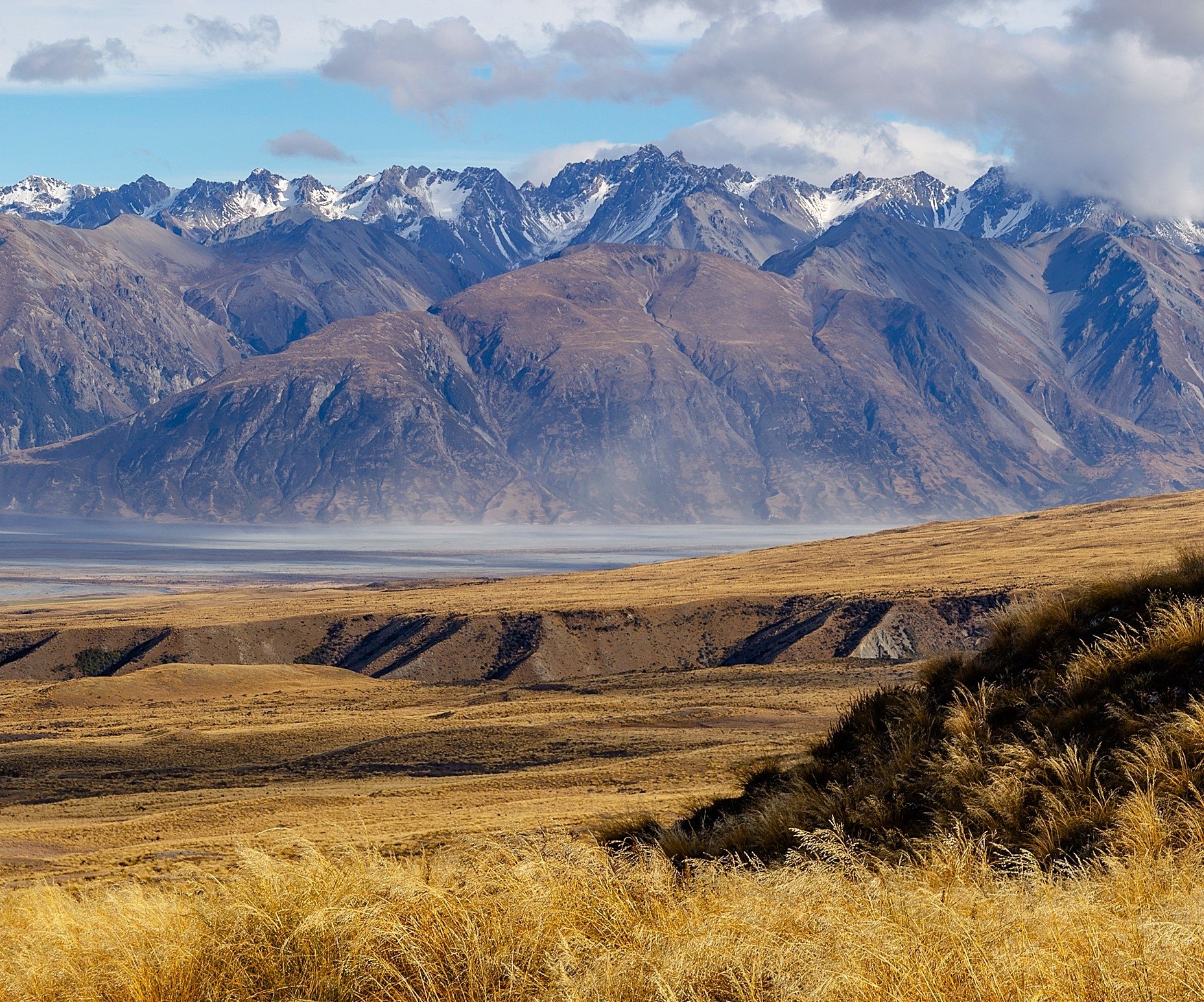
From Lilybank Road, turn onto Roundhill Snow Area road and continue to the formed car park. The route climbs from the skifield-road area, crosses through Coal River country and follows the poled Te Araroa line toward Camp Stream Hut. The hut is a six-bunk Mackenzie Alpine Trust hut. Return by the same route unless linking into the longer Stag Saddle / Bush Stream route.
Why it is essential
Camp Stream Hut is the Lake Tekapo sector’s gateway to the Two Thumb alpine route and Stag Saddle. It adds a harder hut objective to the lower lake walks and marks the transition from Mackenzie Basin day walking into backcountry tramping.
Equipment
Mountain hiking equipment: sturdy boots, warm/windproof layers, waterproof shell, sun protection, map/GPS, navigation backup, headtorch, food, water and emergency shelter. Carry a PLB for remote travel.
Hazards and notes
The route is exposed to alpine weather and river/stream conditions. Winter travel may involve snow and ski-touring conditions. DOC currently lists dogs allowed under control on the Camp Stream Hut Track page, while wider park and private-land restrictions vary by access route; check current signs and DOC rules before taking a dog.
GPX / KML links
| Source | URL | Format / access | Reuse status |
|---|---|---|---|
| DOC Camp Stream Hut Track | doc.govt.nz | Official route page / source map | DOC website terms; no GPX found; official route source |
| Te Araroa Canterbury GPX | teararoa.g2digital.co.nz | GPX | Te Araroa official 2025-26 GIS data; reuse/attribution terms need checking |
| Te Araroa Canterbury KMZ | teararoa.g2digital.co.nz | KMZ | Te Araroa official 2025-26 GIS data; reuse/attribution terms need checking |
| AllTrails: Camp Stream Hut | alltrails.com | Route page / app map | AllTrails terms apply; secondary route source only |
External links
External links
| Source | URL |
|---|---|
| DOC — Mackenzie-Waitaki walks (PDF) | doc.govt.nz |
| DOC — Te Kahui Kaupeka Conservation Park brochure (PDF) | doc.govt.nz |
| DOC — Camp Stream Hut Track | doc.govt.nz |
| Te Araroa — Trail maps | teararoa.org.nz |
| Te Araroa Canterbury GPX | teararoa.g2digital.co.nz |
| Te Araroa Canterbury KMZ | teararoa.g2digital.co.nz |
| AllTrails — Mount John Walkway | alltrails.com |
| AllTrails — Cowans Hill Walkway | alltrails.com |
| AllTrails — Lake Tekapo Peninsula Walkway | alltrails.com |
| AllTrails — Camp Stream Hut | alltrails.com |


