Regional overview
Korowai/Torlesse Tussocklands Conservation Park is a 21,000 ha block of inland Canterbury high country on New Zealand’s South Island, draped across the eastern flank of the Torlesse and Big Ben ranges between the Waimakariri River to the north and the Rakaia River to the south. Opened by Minister of Conservation Sandra Lee on 2 November 2001, it was the country’s first conservation park dedicated to tussock grasslands and protects the eastern limit of mid-ribbed snow tussock (slim-leaved snow tussock / wī kura). The dual name reflects long-standing significance to Ngāi Tahu — whose ancestor Tanetiki is connected with the area — alongside surveyor Charles Obins Torlesse, the first European to walk the range, in January 1849.
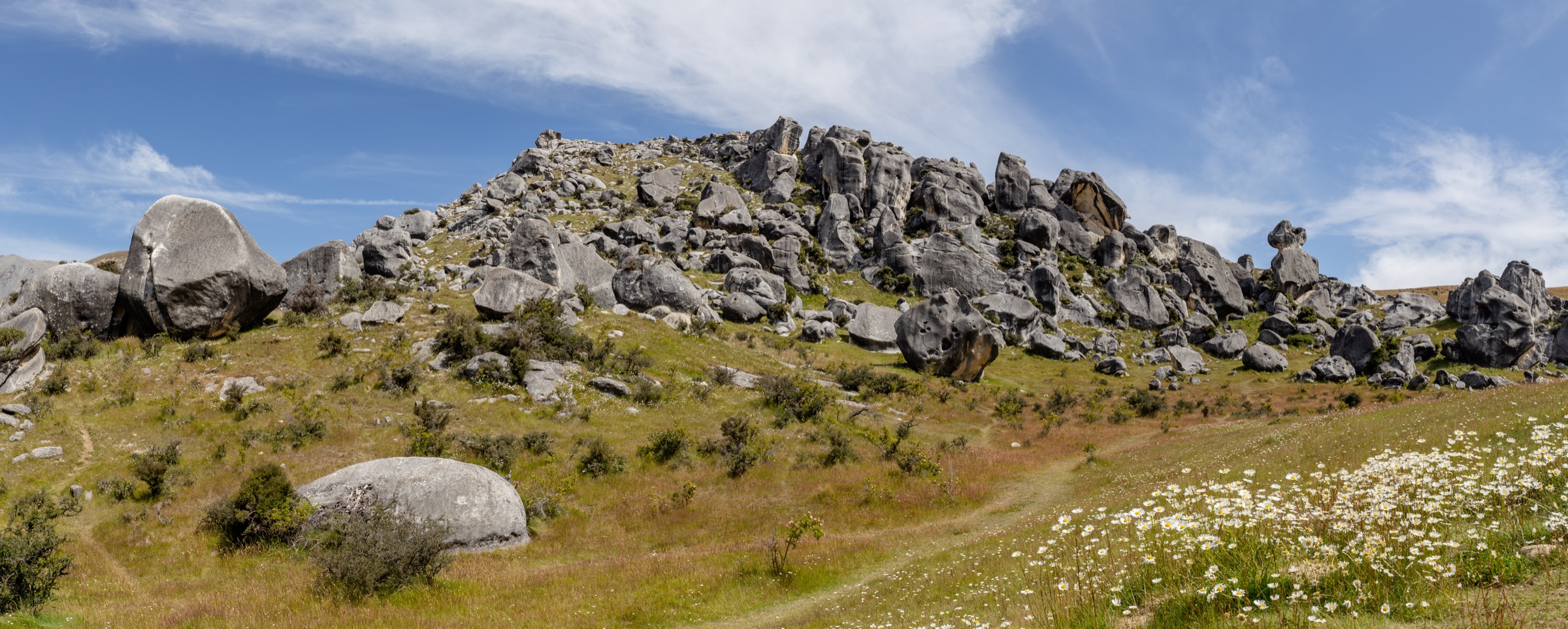
The landscape is sharp, dry and steep: rapidly weathering greywacke ridges, broad scree fans, sub-alpine shrubland and tussock grassland, with small remnant pockets of mountain beech (tawhairauriki) tucked into sheltered gullies such as Thirteen Mile Bush. Higher summits and ridge crests are exposed and waterless; the lower valleys hold the only reliable water and the only beech forest. Bird life includes kea, New Zealand falcon (kārearea), pipit (pīhoihoi), tomtit (miromiro), rifleman (titipounamu) and brown creeper (pīpipi), and the tussock and scree slopes hum with native invertebrates — Maoricicada cicadas, stone wētā and native grasshoppers.
The park is unusually accessible. State Highway 73 from Christchurch to Arthur’s Pass forms its northern boundary, and the four main public access points — Porters Pass lay-by, Starvation Gully on SH73 between Porters Pass and Lake Lyndon, Benmore Road via Thirteen Mile Bush, and Lake Coleridge Road via the Dry Acheron Track — all sit within a 60–90 minute drive of Christchurch. Several other approaches (Kowai River, Brooksdale Station and the upper Porter Heights ski road) cross working high-country stations and require advance landholder permission. The New Zealand Defence Force trains regularly within the park boundaries; public access is unaffected during exercises.
The formal track inventory is sparse. DOC distinguishes between “tracks” (marked and benched) and “routes” (unmarked, poled or trodden lines for fit, experienced parties). Inside the park, only the Trig M, the Coach Stream and the Dry Acheron Track are formally signed; everything else is an unmarked ridge route. Summer (late November to April) is the standard hiking season, though wasps reach high numbers between January and April. Winter brings snow, lingering ice on shaded slopes and avalanche risk on the steeper Torlesse faces; nor’wester gales can be ferocious on the ridge tops at any time of year.
This catalogue covers the day-hikes wholly inside the conservation park. Summit routes targeting Mount Torlesse, Castle Hill Peak and Foggy Peak belong in the companion Mount Torlesse Area article; the limestone-tor and short interpretive walks of the Castle Hill basin belong in the companion Castle Hill Basin article. The Trig M corridor walked here sits inside this park’s signed track network and is the standard introduction to it.
Selection rationale
After excluding the Mount Torlesse and Castle Hill Basin objectives, the park has only a handful of distinct, genuinely essential day-hikes. The five below span the three geographically separated access faces of the park (Porters Pass to the north-east, Benmore Station to the south-west, Lake Coleridge to the south) and the three main vegetation zones (tussock ridge, beech forest valley, sub-alpine scree). The two Trig M variants are presented as distinct hikes — the Starvation Gully out-and-back is the standard introductory ridge walk, while the Coach Stream Route is a separate historical-heritage line up the 1858–59 Cobb & Co. coach road that joins Trig M only near the summit. Padding the list with summit duplicates or non-essential mountain bike spurs would misrepresent the park’s actual walking inventory.
Summary table
| # | Hike | Country | Route type | Distance | Gain | Max elevation | Difficulty |
|---|---|---|---|---|---|---|---|
| 1 | Trig M Route (from Starvation Gully) | New Zealand | Out-and-back | 6.2 km | ~430 m | 1,251 m | DOC expert route; moderate for fit walkers |
| 2 | Coach Stream Route to Trig M | New Zealand | Point-to-point or out-and-back | 7.3–8.4 km | ~700 m | 1,251 m | DOC expert route; moderate in fair weather |
| 3 | Annavale Track to Sugarloaf (+ Benmore Hut loop) | New Zealand | Out-and-back or 16.8 km loop | 5–16.8 km | 600–650 m | ~1,203 m | Easy–Moderate |
| 4 | Dry Acheron Track to Big Ben summit | New Zealand | Out-and-back | 19.6 km | 1,009 m | 1,416 m | Moderate–Difficult |
| 5 | Dry Acheron Track lower section (covenant walk) | New Zealand | Out-and-back | 16 km | ~250 m | ~700 m | Advanced tramping track |
1. Trig M Route (from Starvation Gully)
Snapshot
Itinerary
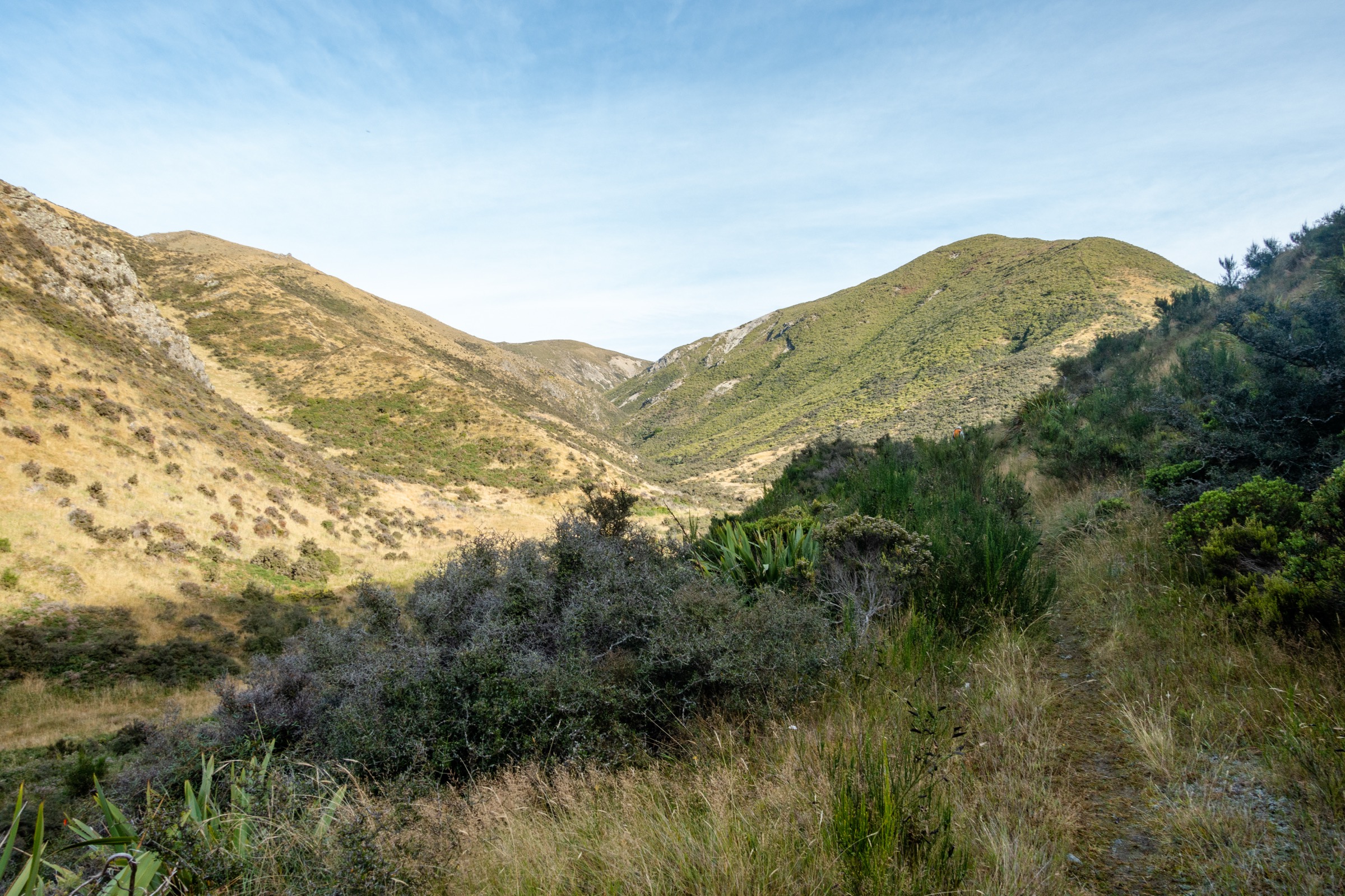
The route begins at the small Starvation Gully car park on the south side of SH73, roughly halfway between the top of Porters Pass and Lake Lyndon (NZTopo50 map BW21 Springfield). An old farm vehicle track climbs the open hillside through sub-alpine shrubland, then traverses tussock ridges to the trig point. Navigation along the well-worn 4WD line is straightforward in fair weather. The summit is a flat tussock high point marked by an old survey trig, with panoramic views: north to the Craigieburn Range across the Waimakariri Basin, east to the Canterbury Plains and on clear days as far as Christchurch and the sea, south to Lake Coleridge and the Big Ben Range, and west to the Southern Alps. Return is by the same route. A side trip from Trig M follows the ridgeline 3–4 hours return north-west to Rabbit Hill (1,480 m), crossing a wet tussock basin with springs underfoot.
Why it is essential
Trig M is the only formally marked walking destination wholly inside Korowai/Torlesse Tussocklands Park. It delivers the park’s defining experience — tussock ridge crests with 360-degree high-country views — at a moderate cost in distance and ascent, and is the standard introduction to the park for visitors with a single day from Christchurch.
Equipment
Standard hiking equipment plus an extra warm layer and windproof shell — the ridge is fully exposed. No drinkable water on route; carry all liquids. Sun protection is essential at altitude. Trekking poles are useful on the descent. Microspikes are useful in spring if snow remains on the upper section.
Hazards and notes
The route is unmarked above the 4WD line and exposed to nor’wester gales; low cloud can obscure the open tops and make navigation back to the correct ridge spur harder. Winter snow and ice make the descent slick. The summit lies on conservation land but the lower section crosses pastoral lease — dogs are permitted but must be kept under control. Wasps are abundant January to April. The car park is small and fills quickly on summer weekends.
Verification status
Route verified against the DOC Trig M Route page; Wikimedia photos verified CC BY-SA 4.0. No licence-clear GPX has been confirmed for redistribution — see the references below for reading material and OpenStreetMap for a redrawable trace.
GPX / KML links
| Source | URL |
|---|---|
| DOC — Trig M Route | doc.govt.nz |
| AllTrails — Trig M Track | alltrails.com |
| OpenStreetMap — Trig M area | openstreetmap.org |
2. Coach Stream Route to Trig M
Snapshot
Itinerary
The route follows the lower section of the original Cobb & Co. coach road built in 1858–59 over Porters Pass — the first European wheeled route to the West Coast. From the car park at the sharp bend at the bottom of Porters Pass, a well-graded packtrail climbs the true left of Coach Stream past stands of mountain beech, then zigzags up the southern hillside out of the gully and gains a tussock shoulder at about 1,000 m. Striking rock tors stand on the open ridge here. The route circumnavigates the head of Coach Stream through a beech copse and joins the Trig M Route at approximately 1,150 m. Continuing north along the ridgeline reaches Trig M at 1,251 m. Descend the Trig M 4WD line to Starvation Gully, or return the same way.
Why it is essential
The Coach Stream line is the park’s only true historical-heritage hike: it follows the surviving formation of the 1858–59 Porters Pass road, the original gold-rush coach route through the Southern Alps foothills. It pairs naturally with Trig M to form a one-way traverse that captures both the historical and the high-country panoramic experience in a single day.
Equipment
Standard hiking equipment plus an extra warm layer, windproof shell, trekking poles and a headtorch for short autumn days. No reliable water above the lower Coach Stream. Sun protection. Two vehicles are strongly recommended for the traverse.
Hazards and notes
DOC notes that no dogs are allowed on the Coach Stream Route because the lower section crosses private farmland under easement. The historic packtrail is well worn but unmarked; in low cloud the upper section above the beech can be confusing. Winter snow obscures the route and avalanche risk increases on the steeper southern sidles. The lower stream crossings may run high after heavy rain.
Verification status
Route verified against the DOC Coach Stream Route page and the Wilderness Magazine 2013 trip report; Wikimedia photos verified CC BY-SA 4.0. The Wilderness Magazine GPX is downloadable but its reuse terms are not explicit — treat as reference geometry.
GPX / KML links
| Source | URL |
|---|---|
| DOC — Coach Stream Route | doc.govt.nz |
| Wilderness Magazine — Cruising the old coach road | wildernessmag.co.nz |
| AllTrails — Trig M via Coach Stream | alltrails.com |
| OpenStreetMap — Coach Stream packtrail | openstreetmap.org |
3. Annavale Track to Sugarloaf (with optional Benmore Hut loop)

Snapshot
Itinerary
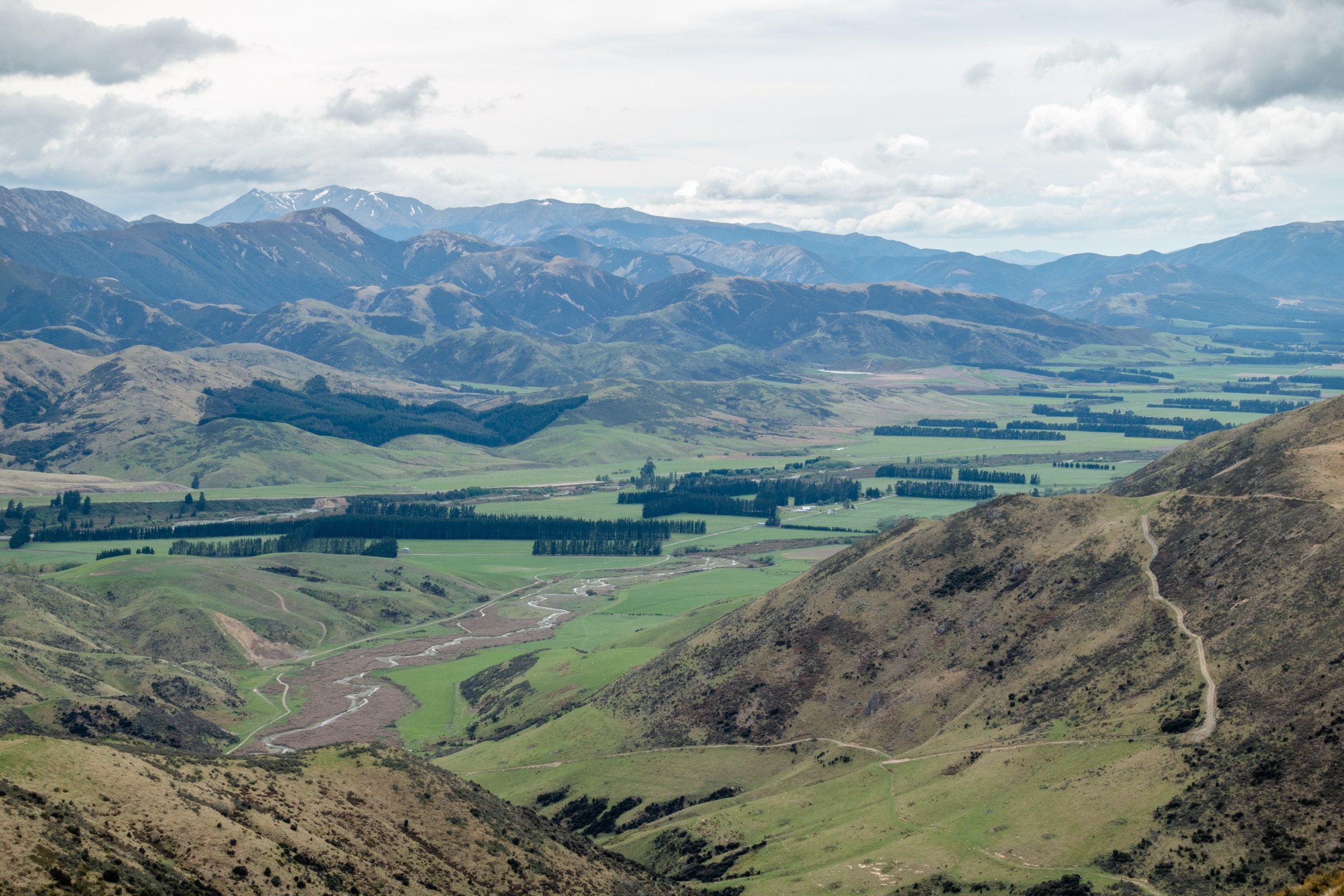
From the Benmore Station car park follow the marked Benmore (Thirteen Mile Bush) Track along the 4WD line beside Thirteen Mile Bush Stream. The track crosses the easement through Benmore Station; leave gates as found. At about 2.3 km the track fords the stream — expect wet feet in normal flow. Half a kilometre on, a signposted junction offers two options: continue straight on the Benmore Track 3.2 km to Benmore Hut, or turn left up the Annavale Track. The Annavale Track crosses a fence, leaves the stream and follows a 4WD line onto open tussock-covered hillside, climbing roughly 600 m in 4 km to the summit ridge of the Russell Range. After about two hours the Annavale–Benmore Link Track junction is reached. Continuing the climb to Sugarloaf (Pt 1203) for a 60-minute return side trip rewards with a 360-degree view of the Torlesse Range, the Big Ben Range, Thirteen Mile Bush and the Canterbury Plains. To close the loop, return to the Link Track and drop west through tussock then beech into the basin holding Benmore Hut (a free, basic three-bunk hut owned by the New Zealand Deerstalkers Association). From the hut the Benmore Track follows the bush-line back down Thirteen Mile Bush Stream to the car park.
Why it is essential
The Annavale Track is the park’s only accessible high-foothill ridge route on the south-western flank and the only one in this catalogue that legitimately suits an easy-moderate day-walker. It is also the only route here that combines a beech forest valley, a sub-alpine ridge summit and a tramper’s hut in one circuit. The track formation is recent (post-2008 Walking Access Act easement) and offers reliable, signposted public access through working high-country station land.
Equipment
Standard hiking equipment plus mountain hiking additions for the ridge: warm layer, windproof shell, trekking poles useful, sturdy boots (stream crossing on the lower Benmore Track is wet). Headtorch for the full loop in spring or autumn. No dogs on the Annavale section (easement crosses private land).
Hazards and notes
The Thirteen Mile Bush Stream crossing can become impassable in flood. The summit ridge is exposed to the nor’wester. Leave gates as found and stay on the marked easement through farmland. New Zealand Defence Force training exercises occasionally take place on adjoining tussock; public access is unaffected.
Verification status
Verified — track statistics, photo licences and source authority (Herenga ā Nuku Aotearoa, Wilderness Magazine) all confirmed. Photo of the Sugarloaf summit on the Annavale Circuit is CC BY-SA 4.0.
GPX / KML links
| Source | URL |
|---|---|
| Herenga ā Nuku — Annavale Track | herengaanuku.govt.nz |
| Herenga ā Nuku — Annavale Track PDF | herengaanuku.govt.nz |
| Wilderness Magazine — Benmore Hut via Annavale Track | wildernessmag.co.nz |
| OpenStreetMap — Annavale and Benmore tracks | openstreetmap.org |
4. Dry Acheron Track to Big Ben summit
Snapshot
Itinerary
The Dry Acheron Track is the first walkway established under the 2008 Walking Access Act. It crosses both Dry Acheron Station and Big Ben Station — about 4,600 ha of combined freehold and pastoral lease — via legal easement. From the car park on Coleridge Road follow DOC markers across farmland and three stiles for about 2 km, then drop into the Dry Acheron Stream bed itself. The route now follows the stream upward through a series of small gorges, with DOC markers intermittent and the line crossing back and forth between banks. After ~5 km the outlets of two small lakes form the stream; cross a fence at the stile, walk the true left bank past willows along a faint 4WD line, then return to the stream bed. Side trips lead to the Clay Gully covenant (10 minutes off-track) and the Conical Knoll covenant (30 minutes off the Big Ben Route junction); both are botanical reserves of regenerating native scrub.
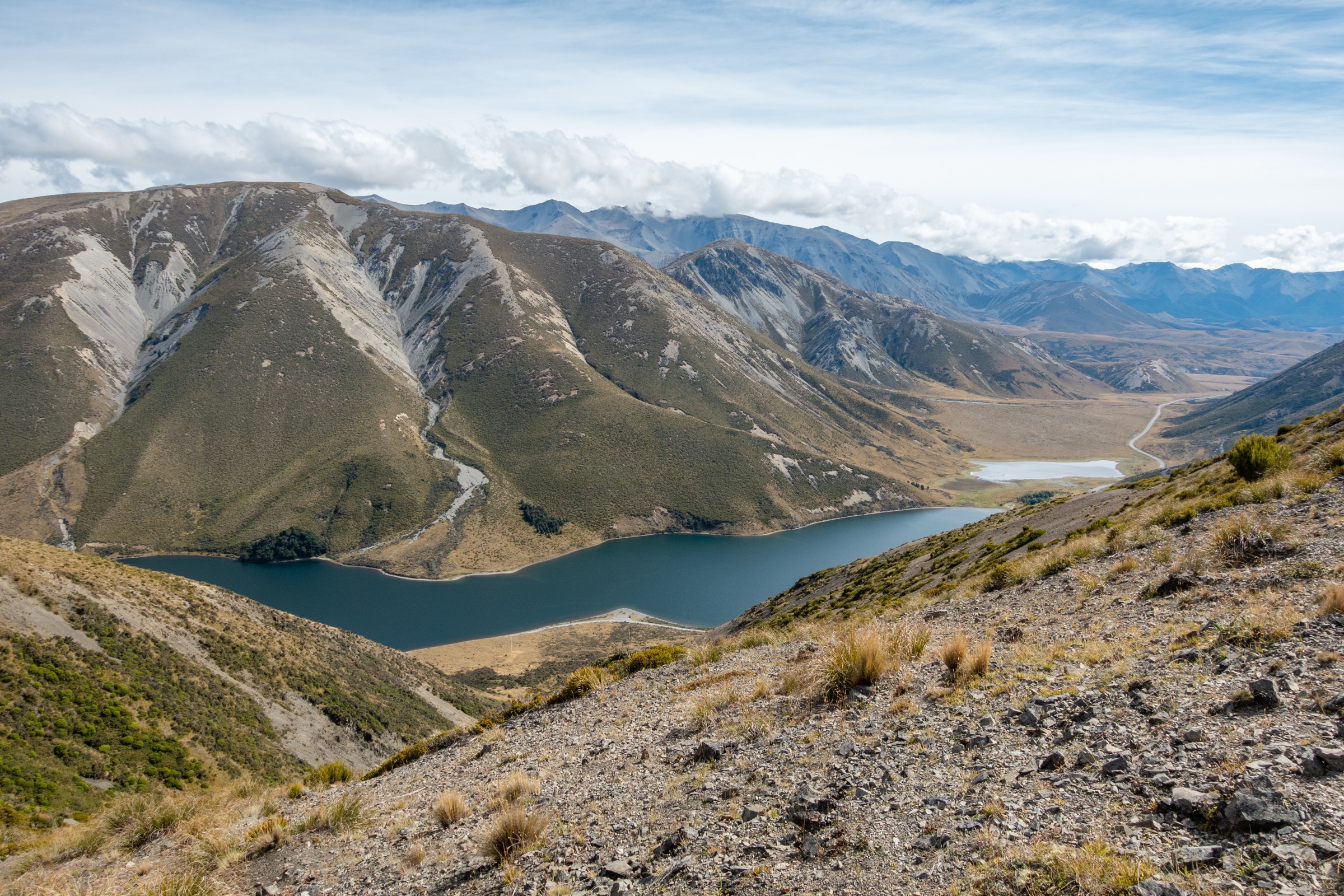
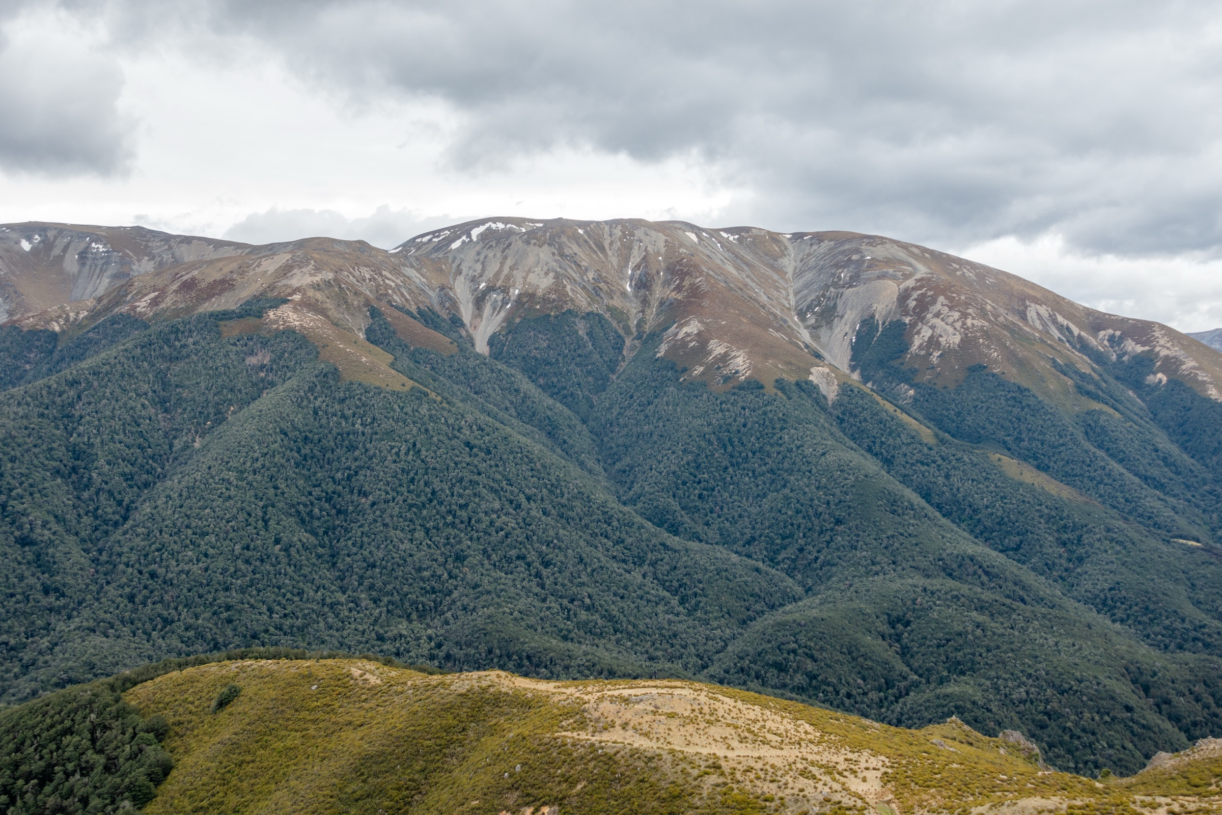
At the base of Big Ben the marked tramping track ends and a poled “route” begins, climbing the steep south-east face on a rough trail through scree and tussock. A 1,000 m bench at Pt 962 offers a rest and sweeping views of the Rakaia Valley. The grade eases on the climb to a false summit, then a long open slope reaches Big Ben (1,416 m). The summit panorama covers the Canterbury Plains, the lower Rakaia and Wilberforce basins, Lake Coleridge, Mount Hutt and the Big Ben Range rolling north-west. Return is by the same route.
Why it is essential
Big Ben is the highest named summit of the Big Ben Range and one of only two stand-alone day-summits inside the park that does not belong to the Mount Torlesse area. Its setting — above the Lake Coleridge basin, looking south into the Rakaia rather than north into the Waimakariri — represents the southern face of the park that no other hike here covers. The Dry Acheron approach is also the park’s longest formally signed track and the first New Zealand walkway gazetted under the Walking Access Act.
Equipment
Mountain hiking equipment: sturdy boots (multiple stream crossings), gaiters useful, weatherproof shell, extra warm layer, sun protection (south-east face is fully exposed once above the stream), trekking poles, navigation backup (poles can be hard to spot above Pt 1200), headtorch. Carry water — the upper face holds no reliable supply.
Hazards and notes
No dogs are permitted (private farmland easement). The stream crossings can rise quickly after rain; do not attempt the route after heavy precipitation. The poled summit climb is unmarked above the 1,300 m contour in places; in low cloud navigation becomes harder. Stay on the marked route at all times and inside the boundaries of covenant areas. Cross fences only at stiles. The summit is exposed to the full nor’wester gale; pace the ascent to keep an exit margin before afternoon weather. Wasps are abundant January–April in the lower stream sections.
Verification status
Verified — DOC track, Wilderness Magazine GPS-measured statistics, Wikimedia photo evidence on adjacent ridges. No Wikimedia photograph of Big Ben summit itself was located in research; the Big Ben Range image used above is from the adjacent Annavale ridge.
GPX / KML links
| Source | URL |
|---|---|
| DOC — Dry Acheron Track | doc.govt.nz |
| Wilderness Magazine — Big Ben | wildernessmag.co.nz |
| Wilderness Magazine — Big view on Big Ben | wildernessmag.co.nz |
| Plan My Walk — Dry Acheron to Big Ben | planmywalk.nz |
| AllTrails — Big Ben Saddle Track | alltrails.com |
| OpenStreetMap — Dry Acheron and Big Ben routes | openstreetmap.org |
5. Dry Acheron Track lower section (covenant walk)
Snapshot
Itinerary
The lower Dry Acheron Track is a moderate streambed walk that does not climb Big Ben and is therefore a feasible “fair-weather” day for parties not seeking the 1,009 m summit ascent. From the Coleridge Road car park the marked route crosses farmland for about 2 km then drops into the Dry Acheron Stream, which it follows upstream through a series of small gorges, scrubland terraces and matagouri flats. At about 5 km a signposted side track climbs the terrace 10 minutes to the Clay Gully covenant — a small reserve of regenerating native scrub. The track continues in the streambed, with intermittent DOC markers, to the junction with the Big Ben summit route at 8 km. A further side-trip from this junction climbs 30 minutes to the Conical Knoll covenant for elevated views of the lower Rakaia. Returning the same way is the standard option.
Why it is essential
Without the Big Ben summit, this is the only marked DOC “track” walk inside the park that delivers a half-day on conservation land with negligible elevation gain. It is the natural choice for parties with limited fitness, marginal weather or off-season conditions when the higher ridges are unsafe.
Equipment
Standard hiking equipment, sturdy boots tolerant of wet feet, gaiters useful, weatherproof shell, sun protection. No dogs. Carry water.
Hazards and notes
The streambed is the route — high water makes the walk impassable. Cross fences only at stiles and stay within the marked easement. Wasps abundant January–April. The route crosses two private stations under access agreement; respect stock and gates.
Verification status
Partially verified — DOC track and times confirmed; no licence-clear photograph of the Dry Acheron streambed was located on Wikimedia Commons in this research pass. The DOC page uses an “Edward Hathway | Creative Commons” thumbnail whose specific licence terms should be verified directly with the author at hikingscenery.com.
GPX / KML links
| Source | URL |
|---|---|
| DOC — Dry Acheron Track | doc.govt.nz |
| Hiking Scenery — Dry Acheron Track | hikingscenery.com |
| OpenStreetMap — Dry Acheron Track | openstreetmap.org |
Missing data and follow-up
A handful of items remain open from the research pass and are worth flagging for revision:
- Park establishment date. Primary government sources (Hon. Sandra Lee’s opening speech, beehive.govt.nz) confirm the opening on 2 November 2001. A Forest and Bird newsletter reference to “late 2003” may instead describe a later boundary expansion and should be reconciled against the New Zealand Gazette.
- “Sharks Tooth” feature. The verified “Sharks Tooth” in New Zealand is in Mount Aspiring National Park, not the Torlesse Range. The likely intended feature here is The Gap — a rectangular notch in the Torlesse main ridge between Castle Hill Peak and Red Peak — which is reached only via the Foggy Peak / Castle Hill Peak ridge and therefore belongs in the Mount Torlesse Area article.
- GPX licence terms. Wilderness Magazine publishes downloadable GPX for several routes here (Big Ben, Benmore Hut, The Gap) but no explicit reuse licence; AllTrails community traces are behind login. The cleanest path is redrawing geometry from OpenStreetMap ways under ODbL with attribution.
- Big Ben summit photograph. No Wikimedia Commons image of the Big Ben summit itself was located; the Big Ben Range image from the Annavale Circuit serves as a substitute.
- Dry Acheron streambed photograph. No licence-compatible image of the streambed or covenants was located on Wikimedia Commons in this research pass.
- Trig M elevation gain. DOC publishes neither elevation gain nor trailhead elevation for the Trig M or Coach Stream routes. Stated gains here are derived from contour subtraction on NZTopo50 BW21 and should be cross-checked against a GPS profile.
- Brooksdale Station access. Routes onto Mount Torlesse via the Kowai River require permission from Brooksdale Station; DOC does not publish contact details. These approaches are in scope for the Mount Torlesse Area article.
- Wasp season. DOC’s January–April warning applies; activity peaks need local confirmation before publication of specific tour dates.
- Defence Force training schedule. Exercises take place in the park but timing is not published; no effect on public access is documented. Verify via Arthur’s Pass Visitor Centre (+64 3 318 9211) before publication.
External links
| Source | URL |
|---|---|
| DOC — Korowai/Torlesse Tussocklands Park | doc.govt.nz |
| DOC — Korowai/Torlesse Tussocklands Park routes | doc.govt.nz |
| DOC — Trig M Route | doc.govt.nz |
| DOC — Coach Stream Route | doc.govt.nz |
| DOC — Dry Acheron Track | doc.govt.nz |
| Herenga ā Nuku Aotearoa — Annavale Track | herengaanuku.govt.nz |
| Wilderness Magazine — Benmore Hut via Annavale Track (2025) | wildernessmag.co.nz |
| Wilderness Magazine — Benmore Hut (2016) | wildernessmag.co.nz |
| Wilderness Magazine — Big Ben (2025) | wildernessmag.co.nz |
| Wilderness Magazine — Cruising the old coach road (2013) | wildernessmag.co.nz |
| Hiking Scenery — Big Ben via Dry Acheron Stream | hikingscenery.com |
| Hiking Scenery — Dry Acheron Track | hikingscenery.com |
| Hon. Sandra Lee — Speech to open the Korowai Torlesse Tussocklands Park, 2 November 2001 | beehive.govt.nz |
| Wikipedia — Korowai / Torlesse Tussocklands Park | en.wikipedia.org |
| Wikidata — Korowai / Torlesse Tussocklands Park | wikidata.org |
| Wikimedia Commons — Michal Klajban (Podzemnik) Canterbury series | commons.wikimedia.org |
| Plan My Walk (NZ Mountain Safety Council) — Dry Acheron to Big Ben | planmywalk.nz |
| NZ Topo Map — BW21 Springfield (online viewer) | topomap.co.nz |