Regional overview
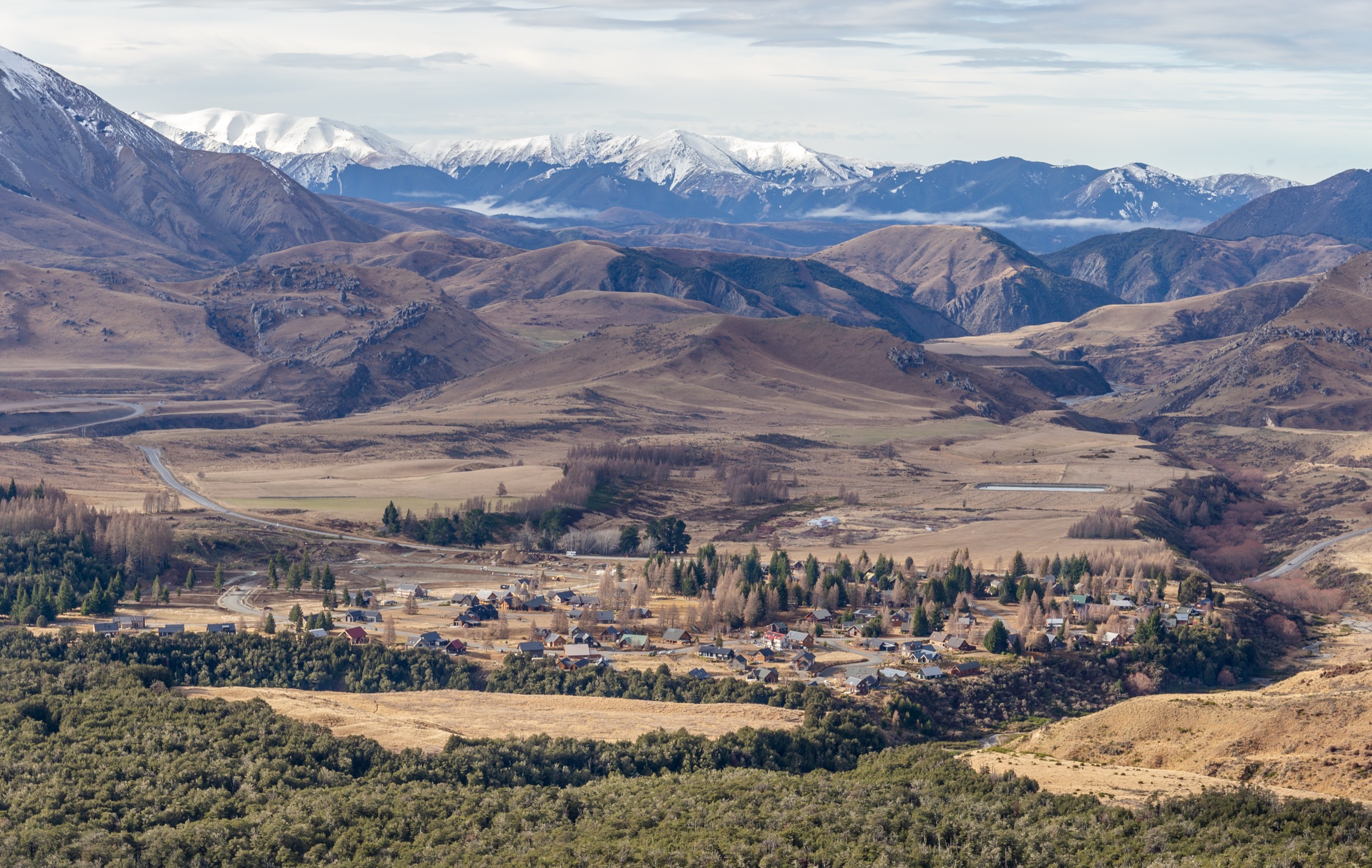
Castle Hill Basin (Māori: Kura Tāwhiti) is a broad intermontane basin in inland Canterbury, sitting at roughly 700 m above sea level on State Highway 73 between the Torlesse Range to the south-east and the Craigieburn Range to the north-west. The basin is the most accessible piece of high country between Christchurch and Arthur’s Pass: the highway crosses Porters Pass (942 m) at its eastern edge, threads past Lake Lyndon, Castle Hill village, the limestone tors of Kura Tāwhiti, Cave Stream Scenic Reserve, and Lakes Pearson (Moana Rua) and Grasmere before dropping into the Waimakariri.
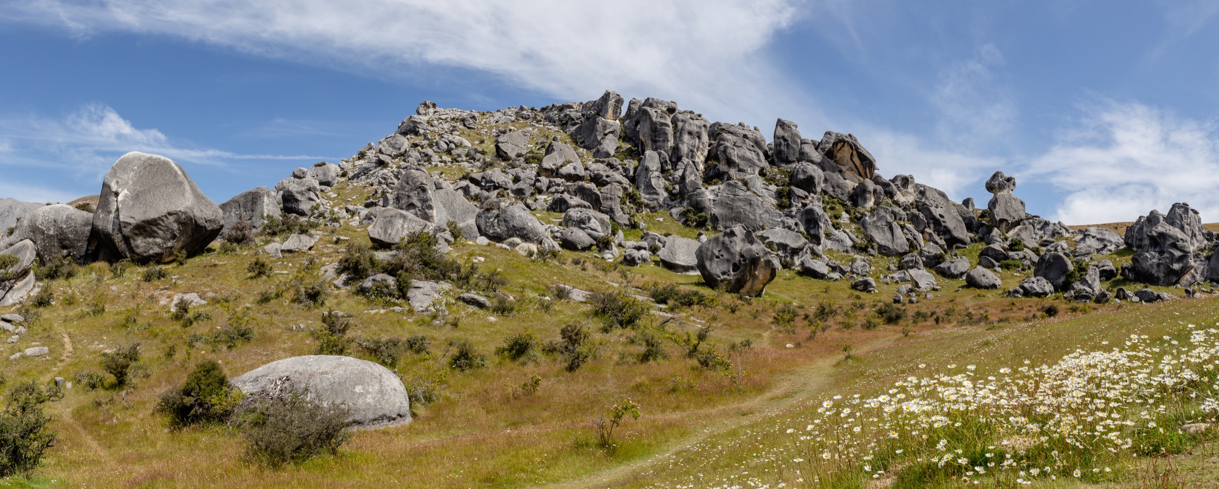
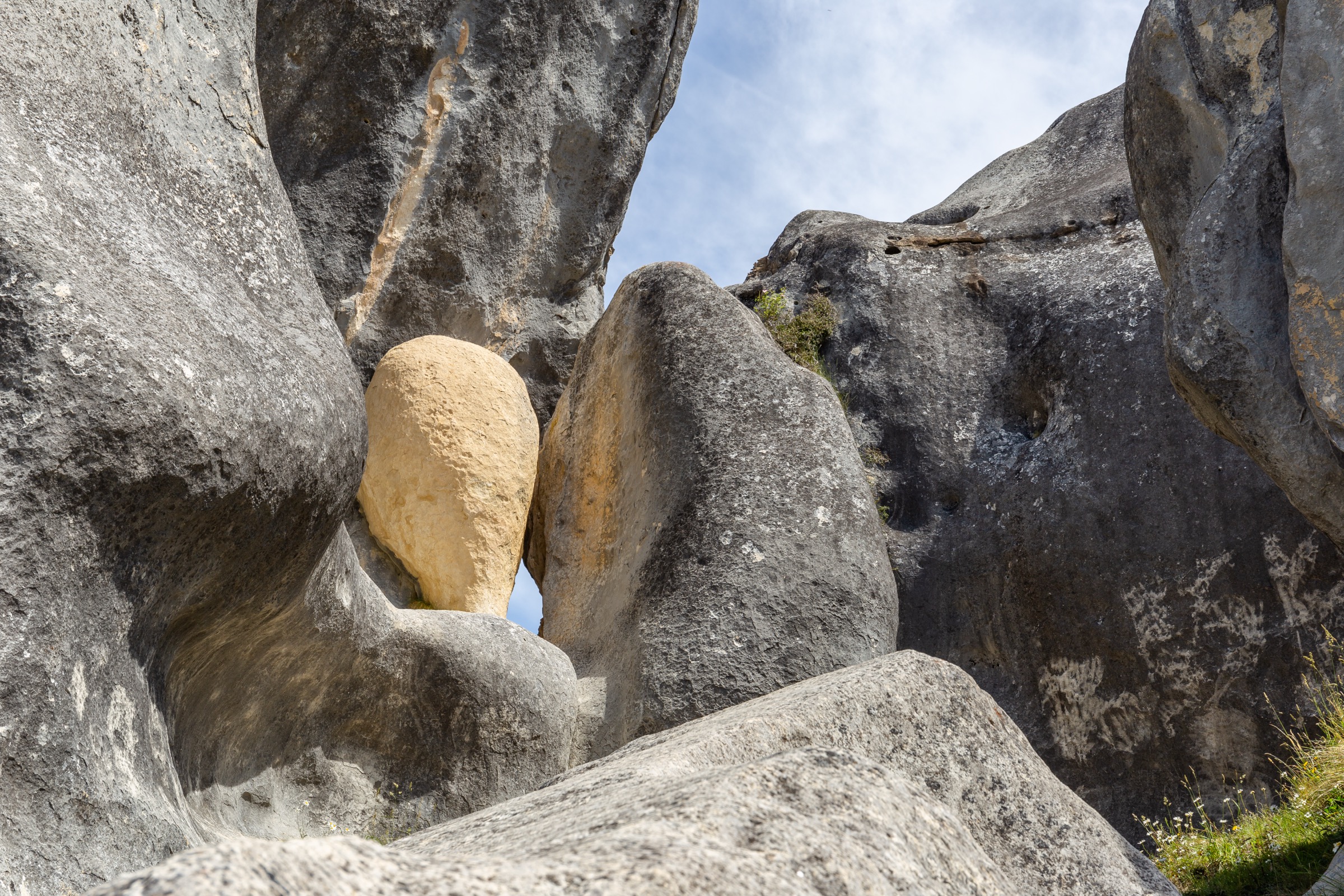
The basin’s character is dictated by its geology and its dryness. Oligocene limestone has weathered into the karst towers, slabs, and arches that make Kura Tāwhiti one of the world’s better-known bouldering venues; the same rock hosts Cave Stream, a 594 m through-cave on State Highway 73. The surrounding tussock fans, glacial moraines, and small kettle-hole lakes lie in a rain shadow, producing a landscape closer to inland Otago than to the wet beech forests of nearby Arthur’s Pass. The Torlesse and Craigieburn ranges rise steeply on either side to peaks above 1,900 m.
Hiking in the basin itself is dominated by short interpretive walks and approach tracks. The genuinely iconic outings are the limestone walks at Kura Tāwhiti and the loop at Cave Stream; longer day-tramps almost all leave the basin and climb either west into the Craigieburn Forest Park alpine area or south into the Korowai/Torlesse Tussocklands Park on the Torlesse main divide. Within the basin proper there are four widely walked routes; the Trig M tramp from Starvation Gully, which is sometimes described in basin guides, sits inside Korowai/Torlesse Tussocklands Park and is covered by the companion article on that area.
Access is straightforward in all but extreme weather: SH73 is a sealed, all-weather state highway served by the West Coast TranzAlpine train (Springfield, Arthur’s Pass stations — neither stops in the basin itself) and by InterCity / Atomic coach services that will set down on request. The basin is open year-round, but easterly snow can briefly close Porters Pass in winter, and the broad open tussock is fully exposed to the north-west föhn winds that drive heavy weather across the Main Divide.
Selection rationale
Castle Hill Basin is best known for limestone bouldering, scenic driving, and short interpretive walks rather than for mountain hiking. Of the four hikes selected, two (Kura Tāwhiti, Cave Stream) are short walks of well under an hour but are inarguably the iconic outings of the basin and appear on every official list. The other two (Lake Pearson shoreline; Leith Hill Loop from Thomas Bush) are longer easy-to-moderate walks that genuinely sit inside the basin geography.
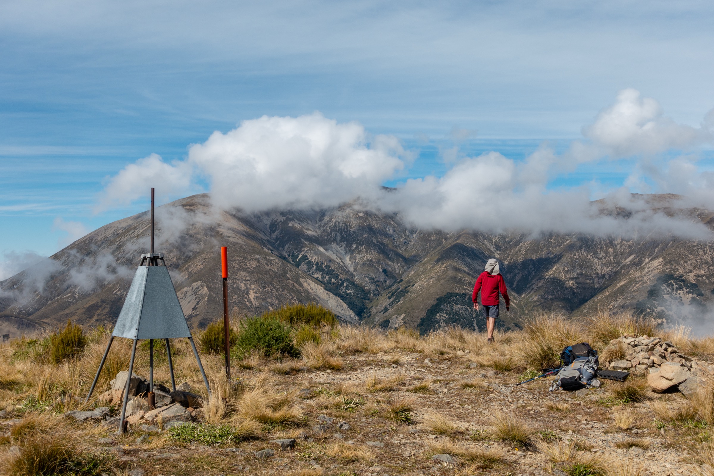
The summit climb of Castle Hill Peak (1,998 m) via Foggy Peak from Porters Pass is deliberately excluded: it belongs to the Mount Torlesse Area spec, and although Porters Pass forms the basin’s south-east edge the route is universally described as a Torlesse Range ridge tramp rather than a Castle Hill Basin walk. The Trig M Route from Starvation Gully — a sub-alpine tramp on the basin’s edge — is also excluded here because it starts inside Korowai/Torlesse Tussocklands Park and is covered by that article. Likewise, the Craigieburn Forest Park tracks (Helicopter Hill, Mistletoe, Hogs Back / Picnic Rock, Bealey Spur) are excluded by the brief even though several start within a few kilometres of Castle Hill village.
The basin does not support a full set of five classic day-hikes. The four listed below mix very short interpretive walks with two longer easy-to-moderate walks in order to represent the basin honestly.
Summary table
| # | Hike | Country | Route type | Distance | Gain | Max elevation | Difficulty |
|---|---|---|---|---|---|---|---|
| 1 | Kura Tāwhiti / Castle Hill Access Track + tors network | New Zealand | Out-and-back + free exploration | ~1.4 km formed; up to ~2.5 km with full tors loop | ~65 m | ~775 m | Easy |
| 2 | Cave Stream Scenic Reserve Loop Walk | New Zealand | Loop | ~1.5 km | ~40 m | ~620 m | Easy |
| 3 | Lake Pearson / Moana Rua shoreline walk | New Zealand | Out-and-back along shore | 3–5 km | Negligible | ~620 m | Easy |
| 4 | Leith Hill Loop (Thomas Bush) | New Zealand | Loop | ~5 km | ~300 m | ~1,014 m | Easy–moderate |
1. Kura Tāwhiti / Castle Hill Access Track and tors network
Snapshot
Itinerary
The walk leaves a sealed car park immediately off SH73 between Porters Pass and Castle Hill village. A gravel access track climbs gently across open pasture for approximately 500 m, with short sections of steps, to reach the base of the limestone formations. From this point the route is informal: a network of unmarked but well-worn paths weaves between the tors, allowing visitors to circle the main group of boulders, reach the higher tors on the lower slope of Castle Hill, and return to the car park by various lines. The formed track ends at the lower boulders; everything beyond is at the walker’s discretion within the Conservation Area boundary. A short walk of around 1.4 km return takes 20–30 minutes; a thorough wander among the tors typically takes 1–2 hours.
Why it is essential
Kura Tāwhiti is the single most-visited site in the Castle Hill Basin and the headline image of the basin on virtually every Canterbury tourism resource. The karst tors are nationally significant geologically, ecologically (it is the only habitat of the Castle Hill buttercup, Ranunculus crithmifolius subsp. paucifolius), and culturally — the area carries Tōpuni status under the 1998 Ngāi Tahu Claims Settlement Act, recognising its importance to Ngāi Tahu as a wayfinding, shelter and food-gathering site. Selecting any list of essential walks in the basin without Kura Tāwhiti would be indefensible.
Equipment
Standard hiking equipment is sufficient: sturdy shoes, weatherproof layer, water, sun protection. Footwear with reasonable grip is useful on damp limestone. No technical equipment is required for walking; climbers using the tors carry their own kit.
Hazards and notes
Dogs and bikes are not permitted in the Conservation Area. Under Tōpuni status visitors are asked to respect the wāhi tapu nature of the site; rock art on certain tors must not be touched. Limestone becomes very slick when wet and falls among the boulders are the most common incident here. There is no water source and no toilets at the car park (the nearest are at Cave Stream and at Castle Hill village). Access is free and no permit is required.
GPX / route links
| Source | URL |
|---|---|
| DOC — Kura Tāwhiti Access Track | doc.govt.nz |
| PlanMyWalk — Kura Tāwhiti Access Track | planmywalk.nz |
| OpenStreetMap — Kura Tāwhiti area | openstreetmap.org |
2. Cave Stream Scenic Reserve Loop Walk
Snapshot
Itinerary
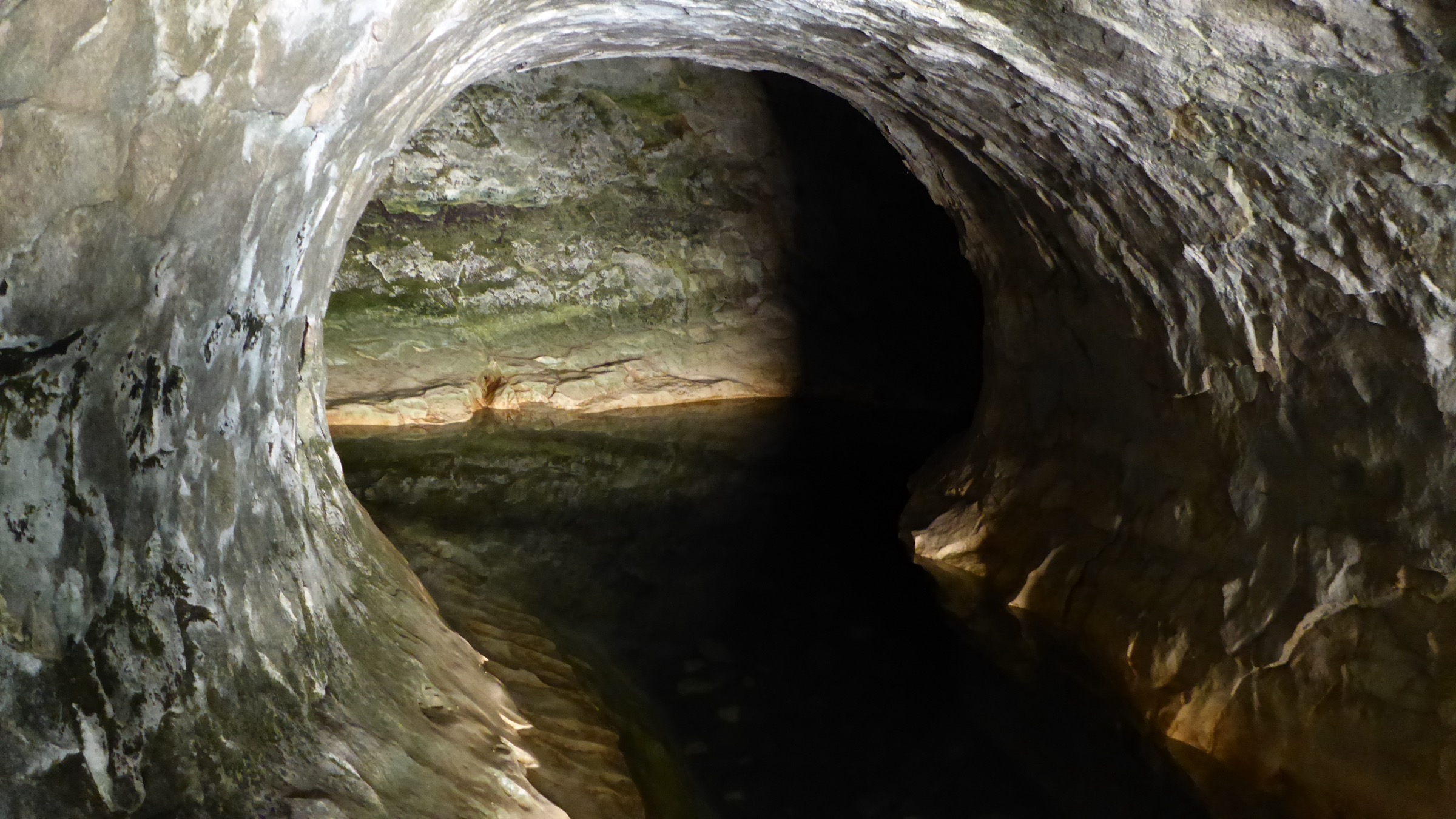
From the car park and toilet block on the north side of SH73, the loop walk descends through scrub and short tussock onto the limestone terrace above Broken River. A short branch leads to a viewpoint above the lower entrance of Cave Stream — a slot in the rock where the stream emerges from its 594 m underground passage. The main track continues across grassed terraces with interpretive panels covering geology, karst hydrology, and Ngāi Tahu use of the area, then descends to a second viewpoint above the upper (sink) entrance where the stream disappears into the cliff. The loop returns to the car park along the upper terrace. The cave passage itself is a popular but serious caving objective and is explicitly outside the scope of this walk.
Why it is essential
Cave Stream is the second of the basin’s two headline natural features and the only public-access through-cave on a New Zealand state highway. The surface loop is short but presents the limestone hydrology of the basin in a way that complements Kura Tāwhiti, and it is on every regional walks list.
Equipment
Standard hiking equipment is enough for the surface walk: shoes with grip, weatherproof layer, water. Anyone proposing to traverse the cave itself requires two reliable torches per person plus spares, warm wool or polypropylene clothing, sturdy footwear, a helmet, and full awareness of the drowning and hypothermia risk — and should consult DOC’s separate caving guidance.
Hazards and notes
People have died in the cave. The surface walk is safe in normal conditions; the cave is not. Avoid the cave entirely after rain or in unsettled weather — stream rises can be sudden and lethal. Limestone surfaces are slippery when wet. Toilets and a car park are provided but there is no drinking water on site. Dogs are permitted on a lead in the reserve but not within the cave; check current DOC signage before bringing a dog.
GPX / route links
| Source | URL |
|---|---|
| DOC — Cave Stream Loop Walk | doc.govt.nz |
| DOC — Cave Stream brochure (PDF) | doc.govt.nz |
| PlanMyWalk — Cave Stream Loop Walk | planmywalk.nz |
| OpenStreetMap — Cave Stream Scenic Reserve | openstreetmap.org |
3. Lake Pearson / Moana Rua shoreline walk
Snapshot
Itinerary
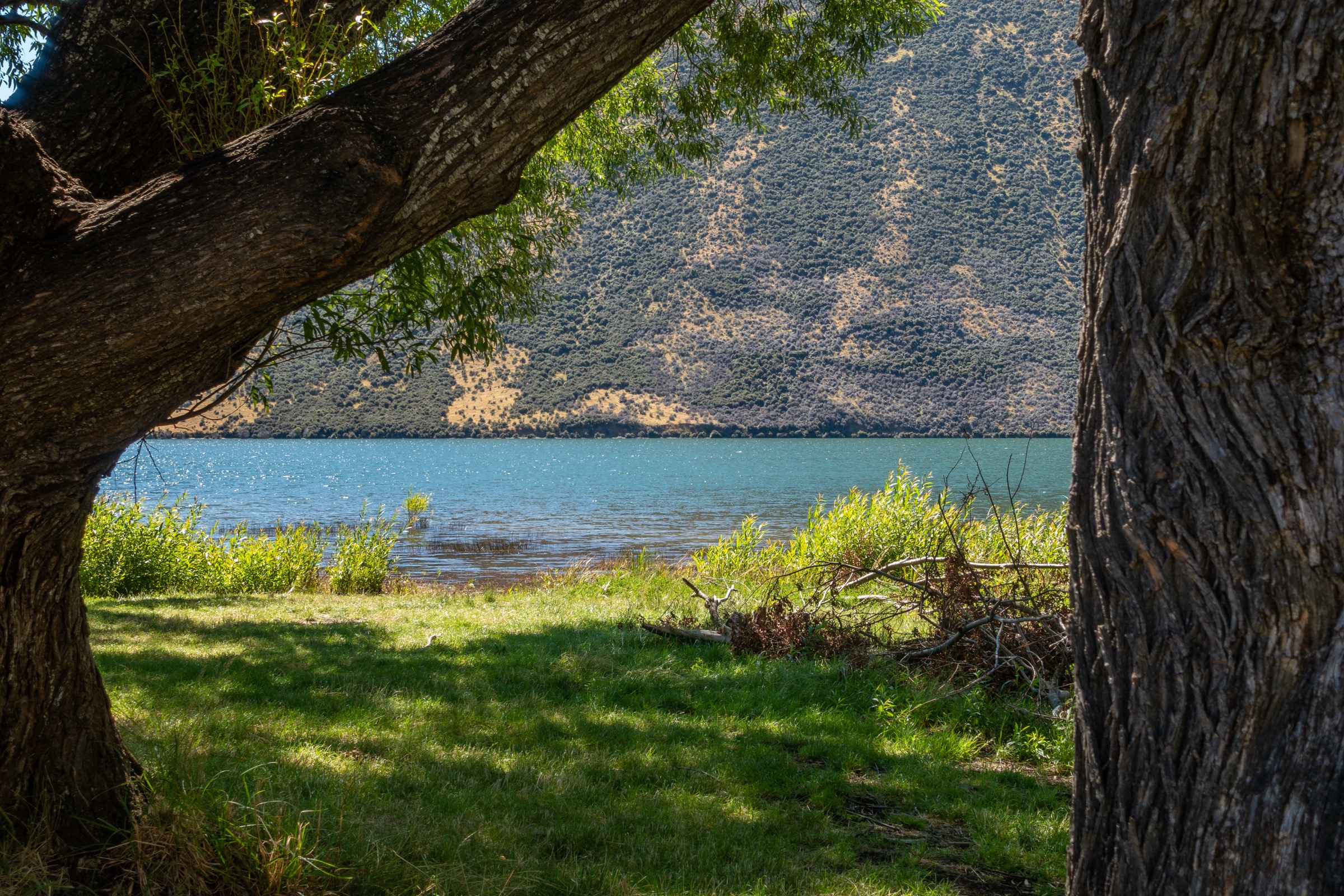
The walk begins at the DOC standard campsite on the north-west shore of Lake Pearson, a glacially formed hourglass-shaped lake within a wildlife refuge. An informal walking line follows the shoreline along the gravel and tussock terraces; with care it is possible to walk a substantial proportion of the lake’s perimeter, but there is no continuous formed track and short detours around marshy bays are sometimes needed. The route is most commonly walked as a casual there-and-back from the campsite for 1–2 hours. The Torlesse and Craigieburn ranges form the backdrop in both directions, and the lake is notable for crested grebe (pūteketeke) and other waterbirds.
Why it is essential
Lake Pearson is the largest and most visible of the basin’s kettle-hole and glacial lakes from SH73, and it is the only major wildlife refuge in the basin. It offers the only easy walking in the basin that combines water, mountain backdrop, and birdlife in a single short route, and it is widely listed on regional walking and birding resources.
Equipment
Standard hiking equipment: shoes, weatherproof layer, water, sun protection. The lake is at altitude and exposed; an extra warm layer is useful outside midsummer.
Hazards and notes
The shoreline route is informal; navigation is by line of sight along the shore. The lake is a wildlife refuge: dogs should be kept on lead and away from nesting birds, and current DOC signage on dog access should be checked. Strong nor’westers can blow up quickly across the open water. The DOC campsite has long-drop toilets but no treated water; fees apply for camping but not for day use. Fishing is permitted in season under a Fish & Game licence and anglers may be encountered along the shore.
GPX / route links
| Source | URL |
|---|---|
| DOC — Lake Pearson (Moana Rua) campsite | doc.govt.nz |
| Our Lakes Our Future — Lake Pearson / Ōpōrea | ourlakesourfuture.co.nz |
| PlanMyWalk — Lake Pearson Moana Rua campsite | planmywalk.nz |
| OpenStreetMap — Lake Pearson shoreline | openstreetmap.org |
4. Leith Hill Loop (Thomas Bush)
Snapshot
Itinerary
From the Thomas Bush car park at the edge of Castle Hill village, the route follows Castle Hill Drive for ~300 m and turns onto Trelissick Loop Road for ~220 m to reach the Thomas River Track start. The track enters the native mountain-beech (Fuscospora cliffortioides) forest of Thomas Bush and crosses the Thomas River, then takes the right-hand branch and ascends steadily through the forest. The track emerges from the trees into a prominent basin on the side of Leith Hill locally called “The Depression” — a closed-drainage karst sinkhole. From here the loop sidles gently around to the high point at approximately 1,014 m, with open views across the entire Castle Hill Basin to the Torlesse and Craigieburn ranges, before descending on the return arm of the loop back to the village and the car park.
Why it is essential
The Leith Hill Loop is the only longer, view-rewarding hike that begins directly from Castle Hill village within the basin proper, and the only one of the basin’s walks that combines native beech forest, karst landform (the Depression sinkhole), and a panoramic basin viewpoint in a single loop. It is the de facto “village walk” for Castle Hill, jointly maintained by the Castle Hill Community Association and DOC.
Equipment
Standard hiking equipment plus trekking poles useful on the steeper descent. An extra warm layer is useful outside midsummer; the upper loop is exposed to nor’west winds. Navigation backup is advisable in cloud as the upper loop briefly leaves the forest.
Hazards and notes
The Thomas River rises rapidly during rainfall and can be impassable; do not cross if it is running high or discoloured. The track is muddy and slippery after rain, and the upper loop is exposed to weather that can change quickly. DOC publishes this track under the Craigieburn Forest Park URL, but the trailhead and walking experience sit within Castle Hill village in the basin proper, which is why it is listed here rather than under the Craigieburn alpine area. Dogs: check current Castle Hill Community Association and DOC guidance, as some sections cross private interests.
GPX / route links
| Source | URL |
|---|---|
| DOC — Leith Hill Loop Track | doc.govt.nz |
| DOC — Thomas River Track | doc.govt.nz |
| Castle Hill Community Association — tracks | chca.org.nz |
| AllTrails — Leith Hill Loop | alltrails.com |
Notes and follow-up
The Castle Hill Basin does not support a full set of five strenuous classic day-hikes. The four selected mix two very short interpretive walks (Kura Tāwhiti, Cave Stream) with one easy shoreline walk (Lake Pearson) and one easy-to-moderate forested loop (Leith Hill). All longer alpine objectives in this part of inland Canterbury belong to neighbouring regions — Craigieburn Forest Park, the Mount Torlesse Area, and Korowai/Torlesse Tussocklands Park — and are covered in the companion articles for those areas. In particular, the Trig M Route from Starvation Gully, sometimes described in basin guides, sits inside Korowai/Torlesse Tussocklands Park and is covered there rather than here.
No official GPX exists for any of the four hikes: DOC walks pages consistently lack GPX downloads, and OSM way geometry is available under ODbL for all four but no curated OSM hiking-route relation has been identified for any of them. The Lake Pearson shoreline route is informal and should be treated as a casual stroll rather than as a defined track. Visitors should not enter the small fenced Castle Hill buttercup enclosure within Kura Tāwhiti, and should follow current DOC signage on Tōpuni protocols on site, as wording and enclosure location may change.
External links
| Source | URL |
|---|---|
| DOC — Kura Tāwhiti (Castle Hill) area | doc.govt.nz |
| DOC — Kura Tāwhiti Access Track | doc.govt.nz |
| DOC — Cave Stream Scenic Reserve | doc.govt.nz |
| DOC — Cave Stream Loop Walk | doc.govt.nz |
| DOC — Caving at Cave Stream | doc.govt.nz |
| DOC — Lake Pearson (Moana Rua) campsite | doc.govt.nz |
| DOC — Leith Hill Loop Track | doc.govt.nz |
| DOC — Thomas River Track | doc.govt.nz |
| Selwyn District Council — Kura Tāwhiti / Castle Hill | selwyn.nz |
| Castle Hill Community Association — tracks | chca.org.nz |
| University of Canterbury — A field guide to the geology of the Castle Hill Basin (PDF) | canterbury.ac.nz |
| New Zealand Geographic — The rocks of Castle Hill | nzgeo.com |
| Te Ara — Porters Pass to Arthur’s Pass | teara.govt.nz |
| Geotrips — Kura Tāwhiti / Castle Hill | geotrips.org.nz |
| newzealand.com — Kura Tāwhiti Access Track | newzealand.com |
| Arthur’s Pass Visitor Guide — Kura Tawhiti | arthurspass.com |
| Arthur’s Pass Visitor Guide — Cave Stream | arthurspass.com |
| ChristchurchNZ — Castle Hill | christchurchnz.com |
| Wikipedia — Castle Hill, New Zealand | en.wikipedia.org |
| Wikipedia — Castle Hill Peak | en.wikipedia.org |
| Wikipedia — Cave Stream | en.wikipedia.org |
| Wikipedia — Korowai / Torlesse Tussocklands Park | en.wikipedia.org |
| Wikimedia Commons — Castle Hill (New Zealand) | commons.wikimedia.org |
| Wikimedia Commons — Cave Stream | commons.wikimedia.org |
| Wikimedia Commons — Lake Pearson | commons.wikimedia.org |
| PlanMyWalk — Kura Tāwhiti Access Track | planmywalk.nz |
| PlanMyWalk — Cave Stream Loop Walk | planmywalk.nz |
| AllTrails — Castle Hill Village walking trails | alltrails.com |
| OpenStreetMap | openstreetmap.org |