Regional overview
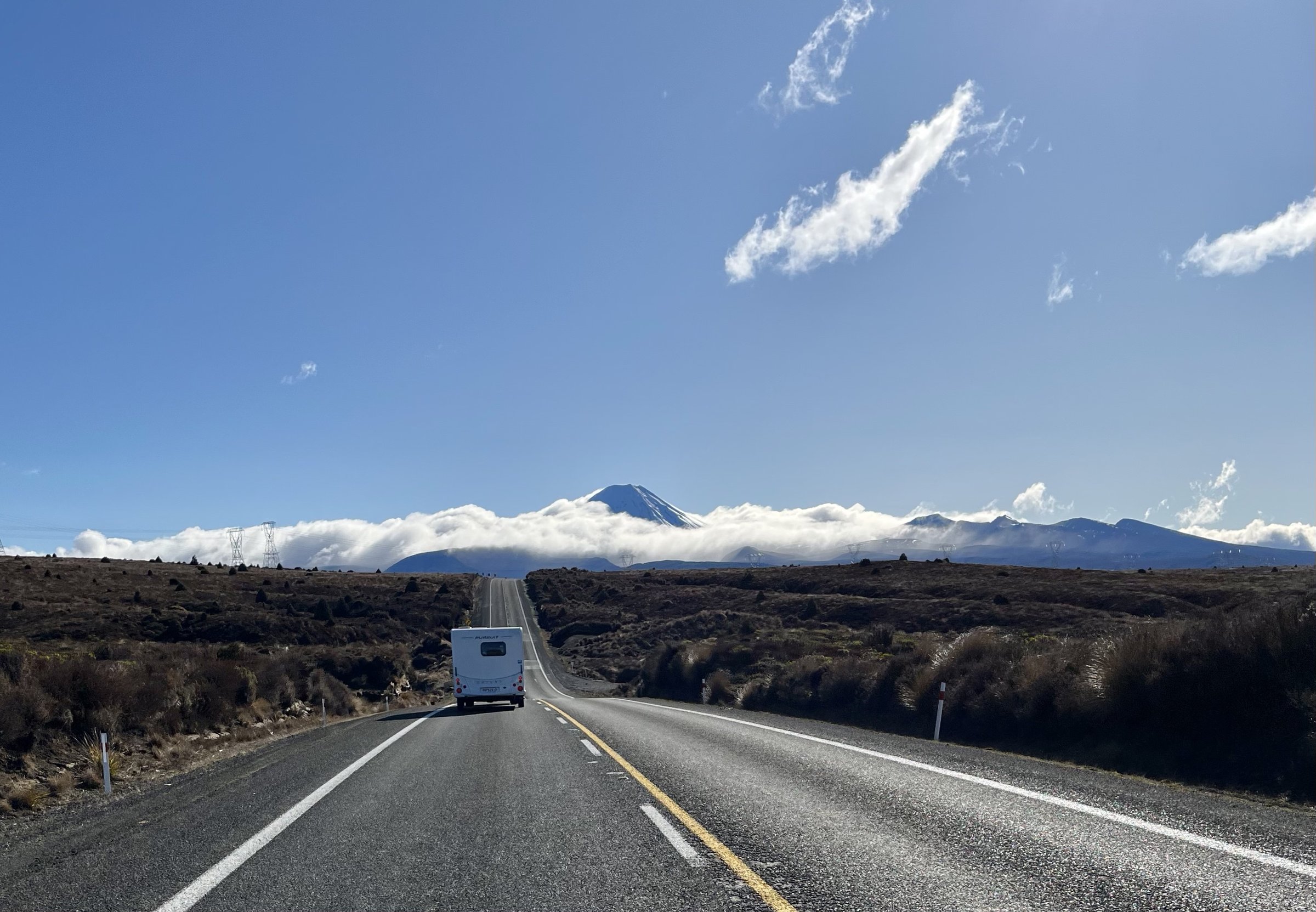
The Tongariro Massif sits in Tongariro National Park, a dual World Heritage volcanic landscape of craters, lava flows, scoria slopes, alpine herbfields, tarns, mineral springs and active volcanic hazard zones. The walking character is open, exposed and weather-sensitive even on moderate tracks.
The main hiking centres and access points are Whakapapa Village, Mangatepōpō Road, Ketetahi Road and Desert Road / Waihohonu approaches. DOC notes that strong wind, heavy rain, low cloud, snow and sub-zero temperatures can occur even outside winter.
From May to October, the high routes require winter alpine skills and equipment. The Tongariro Alpine Crossing has booking and shuttle-related requirements/recommendations, and the Mangatepōpō Track / Ditch Track section of the Tongariro Northern Circuit remains affected by the 2025 fires and route changes for the 2026/27 Great Walk season.
Selection rationale
The selected five cover the iconic Tongariro Alpine Crossing, the Tama Lakes volcanic crater-lake route, the Taranaki Falls loop, the shorter Soda Springs volcanic valley route, and the historic Waihohonu / Ohinepango Springs route on the eastern side.
Summary table
| # | Hike | Country | Route type | Distance | Gain | Max elevation | Difficulty |
|---|---|---|---|---|---|---|---|
| 1 | Tongariro Alpine Crossing | New Zealand | Point-to-point | 20.2 km | +/- 1,196 m change | c. 1,886 m Red Crater | Intermediate / expert in winter |
| 2 | Tama Lakes Track and Upper Tama Viewpoint | New Zealand | Out-and-back | 17.6 km to Lower Tama; +2.8 km upper viewpoint return | Upper lake 1,314 m; viewpoint higher unresolved | Intermediate / advanced side trip | |
| 3 | Taranaki Falls Walk | New Zealand | Loop | 6 km | Easy to intermediate | ||
| 4 | Soda Springs from Mangatepōpō | New Zealand | Out-and-back | c. 10.8 km return if using DOC TAC first 5.4 km section plus side trip | c. 1,400 m, secondary/source-image note | Intermediate | |
| 5 | Historic Waihohonu Hut and Ohinepango Springs | New Zealand | Out-and-back | 6.3 km return from Desert Road to historic hut; springs extension variable | Intermediate |
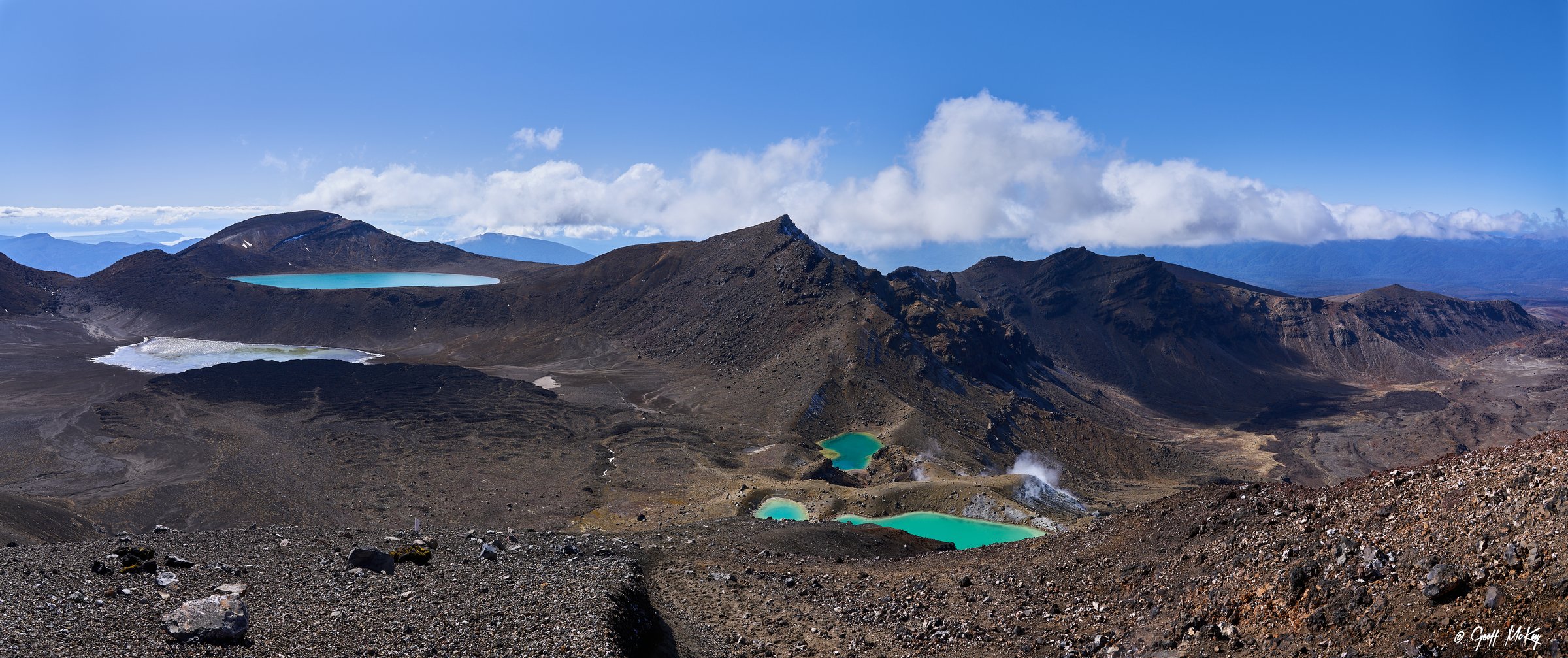
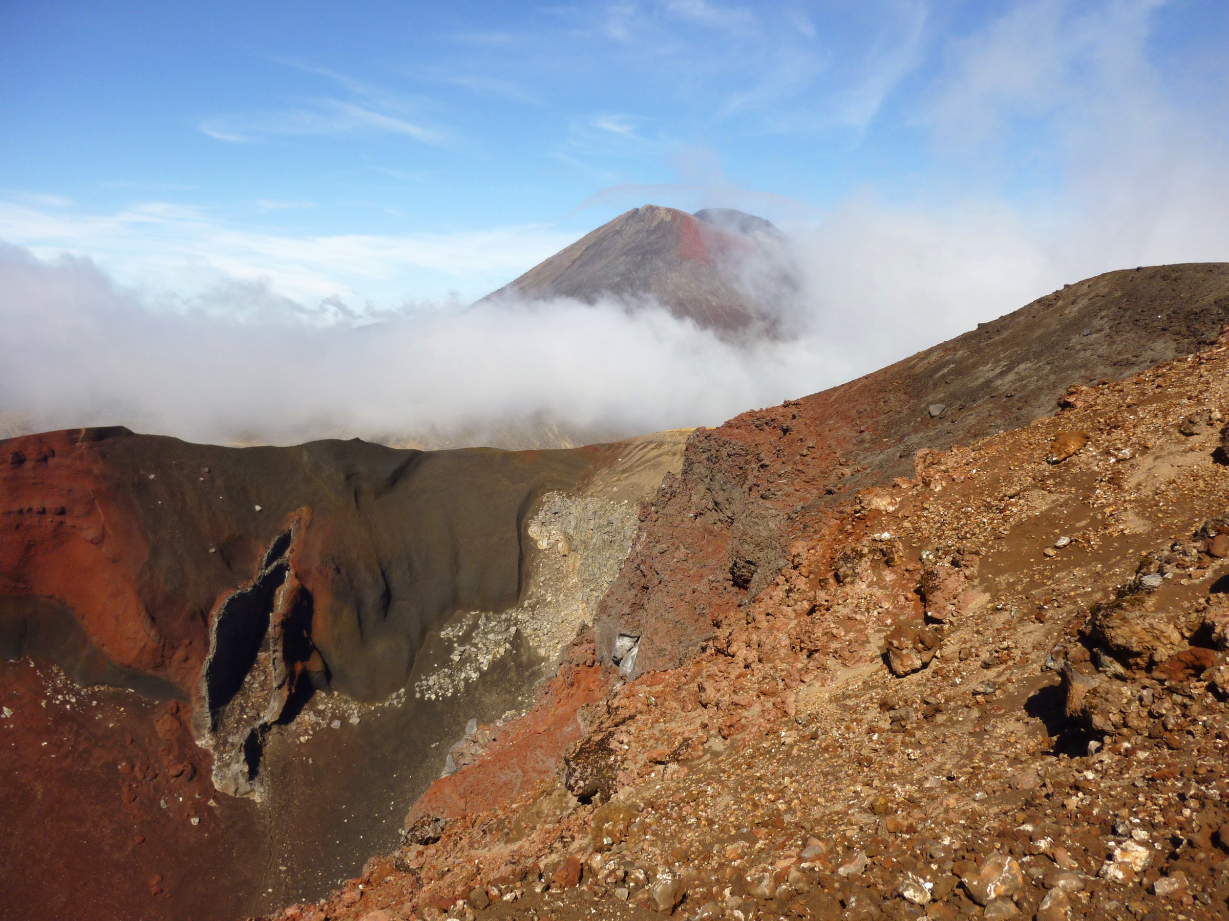
1. Tongariro Alpine Crossing
Snapshot
Itinerary
The route starts in Mangatepōpō Valley, climbs past the Soda Springs area and up the Devil’s Staircase to Mangatepōpō Saddle, crosses South Crater, climbs to Red Crater, descends loose scoria to Emerald Lakes, passes Central Crater and Blue Lake, then descends the long northern side to Ketetahi.
Why it is essential
This is New Zealand’s most famous volcanic day crossing and the key day route through the active Tongariro landscape of craters, lava flows, fumarolic terrain and coloured lakes.
Equipment
- Sturdy boots
- Waterproof and windproof layers
- Warm layers
- Hat and gloves
- Food
- Water
- Map/GPS
- Headtorch
- Sun protection
- PLB recommended
- Winter: helmet, crampons, ice axe and avalanche rescue equipment with competent use
Hazards and notes
- Bookings are recommended for all visitors and needed to use shuttle/guided services.
- The route crosses active volcanic hazard zones.
- Summer can still bring cold, strong wind, heavy rain and poor visibility.
- Winter brings snow, ice, avalanche terrain and sub-zero temperatures.
- Stay on tracks, respect rāhui/fire-affected areas, and do not climb sacred summits where discouraged by iwi/DOC guidance.
- No dogs.
GPX / KML links
| Source | URL | Format / access | Reuse status |
|---|---|---|---|
| DOC: Tongariro Alpine Crossing | doc.govt.nz | Official route page with map | DOC website terms; no GPX found |
| DOC: Tongariro Alpine Crossing summer brochure (PDF) | doc.govt.nz | PDF map/brochure | DOC website terms; source map only |
External links
2. Tama Lakes Track and Upper Tama Viewpoint
Snapshot
Itinerary
Start on the Taranaki Falls Track from Whakapapa Village. After Taranaki Falls, continue across undulating tussock and alpine herbfields to Tama Saddle and the Lower Tama Lake viewpoint. A rough unformed route climbs steeply to the Upper Tama Lake viewpoint and returns the same way.
Why it is essential
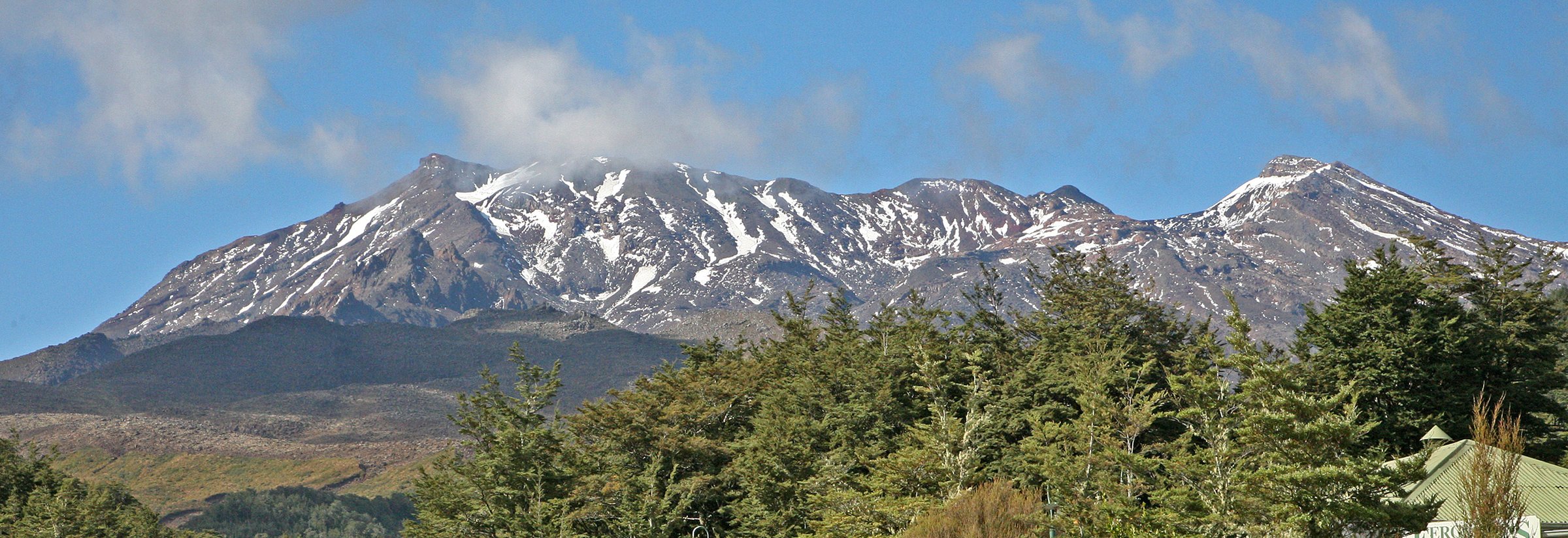
Tama Lakes gives a lower-exposure alternative to the Alpine Crossing while still reaching a classic Tongariro volcanic crater-lake landscape between Ruapehu and Ngāuruhoe.
Equipment
- Sturdy boots
- Waterproof/windproof layer
- Warm layer
- Food
- Water
- Map/GPS
- Sun protection
- Upper viewpoint in snow/ice: winter alpine equipment and skills
Hazards and notes
- There are no formed tracks down to the lakes.
- Steep gullies are unstable and the lakes should not be touched or entered.
- The Upper Tama route is loose, exposed, unformed and difficult in low cloud or strong wind.
- No dogs.
GPX / KML links
| Source | URL | Format / access | Reuse status |
|---|---|---|---|
| DOC: Tama Lakes Track | doc.govt.nz | Official route page with map | DOC website terms; no GPX found |
| DOC: Walks in and around Tongariro National Park (PDF) | doc.govt.nz | PDF map/brochure | DOC website terms; source map only |
External links
- DOC — Tama Lakes Track
- DOC — Walks in and around Tongariro National Park (PDF)
- DOC — Tongariro Northern Circuit
3. Taranaki Falls Walk
Snapshot
Itinerary
The lower track crosses tussock and alpine shrubland, enters beech forest, follows Wairere Stream and passes Cascade Falls before reaching the 20 m Taranaki Falls. The upper return climbs steps above the falls, crosses open volcanic terrain and returns to Whakapapa.
Why it is essential
This is the classic short loop from Whakapapa, linking waterfall, forest, tussock, exposed volcanic soils and views toward Ngāuruhoe and Tongariro.
Equipment
- Walking shoes or boots
- Waterproof layer
- Warm layer
- Water
- Food
- Map/GPS
- Sun protection
Hazards and notes
- The route is easier than the alpine routes but remains exposed to Tongariro weather.
- DOC notes no unauthorised drone use in the national park.
- No dogs.
GPX / KML links
| Source | URL | Format / access | Reuse status |
|---|---|---|---|
| DOC: Taranaki Falls Walk | doc.govt.nz | Official route page with map | DOC website terms; no GPX found |
| Te Araroa Trail | teararoa.org.nz | Long-trail source; Taranaki Falls section noted by DOC as part of Te Araroa | Te Araroa terms not checked; possible secondary geometry source; specific GPX not verified |
External links
4. Soda Springs from Mangatepōpō
Snapshot
Itinerary
Follow the Tongariro Alpine Crossing from Mangatepōpō through the valley on the formed lower track. Near the head of the valley, take the short marked detour to Soda Springs, a cold spring and waterfall emerging below old lava. Return by the same route.
Why it is essential
This shorter walk samples the Mangatepōpō Valley, old lava flows and Soda Springs without committing to the full Alpine Crossing.
Equipment
- Sturdy shoes or boots
- Waterproof/windproof layer
- Warm layer
- Water
- Food
- Map/GPS
- Sun protection
Hazards and notes
- This route uses part of the Tongariro Alpine Crossing corridor, so booking/shuttle rules may apply to any use of the track.
- Weather, volcanic hazards and rāhui/fire-recovery instructions still apply.
- No dogs.
GPX / KML links
| Source | URL | Format / access | Reuse status |
|---|---|---|---|
| DOC: Tongariro Alpine Crossing | doc.govt.nz | Official route page with map | DOC website terms; no GPX found |
| DOC: Tongariro Northern Circuit | doc.govt.nz | Official route page with segment description | DOC website terms; source map only |
External links
5. Historic Waihohonu Hut and Ohinepango Springs
Snapshot
Itinerary
From the Desert Road access, follow the track to Historic Waihohonu Hut, the early mountain hut dating from 1903/04. Continue where appropriate to the Ohinepango Springs side trip, where cold clear water emerges from beneath old lava into Ohinepango Stream, then return by the same route.
Why it is essential
This route adds the historical and eastern volcanic-plateau side of the Tongariro massif: the oldest typical early two-room mountain hut in New Zealand and one of the clearest spring systems in the park.
Equipment
- Sturdy footwear
- Waterproof/windproof layer
- Warm layer
- Water
- Food
- Map/GPS
- Sun protection
Hazards and notes
- The eastern side is exposed to wind and fast weather changes.
- Winter may bring snow/ice.
- Stay on formed tracks and respect protected historic structures.
- No dogs.
GPX / KML links
| Source | URL | Format / access | Reuse status |
|---|---|---|---|
| DOC: Round the Mountain / Waihohonu route information | doc.govt.nz | Official route page/source map | DOC website terms; no GPX found |
| DOC: Walks in and around Tongariro National Park (PDF) | doc.govt.nz | PDF map/brochure | DOC website terms; source map only |
| DOC: Tongariro Northern Circuit | doc.govt.nz | Official route page with side-trip details | DOC website terms; source map only |
External links
- DOC — Round the Mountain Track
- DOC — Walks in and around Tongariro National Park (PDF)
- DOC — Tongariro Northern Circuit
Missing data / follow-up work
- Official GPX/KML downloads were not found for the selected routes.
- Total ascent/descent is unresolved for all routes except the Alpine Crossing, where DOC provides an elevation-change figure rather than separated ascent/descent.
- Upper Tama viewpoint maximum elevation needs topo confirmation.
- Soda Springs and Historic Waihohonu/Ohinepango route distances should be refined against a route geometry source before publication.
- DOC-hosted Creative Commons image candidates need exact licence-variant confirmation.
External links
| Source | URL |
|---|---|
| DOC — Tongariro Alpine Crossing | doc.govt.nz |
| DOC — Tongariro Alpine Crossing summer brochure (PDF) | doc.govt.nz |
| DOC — Tama Lakes Track | doc.govt.nz |
| DOC — Taranaki Falls Walk | doc.govt.nz |
| DOC — Silica Rapids Walk | doc.govt.nz |
| DOC — Tongariro Northern Circuit | doc.govt.nz |
| DOC — Round the Mountain Track | doc.govt.nz |
| DOC — Walks in and around Tongariro National Park (PDF) | doc.govt.nz |
| DOC — 2026 Tongariro Northern Circuit update | doc.govt.nz |
| Te Araroa Trail | teararoa.org.nz |