Regional overview
The northern Pisa Range is the Queensberry, Luggate, Locharburn and northern-ridge side of the wider Pisa Conservation Area. DOC treats the Pisa Conservation Area as one 23,000 ha high-country block overlooking the Upper Clutha and Wakatipu basins, so this entry uses an editorial northern split rather than an official park subdivision.
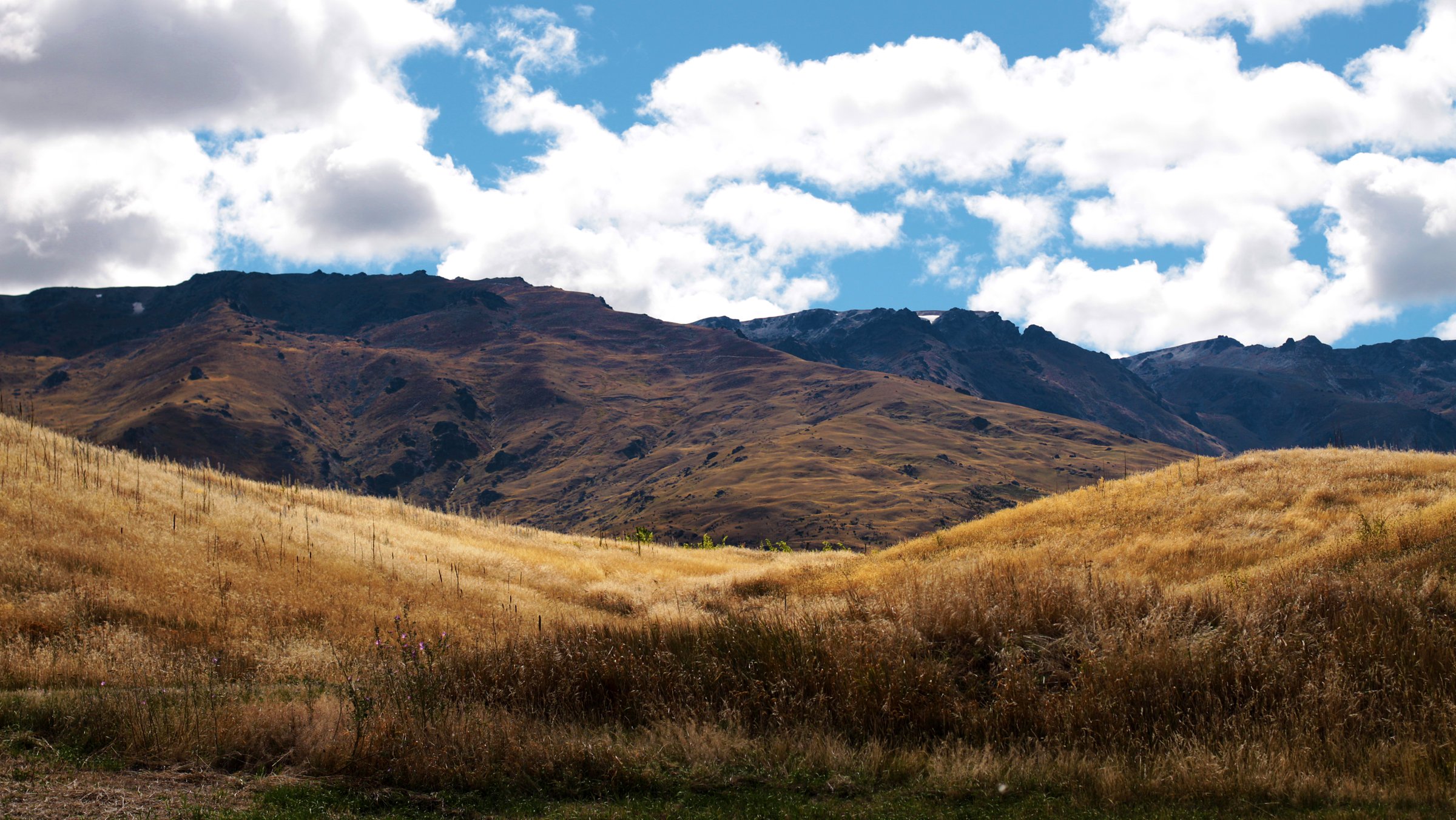
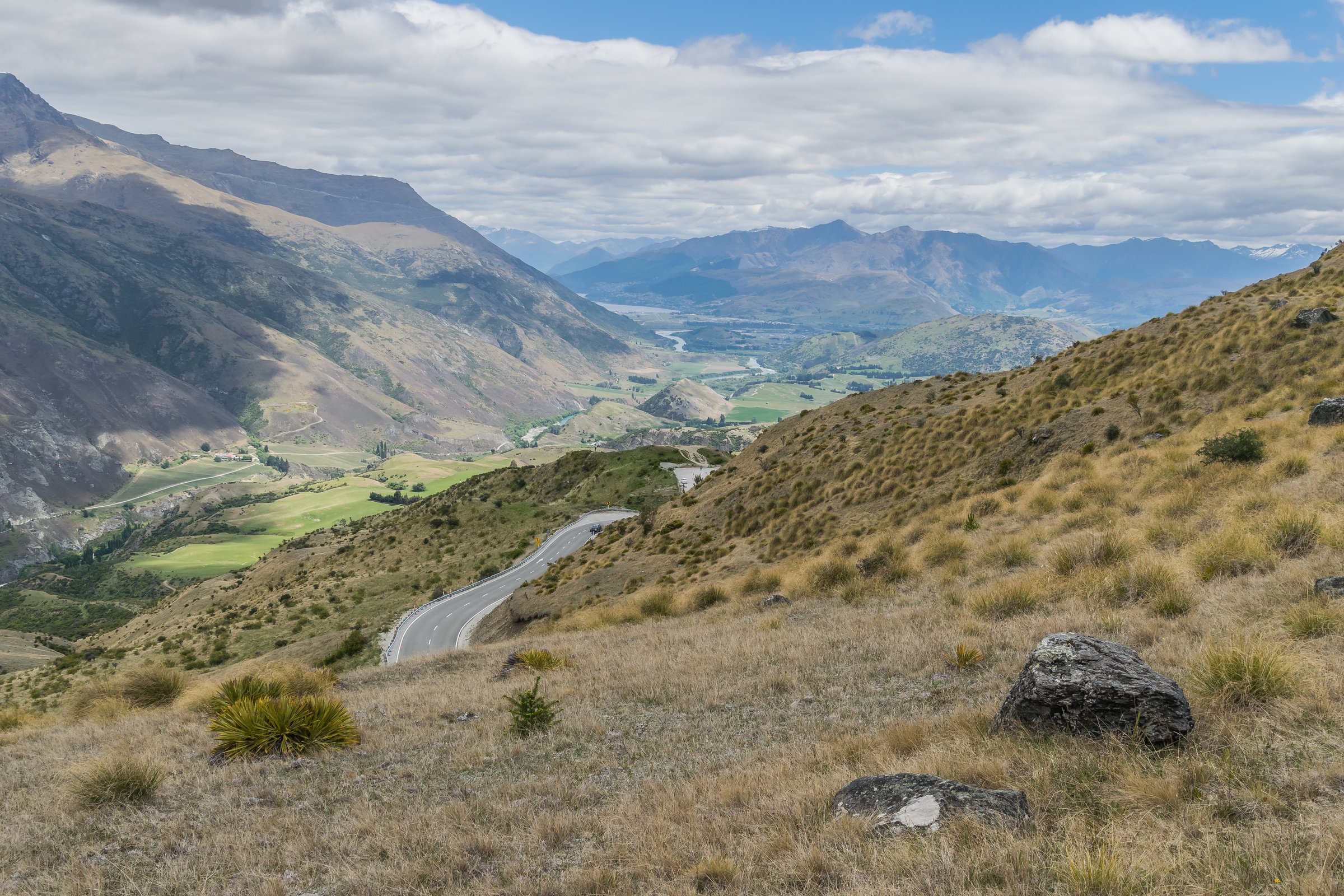
Walking here is dry, exposed Central Otago high country: farm easements, steep 4WD access tracks, kanuka and totara remnants, open tussock, schist tors, alpine tarn country around Lake McKay, and long views across the Upper Clutha Basin. The main public approaches are Queensberry car park, Locharburn Track, and the lower Luggate Creek access.
The normal hiking season is late spring to autumn. DOC warns that snow commonly affects the tops from May to November, avalanche terrain can cross tracks, water is unreliable, and hot dry summer conditions are common. Most access routes cross private land; stay on marked tracks, leave gates as found, and check current DOC notes before departure.
Selection rationale
The five hikes below represent the northern side’s legal public access and landscape range: the main Queensberry day objective, the Locharburn access route, the long northern ridge and Lake McKay objectives, and the low-level Luggate Creek connector. The Lake McKay and full-ridge entries remain conservative because official sources describe them as parts of the larger Pisa Range Ridge Track rather than separate day-walk products.
Summary table
| # | Hike | Country | Route type | Distance | Gain | Max elevation | Difficulty |
|---|---|---|---|---|---|---|---|
| 1 | Pt 1,444 Trig from Queensberry | New Zealand | Out-and-back | 15 km | Not stated by DOC | 1,444 m | Advanced |
| 2 | Locharburn Track to Pisa Ridge | New Zealand | Out-and-back | 13.36 km | Not stated by DOC | Intermediate | |
| 3 | Queensberry to Lake McKay Viewpoint | New Zealand | Out-and-back | Approx. 28 km return if using Snow Farm’s 14 km one-way figure | Lake McKay approx. 1,852 m from OSM/Mapcarta | Hard | |
| 4 | Pisa Range Ridge Track from Queensberry | New Zealand | Long point-to-point traverse | 29.24 km one way | 1,963 m at Mt Pisa | Hard | |
| 5 | Luggate Creek Track | New Zealand | Out-and-back / connector | 3 km return | Minimal; not stated by DOC | Easy |
1. Pt 1,444 Trig from Queensberry
Snapshot
Itinerary
From Queensberry car park, the route follows the Pisa Range Ridge Track through farmland and past Alfern Creek Conservation Area before crossing the stile into Pisa Conservation Area. The farm track then continues steadily to the trig at 1,444 m. The return follows the same route.
Why it is essential
This is the clearest official day walk from the northern/eastern Pisa access system. It gives a manageable introduction to the Queensberry approach and views across the Upper Clutha Basin without committing to the full ridge traverse.
Equipment
- Sturdy boots
- Windproof and waterproof layers
- Warm layer
- Sun protection
- Food
- Water
- Map/GPS
- Navigation backup
- Headtorch for slow parties
Hazards and notes
- DOC warns of hot, dry summer conditions, rapid weather change, whiteout and hypothermia risk.
- Avalanche terrain when snow is present.
- Private-land easement rules; no dogs on this access.
- No facilities on the track; water should not be relied on.
GPX / KML links
| Source | URL | Format / access | Reuse status |
|---|---|---|---|
| DOC Pt 1,444 Trig | doc.govt.nz | Official route page / map source | DOC terms; route geometry reuse not stated; source-map reference only |
| Plan My Walk: Pisa Range Ridge Track | planmywalk.nz | Secondary map source | Terms not checked; source-map reference only |
External links
2. Locharburn Track to Pisa Ridge
Snapshot
Itinerary
The Locharburn Track follows a steep fence line through Locharburn Scenic Reserve and then reaches a farm road leading to Pisa Conservation Area. The route links with the Pisa Ridge and can be used to continue toward Lake McKay or Mt Pisa, but the standard day walk returns by the same line.
Why it is essential
Locharburn is the northern range’s most direct official access from the east. It provides a steep, less-developed alternative to Queensberry and shows the remnant shrubland and private-easement character of the Pisa foothills.
Equipment
- Sturdy boots
- Warm and waterproof layers
- Sun protection
- Water
- Food
- Map/GPS and navigation backup
- Trekking poles useful on the steep fence-line sections
Hazards and notes
- DOC states that the route crosses private land.
- Closes for lambing from 1 October to 31 October.
- No obvious trailhead signs or car park.
- Unsuitable for dogs without landowner permission.
- Snow, whiteout, severe wind and avalanche terrain are seasonal concerns.
GPX / KML links
| Source | URL | Format / access | Reuse status |
|---|---|---|---|
| DOC Locharburn Track | doc.govt.nz | Official route page / map source | DOC terms; route geometry reuse not stated; source-map reference only |
| OpenStreetMap search | openstreetmap.org | OSM map/search | OSM data is ODbL; geometry cross-check only |
External links
3. Queensberry to Lake McKay Viewpoint
Snapshot
Itinerary
From Queensberry, follow the Pisa Range Ridge Track past Pt 1,444 and continue along the ridge toward Lake McKay. DOC describes Lake McKay as one of the scenic highlights on the Pisa Range Ridge Track. The return follows the same exposed ridge route.
Why it is essential
Lake McKay is one of the northern Pisa tops’ defining landscape features. This entry records it as a major day objective, but the route needs GPX measurement before publication because official sources do not isolate it as a standard day walk.
Equipment
- Sturdy boots
- Windproof and waterproof layers
- Warm layer
- Sun protection
- At least 2-3 litres of water
- Food
- Map/GPS and navigation backup
- Headtorch
- Emergency shelter
- Distress beacon recommended
Hazards and notes
- Long, exposed and water-poor.
- DOC warns of unreliable water, no facilities, severe wind, whiteout and hypothermia risk.
- Private land on the approach; no dogs via Queensberry.
- Avalanche terrain when snow is present.
GPX / KML links
| Source | URL | Format / access | Reuse status |
|---|---|---|---|
| DOC Pisa Range Ridge Track | doc.govt.nz | Official route page / map source | DOC terms; route geometry reuse not stated; source-map reference only |
| Snow Farm Pisa hiking and biking trails | snowfarm.nz | Local route notes | Terms not checked; distance/context only |
| Backpack New Zealand: Pisa Range Ridge Track map | backpack-newzealand.com | Secondary map with KML/GPX/TCX download buttons | Source states downloads; reuse terms not checked; secondary route-file source only |
External links
- DOC — Pisa Range Ridge Track
- Snow Farm NZ — Pisa hiking and biking trails
- Mapcarta — Lake McKay reference
4. Pisa Range Ridge Track from Queensberry
Snapshot
Itinerary
The route climbs from Queensberry through farmland and Alfern Creek Conservation Area, reaches Pt 1,444, continues past the Locharburn junction and Lake McKay, then veers toward Mt Pisa. South of Mt Pisa it follows the broad ridgeline past the Tinwald Burn junction, Column Rocks and Mt Dottrel before ending at the public conservation boundary.
Why it is essential
This is the main northern-to-central spine route of the Pisa Range and the route that connects the northern access tracks with Mt Pisa, Lake McKay, Tinwald Burn and the wider conservation area.
Equipment
- Sturdy boots
- Windproof/waterproof layers
- Warm layer
- Gloves/hat outside midsummer
- Sun protection
- Map/GPS and navigation backup
- Headtorch
- Emergency shelter
- High water capacity
- Distress beacon recommended
Hazards and notes
- DOC explicitly warns that there is no exit on the Mitre Rocks / Lowburn side and that earlier mapped links to Deep Creek via Mitre Rocks crossed private land.
- Visitors must stay on public conservation land and use legal exits.
- Water is unreliable.
- Weather is severe on the ridge.
- Winter/spring snow creates avalanche exposure.
GPX / KML links
| Source | URL | Format / access | Reuse status |
|---|---|---|---|
| DOC Pisa Range Ridge Track | doc.govt.nz | Official route page / map source | DOC terms; route geometry reuse not stated; source-map reference only |
| Trailforks: Pisa Range Ridge Track (DOC) | trailforks.com | Secondary route page; login-gated GPX/KML noted | Trailforks terms apply; secondary source only |
| Backpack New Zealand: Pisa Range Ridge Track map | backpack-newzealand.com | Secondary map with KML/GPX/TCX download buttons | Reuse terms not checked; secondary route-file source only |
External links
- DOC — Pisa Range Ridge Track
- Plan My Walk — Pisa Range Ridge Track
- Trailforks — Pisa Range Ridge Track (DOC)
5. Luggate Creek Track
Snapshot
Itinerary
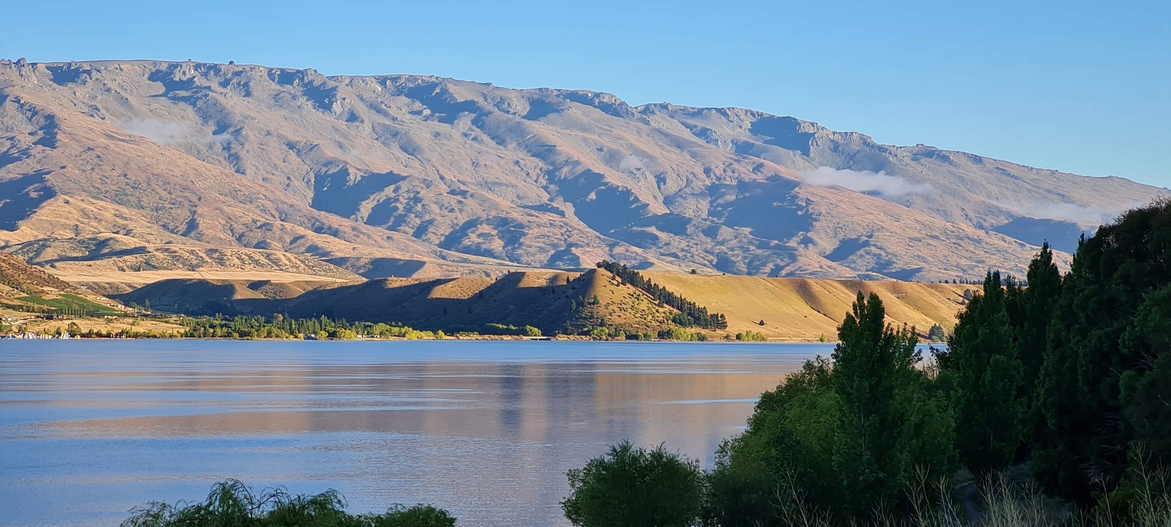
The track follows Luggate Creek from the township toward the Clutha River / Mata-Au, passing creekside willow-lined sections before joining the Upper Clutha River Track. It can be walked as a short out-and-back or used as a low-level connector.
Why it is essential
This is the northern Pisa area’s accessible low-level walk and a useful contrast to the exposed ridge routes. It is not a mountain tramp, but it gives legal public walking access in the Luggate Creek catchment at the northern end of the range.
Equipment
- Comfortable walking shoes
- Water
- Sun protection
- Weather layer
Hazards and notes
- Dogs must be on a leash.
- Shared-use walking and cycling track; follow shared-track etiquette.
- Does not provide alpine access and should not be treated as a substitute for the high Pisa routes.
GPX / KML links
| Source | URL | Format / access | Reuse status |
|---|---|---|---|
| DOC Luggate Creek Track | doc.govt.nz | Official route page / map source | DOC terms; route geometry reuse not stated; source-map reference only |
| AllTrails: Luggate Creek Track | alltrails.com | Secondary route page / app map | AllTrails terms apply; GPX export terms not verified; source-map reference only |
External links
Missing data / follow-up work
- Elevation gain/loss is not published by DOC for Pt 1,444, Locharburn, Lake McKay or the full Pisa Range Ridge Track.
- Lake McKay as a day objective needs GPX measurement; official sources describe it within the longer ridge track.
- No official downloadable GPX was found for the northern routes; secondary KML/GPX sources need terms review.
- DOC credits the Luggate Creek image as Creative Commons, but the exact licence was not resolved.
- Current lambing closures, private-land easement conditions and avalanche forecasts need confirmation before use.
External links
| Source | URL |
|---|---|
| DOC — Pisa Conservation Area | doc.govt.nz |
| DOC — Pt 1,444 Trig | doc.govt.nz |
| DOC — Locharburn Track | doc.govt.nz |
| DOC — Pisa Range Ridge Track | doc.govt.nz |
| DOC — Luggate Creek Track | doc.govt.nz |
| Plan My Walk — Pisa Range Ridge Track | planmywalk.nz |
| Snow Farm NZ — Pisa hiking and biking trails | snowfarm.nz |
| Trailforks — Pisa Range Ridge Track (DOC) | trailforks.com |
| Backpack New Zealand — Pisa Range Ridge Track map | backpack-newzealand.com |
| AllTrails — Luggate Creek Track | alltrails.com |
| Mapcarta — Lake McKay reference | mapcarta.com |