Regional overview
The Hump Ridge area sits in southern Fiordland around Tuatapere, Te Waewae Bay, Lake Hauroko, Waitutu Forest, and the Tuatapere Hump Ridge Track. It is a mountain-to-coast landscape: podocarp forest, exposed coastline, subalpine ridge, boardwalked tarns and tors, old tramways, and the Port Craig timber-milling heritage sites.
The Hump Ridge Track became New Zealand’s 11th Great Walk on 25 October 2024. It is still operated in partnership with the Tuatapere Hump Track Charitable Trust, and its lodges and track packages are booked through the Trust rather than with standard DOC hut passes. The nearby South Coast Track and Lake Hauroko routes remain more traditional DOC tramping terrain.
Access is via Tuatapere, Rarakau car park near Bluecliffs Beach, and the Lillburn Valley Road to Lake Hauroko. Weather can change quickly, coastal sections are tide- and surge-sensitive, and the ridge can be cold, windy, wet, or clouded in even in summer.
Selection rationale
The five selections cover the Hump Ridge area’s essential day-walk experiences: the high Great Walk approach to Okaka Lodge, the Okaka tops loop, the South Coast day walk to Te Waewae Bay, the Lake Hauroko lookout, and the Port Craig viaduct heritage day section.
Summary table
| # | Hike | Country | Route type | Distance | Gain | Max elevation | Difficulty | Photo status |
|---|---|---|---|---|---|---|---|---|
| 1 | Hump Ridge Track: Rarakau car park to Okaka Lodge | New Zealand | Point-to-point Great Walk day section | 19.6-20.6 km depending on source | 1,110 m on AllTrails | ca. 978 m near Okaka tops | Hard | Open DOC blog candidate found |
| 2 | Okaka Loop Walk | New Zealand | Loop / heli-assisted or lodge side trip | 45 min | ca. 978 m | Easy-moderate but access-dependent | Open DOC blog candidate found | |
| 3 | South Coast Track: Rarakau car park to Te Waewae Bay beach | New Zealand | Out-and-back | 6.2 km return | Low coastal route | Easy-moderate | Open DOC image candidate found | |
| 4 | Lake Hauroko Lookout Track | New Zealand | Out-and-back | 5.3-5.8 km return depending on source | 386 m on AllTrails | Hard / steep tramping track | Open DOC image candidate found | |
| 5 | Port Craig to Percy Burn / Sand Hill Viaducts | New Zealand | Out-and-back day section | Distance unresolved; 4 hr return by DOC time to viaducts | Moderate-advanced, access-dependent | Open DOC/South Coast candidate found |
1. Hump Ridge Track: Rarakau car park to Okaka Lodge
Snapshot
Itinerary
From Rarakau car park, the Hump Ridge Track begins along the South Coast Track beside Te Waewae Bay, crossing Waikou River, Hump Burn, Waikoko Stream, and Pipi Tuaraki/Flat Creek. Shortly after Flat Creek, the route turns inland onto the Hump Ridge Track and climbs from coastal forest into mountain beech and then subalpine terrain.
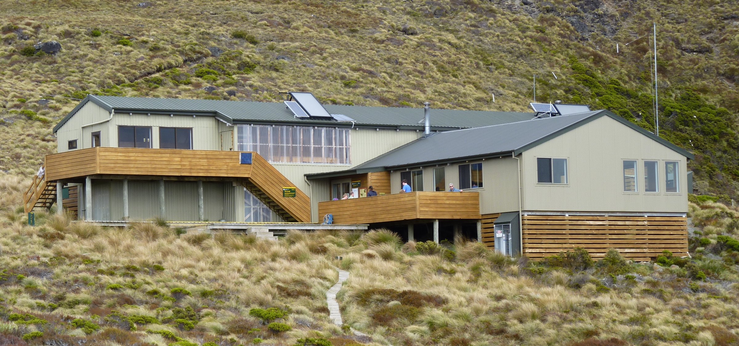
Okaka Lodge sits above the tree line in a protected amphitheatre below the Hump Ridge tops. As a day-hike catalogue entry, this is best treated as day one of a booked Great Walk itinerary, or as a heli/transport-supported objective arranged through the Trust.
Why it is essential
This is the signature climb of the Hump Ridge area: ocean to subalpine ridge in a single day, linking coastal forest, beaches, boardwalk, tors, tarns, and broad southern Fiordland views.
Equipment
- Mountain hiking equipment: boots, full waterproofs, warm layers, hat/gloves, food, water, headtorch, and first-aid kit.
- Carry all equipment required by the Hump Ridge Track booking/operator information.
- Pack for cold wind and low cloud on the ridge even in summer.
Hazards and notes
- DOC states the track requires moderate to high fitness and 7-9 hr walking days.
- Coastal sections have tidal surge, rogue wave, rockfall, landslide, and tsunami hazards.
- Ridge sections can be exposed to high wind, low cloud, rain, and cold temperatures.
- Bookings and fees are through the Hump Ridge Trust; DOC hut passes cannot be used for the private lodges.
- No dogs, no mountain bikes, no quad bikes, and no unauthorised drones.
Photos
| Image | Source | Author | Licence | Reuse notes | Attribution |
|---|---|---|---|---|---|
| Looking south from above Okaka Lodge | blog.doc.govt.nz | DOC | CC BY 4.0 under DOC copyright terms for DOC-labelled images | Commercial reuse and modification appear allowed with attribution; DOC logos/design excluded | “Looking South from above Okaka Lodge” by Department of Conservation (NZ), CC BY 4.0 |
GPX / KML links
| Source | URL | Format | Licence / terms | Reuse status |
|---|---|---|---|---|
| DOC: Hump Ridge Track | doc.govt.nz | Official route page / source map | DOC and Hump Ridge Trust terms; no GPX located on page | Official source checked; downloadable route file not found |
| AllTrails: Hump Ridge Track: Rarakau Carpark to Okaka Lodge | alltrails.com | Source route page / GPX via service | AllTrails terms apply | Secondary route source found; reuse not confirmed |
External links
- DOC — Hump Ridge Track
- DOC blog — Hump Ridge Track background
- AllTrails — Hump Ridge Track: Rarakau Carpark to Okaka Lodge
2. Okaka Loop Walk
Snapshot
Itinerary
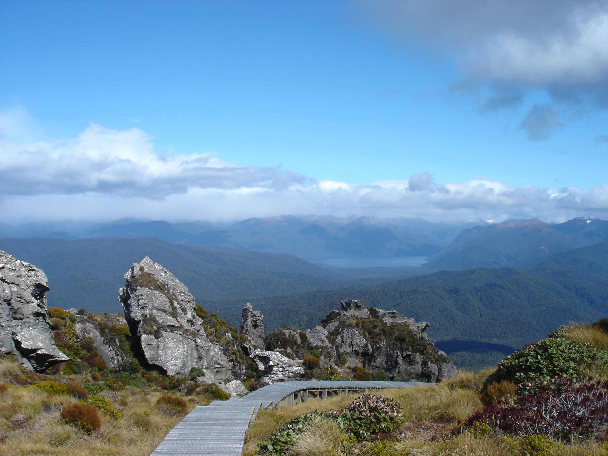
The Okaka Loop Walk is a short boardwalk loop from Okaka Lodge around tors and tarns on Hump Ridge. DOC describes 360-degree views over Western Southland from this side trip.
Although the loop itself is short, getting there is not. It is normally walked after reaching Okaka Lodge on the Hump Ridge Track, or as part of a heli-assisted option arranged through the Hump Ridge operator.
Why it is essential
The loop is the most concentrated Hump Ridge tops experience: boardwalk, tarns, limestone tors, subalpine vegetation, and wide coastal/mountain views in less than an hour of walking.
Equipment
- Standard hiking equipment for the loop if already based at Okaka Lodge.
- Warm windproof and waterproof layers are essential because the ridge is exposed.
- If arriving via the full Hump Ridge approach, carry full Great Walk overnight equipment.
Hazards and notes
- Do not underestimate the loop because of its short time: cloud, wind, rain, and cold can arrive quickly.
- Stay on boardwalks where provided to protect fragile subalpine ground.
- Helicopter landing zones must be avoided unless instructed by operators.
- Access, fees, and bookings are controlled through the Hump Ridge Track operator.
Photos
| Image | Source | Author | Licence | Reuse notes | Attribution |
|---|---|---|---|---|---|
| View from the lookout toward Luncheon Rock / Hump Ridge tops | blog.doc.govt.nz | DOC | CC BY 4.0 under DOC copyright terms for DOC-labelled images | Commercial reuse and modification appear allowed with attribution; DOC logos/design excluded | Department of Conservation (NZ), CC BY 4.0 |
GPX / KML links
| Source | URL | Format | Licence / terms | Reuse status |
|---|---|---|---|---|
| DOC: Hump Ridge Track, Okaka loop side trip | doc.govt.nz | Official route page / source map | DOC/Hump Ridge Trust terms; no GPX located on page | Official source checked; downloadable route file not found |
External links
3. South Coast Track: Rarakau car park to Te Waewae Bay beach
Snapshot
Itinerary
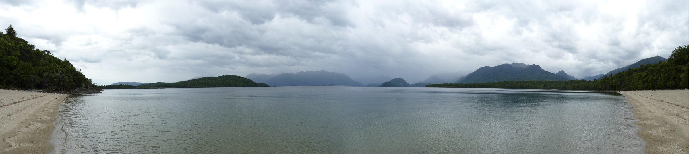
From Rarakau car park, follow the South Coast Track through lush rainforest to steep steps descending from the bush. The route then crosses a terrace above Te Waewae Bay and reaches the swing bridge over the Waikoau River. Beyond the whitebaiters’ baches the track reaches the beach.
This short out-and-back is the most practical day walk for sampling the Hump Ridge/South Coast coastline without committing to the full Great Walk or overnight South Coast Track.
Why it is essential
It gives immediate access to the coastline that defines the Hump Ridge area: forest, swing bridge, beach, sea views, and the chance of marine wildlife sightings in Te Waewae Bay.
Equipment
- Standard hiking equipment: hiking shoes, waterproof layer, warm layer, water, snacks, sun protection, and insect repellent.
- Check tide, swell, and weather conditions before extending along the coast.
Hazards and notes
- Coastal sections can be affected by tidal surge, rogue waves, and slippery driftwood or stones.
- The longer South Coast Track has muddy sections, unbridged streams, and more remote hazards.
- No dogs are allowed.
Photos
| Image | Source | Author | Licence | Reuse notes | Attribution |
|---|---|---|---|---|---|
| South Coast Track | doc.govt.nz | Amy Stewart-Badger / DOC | CC BY 4.0 under DOC copyright terms for DOC-labelled images | Commercial reuse and modification appear allowed with attribution; DOC logos/design excluded | “South Coast Track” by Amy Stewart-Badger, Department of Conservation (NZ), CC BY 4.0 |
| Hector’s dolphin / Te Waewae Bay day-walk brochure image | doc.govt.nz | DOC | CC BY 4.0 for DOC-labelled brochure images unless otherwise credited | Commercial reuse and modification appear allowed with attribution; verify individual caption before publication | Department of Conservation (NZ), CC BY 4.0 |
GPX / KML links
| Source | URL | Format | Licence / terms | Reuse status |
|---|---|---|---|---|
| DOC: South Coast Track | doc.govt.nz | Official route page / source map | DOC terms; no GPX located on page | Official source checked; downloadable route file not found |
| DOC Fiordland Day Walks brochure | doc.govt.nz | PDF map and day-walk guide | DOC terms | Official day-walk source found; no GPX found |
External links
4. Lake Hauroko Lookout Track
Snapshot
Itinerary
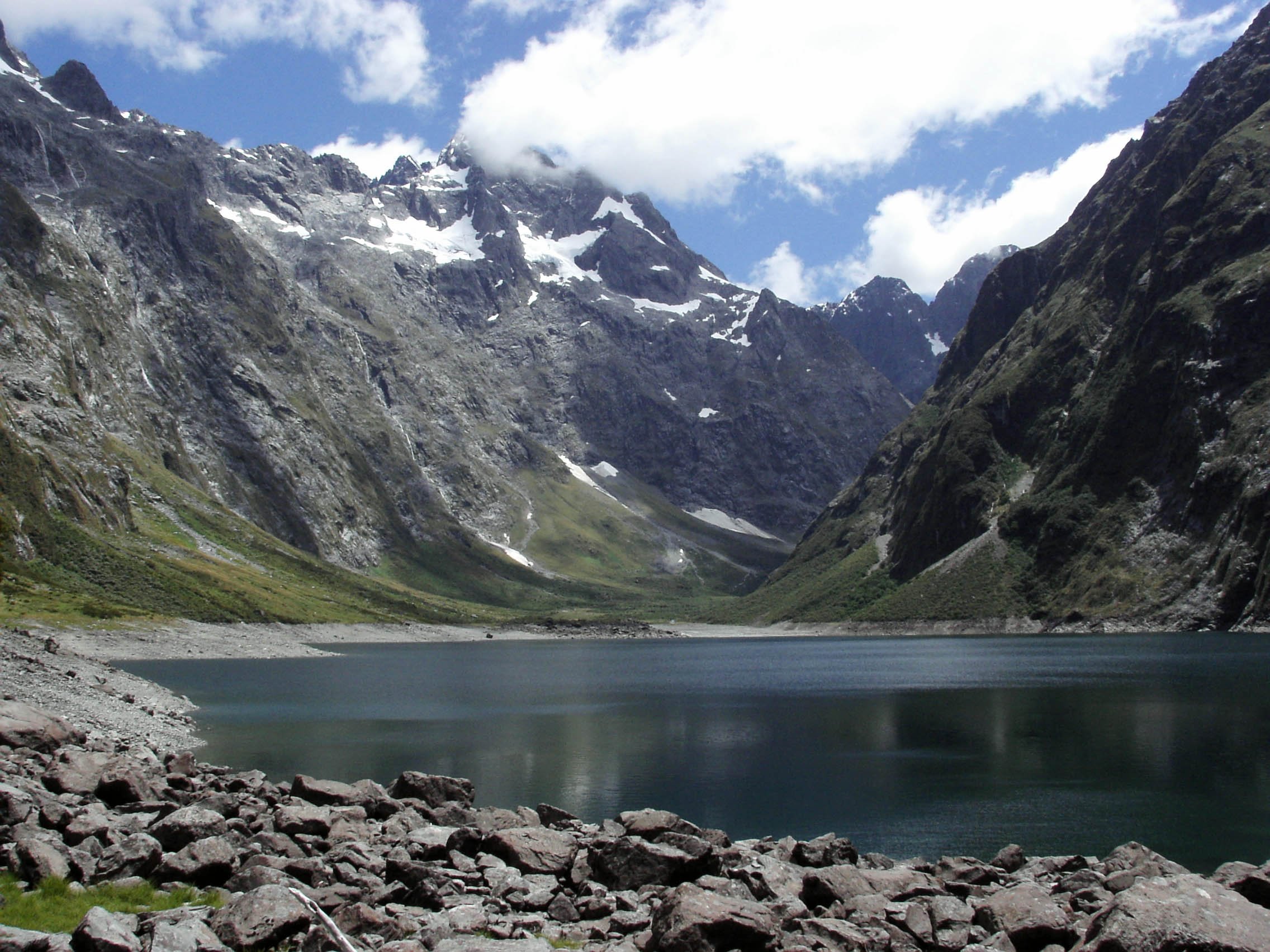
The track starts near Lake Hauroko and follows the lake edge before climbing steeply through forest to a lookout. In clear weather, views extend over Lake Hauroko, Foveaux Strait, the Takitimu Mountains, and the Princess and Kaherekoau mountains.
Why it is essential
Lake Hauroko is one of southern Fiordland’s defining features and New Zealand’s deepest lake. The lookout is the most accessible elevated day route in the Lake Hauroko/Hump Ridge area.
Equipment
- Mountain hiking equipment for a short but steep track: boots, waterproofs, warm layer, water, food, and poles.
- Carry insect repellent and navigation backup.
Hazards and notes
- DOC describes the track as steep and rough.
- Lake Hauroko can be affected by strong wind and rapid weather change.
- The access road has a long unsealed section.
- The wider Lake Hauroko area is culturally significant; keep to tracks and respect local guidance.
Photos
| Image | Source | Author | Licence | Reuse notes | Attribution |
|---|---|---|---|---|---|
| View down to Lake Hauroko from lookout | doc.govt.nz | Olivia Graham / DOC | CC BY 4.0 under DOC copyright terms for DOC-labelled images | Commercial reuse and modification appear allowed with attribution; DOC logos/design excluded | “View down to Lake Hauroko” by Olivia Graham, Department of Conservation (NZ), CC BY 4.0 |
GPX / KML links
| Source | URL | Format | Licence / terms | Reuse status |
|---|---|---|---|---|
| DOC: Lake Hauroko Lookout Track | doc.govt.nz | Official route page / source map | DOC terms; no GPX located on page | Official source checked; downloadable route file not found |
| AllTrails: Lake Hauroko Lookout Track | alltrails.com | Source route page / GPX via service | AllTrails terms apply | Secondary source found; reuse not confirmed |
External links
- DOC — Lake Hauroko Lookout Track
- DOC — Southern Fiordland tracks brochure
- AllTrails — Lake Hauroko Lookout Track
5. Port Craig to Percy Burn / Sand Hill Viaducts
Snapshot
Itinerary
From Port Craig, follow the South Coast Track south-west along the old logging tramline. DOC notes that the Sand Hill and Percy Burn viaducts are reached after about 2 hr of walking from Port Craig. Return by the same route.
This is not a normal road-end day walk. It is included because the viaducts and Port Craig timber-milling landscape are among the Hump Ridge area’s defining historic features.
Why it is essential
The Port Craig viaducts are the key cultural and historic walking objective of the Hump Ridge/South Coast area, preserving the old tramway landscape that shaped the region before conservation and recreation became its main public story.
Equipment
- Standard to mountain hiking equipment, depending on weather: boots, waterproofs, warm layer, water, food, headtorch, and map/GPS.
- Carry emergency shelter if walking from remote accommodation or during unstable weather.
Hazards and notes
- Access to Port Craig requires advance planning; Port Craig Lodge is private and DOC hut/lodge booking arrangements differ.
- Coastal and forest tracks can be muddy and affected by storms.
- The longer South Coast Track includes remote tramping hazards beyond this day section.
- Respect historic structures and do not climb on unsafe relics.
Photos
| Image | Source | Author | Licence | Reuse notes | Attribution |
|---|---|---|---|---|---|
| South Coast Track / Port Craig candidate | doc.govt.nz | Amy Stewart-Badger / DOC | CC BY 4.0 under DOC copyright terms for DOC-labelled images | Commercial reuse and modification appear allowed with attribution; exact viaduct-specific reusable image not isolated | “South Coast Track” by Amy Stewart-Badger, Department of Conservation (NZ), CC BY 4.0 |
GPX / KML links
| Source | URL | Format | Licence / terms | Reuse status |
|---|---|---|---|---|
| DOC: South Coast Track | doc.govt.nz | Official route page / source map | DOC terms; no GPX located on page | Official source checked; downloadable route file not found |
| DOC Southern Fiordland tracks brochure | doc.govt.nz | PDF route guide and map | DOC terms | Source map found; no GPX found |
External links
- DOC — South Coast Track
- DOC — Southern Fiordland tracks brochure
- South Coast Track — transport and options context
Missing data and follow-up
- Okaka Loop Walk and Port Craig viaduct distances were not resolved from official sources in this pass.
- Several Hump Ridge objectives are not normal standalone day walks; they require lodge booking, operator transport, helicopter option, or an overnight base.
- No official DOC GPX files were found for these routes in this pass.
- Hump Ridge Trust booking terms, fees, transport, and lodge access must be checked before publication.
- Tide, swell, coastal hazard, and weather information should be checked immediately before any South Coast route.
External links
| Source | URL |
|---|---|
| DOC — Hump Ridge Track | doc.govt.nz |
| DOC — Tuatapere area | doc.govt.nz |
| DOC — South Coast Track | doc.govt.nz |
| DOC — Lake Hauroko Lookout Track | doc.govt.nz |
| DOC — Fiordland Day Walks brochure | doc.govt.nz |
| DOC — Southern Fiordland tracks brochure | doc.govt.nz |
| DOC blog — Hump Ridge background | blog.doc.govt.nz |
| DOC — copyright and image reuse | doc.govt.nz |
| Visit Fiordland — Hump Ridge Track | fiordland.org.nz |
| AllTrails — Hump Ridge Track: Rarakau Carpark to Okaka Lodge | alltrails.com |
| AllTrails — Lake Hauroko Lookout Track | alltrails.com |
| South Coast Track — transport and options context | southcoasttrack.co.nz |