Regional overview
This entry treats Central Himalaya as the main Nepal Himalaya trekking regions where classic single-day objectives are reached from established teahouse bases. These are not all drive-up day hikes; several require multi-day approach treks before the day-hike stage begins.
The terrain is high-altitude Himalayan walking: sunrise viewpoints, glacial valleys, moraine ridges, alpine yak pastures, and steep acclimatisation climbs. Spring and autumn are the normal trekking seasons. Winter brings snow and cold, while the monsoon brings cloud, leeches at lower elevations, landslides, and transport disruption.
Altitude is the dominant safety issue. Even non-technical hikes such as Gokyo Ri and Kyanjin Ri reach elevations where acute mountain sickness is possible. Local permit, guide, conservation-area, and national-park rules must be checked before travel.
Selection rationale
The five hikes were selected to represent Annapurna sunrise viewpoints, Annapurna ridge trekking, Langtang high viewpoints, Khumbu glacier/lake views, and a classic Everest-region acclimatisation walk.
Summary table
| # | Hike | Country | Route type | Distance | Gain | Max elevation | Difficulty |
|---|---|---|---|---|---|---|---|
| 1 | Poon Hill from Ghorepani | Nepal | Out-and-back | c. 3-5 km, not official | c. 336 m | 3,210 m | Moderate |
| 2 | Mardi Himal High Camp to Base Camp / Viewpoint | Nepal | Out-and-back | Unresolved | c. 950 m | c. 4,500 m | Hard |
| 3 | Kyanjin Ri from Kyanjin Gompa | Nepal | Loop / out-and-back variant | 4.5 km | 702 m | c. 4,700-4,773 m | Hard |
| 4 | Gokyo Ri from Gokyo | Nepal | Out-and-back | c. 3.5-5 km | c. 607 m | 5,357 m | Hard |
| 5 | Namche - Everest View - Khumjung loop | Nepal | Loop | c. 8-10 km, not official | Unresolved | c. 3,880 m | Moderate-hard |
1. Poon Hill from Ghorepani

Snapshot
Itinerary
The route climbs before dawn from Ghorepani to the Poon Hill viewpoint, then returns by the same trail. The viewpoint overlooks the Annapurna and Dhaulagiri massifs and is commonly walked as the sunrise stage of the Ghorepani trek.
Why it is essential
Poon Hill is Nepal’s classic short Himalayan sunrise viewpoint and one of the most accessible high-panorama walks in the Annapurna region.
Equipment
Standard hiking equipment, warm layer, headtorch, gloves/hat in cool season, and rain layer.
Hazards and notes
The ascent is short but at altitude. The trail is busy at sunrise. Annapurna Conservation Area permit rules apply to the wider approach trek.
GPX / KML links
| Source | URL | Format / access | Reuse status |
|---|---|---|---|
| No short official GPX found | — | — | Manual GPX creation needed |
External links
2. Mardi Himal High Camp to Base Camp / upper viewpoint

Snapshot
Itinerary
The day stage follows the open ridge above High Camp toward the Mardi Himal viewpoint and Base Camp area below Machhapuchchhre. The walking is non-technical in normal conditions but steep and fully exposed to weather.
Why it is essential
The Mardi Himal ridge gives close views of Machhapuchchhre and the Annapurna South/Hiunchuli wall and has become one of the defining shorter treks in the Annapurna region.
Equipment
Mountain hiking equipment, warm layer, windproof/waterproof shell, headtorch, sun protection, and enough water. Microspikes may be needed if snow or verglas remains.
Hazards and notes
Altitude, exposure, wind, snow, and poor visibility are the main hazards. Route distance and GPX remain unresolved and need a track source before final publication.
GPX / KML links
| Source | URL | Format / access | Reuse status |
|---|---|---|---|
| No public GPX/KML verified in this pass | — | — | Manual GPX creation needed |
External links
3. Kyanjin Ri from Kyanjin Gompa

Snapshot
Itinerary
The route climbs steeply from Kyanjin Gompa to the Kyanjin Ri viewpoint above the upper Langtang Valley. It can be walked as an acclimatisation summit after reaching the Kyanjin lodges.
Why it is essential
Kyanjin Ri is one of Langtang’s most accessible high viewpoints, with close views of Langtang Lirung, the Kyanjin basin, and surrounding glaciated peaks.
Equipment
Mountain hiking equipment, warm layer, windproof shell, sun protection, water, and trekking poles. Microspikes may be useful when snow remains.
Hazards and notes
The route gains height quickly. Strong wind, snow, and altitude symptoms can make the walk serious despite its short distance.
GPX / KML links
| Source | URL | Format / access | Reuse status |
|---|---|---|---|
| AllTrails — Kyanjin Gompa - Kyanjin Ri | alltrails.com | Source map / route page | AllTrails terms apply; source-map reference only |
External links
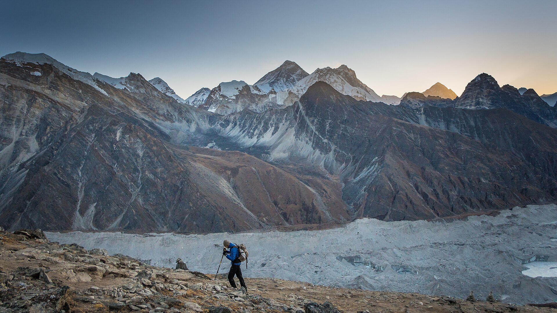
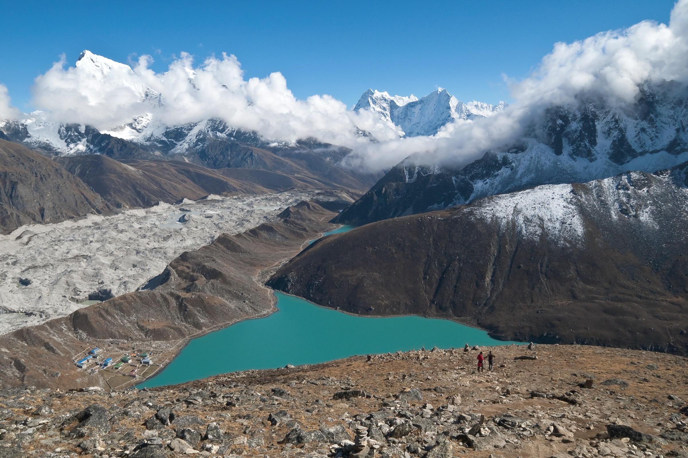
4. Gokyo Ri from Gokyo

Snapshot
Itinerary
The trail climbs directly from Gokyo village beside Dudh Pokhari to the summit of Gokyo Ri. The upper slope is steep but non-technical in normal dry conditions.
Why it is essential
Gokyo Ri is one of the finest non-technical viewpoints in the Everest region, with views over Gokyo Lakes, Ngozumpa Glacier, Cho Oyu, Everest, Lhotse, and Makalu in clear weather.
Equipment
Mountain hiking equipment, warm layer, windproof shell, sun protection, water, and headtorch for dawn ascents. Microspikes may be required in snow/ice.
Hazards and notes
The summit is above 5,000 m. Acclimatisation is essential. Wind, snow, and altitude illness can make the route serious.
GPX / KML links
| Source | URL | Format / access | Reuse status |
|---|---|---|---|
| No public GPX/KML verified in this pass | — | — | Manual GPX creation needed |
External links
5. Namche - Everest View - Khumjung loop

Snapshot
Itinerary
The acclimatisation loop climbs from Namche toward the Syangboche/Everest View area, then can continue toward Khumjung and Kunde before returning to Namche. The route uses established Khumbu trails and gives early views of Everest-region peaks.
Why it is essential
This is the classic Namche acclimatisation day and introduces Khumbu village landscapes, monasteries, stone walls, and high Himalayan views without pushing far up-valley.
Equipment
Standard to mountain hiking equipment, warm layer, rain shell, sun protection, water, and navigation backup.
Hazards and notes
Although lower than Gokyo/Kyanjin viewpoints, the route is still at altitude. Fog can reduce visibility. Exact route stats need a source track before publication.
GPX / KML links
| Source | URL | Format / access | Reuse status |
|---|---|---|---|
| No public GPX/KML verified in this pass | — | — | Manual GPX creation needed |
External links
External links
| Source | URL |
|---|---|
| AllTrails — Kyanjin Gompa to Kyanjin Ri | alltrails.com |
| Wikipedia — Poon Hill | en.wikipedia.org |
| Wikipedia — Ghorepani | en.wikipedia.org |
| Wikipedia — Mardi Himal | en.wikipedia.org |
| Wikipedia — Langtang National Park | en.wikipedia.org |
| Wikipedia — Gokyo Ri | en.wikipedia.org |
| Wikipedia — Gokyo | en.wikipedia.org |
| Wikipedia — Namche Bazaar | en.wikipedia.org |
| Wikipedia — Khumbu | en.wikipedia.org |