Regional overview
This selection treats the Eastern Himalaya as a cross-border walking region: Bhutan’s monastery and high-pass forests, India’s Singalila/Sikkim rhododendron belt, and Nepal’s Kanchenjunga high-alpine approach. Goecha La was excluded as a full trek and Pangpema is used only as a one-day section from Lhonak.
Selection rationale
The five routes cover the most distinctive day-walking categories of the Eastern Himalaya: Bhutan’s cliff-monastery objective, a high-pass forest viewpoint, a rhododendron-and-Kanchenjunga ridge in Singalila, a Sikkim rhododendron sanctuary walk, and a single high-altitude moraine day from Lhonak to Pangpema.
Summary table
| # | Hike | Country | Route type | Distance | Gain | Max elevation | Difficulty |
|---|---|---|---|---|---|---|---|
| 1 | Tiger’s Nest / Paro Taktsang | Bhutan | Out-and-back | 7.2 km | 692 m | 3,193 m | Hard |
| 2 | Lungchuzekha from Dochula | Bhutan | Out-and-back | 6.6 km | 538 m | 3,584 m | Hard |
| 3 | Tonglu / Tumling Ridge Walk | India | Out-and-back | 10.9 km | 559 m | 3,041 m | Moderate |
| 4 | Hilley to Barsey Rhododendron Sanctuary | India | Out-and-back | ~8 km | Not verified | Not verified | Easy/Moderate |
| 5 | Lhonak to Pangpema / Kanchenjunga North BC | Nepal | Out-and-back | 15.8 km | 822 m | 5,154 m | Hard |
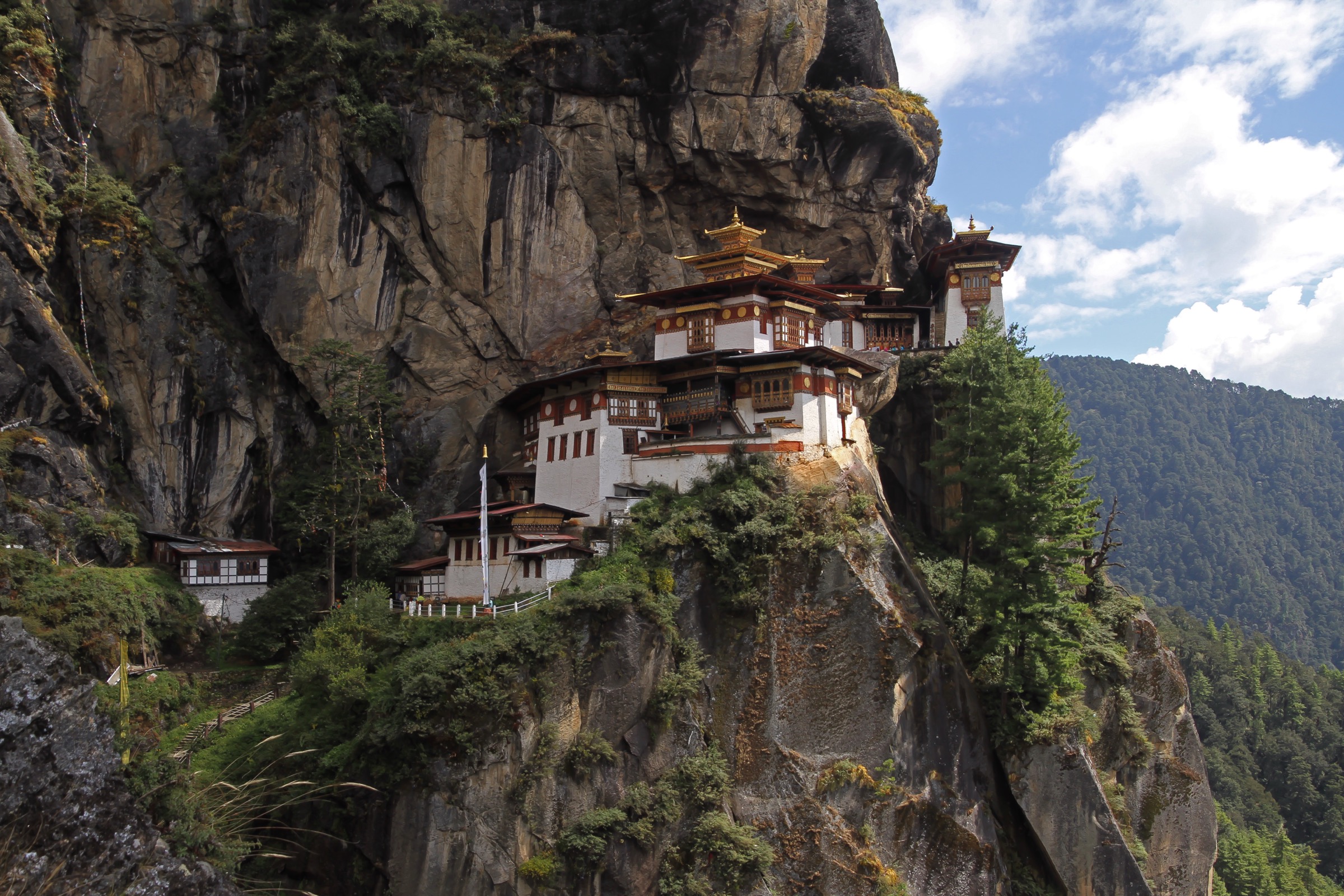
1. Tiger’s Nest / Paro Taktsang Trail

Snapshot
Itinerary
Climb through pine forest to the viewpoint/cafeteria, cross the stair-and-waterfall section, and visit the cliff monastery at about 3,120 m.
Why it is essential
Paro Taktsang is the defining Himalayan cliff-monastery walk and the single most recognised day objective in Bhutan.
Equipment
Boots, water, modest clothing for monastery; poles optional.
Hazards and notes
Steep stairs, crowds, and altitude if newly arrived are the main concerns.
GPX / KML links
| Source | URL | Format / access | Reuse status |
|---|---|---|---|
| AllTrails source map | alltrails.com | Source map | AllTrails terms; direct GPX not verified; route source only |
External links
- AllTrails — Tiger’s Nest Trail
- Paro Taktsang
- Wikimedia Commons — Bhutan-Paro-136-Taktshang-Tigernest.jpg
2. Lungchuzekha / Lungchutse Monastery Trail from Dochula

Snapshot
Itinerary
Forest and rhododendron climb from the Dochula/Lamperi area toward Lungchuzekha monastery, with Himalayan views in clear weather.
Why it is essential
This is the standard Dochula viewpoint day walk and the strongest sourced high-pass forest route in central Bhutan.
Equipment
Boots, warm layers, rain shell, snacks/water.
Hazards and notes
Thin air, mud, and cold fog are the main concerns; views depend heavily on clear-weather windows.
GPX / KML links
| Source | URL | Format / access | Reuse status |
|---|---|---|---|
| AllTrails source map | alltrails.com | Source map | AllTrails terms; direct GPX not verified; route source only |
External links
- AllTrails — Lungchutse Monastery Trail
- Dochula Pass
- Wikimedia Commons — Druk Wangyal Chortens, Bhutan 01.jpg
3. Tonglu / Tumling Ridge Walk

Snapshot
Itinerary
Rhododendron, pine, fir, and birch forest to the Singalila ridge with Kanchenjunga views and, in clear weather, Everest-range glimpses.
Why it is essential
The Tonglu/Tumling ridge is the classic Singalila day-walking section, combining the Sandakphu corridor’s rhododendron belt with Kanchenjunga panoramas.
Equipment
Boots, layers, permit/ID for park checks.
Hazards and notes
Fog, cold, road/trail overlap, and permits/checkposts require attention.
GPX / KML links
| Source | URL | Format / access | Reuse status |
|---|---|---|---|
| AllTrails source map | alltrails.com | Source map | AllTrails terms; direct GPX not verified; route source only |
External links
4. Hilley to Barsey Rhododendron Sanctuary

Snapshot
Itinerary
Short forest walk through the Barsey/Varsey Rhododendron Sanctuary to the Barsey hut/view area, best during flowering.
Why it is essential
This is the classic Sikkim rhododendron day walk and a key red-panda habitat landscape.
Equipment
Boots, rain shell, leech protection in wet season, water.
Hazards and notes
Mud, mist, and protected-area rules are the main concerns.
GPX / KML links
| Source | URL | Format / access | Reuse status |
|---|---|---|---|
| Route-file status | No GPX/KML found in this pass; access description per Varsey Rhododendron Sanctuary | Unresolved | Unresolved |
External links
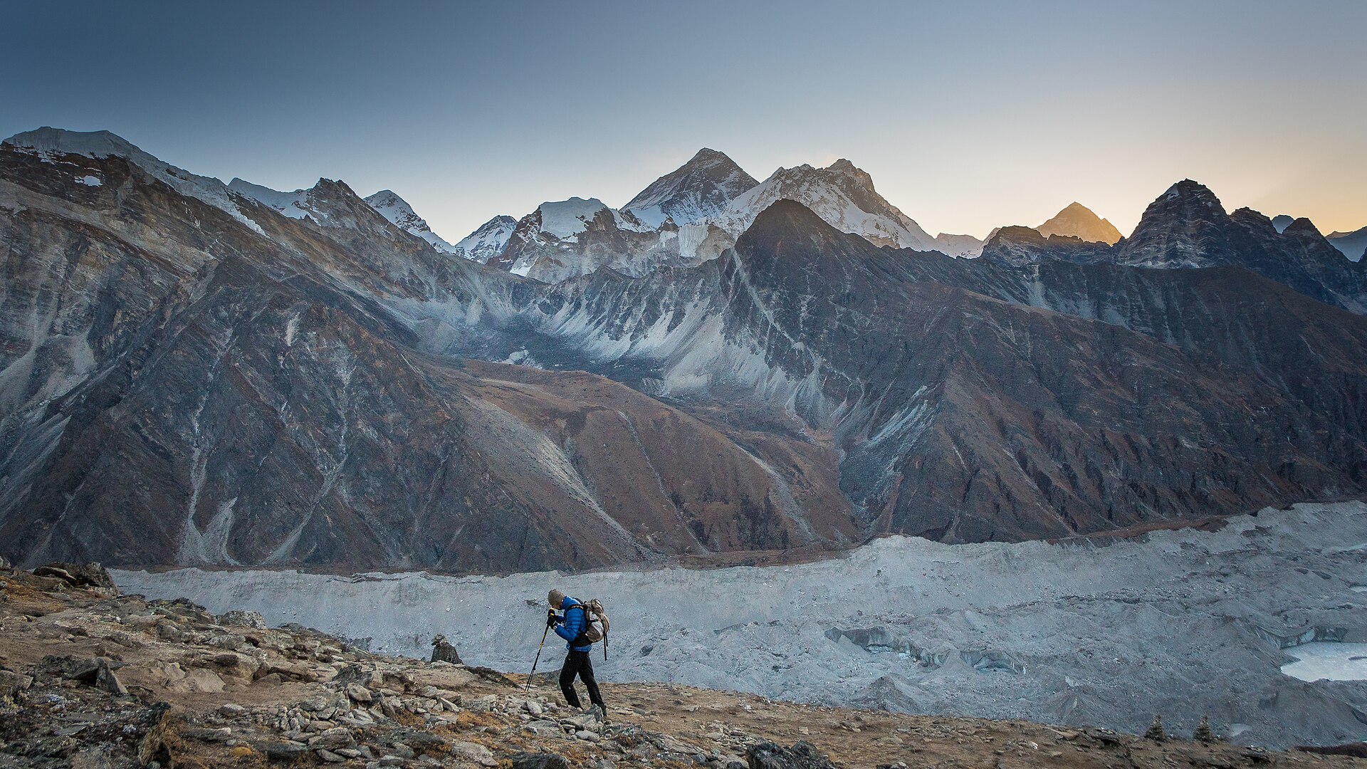
5. Lhonak to Pangpema / Kanchenjunga North Base Camp

Snapshot
Itinerary
High-alpine moraine route from Lhonak to Pangpema/North Base Camp viewpoint below Kangchenjunga, returning to Lhonak because Pangpema lacks standard lodging.
Why it is essential
Pangpema is the strongest day-distance Kangchenjunga viewpoint and represents the high-altitude end of the Eastern Himalaya day-walking spectrum.
Equipment
Full high-altitude trekking kit, poles, warm layers, purification, possibly microspikes depending on conditions.
Hazards and notes
Altitude illness, glacial debris, scarce water, and remoteness are the main concerns; KCAP and Restricted Area Permit are required.
GPX / KML links
| Source | URL | Format / access | Reuse status |
|---|---|---|---|
| AllTrails source map | alltrails.com | Source map | AllTrails terms; direct GPX not verified; route source only |
External links
- AllTrails — Lhonak to Pangpema
- Kanchenjunga Conservation Area
- Wikimedia Commons — Kangchenjunga PangPema.jpg
Missing data / follow-up work
- Direct GPX/KML downloads were not verified for any of the five routes; AllTrails was used as the source map only.
- Hilley-Barsey gain, loss, and maximum elevation remain unresolved in this pass.
- Tonglu/Tumling time was not stated by the route source and is estimated; point-to-point variants to Chitrey/Maneybhanjan need separate verification.
- Permit/fee details for Singalila NP, Barsey/Varsey Sanctuary, and KCAP should be confirmed before travel.
External links
| Resource | Link |
|---|---|
| Paro Taktsang | en.wikipedia.org |
| Dochula Pass | en.wikipedia.org |
| Singalila National Park | en.wikipedia.org |
| Varsey Rhododendron Sanctuary | en.wikipedia.org |
| Kanchenjunga Conservation Area | en.wikipedia.org |