Regional overview
The Black River Gorges, in the hilly south-western interior of Mauritius, form the island’s most important upland hiking landscape. The Black River Gorges National Park, proclaimed in 1994 and managed by the National Parks and Conservation Service (NPCS), covers roughly 67.5 km² of humid upland forest, drier lowland forest, and marshy heathland, and protects most of Mauritius’s surviving native rainforest. The park encloses the Rivière Noire mountain range, including Piton de la Petite Rivière Noire — at 828 m the highest summit in Mauritius — together with the Macchabée Ridge, the Brise Fer plateau, the upland savanna of Plaine Champagne, and the deeply incised valleys of the Rivière Noire and its tributaries.
Two NPCS information centres anchor the trail network: the Black River Visitor Centre on the western side (near the coast) and Le Pétrin on the eastern side, accessible from the B103 Plaine Champagne Road. The park advertises roughly 60 km of marked trails, including ridge balcony walks to the Macchabée Viewpoint, forest loops past the Mare aux Joncs waterfall, the cross-park Parakeet Trail linking Pétrin and Black River, and short panoramic walks from the Black River Gorges Viewpoint near Plaine Champagne. Outside the park boundary, the Tamarind (or Tamarin) Falls near Henrietta on the central plateau give the most spectacular waterfall day-walk in this part of the island. Trailheads are usually reached by private vehicle or organised tour. Some Black River trailheads have bus services from the coastal towns.
Best conditions are the cool, drier southern-hemisphere winter from May to October. The summer months (December to March) bring heavy rain, very high humidity, slippery rock, and tropical cyclones; trails to summits and waterfalls can be closed or genuinely dangerous after heavy rain. Park entry is free, but several routes including the upper Piton de la Petite Rivière Noire and the Tamarind Falls cascades are exposed, muddy, and use fixed ropes on the steepest sections — they should not be attempted in wet weather.
Selection rationale
The five entries combine the island’s highest summit (Piton de la Petite Rivière Noire), the classic forest-and-balcony route of the park (the Macchabée Viewpoint with the Mare aux Joncs loop), the longest park traverse showcasing the rainforest and endemic birdlife (the Parakeet Trail), the short panoramic walk at the most popular viewpoint (the Black River Gorges Viewpoint on Plaine Champagne), and the regional iconic waterfall hike (Tamarind Falls / Seven Cascades) on the central plateau just east of the park. They spread across both NPCS information centres and the central plateau, and cover a balanced mix of summit, balcony, traverse, viewpoint, and waterfall character.
Summary table
| # | Hike | Country | Route type | Distance | Gain | Max elevation | Difficulty |
|---|---|---|---|---|---|---|---|
| 1 | Piton de la Petite Rivière Noire from Plaine Champagne | Mauritius | Out-and-back | 6.9 km | 180 m | 828 m | Moderate |
| 2 | Macchabée Viewpoint and Mare aux Joncs loop (from Pétrin) | Mauritius | Loop | 9.9 km | 220 m | 670 m | Moderate |
| 3 | Parakeet Trail (Pétrin to Black River, or reverse) | Mauritius | Point-to-point | 6.5 km | 660 m | 660 m | Moderate |
| 4 | Black River Gorges Viewpoint walk (Plaine Champagne) | Mauritius | Out-and-back | 1 km | Negligible | 750 m | Easy |
| 5 | Tamarind Falls / Seven Cascades (from Henrietta) | Mauritius | Out-and-back | 6-8 km | 300 m | 450 m | Moderate-Hard |
1. Piton de la Petite Rivière Noire from Plaine Champagne
Snapshot
Itinerary
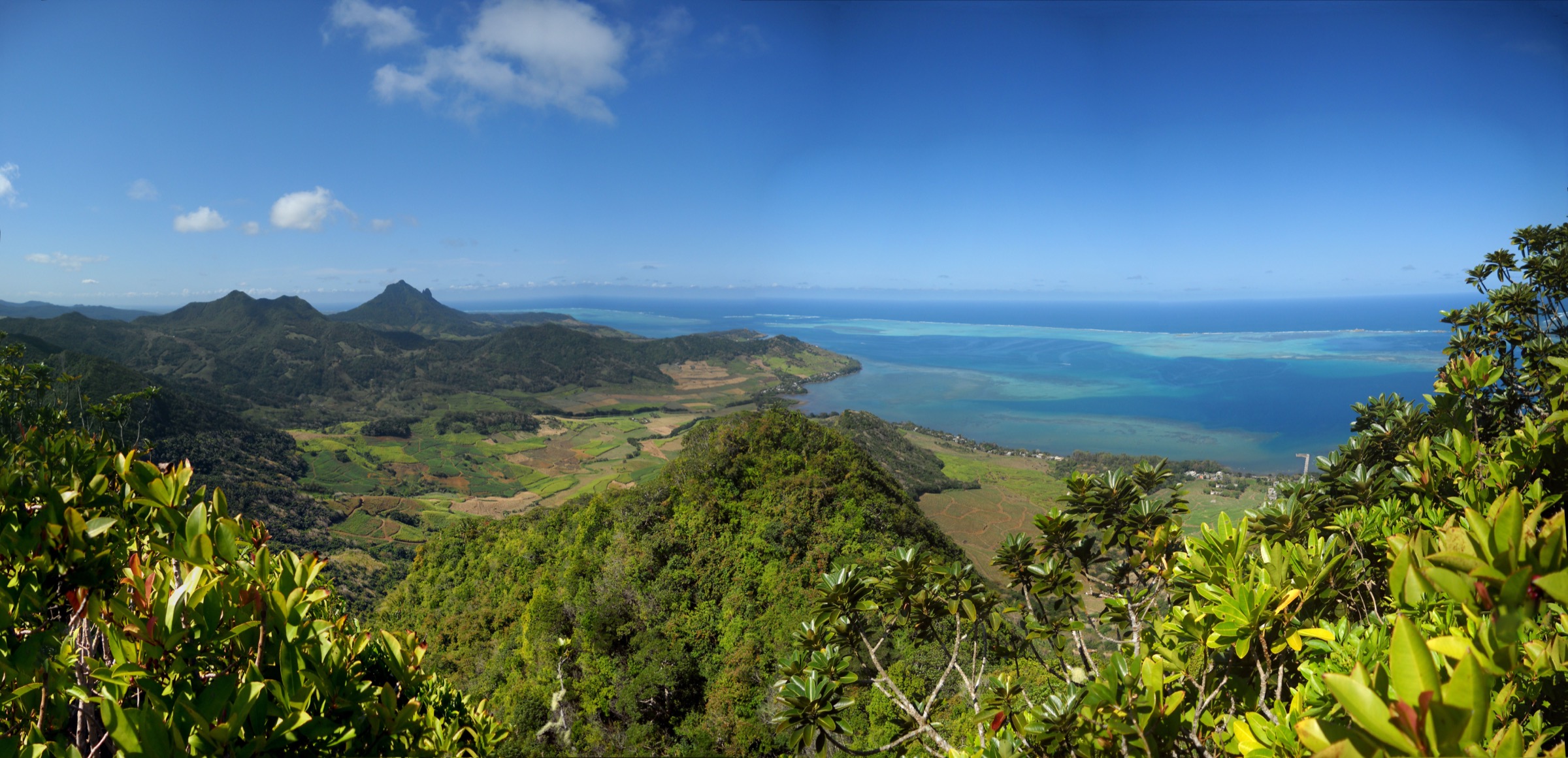
The route leaves the B103 Plaine Champagne Road near the Black River Gorges Viewpoint, drops gently along a wide forest track marked with painted rocks, and then climbs over an undulating ridge through Sideroxylon and other endemic upland forest. After roughly 3 km the track narrows and a short, steep step of perhaps 30 vertical metres, equipped with a fixed rope on a slick dirt slope, leads up to the summit dome. Bench 828 marks the top, with a 360-degree panorama over Le Morne Brabant, Tamarin Bay, the Chamarel highlands, and the inner gorges. Descent is by the same line.
Why it is essential
This is the highest summit in Mauritius and the only true high-mountain objective in the country accessible as a short day walk. The mix of dense upland forest, a brief technical step, and a panoramic island-wide summit view makes it the single most iconic hike on the Rivière Noire range.
Equipment
Standard mountain hiking kit: trail shoes with good grip, weatherproof shell, sun protection, plenty of water, and insect repellent (mosquitoes are persistent in the forest sections). Trekking poles are useful on the descent of the muddy upper step.
Hazards and notes
The short fixed-rope section near the summit is exposed and extremely slippery when wet; the upper route should be avoided after heavy rain. Mud is the dominant hazard year-round. The summit area is exposed to wind and cloud, and visibility can close in within minutes. Stay on the marked track to avoid trampling endemic vegetation in the conservation zone.
GPX / KML links
| Source | URL |
|---|---|
| Komoot: Highest mountain in Mauritius – Piton de la Petite Rivière Noire | komoot.com |
| Hiking Project: Piton de la Petite Rivière Noire | hikingproject.com |
| AllTrails: Macchabee and Colophanne Trail Circular (alternative approach) | alltrails.com |
External links
- Wikipedia — Piton de la Petite Rivière Noire
- Wikipedia — Black River Gorges National Park
- PeakVisor — Piton de la Petite Rivière Noire
2. Macchabée Viewpoint and Mare aux Joncs loop (from Pétrin)
Snapshot
Itinerary
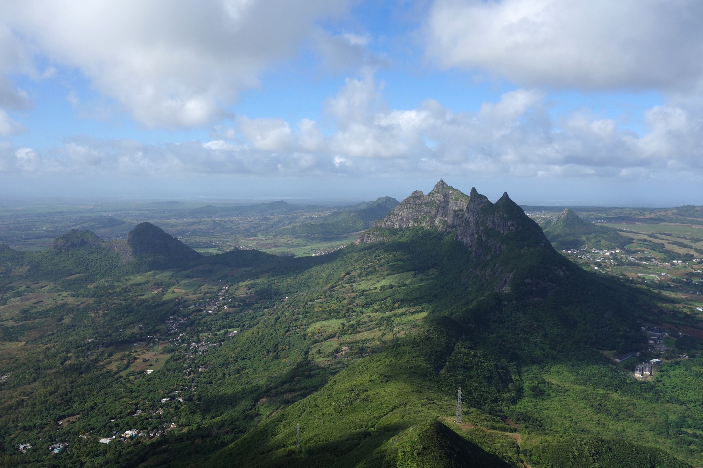
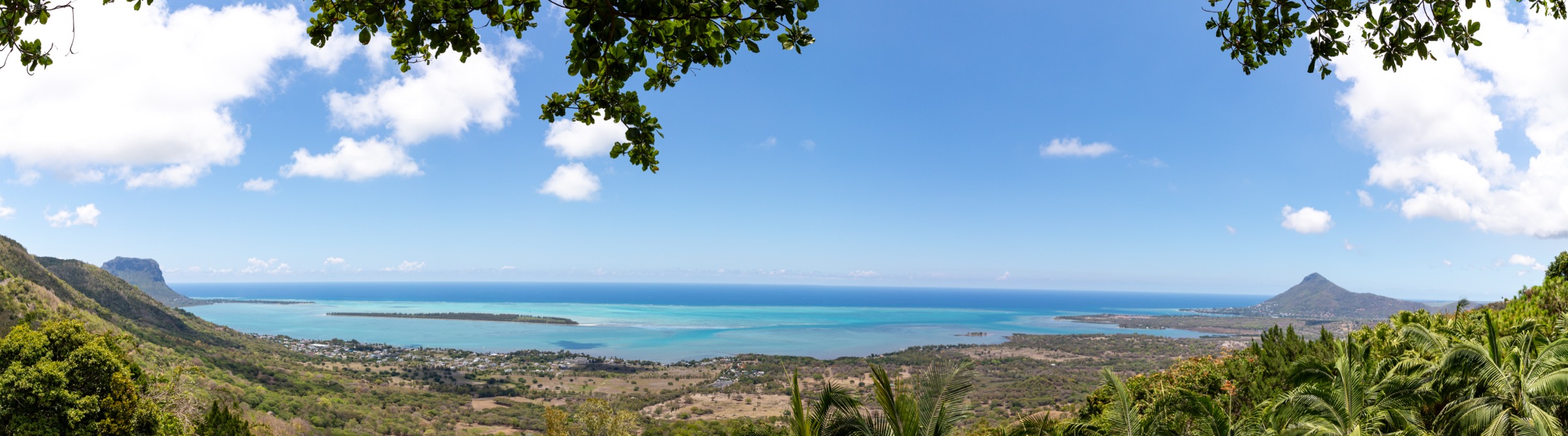
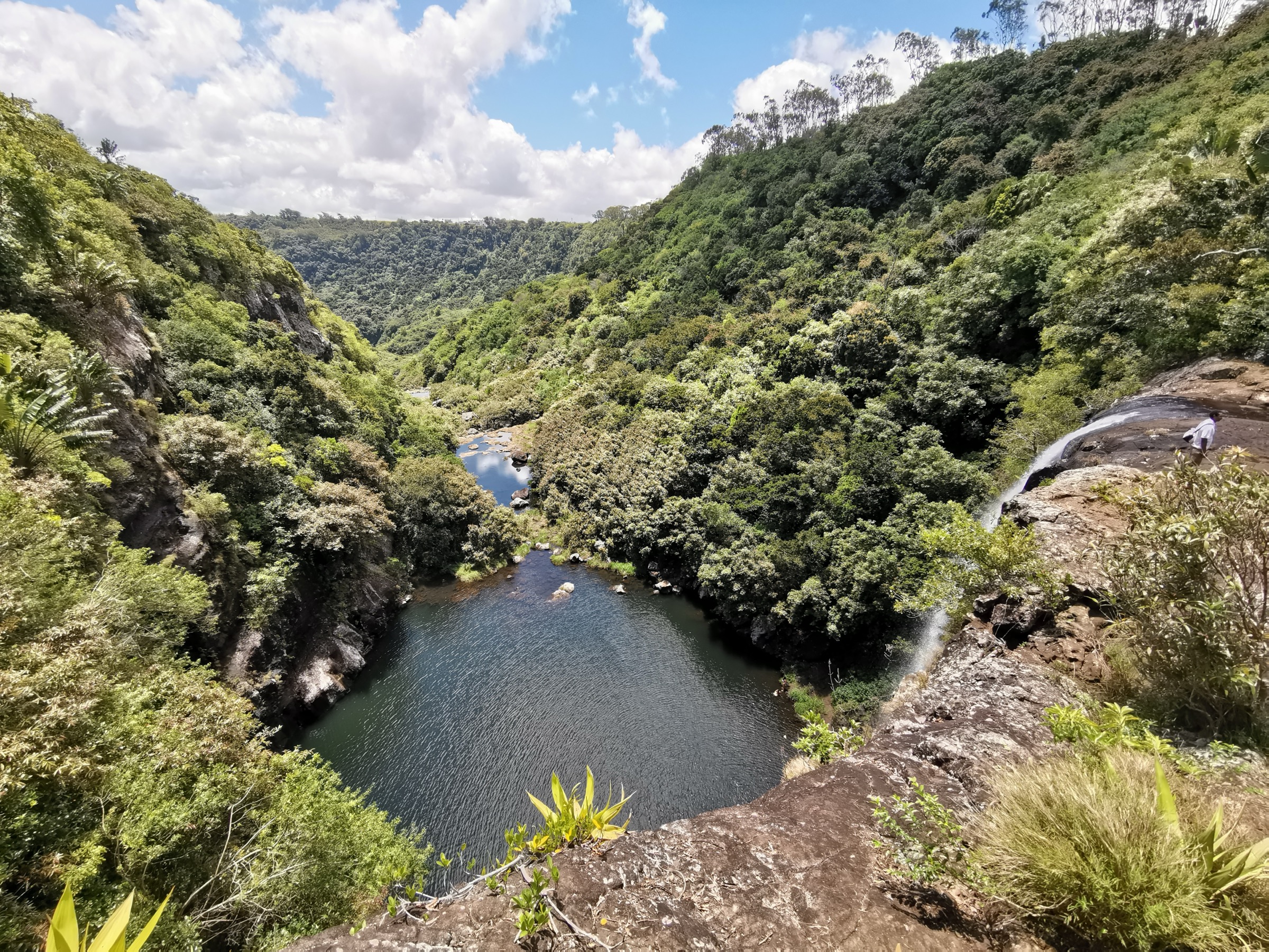
The loop leaves Le Pétrin Information Centre at roughly 665 m, follows the wide Macchabée forest track westwards through native upland forest with informal viewpoints over the gorges, and reaches the main Macchabée Viewpoint at around 570 m after roughly 4.3 km. The viewpoint sits at the edge of a sharp drop and gives the classic Black River Gorges panorama across the deep valley to the Tourelle du Tamarin and the west coast. The loop then descends to the top of the Mare aux Joncs waterfall, follows the ridge back through forest, and returns to Pétrin.
Why it is essential
The Macchabée loop is the classic walking introduction to the Black River Gorges, combining the most photographed viewpoint of the gorges with a substantial waterfall and a representative cross-section of the eastern upland forest. It is wide and well marked, and gives the deepest sense of the interior valleys of any half-day walk in the park.
Equipment
Standard hiking shoes, sun protection, waterproof shell, water, snacks, and insect repellent. Trekking poles are useful on the slick sections near the waterfall descent.
Hazards and notes
The descent to the waterfall and the rim at the Macchabée Viewpoint are unguarded and slippery when wet. Park gates close in the late afternoon; plan timing accordingly. Stay on marked tracks: the surrounding Conservation Management Area is part of an active invasive-species control programme.
GPX / KML links
| Source | URL |
|---|---|
| Komoot: Macchabée Viewpoint – Mare aux Joncs Waterfall loop | komoot.com |
| Komoot: Macchabée Loop Trail | komoot.com |
| AllTrails: Macchabée Viewpoint | alltrails.com |
| Wikiloc: Macchabée and Colophane Trail | wikiloc.com |
External links
- Wikipedia — Black River Gorges National Park
- Ray Plowman — Trails from Le Pétrin Information Centre
- Explore Mauritius — Machabee Ridge Trails
3. Parakeet Trail (Pétrin to Black River)
Snapshot
Itinerary
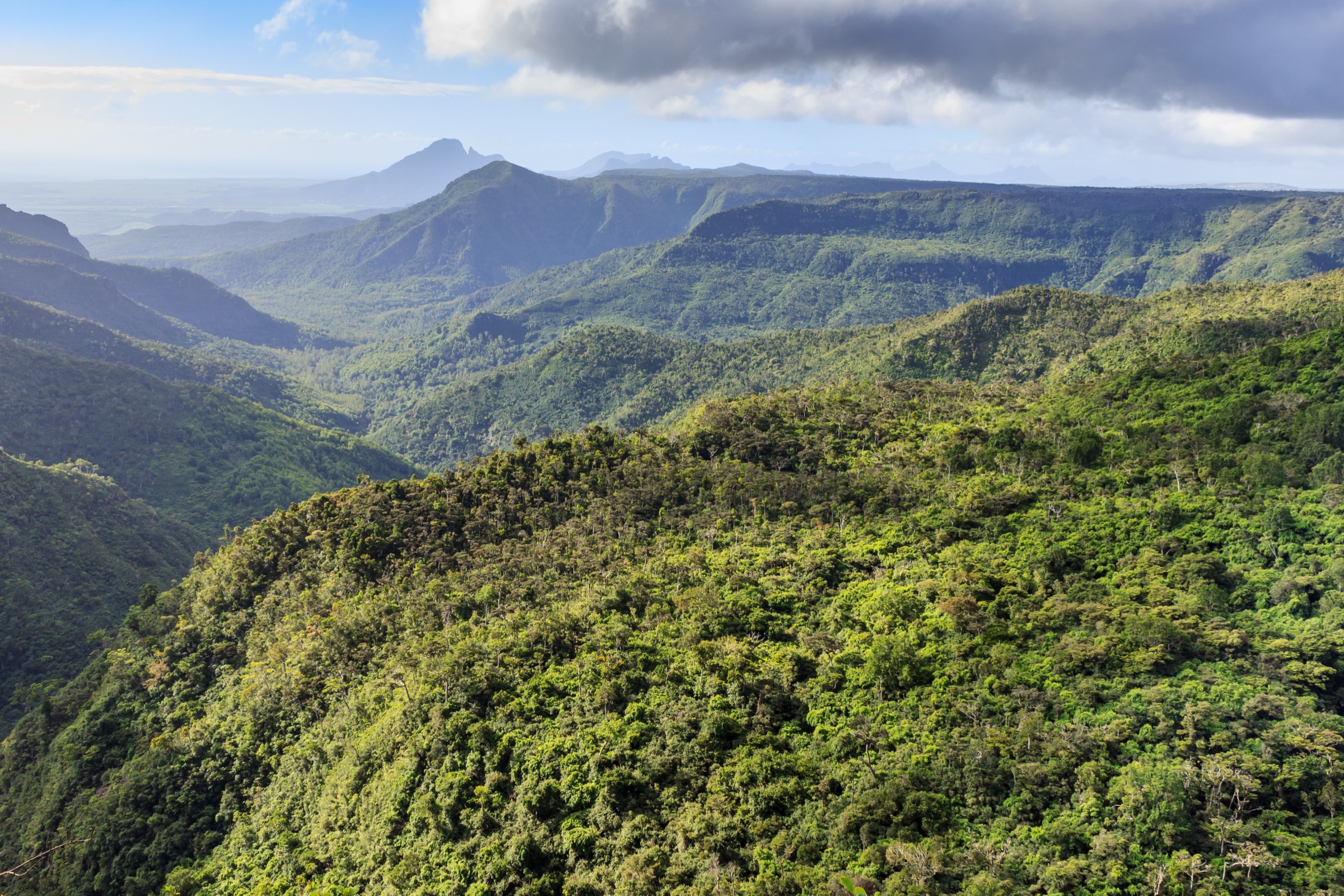
The trail traverses the heart of Black River Gorges National Park, linking the upland Plaine Champagne plateau with the Black River lowlands. From the upper trailhead near Le Pétrin and the Black River Gorges Viewpoint, the path drops steadily through a long shaded corridor of dense rainforest, crosses the Rivière Noire on rocks that are slippery year-round, and climbs out via a final ridge to either the Black River Visitor Centre car park or, in the opposite direction, back up to Plaine Champagne. Most walkers prefer the descending direction from Plaine Champagne, leaving a vehicle or pre-arranged transfer at Black River.
Why it is essential
The Parakeet Trail is the only true day-length traverse of the gorges, descending through a transect of the park’s endemic rainforest and giving the best chance to hear (and occasionally glimpse) the endangered Mauritius kestrel and echo parakeet that give the route its name. It complements the higher-level viewpoint walks by exploring the deep forest interior rather than the rim.
Equipment
Standard hiking kit, sturdy shoes with grip for the river crossing and slick roots, insect repellent, sun protection for the open upper section, and ample water — there is no reliable potable water on the route. Plan vehicle logistics in advance.
Hazards and notes
The river crossing of the Rivière Noire can be dangerous after heavy rain and may be impassable in flood. Wet rocks and mud are persistent on the steeper sections. Mobile coverage is poor in the inner gorges. Begin early to allow the shuttle logistics; gates at both centres close in the late afternoon.
GPX / KML links
| Source | URL |
|---|---|
| Wikiloc: Black River Gorges - Parakeet Trail | wikiloc.com |
| AllTrails: Sentiers de Macchabée, Parakeet, Paille En Queue et Colophanes | alltrails.com |
External links
4. Black River Gorges Viewpoint walk (Plaine Champagne)
Snapshot
Itinerary
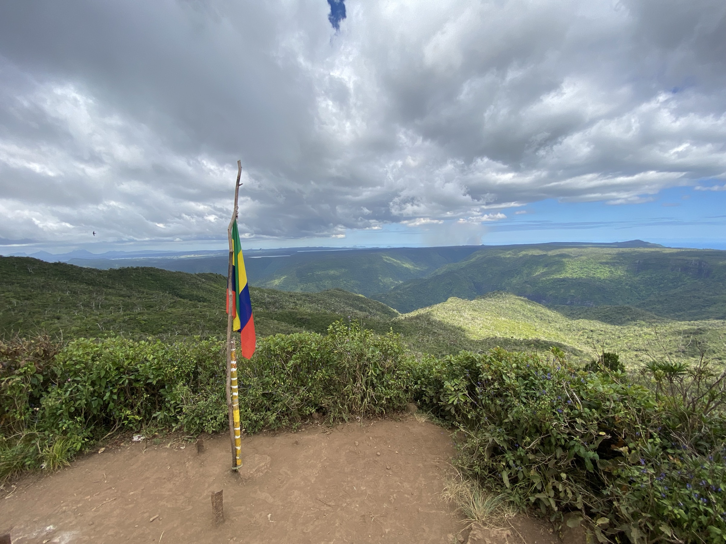
The Black River Gorges Viewpoint sits about 7 km from Chamarel along the B103 Plaine Champagne Road, on the western edge of the upland savanna. A short paved path leads from the car park to a series of railed platforms looking north and west across the heart of the gorges to Piton de la Petite Rivière Noire, Tourelle du Tamarin, and the west coast. The short Trochetia Trail starts at the same car park and gives a quiet 1-km loop through the upland forest as an easy extension; this is also the standard launching point for the Piton de la Petite Rivière Noire and Parakeet routes.
Why it is essential
This is the headline viewpoint of the national park — the single image most often used to represent Mauritius’s mountain interior. It is the only entry in this selection that suits walkers of all abilities and works as a sunrise or sunset stop while travelling between Chamarel and the south coast, making it the natural day-pass-style introduction to the range.
Equipment
No special equipment is needed. Comfortable shoes, sun protection, water, and a light layer for the wind at the rim are sufficient.
Hazards and notes
The viewing platforms are railed but unguarded short paths nearby drop directly into the gorge — supervise children. Cloud frequently fills the gorge from late morning onwards, so plan for an early visit. The viewpoint also serves as a busy car park for several longer trails, so park accordingly.
GPX / KML links
| Source | URL |
|---|---|
| Explore Mauritius: Black River Gorges Viewpoint | exploremauritius.org |
| Explore Mauritius: Trochetia Trail | exploremauritius.org |
External links
- Wikipedia — Black River Gorges National Park
- Wikimedia Commons — Black River Gorges National Park category
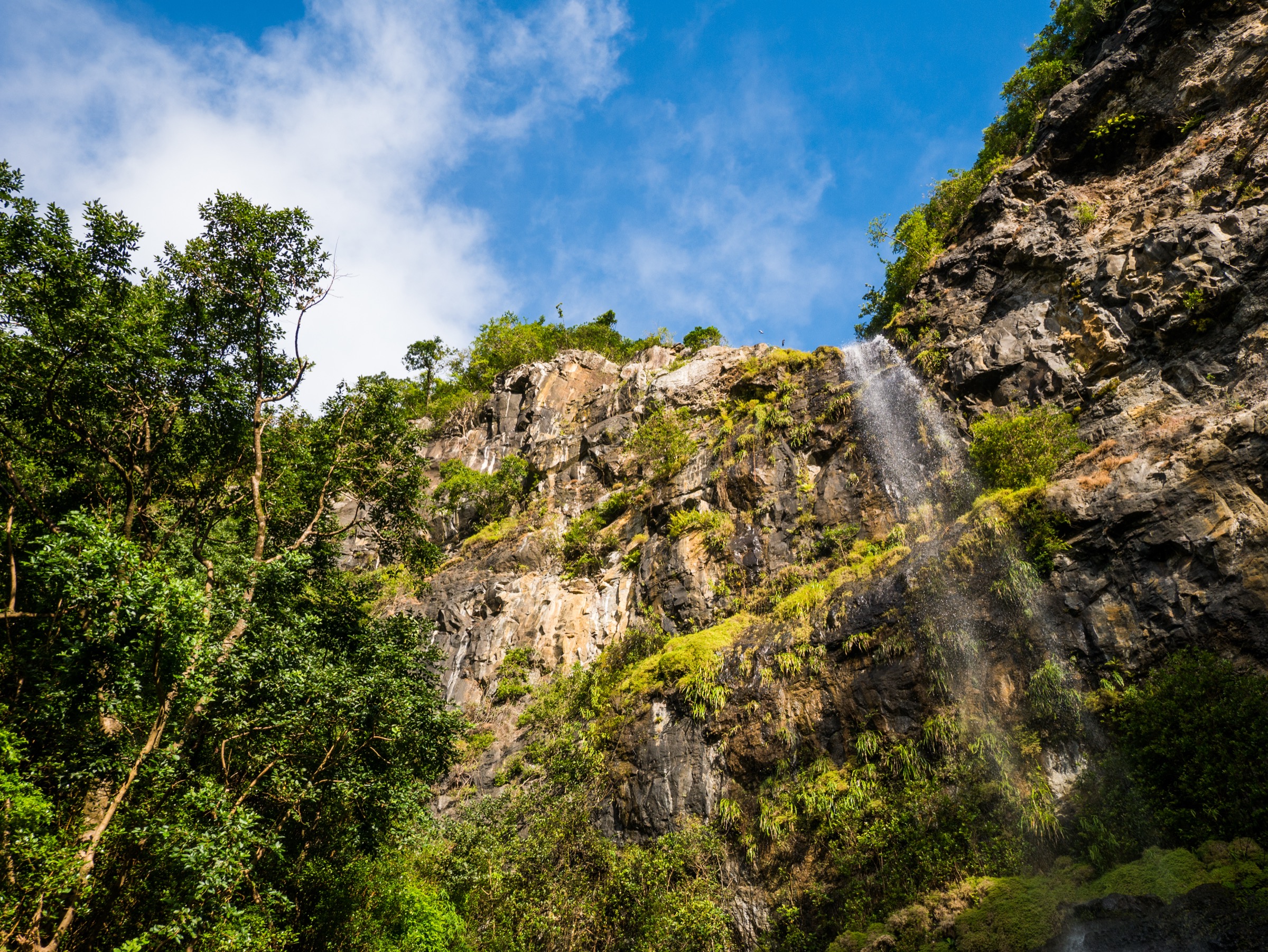
5. Tamarind Falls / Seven Cascades (from Henrietta)
Snapshot
Itinerary
The route starts on the central plateau near Henrietta, follows the Rivière Tamarin down through a wooded valley fringed by guava and other introduced species, and descends past a sequence of pools and viewpoints onto the upper falls. The seven cascades drop progressively along the river towards Tamarin Bay, with a cumulative drop in the order of 250-290 m; the half-day standard reaches four or five of the cascades and returns to Henrietta, while a full-day variant continues lower into the valley and exits down to the Magenta road. Path-finding is informal in places; many sections are unsignposted and worn-in rather than formally constructed.
Why it is essential
This is the regional waterfall day-walk and a logical counterpart to the high gorge hikes, sitting just outside the eastern boundary of the national park on the same central plateau. The combination of seven progressive falls along a single river is unique on Mauritius and produces the most spectacular waterfall sequence accessible on foot within day-hike commitment.
Equipment
Sturdy boots or trail shoes with strong grip, weatherproof shell, sun protection, plenty of water, swimwear and a quick-dry towel if planning to bathe in lower pools, and insect repellent. A local guide is widely recommended for the longer variants; route-finding for first-timers is genuinely difficult.
Hazards and notes
Flash-flood and high-water risk after rain is the dominant hazard — the river can rise rapidly and the descent path is exposed to the gorge. Wet rocks near the falls are extremely slippery. The route is on private and parastatal land in places; some access points require permission or fees. Guided trips from Henrietta or Curepipe are common and recommended for the full Seven Cascades variant.
GPX / KML links
| Source | URL |
|---|---|
| AllTrails: Seven Cascades Short Loop | alltrails.com |
| Komoot: Tamarind Falls highlight | komoot.com |
External links
External links
| Source | URL |
|---|---|
| Wikipedia — Black River Gorges National Park | en.wikipedia.org |
| Wikipedia — Piton de la Petite Rivière Noire | en.wikipedia.org |
| Wikipedia — Tamarind Falls | en.wikipedia.org |
| Wikipedia — Geography of Mauritius | en.wikipedia.org |
| PeakVisor — Piton de la Petite Rivière Noire | peakvisor.com |
| Komoot — Piton de la Petite Rivière Noire | komoot.com |
| Komoot — Macchabée Viewpoint and Mare aux Joncs Waterfall loop | komoot.com |
| Komoot — Macchabée Loop Trail | komoot.com |
| AllTrails — Macchabée Viewpoint | alltrails.com |
| AllTrails — Macchabée and Colophanne Trail Circular | alltrails.com |
| AllTrails — Seven Cascades Short Loop | alltrails.com |
| AllTrails — Best trails in Black River Gorges National Park | alltrails.com |
| Hiking Project — Piton de la Petite Rivière Noire | hikingproject.com |
| Wikiloc — Black River Gorges Parakeet Trail | wikiloc.com |
| Wikiloc — Macchabée and Colophane Trail | wikiloc.com |
| Explore Mauritius — Parakeet Trail | exploremauritius.org |
| Explore Mauritius — Black River Gorges Viewpoint | exploremauritius.org |
| Explore Mauritius — Trochetia Trail | exploremauritius.org |
| Explore Mauritius — Machabee Ridge Trails | exploremauritius.org |
| Ray Plowman — Trails from Le Pétrin Information Centre | rayplowman.co.uk |
| Wikimedia Commons — Black River Gorges National Park category | commons.wikimedia.org |
| Wikimedia Commons — Piton de la Petite Rivière Noire category | commons.wikimedia.org |
| Wikimedia Commons — Tamarind Falls category | commons.wikimedia.org |