Regional overview
The Bambous Mountains (Montagnes Bambous, also written as the Bambou Range) form the volcanic spine of southeastern Mauritius, running roughly north from Mahébourg up the coast through Bambous Virieux, Bois des Amourettes, and Anse Jonchée to the heights inland of Quatre Soeurs. The range is one of the five recognised mountain chains of Mauritius and is closely entangled with the neighbouring Grand Port Range; sources differ on where one ends and the other begins, and several individual peaks (notably Lion Mountain) are attributed to both. For the purpose of this catalogue the Bambous Mountains are treated as the broader southeastern coastal massif that includes the Grand Port range hinterland, with Mont Bambou (about 626-631 m) as the highest summit and Lion Mountain (480-490 m) as the most recognisable.
Trailheads cluster around Vieux Grand Port and the Virieux Grand Port police station for Lion Mountain, Belle Rive near the Sir Seewoosagur Ramgoolam Memorial Park for Mont Bambou, the Vallée de Ferney visitor centre on the B28 road north of Mahébourg for the forest routes, and Bois des Amourettes for the coastal walk towards Devil’s Point. Public transport along the coast road between Mahébourg, Bambous Virieux, and Bois des Amourettes is reasonable; the inland approach to Mont Bambou is more practical by private vehicle. Mahébourg itself is well connected by intercity bus and is around fifteen minutes from Sir Seewoosagur Ramgoolam International Airport.
The best walking season is the cool, drier southern-hemisphere winter from roughly May to October. Cyclone season runs November to April, with the heaviest tropical rain and humidity in January and February; trails on Lion Mountain and Mont Bambou become genuinely dangerous when wet, with clay surfaces, exposed rocky scrambles, and slippery roots. Trails outside Vallée de Ferney are largely unmarked and overgrown, navigation is non-trivial, and several local operators run guided ascents that are worth considering. The Vallée de Ferney conservation reserve is privately managed and requires advance booking and an entrance fee.
Selection rationale
The five entries balance the regional icon (Lion Mountain), the highest and most demanding summit (Mont Bambou), two contrasting walks inside the Vallée de Ferney reserve that showcase the indigenous forest and the eastern ridgeline, and the historic coastal walk from Bois des Amourettes to Pointe du Diable that ties together the 1810 Battle of Grand Port sites and the views back to the range. The routes spread across four trailheads and four character types: iconic short summit, strenuous high summit, forest-reserve loops, and coastal-historic walk.
Summary table
| # | Hike | Country | Route type | Distance | Gain | Max elevation | Difficulty |
|---|---|---|---|---|---|---|---|
| 1 | Lion Mountain from Vieux Grand Port | Mauritius | Loop or out-and-back | 7-8 km | 480-580 m | 480-490 m | Moderate-Hard |
| 2 | Mont Bambou (Montagne Bambous) | Mauritius | Out-and-back | 8-9 km | 500-720 m | 626-631 m | Hard |
| 3 | Vallée de Ferney — Route 03 (medium) | Mauritius | Loop | 13 km | 530 m | ~400 m | Moderate |
| 4 | Vallée de Ferney — Route 04 (long) | Mauritius | Loop | 18 km | 970 m | ~500 m | Hard |
| 5 | Bois des Amourettes to Pointe du Diable | Mauritius | Point-to-point or out-and-back | 10-14 km | Minor | 20 m | Easy |
1. Lion Mountain from Vieux Grand Port
Snapshot
Itinerary
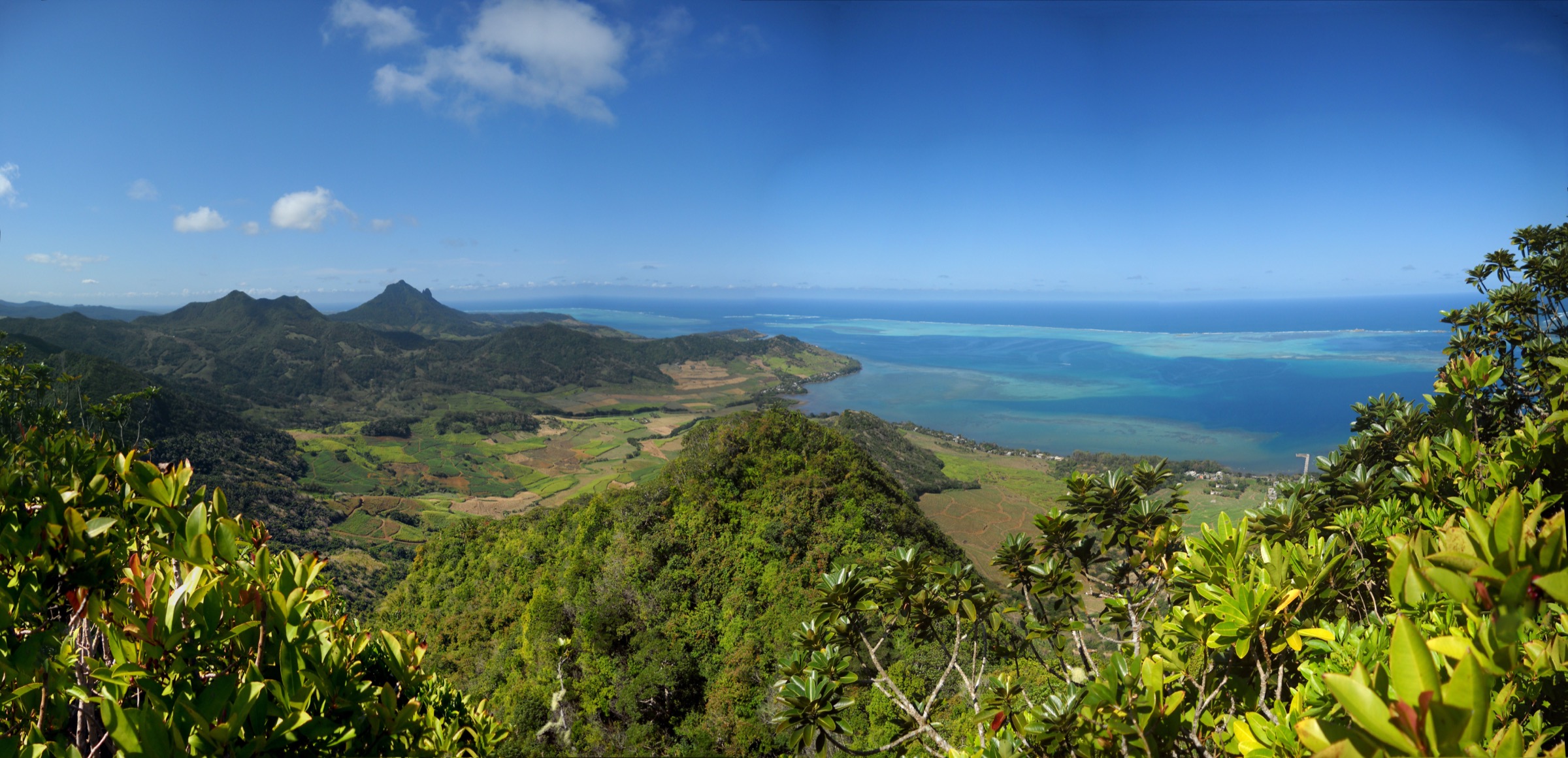
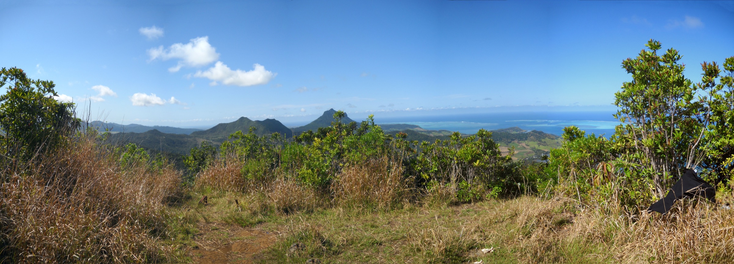
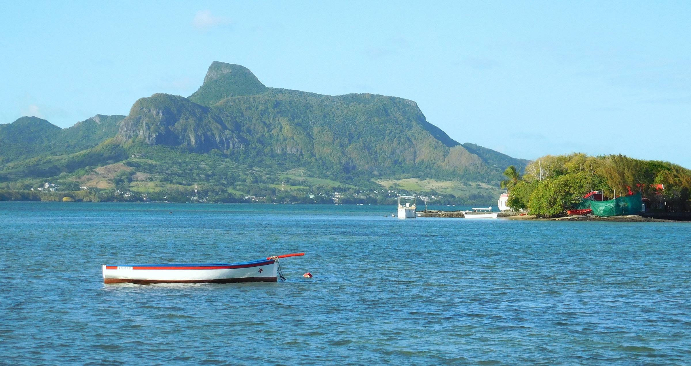
The walk begins at the bus stop near the Virieux Grand Port police station, crosses sugarcane on a level track, and turns inland onto an unmarked but well-trodden path that climbs through shaded forest along the western flank. The trail steepens onto the ridge known locally as the lion’s spine, with several short rocky steps requiring hands. A scramble through the “lion’s neck” leads onto the summit dome at the “lion’s forehead”, which offers a 360-degree view over the lagoon of Grand Port, the islets off Mahébourg, the Pointe du Diable headland to the north, and the broader Bambous Mountains inland. The standard return descends the ascent line; an alternative line down the southeastern face (towards the “front paw”) closes the loop back to the coast road.
Why it is essential
Lion Mountain is the defining landmark of southeastern Mauritius and the most photographed summit in the Bambous range, with a strong cultural identity (the sleeping-lion silhouette), accessibility from Mahébourg, and the historical setting of the 1810 Battle of Grand Port directly below the summit.
Equipment
Mountain hiking equipment: sturdy boots with good grip, sun protection, two to three litres of water, snacks, and a waterproof shell. Trekking poles are of limited use on the upper rocky sections. A printed map or GPS track is strongly recommended; the trail is unmarked and has multiple branches.
Hazards and notes
The clay surfaces become extremely slippery after rain and the upper scramble is exposed; descents are the main hazard. A local guide is widely recommended for first-time visitors. Avoid private hunting areas to the north of the ridge. Mosquitoes can be persistent in the forest; carry repellent.
GPX / KML links
| Source | URL |
|---|---|
| Outdooractive: Lion Mountain - Grand Port - Mauritius | outdooractive.com |
| AllTrails: Lion’s Mountain, Grand Port | alltrails.com |
| Explore Mauritius: Lion Mountain (GPX download referenced) | exploremauritius.org |
External links
- Wikipedia — Lion Mountain, Mauritius
- Explore Mauritius — Lion Mountain
- Outdooractive — Lion Mountain, Grand Port
- Wikimedia Commons — Lion Mountain category
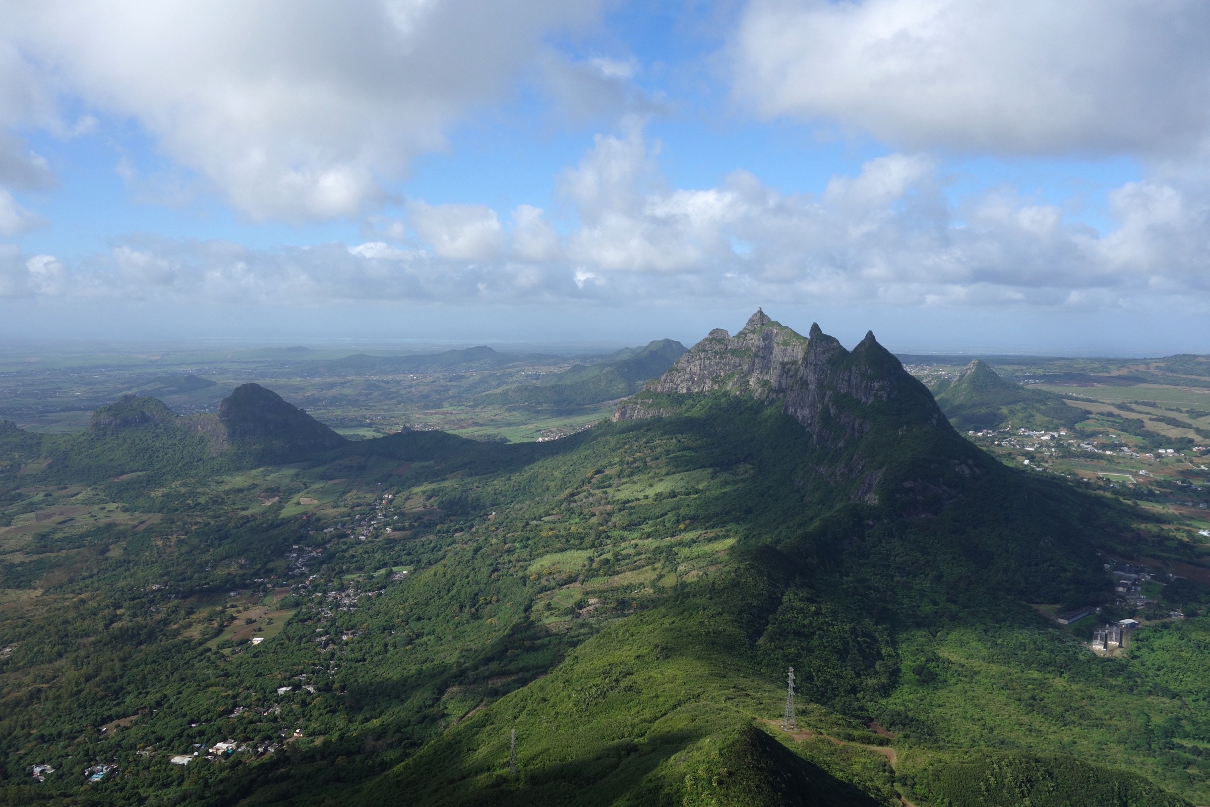
2. Mont Bambou (Montagne Bambous)
Snapshot
Itinerary
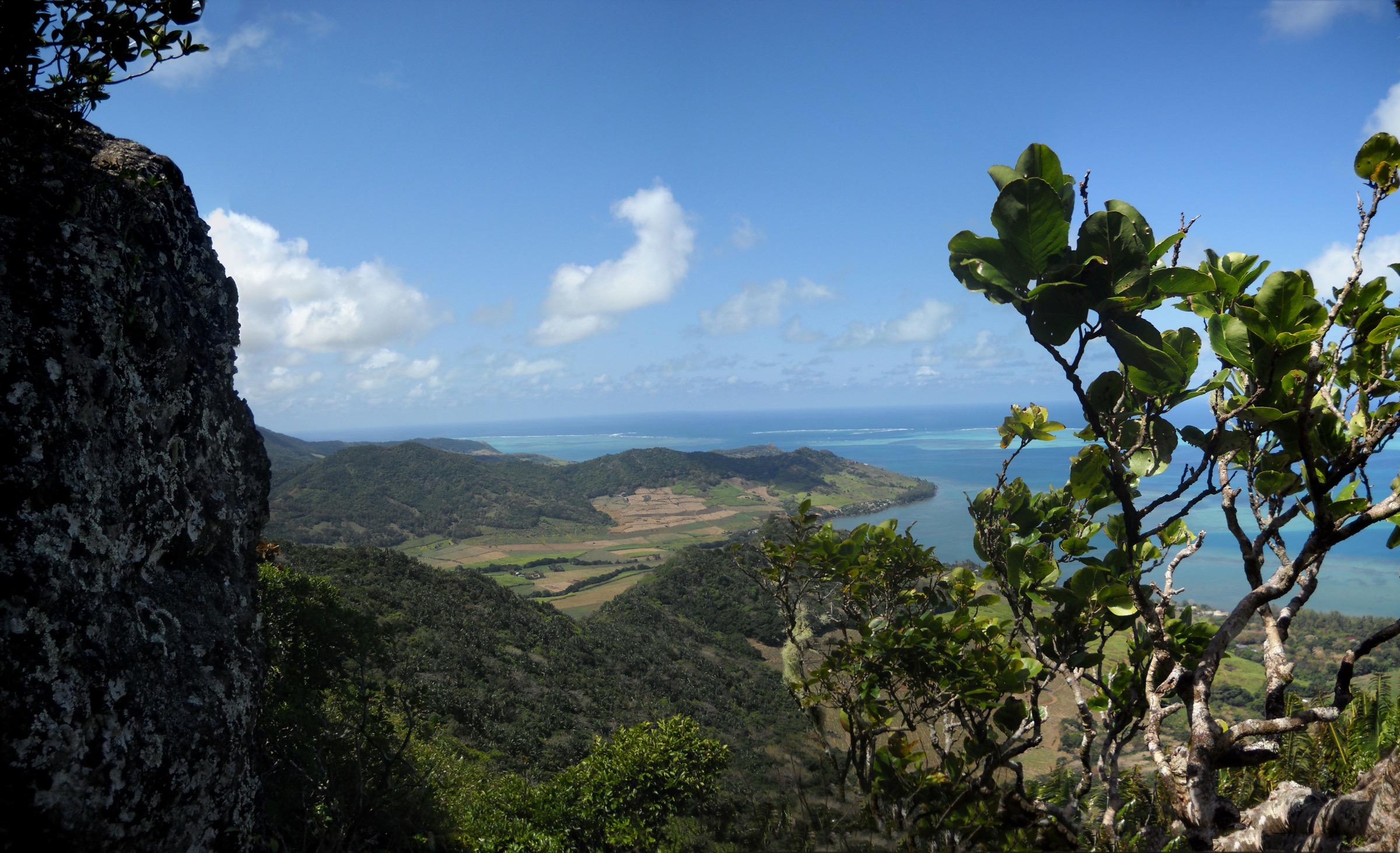
The route leaves the Belle Rive parking area outside the Sir Seewoosagur Ramgoolam Memorial Park, drops over a small stream into thick undergrowth, and follows tracks through a working sugar estate up to the forest edge. The trail rises gradually south through palm forest onto the long northern ridge of Mont Bambou, then climbs steeply along the ridge to the rocky summit. The path disappears in places; the rule of thumb is to stay on the ridge crest and use guava-tree roots as natural handholds. A short, exposed rock step just below the summit has a drop on either side and is the technical crux. The summit gives a complete 360-degree panorama across the southeast lagoons, the Vallée de Ferney, the Grand Port plain, and inland to the Black River and Moka ranges.
Why it is essential
Mont Bambou is the highest peak of the Bambous Mountains and one of the most committing day-hikes in Mauritius; the summit panorama is widely cited as among the finest on the island, and the climb is the natural counterweight to the shorter, more popular Lion Mountain in the same range.
Equipment
Mountain hiking equipment with an emphasis on grippy footwear, gloves for the scramble, long sleeves and trousers to deal with thick undergrowth and palm leaves, two to three litres of water, sun protection, and a phone or GPS loaded with the route in advance. Mosquito repellent is essential in the lower forest.
Hazards and notes
The trail is unmarked, regularly overgrown, and difficult to follow; previous parties have lost the route. Wet rock makes the upper scramble seriously dangerous and the ridge has fall-exposure on both sides. Avoid after any prolonged rain. Cell coverage on the upper sections is unreliable. A local guide is sensible for first-time attempts.
GPX / KML links
| Source | URL |
|---|---|
| AllTrails: Mount Bambous, Flacq | alltrails.com |
| Wikiloc: Montagne Bambous 10-AUG-12 | wikiloc.com |
| Explore Mauritius: Montagne Bambous (GPX download referenced) | exploremauritius.org |
| Fitsy: Bambous mountain route | fitsy.com |
External links
3. Vallée de Ferney — Route 03 (medium loop)
Snapshot
Itinerary
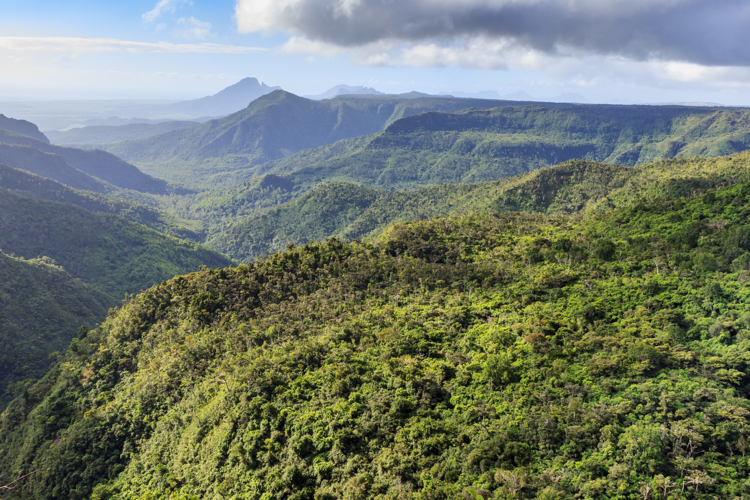
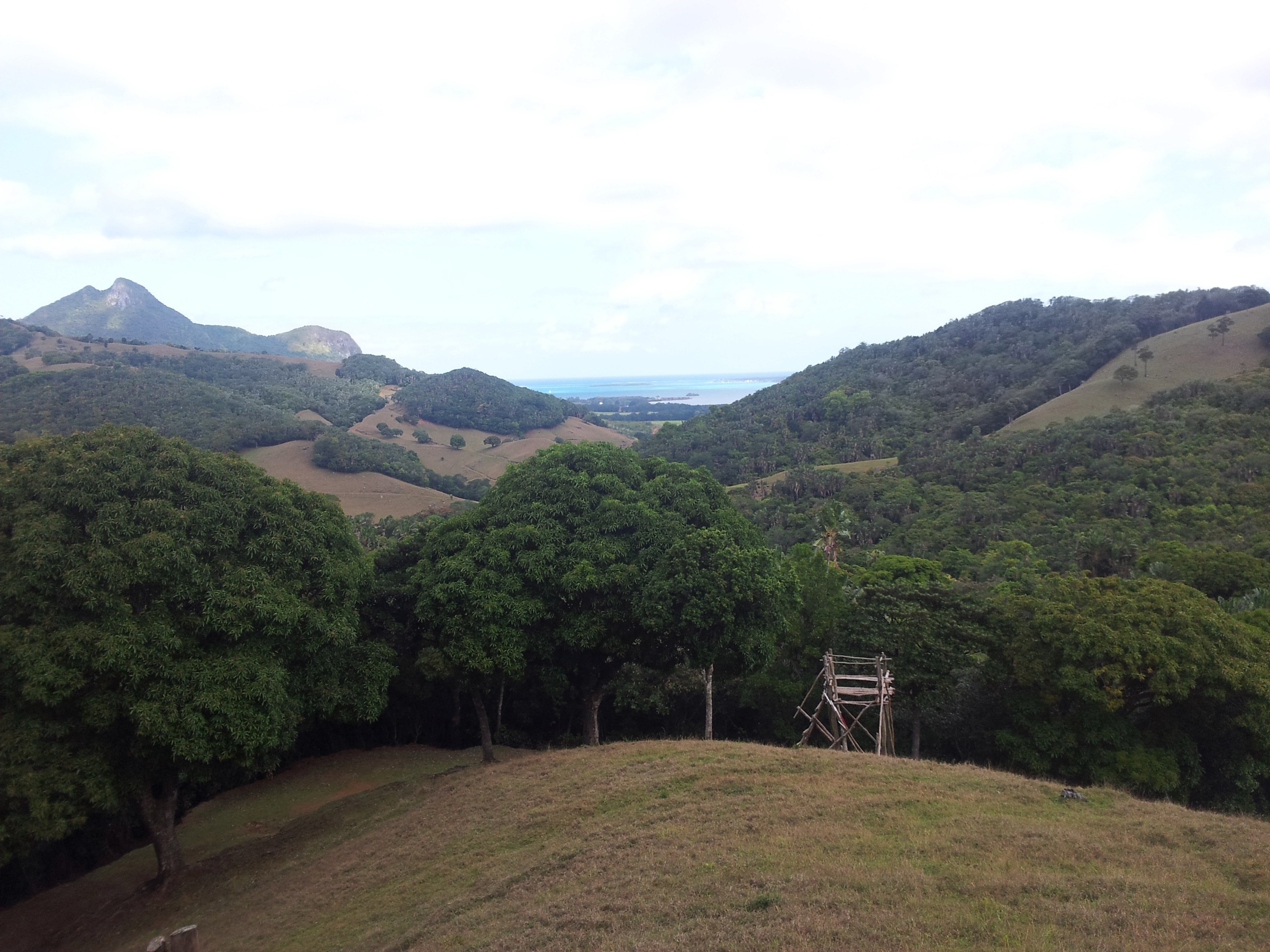
Route 03 is the middle option of the four official Vallée de Ferney trails. It departs the visitor centre at 11:30 in the morning according to the reserve’s published schedule, crosses the lower restored ebony and takamaka forest, and climbs onto a higher ridge inside the 200-hectare reserve before looping back through the open plains. The trail passes the kestrel feeding area and the tortoise enclosure, with viewpoints down to Ile aux Aigrettes, the Grand Port lagoon, and Mahébourg. The route is on open track throughout and is managed by the La Vallée de Ferney Conservation Trust, established at the end of 2006 in partnership with the Mauritian Wildlife Foundation.
Why it is essential
The Vallée de Ferney protects one of the last surviving pockets of native lowland forest in Mauritius (less than two per cent of indigenous ecosystems remain on the island) and is the best practical day-walk for seeing Mauritius kestrels, echo parakeets, pink pigeons, Mauritian flying foxes, and endemic Pandanus, Eugenia, and ebony species in their natural habitat. It is the conservation-significance counterpart to the open summits elsewhere in the selection.
Equipment
Standard hiking equipment: sturdy walking shoes, sun protection, hat, jacket, and at least 1.5 litres of water. The reserve recommends sunblock specifically. No technical equipment is required.
Hazards and notes
The reserve is privately managed; advance booking is recommended, especially in the high season from June to September. Activity hours are 8:30 to 14:00 and trails start at fixed times. Entry fee applies (around Rs 500 for adult tourists at time of writing). Sun exposure on the upper plains is significant. Do not leave marked tracks; conservation areas are off-limits.
GPX / KML links
| Source | URL |
|---|---|
| La Vallée de Ferney — Hiking & Biking Trails | ferney.mu |
External links
- Wikipedia — Vallée de Ferney
- La Vallée de Ferney — Hiking trails
- Mauritian Wildlife Foundation
- Wikimedia Commons — Vallée de Ferney category
4. Vallée de Ferney — Route 04 (long ridge traverse)
Photo status: No licence-compatible image found in this pass for the long Route 04 specifically; see the Route 03 image above for the same reserve.
Snapshot
Itinerary
Route 04 is the longest and most strenuous of the four Vallée de Ferney trails. The reserve publishes a 10:30 start time and treats the route as a “technical course”; it climbs from the visitor centre onto the higher Bambous ridgelines inside the reserve’s 200 hectares, traverses sections of open ridge with long views back over the lagoon and across to Mont Bambou, and loops back through the indigenous-forest restoration plots. The full circuit is the most committing day-hike inside the reserve and the closest practical alternative to climbing Mont Bambou by an unmanaged route.
Why it is essential
For walkers who want a long ridge-style traverse with reserve-grade biodiversity, Route 04 combines roughly the distance and elevation profile of a serious mountain day with the safety net of a managed, regularly cleared trail and a guided ascent option. It is the natural ridge-walk entry for this selection.
Equipment
Mountain hiking equipment: sturdy boots, two to three litres of water, sun protection, hat, jacket, and food for a long day. The reserve recommends sunblock, water, appropriate footwear, hat and jacket as essentials.
Hazards and notes
Advance booking is essential; the route departs from the visitor centre on a fixed schedule. Sun exposure on the upper ridges is significant. The track is open and managed but still tiring; pace accordingly. Avoid in the heaviest summer rain.
GPX / KML links
| Source | URL |
|---|---|
| La Vallée de Ferney — Hiking & Biking Trails | ferney.mu |
External links
5. Bois des Amourettes to Pointe du Diable
Snapshot
Itinerary
The walk follows the B28 coastal road north from the village of Bois des Amourettes, set between the Lion Mountain massif and the Grand Port lagoon. The route passes the historic 190-metre Dutch-era jetty at Bois des Amourettes with views out to Ile aux Fouquets (and its 1865 lighthouse), Ile de la Passe (with the ruined fortifications used in the 1810 Battle of Grand Port), and Ile Vacoas. From there the walk continues through the small settlement of Providence, the agricultural plain around Bambous Virieux, and on past Anse Jonchée to the Pointe du Diable headland, where the eighteenth-century French cannon emplacements still stand and where ships’ compasses were historically said to deviate (the origin of the “Devil’s Point” name). The lookout gives a wide view back south along the Bambous coast and inland to the range.
Why it is essential
This is the cultural-historic route in the selection. It threads together the most concentrated sequence of Battle of Grand Port heritage sites in Mauritius (Frederik Hendrik Museum, Île de la Passe, Pointe du Diable battery) and gives a sustained low-elevation view of the entire Bambous coast that complements the high-summit walks elsewhere in this guide.
Equipment
Light hiking shoes or trainers, sun protection, hat, two litres of water, snacks, and a small daypack. Some shade is available in coastal village sections but the open road is exposed.
Hazards and notes
Most of the route is on the B28 coast road; traffic is light by Mauritius standards but pedestrians should walk facing oncoming traffic. The Pointe du Diable viewpoint itself has unfenced cliff edges and is exposed to strong onshore winds. Bring more water than expected in summer. There is no continuous off-road coastal trail; this is essentially a long coastal road walk with viewpoint stops.
GPX / KML links
| Source | URL |
|---|---|
| OpenStreetMap — B28 coast road segment, Grand Port | openstreetmap.org |
External links
- Wikipedia — Vieux Grand Port
- Wikipedia — Battle of Grand Port
- The Love of Photos — Hiking from Ferney to Devil’s Point
- Rough Guides — East Coast Mauritius
External links
| Source | URL |
|---|---|
| Wikipedia — Lion Mountain, Mauritius | en.wikipedia.org |
| Wikipedia — Vallée de Ferney | en.wikipedia.org |
| Wikipedia — Vieux Grand Port | en.wikipedia.org |
| Wikipedia — Battle of Grand Port | en.wikipedia.org |
| PeakVisor — Mount Bambou | peakvisor.com |
| PeakVisor — Grand Port Mountains | peakvisor.com |
| Explore Mauritius — Lion Mountain | exploremauritius.org |
| Explore Mauritius — Montagne Bambous | exploremauritius.org |
| Outdooractive — Lion Mountain, Grand Port | outdooractive.com |
| AllTrails — Lion’s Mountain, Grand Port | alltrails.com |
| AllTrails — Mount Bambous, Flacq | alltrails.com |
| Wikiloc — Montagne Bambous 10-AUG-12 | wikiloc.com |
| Fitsy — Bambous mountain | fitsy.com |
| La Vallée de Ferney — Hiking trails | ferney.mu |
| Mauritian Wildlife Foundation | mauritian-wildlife.org |
| Heritage Resorts — Mountains of Mauritius | heritageresorts.mu |
| Rough Guides — East Coast Mauritius | roughguides.com |
| Wikimedia Commons — Lion Mountain, Mauritius category | commons.wikimedia.org |
| Wikimedia Commons — Vallée de Ferney category | commons.wikimedia.org |
| Wikimedia Commons — Bambous, Mauritius category | commons.wikimedia.org |