Regional overview
The Kazakh Tian Shan is centred on the north-facing ranges above Almaty and the high lake country of the Kungey Alatau near Saty and Kolsai. The walking character is unusually varied for a compact region: city-edge forest gorges, old pipeline and mountain-road approaches, alpine meadows, moraine lakes, waterfalls, high observatory roads, and glacier-view routes below 4,000 m peaks.
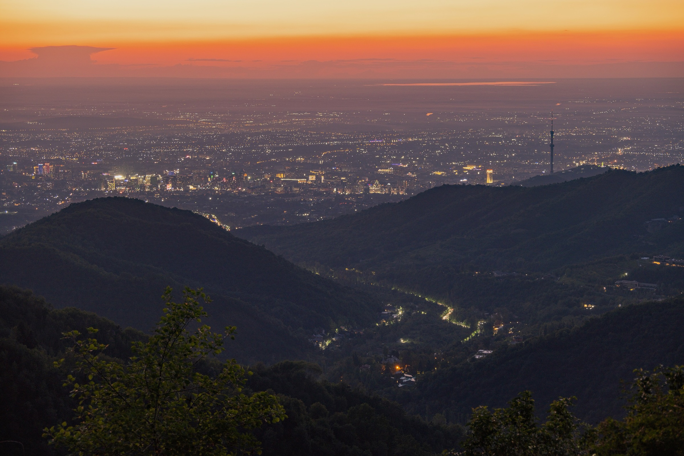
The main hiking centres are Almaty, Medeu, Shymbulak, Big Almaty Gorge, Turgen Gorge, and Saty/Kolsai Lakes. Access is generally easiest from Almaty, but trailheads range from public-bus accessible city-edge starts to remote national-park roadheads requiring private transport or an arranged driver.
The normal walking season is late spring to autumn. Lower gorge routes can be possible outside summer, but snow, ice, avalanche exposure, mud, river crossings, and closed access roads can make upper routes more serious. Big Almaty Lake and parts of the upper Big Almaty Gorge are close to the Kyrgyz border and water-supply infrastructure; identity documents, national-park fees, border checks, and local access restrictions must be treated as current-condition issues.
Selection rationale
The five hikes below cover the key day-hiking identities of the Kazakh Tian Shan: the iconic Big Almaty Lake approach, the classic Kok-Zhailau city balcony, the Kolsai lake-to-lake forest trail, the major Turgen Gorge waterfall walk, and the high glacier-view track from Tuyuksu Alpine Camp to T1. Official Visit Almaty pages verify several routes and access patterns; route databases and guide sources provide secondary statistics where official GPX-grade data is incomplete.
Summary table
| # | Hike | Country | Route type | Distance | Gain | Max elevation | Difficulty |
|---|---|---|---|---|---|---|---|
| 1 | Big Almaty Lake from the roadblock / pipeline | Kazakhstan | Loop / out-and-back variants | 10.6-16 km depending source/variant | 713-1,000 m depending source/variant | 2,657 m on AllTrails source-map; lake about 2,506-2,510 m | Hard |
| 2 | Kok-Zhailau Plateau from Medeu / Prosveshchenets | Kazakhstan | Out-and-back or traverse | 8 km round trip from AlmatyHiking; traverse variants longer | 671 m | Approx. 1,740 m plateau; extensions higher | Easy-moderate |
| 3 | Kolsai Lake 1 to Middle Kolsai Lake | Kazakhstan | Out-and-back | 14.3-16 km depending source/shore variant | 450-790 m depending source/variant | 2,259 m on AllTrails; Middle Kolsai about 2,250 m | Moderate-hard |
| 4 | Turgen Gorge to Kairak Waterfall | Kazakhstan | Out-and-back / source-map point-to-point variant | 15-16 km return from Batan; AllTrails source-map reports 7.6 km point-to-point | Approx. 590 m on AllTrails source-map | Approx. 2,130 m at waterfall | Moderate-hard |
| 5 | Tuyuksu Alpine Camp to T1 / Mynzhylky Glacier View | Kazakhstan | Out-and-back | 15 km | 1,060 m | 3,650 m | Moderate-hard |
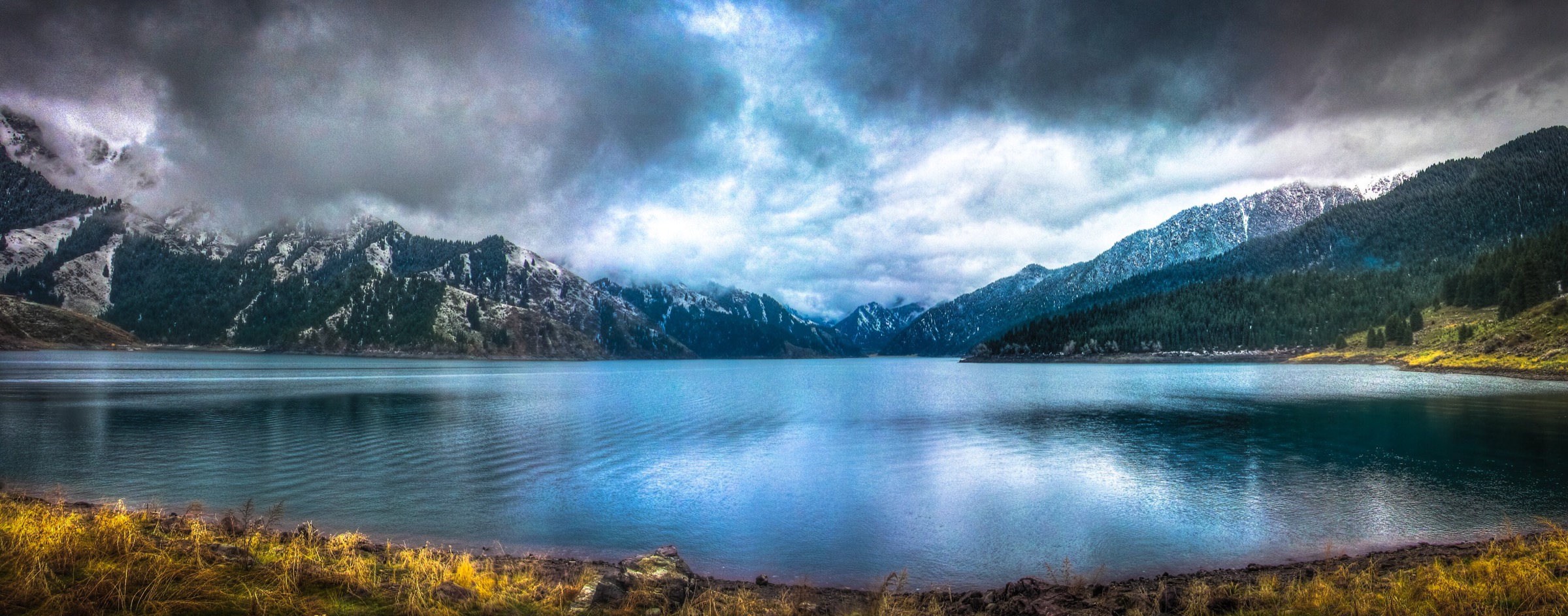
1. Big Almaty Lake from the roadblock / pipeline
Snapshot
Itinerary
The route climbs the Big Almaty Gorge towards the turquoise reservoir-lake that supplies part of Almaty’s drinking water. Current access normally starts below the lake because direct road access has been restricted. The walking line follows a combination of paved road, pipeline track, and local shortcuts where permitted, passing the Alpine Rose area and Moon Glade before reaching the lake shore viewpoints.
The route should be treated as a lake-view approach rather than a free lakeshore wander. Big Almaty Lake is a water-protection zone, and the surrounding upper valley is close to the state border. Some variants return by the road, while others use the pipeline route; exact access must be checked locally on the day.
Why it is essential
Big Almaty Lake is one of the defining images of the northern Tian Shan above Almaty: a high turquoise lake surrounded by steep alpine walls, with the Big Almaty Peak / Turist skyline above it. The walk is also representative of the region’s managed mountain access, where water infrastructure, border controls, and national-park rules shape the day-hiking experience.
Equipment
- Sturdy footwear
- Weatherproof and warm layers
- Sun protection
- Water and food
- Map/GPS and power bank
- Trekking poles
- Valid identity documents for possible border or police checks
Hazards and notes
- The upper gorge can be cold and windy even when Almaty is hot.
- Early-season snow, icy pipeline sections, altitude effects, rockfall, and fast-changing weather are realistic concerns.
- Do not enter restricted water-supply areas or continue towards the border without the appropriate permission.
- The route should be started early because the full walking approach is long.
GPX / KML links
| Source | URL | Format / access | Reuse status |
|---|---|---|---|
| AllTrails: Big Almaty Lake Loop | alltrails.com | Source map / app route | AllTrails terms apply; GPX export and reuse terms not verified |
| OpenStreetMap search: Big Almaty Lake | openstreetmap.org | Map / search | OSM data is ODbL |
| AlmatyHiking: Big Almaty Lake | almatyhiking.kz | Guide route page | Site terms apply; no route-file licence found |
External links
2. Kok-Zhailau Plateau from Medeu / Prosveshchenets
Snapshot
Itinerary
The standard route climbs from the city-edge gorge system to the Kok-Zhailau meadow plateau between the Small and Big Almaty gorges. The path rises through lower forest and open slopes to a broad grassy viewpoint area with views towards the Talgar Pass area, surrounding peaks, and Almaty below.
Many walkers treat Kok-Zhailau as a short out-and-back from one side, while others traverse between Medeu and the Big Almaty Gorge side. More strenuous continuations lead towards Three Brothers Rocks and Kumbel Peak, but those extensions should be counted as separate mountain days.
Why it is essential
Kok-Zhailau is the classic Almaty balcony walk: close to the city, socially important, scenic, and representative of the lower Trans-Ili Alatau meadow-and-forest belt. It also gives the selection an accessible route that does not require high-altitude acclimatisation.
Equipment
- Hiking shoes
- Water and food
- Sun protection
- Light rain layer; warm layer in shoulder seasons
- Map/GPS
- Trekking poles (useful in mud or snow)
Hazards and notes
- The route is popular and can be crowded on weekends.
- Mud, ice, poor visibility, and informal path braiding are the main issues.
- Stay on established tracks to reduce erosion and avoid extending to higher objectives late in the day.
GPX / KML links
| Source | URL | Format / access | Reuse status |
|---|---|---|---|
| OpenStreetMap search: Kok-Zhailau | openstreetmap.org | Map / search | OSM data is ODbL |
| AlmatyHiking: Kok-Zhailau | almatyhiking.kz | Guide route page | Site terms apply; no GPX licence found |
| Visit Almaty: Kok Zhailau | visitalmaty.kz | Official tourism page | Site terms apply; no route-file licence found |
External links
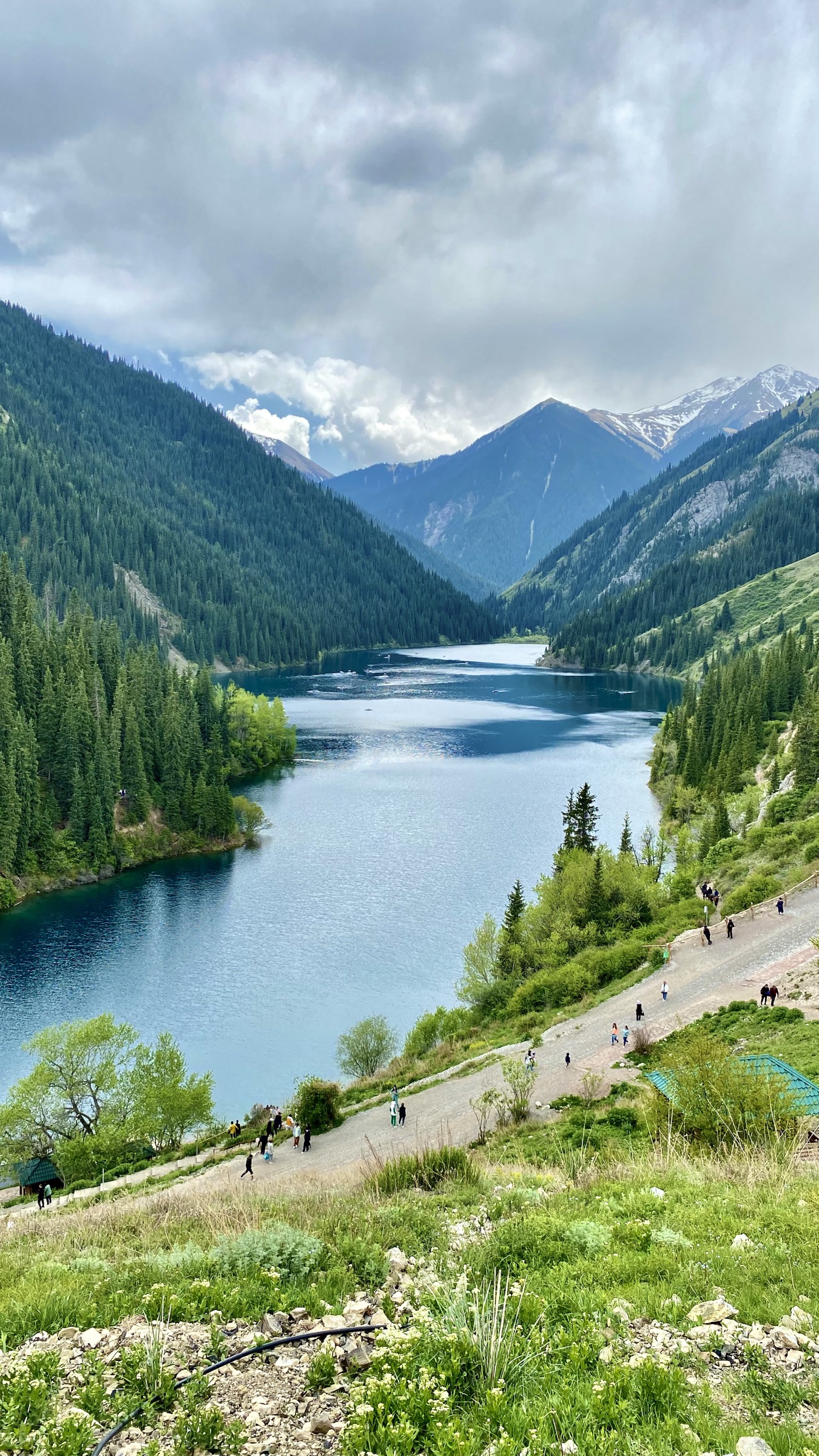
3. Kolsai Lake 1 to Middle Kolsai Lake
Snapshot
Itinerary
From the Lower Kolsai visitor area, the trail follows the west side of the lower lake, then climbs through Tian Shan spruce forest and river-side terrain towards Middle Kolsai. The ascent is steady and can be muddy, with roots, horse traffic, and slippery sections. The middle lake sits in a quieter alpine basin below steeper forest and mountain slopes.
For a day hike, the practical objective is Middle Kolsai and return. Continuing to the third lake makes the route significantly longer and is better treated as an overnight or very long mountain day rather than part of this catalogue entry.
Why it is essential
The Kolsai Lakes are among Kazakhstan’s signature Tian Shan landscapes. The lower-to-middle lake walk gives the region its classic lake-and-forest hike, with a clear destination, national-park setting, and scenery distinct from the Almaty city-edge gorges.
Equipment
- Sturdy boots
- Rain layer and warm layer
- Sun protection
- Food, water or water-treatment method
- Map/GPS and trekking poles
- Cash or card for national-park fees and local transport
Hazards and notes
- Mud, roots, horse traffic, stream crossings, sudden storms, and early/late-season snow can slow the route.
- The national park has entry rules and protected-area restrictions; camping, fires, horses, drones, and fishing should be checked with park staff.
- Start early if returning the same day.
GPX / KML links
| Source | URL | Format / access | Reuse status |
|---|---|---|---|
| AllTrails: Kolsai Lake 1 — Lake 2 Trail | alltrails.com | Source map / app route | AllTrails terms apply; GPX export and reuse terms not verified |
| OpenStreetMap search: Kolsai Lake 1 Lake 2 | openstreetmap.org | Map / search | OSM data is ODbL |
| Visit Almaty: Kolsai Lakes | visitalmaty.kz | Official tourism page | Site terms apply; no route-file licence found |
External links
- Visit Almaty — Kolsai Lakes
- Kazakh Tourism — Kolsai Lakes travel guide
- AllTrails — Kolsai Lake 1 / Lake 2 Trail
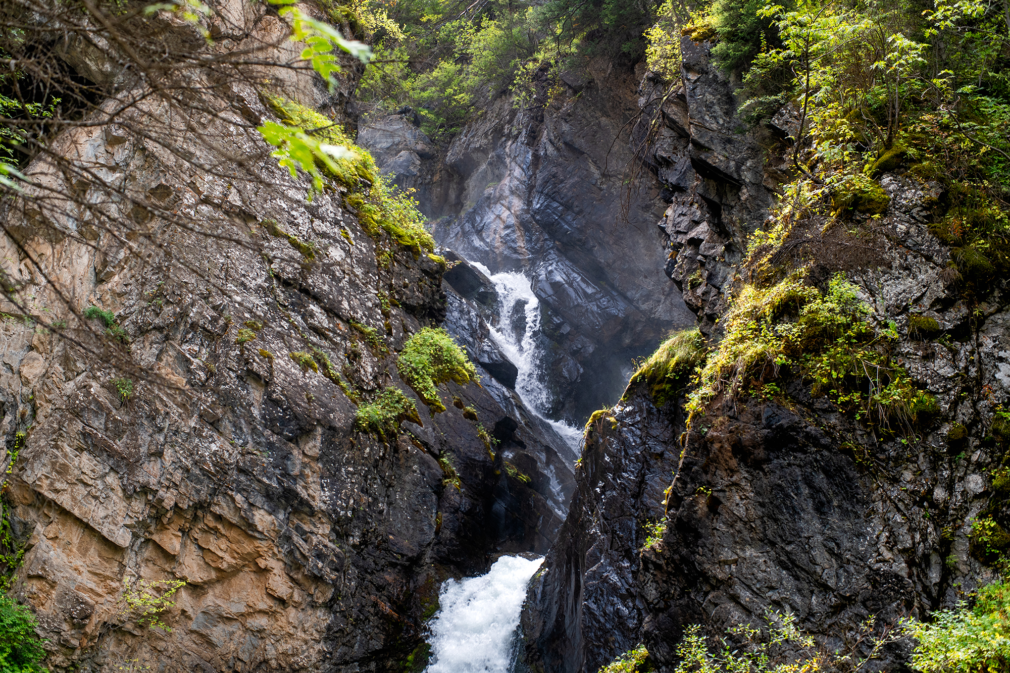
4. Turgen Gorge to Kairak Waterfall
Snapshot
Itinerary
From the Turgen Gorge road end or Batan area, the route follows the valley towards the Kairak River / Bozgul side drainage. The approach is mostly a dirt-road and trail walk through forested gorge scenery, with the last section becoming steeper, muddier, and more enclosed near the waterfall.
Kairak is the largest and most time-consuming of the commonly visited Turgen waterfalls. The route should not be confused with the much shorter Bear / Medvezhiy Waterfall walk near the lower visitor area.
Why it is essential
Kairak Waterfall adds a major gorge-and-waterfall hike to the Kazakh Tian Shan selection. It represents the wetter, forested Turgen side of Ile-Alatau National Park rather than the drier Almaty-facing ridges.
Equipment
- Sturdy boots (waterproof footwear useful after rain)
- Waterproof and warm layers
- Water and food
- Map/GPS and trekking poles
- Power bank
Hazards and notes
- The path can be muddy and slippery, with small stream crossings and a steeper final approach.
- Road access into Turgen Gorge can be affected by snow, rockfall, flooding, and seasonal closures.
- National-park fees and protected-area rules apply.
GPX / KML links
| Source | URL | Format / access | Reuse status |
|---|---|---|---|
| AllTrails: Kairak Waterfall Trail | alltrails.com | Source map / app route | AllTrails terms apply; GPX export and reuse terms not verified |
| OpenStreetMap search: Kairak Waterfall Turgen | openstreetmap.org | Map / search | OSM data is ODbL |
| Welcome.kz: Kairak Waterfall | welcome.kz | Guide page | Site terms apply; no route-file licence found |
External links
- QazTravel — Kairak Waterfall
- Welcome.kz — Kairak Waterfall
- Hitched, Hiking & Housesitting — Turgen Gorge, Kazakhstan
- AllTrails — Kairak Waterfall Trail
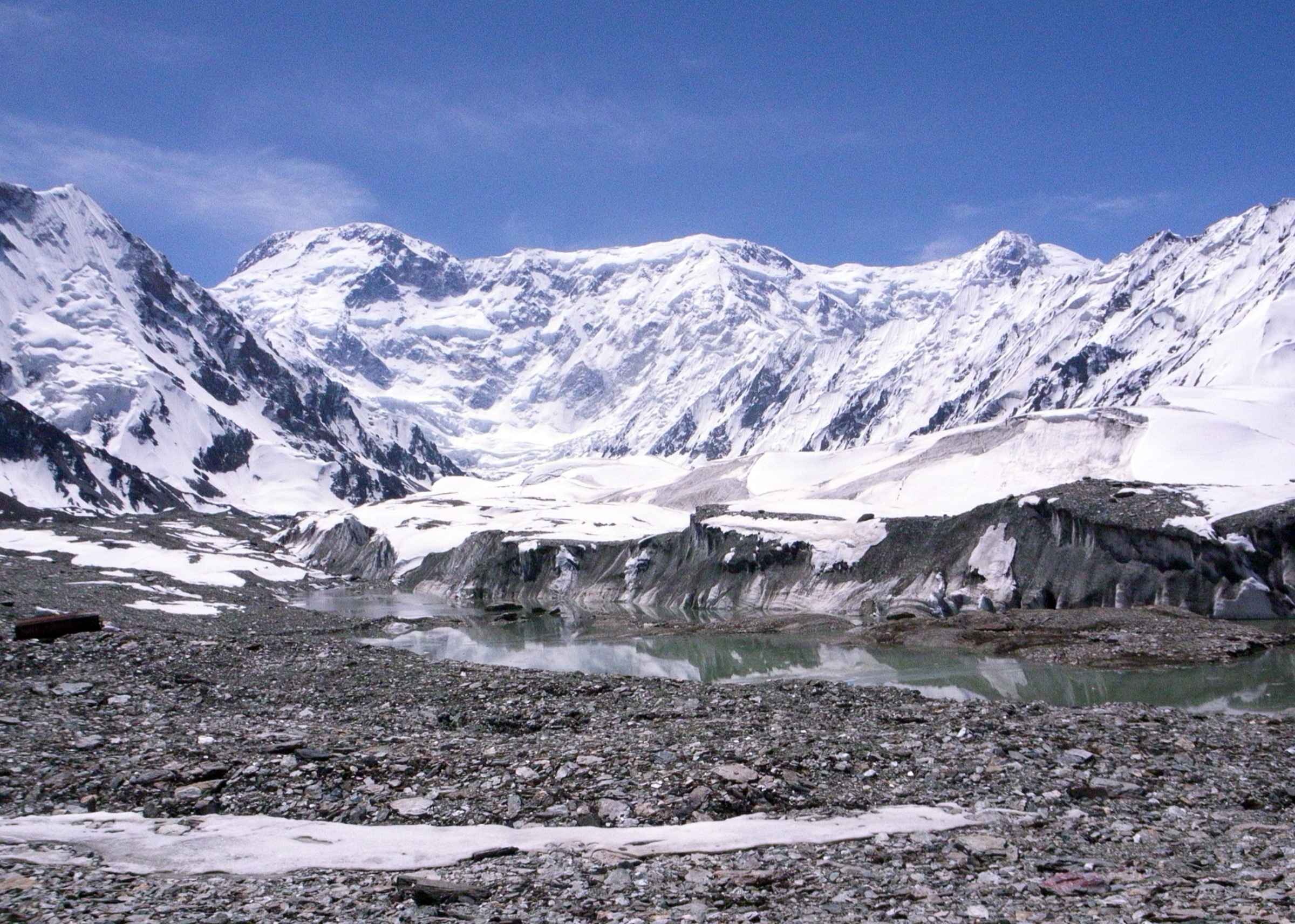
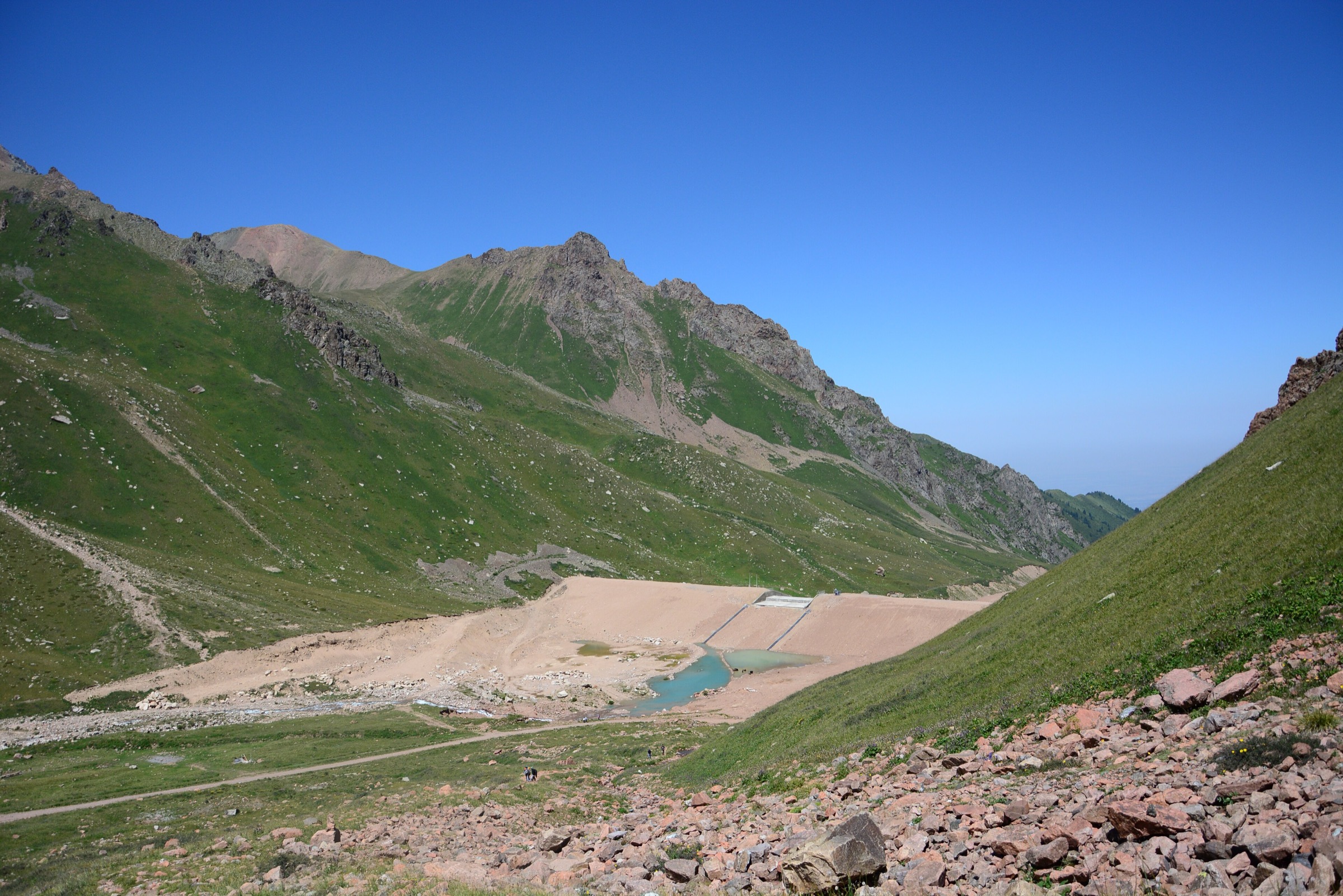
5. Tuyuksu Alpine Camp to T1 / Mynzhylky Glacier View
Snapshot
Itinerary
From Tuyuksu Alpine Camp, the route follows a good dirt road into the high valley towards Mynzhylky and the T1 glacier-view area. The walking is straightforward in clear summer conditions, but the route gains substantial altitude and enters a more severe alpine environment than the lower Almaty gorge hikes.
The return follows the same line. The objective is a glacier-view and high-valley walking day, not a glacier crossing or mountaineering route.
Why it is essential
This is the most direct catalogue route into the high-alpine and glacier-view terrain above Almaty without requiring a technical summit. It balances the lake, meadow, and waterfall walks with the region’s mountaineering landscape around Tuyuksu.
Equipment
- Sturdy boots
- Warm layer and waterproof/windproof shell
- Hat and gloves outside midsummer
- Sun protection
- Water and food
- Map/GPS, power bank, headtorch
- Trekking poles
- Microspikes if snow or ice remains on the track
Hazards and notes
- Altitude, sun exposure, cold wind, sudden storms, snow patches, rockfall from side slopes, and navigation problems in cloud are the main issues.
- Do not step onto glacier ice without appropriate mountaineering equipment and skills.
- The official route page lists all-year seasonality, but winter and spring conditions can require snow travel judgement.
GPX / KML links
| Source | URL | Format / access | Reuse status |
|---|---|---|---|
| Visit Almaty Route no. 132 | visitalmaty.kz | Official route page / source map coordinates | Site terms apply; no downloadable GPX licence found |
| OpenStreetMap search: Tuyuksu T1 Mynzhylky | openstreetmap.org | Map / search | OSM data is ODbL |
External links
Missing data and follow-up
- No official downloadable GPX/KML file was found for any of the five routes in this pass.
- Big Almaty Lake route distance varies substantially between AllTrails and AlmatyHiking because of start-point and variant differences.
- Kolsai Lake 1-2 elevation gain varies between lake-elevation-based guide descriptions and AllTrails source-map statistics.
- Kairak Waterfall route length varies because AllTrails reports a point-to-point line while guide sources describe the return hike from Batan.
- Big Almaty Lake border-zone, water-protection, road-closure, and identity-check rules need current local confirmation before publication.
External links
| Source | URL |
|---|---|
| Visit Almaty — official tourism portal | visitalmaty.kz |
| Visit Almaty — mountain overview / top hiking routes | mountain.visitalmaty.kz |
| Visit Almaty — Kok Zhailau | visitalmaty.kz |
| Visit Almaty — Kolsai Lakes | visitalmaty.kz |
| Visit Almaty — Route no. 132 (Tuyuksu / T1) | visitalmaty.kz |
| AlmatyHiking — Big Almaty Lake | almatyhiking.kz |
| AlmatyHiking — Kok-Zhailau | almatyhiking.kz |
| Kazakh Tourism — Kolsai Lakes travel guide | kazakh.travel |
| QazTravel — Kairak Waterfall | qaztravel.kz |
| Welcome.kz — Kairak Waterfall | welcome.kz |
| Hitched, Hiking & Housesitting — Turgen Gorge | hitchedandhiking.com |
| AllTrails — Big Almaty Lake Loop | alltrails.com |
| AllTrails — Kolsai Lake 1 / Lake 2 Trail | alltrails.com |
| AllTrails — Kairak Waterfall Trail | alltrails.com |