Regional overview
Southern Italy’s mountain hiking is split between several very different landscapes: limestone coastal ridges above the Amalfi Coast, the high forested massifs of Pollino and Aspromonte, and Sicily’s volcanic and karst uplands. The region’s walking character ranges from short, exposed coastal balcony paths to long, remote mountain routes where navigation and self-sufficiency matter.
Pollino National Park forms a large Calabrian-Lucanian Apennine area of ridges, beech forests, high pastures and Bosnian pine landscapes. Aspromonte, at the southern end of Calabria, is recognised as a UNESCO Global Geopark and is known for abrupt relief, forested highlands and long views between the Ionian and Tyrrhenian seas.
Sicily adds two contrasting mountain environments: Etna, an active stratovolcano and UNESCO World Heritage site, and the Madonie limestone mountains, where Pizzo Carbonara is the island’s second-highest summit after Etna. Access varies strongly: Amalfi and Etna have public-transport options, while Pollino, Aspromonte and the Madonie often require a car, transfer, or locally arranged transport.
The safest general season is spring to autumn, with lower coastal routes best outside peak summer heat. Higher routes can hold snow or ice in winter and early spring. Etna is a special case: access to upper zones is controlled by volcanic-risk ordinances, and official park material states that access limits and guide requirements may change according to volcanic activity.
Selection rationale
These five hikes were selected to represent the region’s main hiking identities: one world-famous coastal balcony path, one Etna volcanic summit route, one Pollino high-ridge and Bosnian-pine route, one Aspromonte summit traverse, and one Sicilian limestone high-mountain route. The set avoids clustering all hikes around Etna or the Amalfi Coast and balances iconic status with regional coverage.
Summary table
| # | Hike | Route type | Distance | Gain | Max elevation | Difficulty |
|---|---|---|---|---|---|---|
| 1 | Sentiero degli Dei — Bomerano to Nocelle | Point-to-point coastal balcony | 5.2–7.8 km | +184–329 m | ~655 m | Easy to moderate |
| 2 | Etna Summit Craters from Rifugio Sapienza | Lift/4x4-assisted volcanic summit | ~8 km walking | ~+490 m | ~3,340 m | Hard; guided access required |
| 3 | Serra di Crispo and the Giardino degli Dei | Loop or out-and-back | 11.6–16.7 km | +500–788 m | ~2,051–2,054 m | Moderate to hard |
| 4 | Gambarie to Montalto — Sentiero Calabria | Point-to-point / summit | 14.22 km | +474 m | 1,956 m | E |
| 5 | Pizzo Carbonara from Piano Battaglia | Loop or out-and-back | 7.2–7.6 km | +330–360 m | 1,979 m | Moderate to EE |
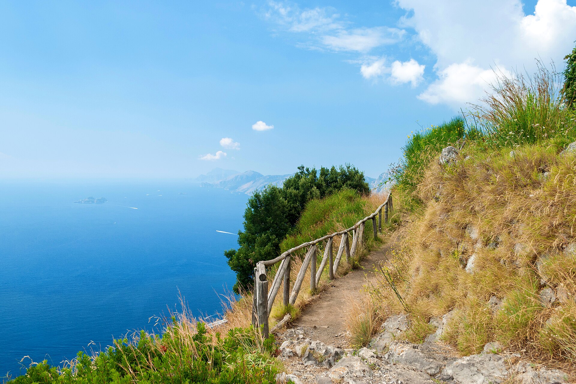
1. Sentiero degli Dei — Bomerano to Nocelle
Snapshot
Itinerary
The route starts in Bomerano, above Agerola, and follows the CAI 327 / Sentiero degli Dei across the limestone slopes high above the Amalfi Coast. The path traverses cliffs, terraces and open viewpoints towards Praiano, Positano and the sea before reaching Nocelle. From Nocelle, descent to Positano can be made by a long staircase of more than 1,800 steps, or by local bus where operating.
Why it is essential
This is the defining coastal mountain walk of the Amalfi Coast and one of southern Italy’s most recognisable hiking routes. It represents the Monti Lattari landscape: steep limestone, village-to-village paths, sea views and historic mule-track terrain.
Equipment
- Hiking shoes or boots
- Water
- Sun protection
- Food
- Weatherproof layer
- Map/GPS
- Trekking poles useful for the descent to Nocelle or Positano
Hazards and notes
The route is not technically difficult, but the cliffside terrain is exposed in places and unsuitable for vertigo. The path should be avoided in storms, strong winds, heavy rain or very hot conditions. Water availability is limited on the route; start with enough water. Seasonal or weather-related closures should be checked locally before departure.
GPX / KML links
| Source | URL | Format | Notes |
|---|---|---|---|
| Zustrack — CAI 327 Sentiero degli Dei | zustrack.com | GPX download indicated / source route page | Terms not resolved; route source found, reuse unresolved |
| OpenStreetMap relation 4757514 | openstreetmap.org | OSM route relation | ODbL; reusable subject to ODbL terms |
| Wikiloc — Bomerano, Nocelle, Positano variant | wikiloc.com | GPS route source | Platform terms not resolved; route-source only |
Sources
- Positano.com — Il Sentiero degli Dei
- Zustrack — CAI 327 Sentiero degli Dei
- OpenStreetMap relation 4757514
- Wikimedia Commons — Sentiero degli Dei 01
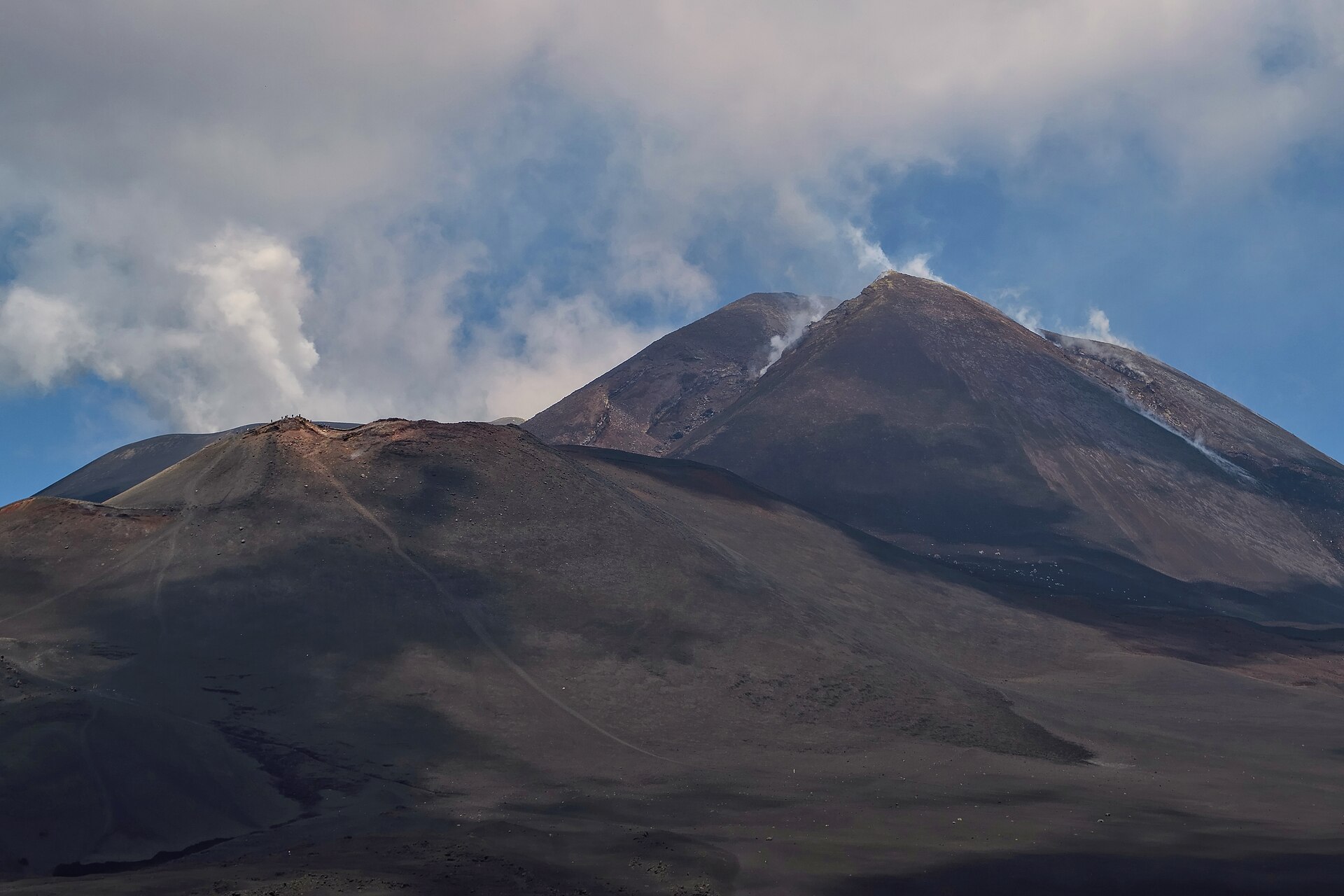
2. Etna Summit Craters from Rifugio Sapienza
Snapshot
Itinerary
The standard southern summit-crater itinerary starts at Rifugio Sapienza and uses the cable car and off-road vehicles to reach the upper volcanic slopes, around 2,850–2,900 m. From there, the route continues on foot to the summit-crater area, then descends over volcanic ash and lava terrain towards the upper cable-car station before returning to Rifugio Sapienza.
Why it is essential
Etna is Europe’s most iconic active volcano landscape and a UNESCO World Heritage site. This route is the classic way for fit walkers to experience the summit-crater environment without undertaking an alpinism route, while still requiring professional guidance and strict respect for current volcanic restrictions.
Equipment
- Sturdy boots
- Warm and windproof layers
- Gloves and hat outside midsummer
- Sun protection
- Food
- Water
- Headtorch as backup
- Navigation backup
- Helmet or other safety equipment if required by guide instructions or ordinance
- Winter equipment may be required in snow or ice
Hazards and notes
Etna is an active volcano. Access to summit altitudes changes according to volcanic risk, ordinances and guide restrictions. Ash, sulphurous gases, strong wind, whiteout, snow and sudden route closures are material hazards. This route should not be treated as a self-guided normal hike above the permitted free-access altitude.
GPX / KML links
| Source | URL | Format | Notes |
|---|---|---|---|
| Guide Alpine Etna Sud — summit-crater itinerary | guidevulcanologicheetna.it | Source itinerary / guided route description | Reuse terms not stated; useful for verifying itinerary, not a reusable route file |
| Guide Alpine Etna Sud / Etna Guide — summit craters | etnaguide.eu | Source itinerary / guided route description | Reuse terms not stated; useful for verifying itinerary |
| Wikiloc — Etna Summit, Rifugio Sapienza | wikiloc.com | GPS route source | Platform terms not resolved; legality depends on ordinances and guided access |
| Parco dell’Etna ordinances | parcoetna.it | Regulatory source | Official public information; use to verify current access rules, not route geometry |
Sources
- Etna Guide — Summit craters
- Guide Vulcanologiche Etna — Summit craters
- Parco dell’Etna ordinances
- Parco dell’Etna ordinanze-sindaci
- UNESCO World Heritage listing — Mount Etna
- AST Sicilia — Catania to Etna bus
- Wikimedia Commons — Summit craters of Mount Etna
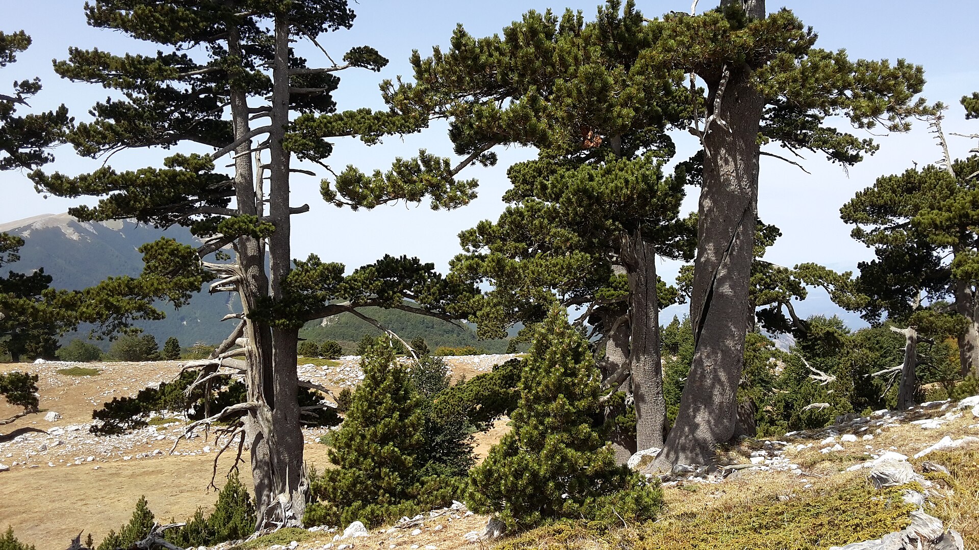
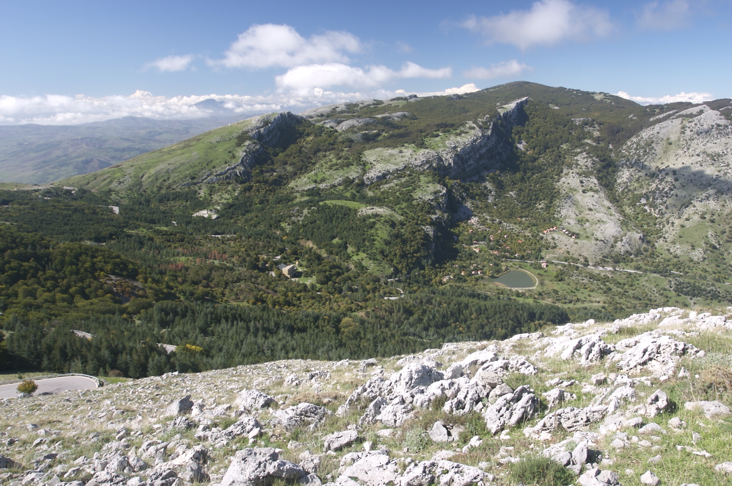
3. Serra di Crispo and the Giardino degli Dei
Snapshot
Itinerary
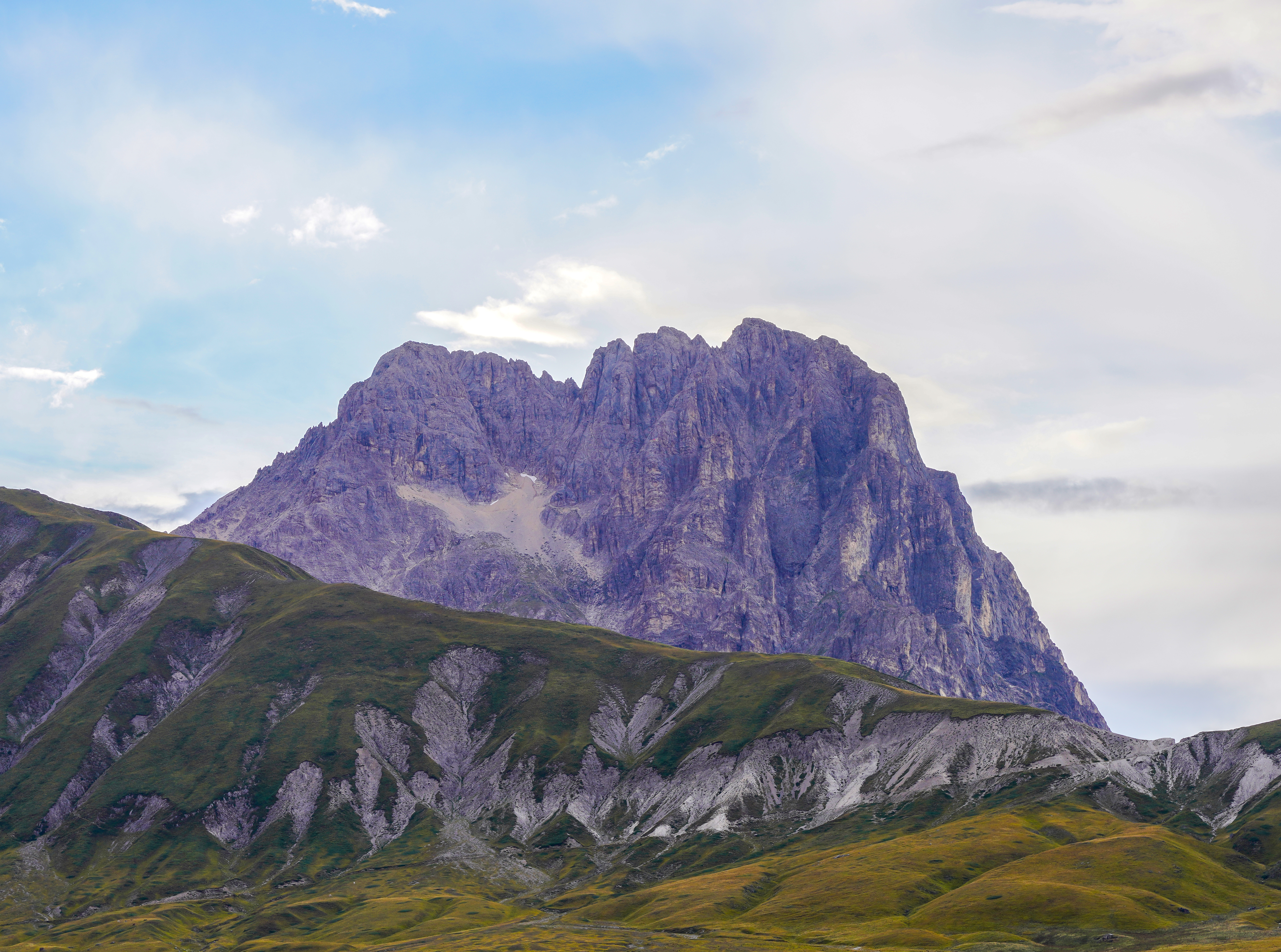
The route crosses the high Pollino landscape towards the Serra di Crispo ridge and the Giardino degli Dei, an area known for Bosnian pines set among open highland terrain. The official park description describes the traverse of the Piani del Pollino towards the Grande Porta, then the Giardino degli Dei and the Serra di Crispo ridge, with wide views towards the Ionian side and Basilicata. Loop variants from Colle dell’Impiso add a longer approach through forest and high pastures before reaching the ridge.
Why it is essential
This hike represents the Pollino massif at its most characteristic: high Apennine ridges, beech woods, open uplands and the celebrated Bosnian pines. It also gives a more remote counterpoint to the better-known coastal and Etna hikes in this catalogue.
Equipment
- Sturdy boots
- Trekking poles
- Warm layer
- Weatherproof shell
- Map/GPS
- Navigation backup
- Food
- Ample water
- Microspikes may be needed if snow or ice remains
Hazards and notes
Navigation can be difficult in cloud, especially on open upland and karst-like terrain. The route is more remote than Amalfi or Etna, with limited services and limited water. Snow, ice and wind can make the ridge substantially more serious outside the main hiking season. Local park conditions and trail access should be checked before departure.
GPX / KML links
| Source | URL | Format | Notes |
|---|---|---|---|
| Official Pollino National Park route description | parcopollino.gov.it | Official route description/source page | Explicit route-file terms not found; no official GPX found |
| Pollino Park excursions page | parcopollino.it | Official route description/source page | Explicit route-file terms not found; no official GPX found |
| Komoot — Serra di Crispo / Giardino degli Dei loop | komoot.com | Route map/source | Platform terms not resolved; route-source only |
| Wikiloc — Colle Impiso, Serra di Crispo, Giardino degli Dei | wikiloc.com | GPS route source | Platform terms not resolved; route-source only |
Sources
- Parco Nazionale del Pollino
- Pollino Park excursions
- Parco Pollino official
- Komoot — Serra di Crispo / Giardino degli Dei
- Wikiloc — Colle Impiso, Serra di Crispo, Giardino degli Dei
- Wikimedia Commons — Massiccio del Pollino, Serra di Crispo
4. Gambarie to Montalto — Sentiero Calabria
Snapshot
Itinerary
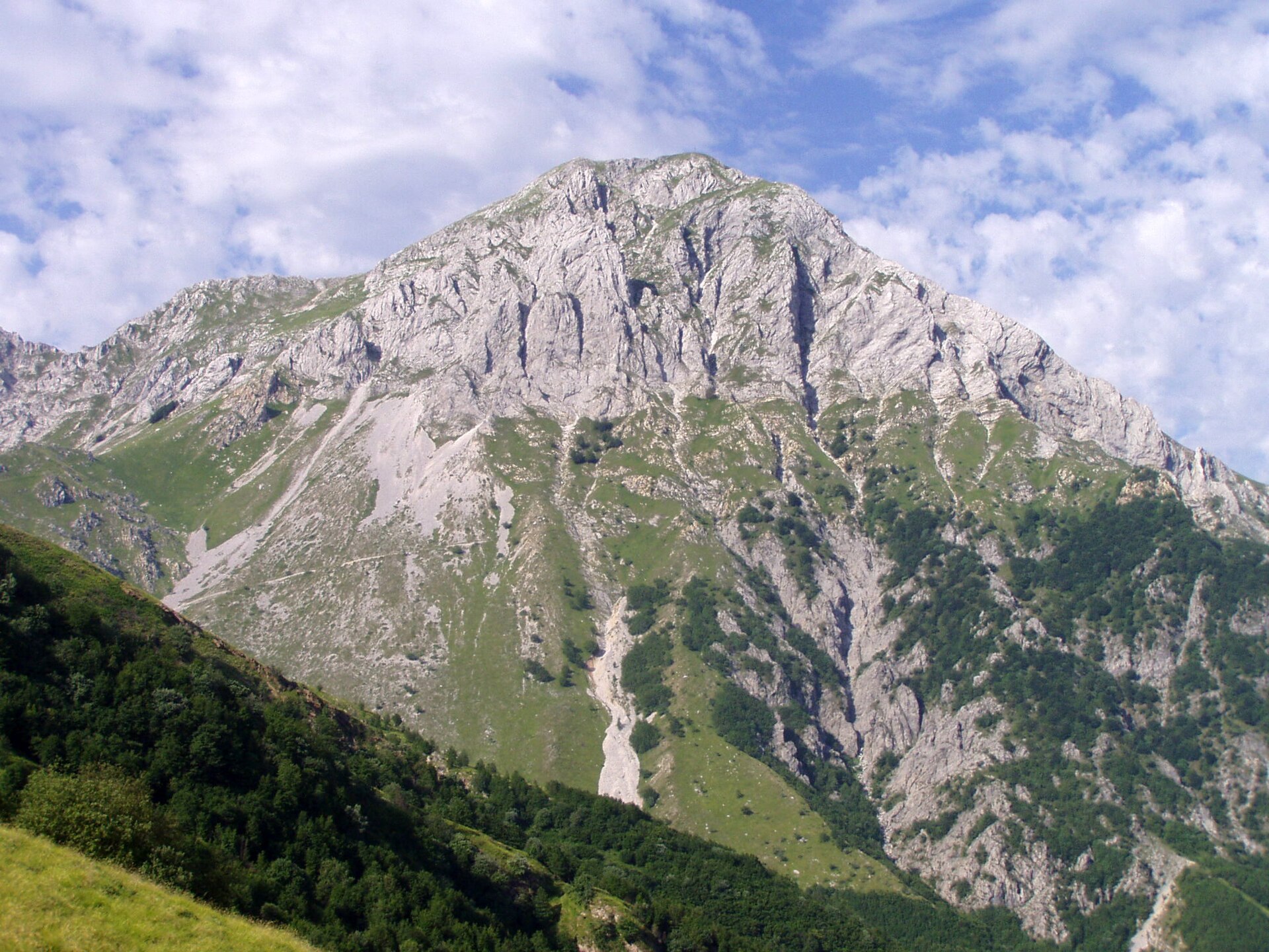
This stage of the Sentiero Calabria leaves Gambarie and climbs through the Aspromonte highlands towards Montalto, the highest summit of the Aspromonte massif. The official park route page gives Gambarie as the start at 1,306 m, Montalto as the finish at 1,956 m, a length of 14.22 km, 474 m of ascent and an estimated walking time of 4 hours.
Why it is essential
Montalto is the symbolic high point of Aspromonte. The route gives a representative crossing of the park’s forested uplands and summit terrain, with the official park description noting wide summit views towards Etna, the Aeolian Islands and both the Ionian and Tyrrhenian sides in clear conditions.
Equipment
- Sturdy boots
- Weatherproof layer
- Warm layer
- Food
- Water
- Map/GPS
- Navigation backup
- Trekking poles useful
- Snow/ice equipment may be needed in winter or early spring
Hazards and notes
The principal unresolved issue is logistics: the official route is point-to-point from Gambarie to Montalto, so a return plan is needed. Weather can change quickly on the exposed upper section, and cloud can reduce navigation reliability. Water sources and transport availability were not verified.
GPX / KML links
| Source | URL | Format | Notes |
|---|---|---|---|
| Aspromonte National Park — Sentiero Calabria, Gambarie to Montalto | parcoaspromonte.gov.it | Official route page / map download indicated | Explicit route-file terms not resolved |
| Aspromonte National Park route page | parconazionaleaspromonte.it | Official route page | Explicit route-file terms not resolved |
| Wikiloc — Gambarie, Montalto, Aspromonte | wikiloc.com | GPS route source | Platform terms not resolved; route-source only |
| Komoot — Montalto, Aspromonte National Park | komoot.com | Route-map variant | Platform terms not resolved; secondary comparison source |
Sources
- Parco Nazionale dell’Aspromonte
- Aspromonte route — Gambarie to Montalto
- Parco Aspromonte official
- Wikiloc — Gambarie, Montalto, Aspromonte
- Komoot — Montalto, Aspromonte National Park
- Wikimedia Commons — Montalto
5. Pizzo Carbonara from Piano Battaglia
Snapshot
Itinerary
The route starts from Piano Battaglia and climbs through the high Madonie landscape towards Pizzo Carbonara, Sicily’s second-highest summit after Etna. Common loop variants pass Pizzo Scalonazzo and continue over open limestone, pasture and beech-edge terrain before reaching the Carbonara summit area and returning to Piano Battaglia. The official park route page stresses that this is a demanding high-mountain route and should be undertaken only with excellent visibility.
Why it is essential
Pizzo Carbonara is the key high summit of the Madonie and the most important non-volcanic mountain objective in Sicily. It provides a limestone and karst counterpart to Etna’s volcanic terrain and is central to any balanced Sicily mountain-hiking selection.
Equipment
- Sturdy boots
- Windproof/waterproof layer
- Warm layer
- Sun protection
- Food
- Water
- Map/GPS
- Navigation backup
- Trekking poles useful
- Snow and ice equipment may be required in winter or early spring
Hazards and notes
The Madonie high plateau can be confusing in mist, and the official route page specifically warns that the itinerary should be done in excellent visibility. Limestone holes, rough ground and sudden weather changes are relevant hazards. Water availability was not verified for the full route.
GPX / KML links
| Source | URL | Format | Notes |
|---|---|---|---|
| Parks.it / Madonie Park — Piano Battaglia to Pizzo Carbonara | parks.it | Official route description | Explicit route-file terms not found; no official GPX found |
| Parks.it / Madonie Park route page | parks.it | Official route description | Explicit route-file terms not found; no official GPX found |
| Gaia GPS — Pizzo Carbonara Loop | gaiagps.com | GPX/KML route source indicated | Platform terms not resolved; route-source only |
| Wikiloc — Piano Battaglia, Pizzo Carbonara | wikiloc.com | GPS route source | Platform terms not resolved; route-source only |
| Komoot — Pizzo Scalonazzo / Pizzo Carbonara loop | komoot.com | Route-map variant | Platform terms not resolved; secondary route comparison |
Sources
- Parks.it — Madonie / Pizzo Carbonara (651)
- Parks.it — Madonie / Pizzo Carbonara (3525)
- Gaia GPS — Pizzo Carbonara Loop
- Wikiloc — Piano Battaglia, Pizzo Carbonara
- Komoot — Pizzo Scalonazzo / Pizzo Carbonara loop
- Wikimedia Commons — Pizzo Carbonara
Region-level sources
| Source | URL |
|---|---|
| Pollino National Park | parconazionalepollino.it |
| Pollino Park excursions | parcopollino.it |
| Aspromonte National Park | parconazionaleaspromonte.it |
| Aspromonte route — Gambarie to Montalto | parconazionaleaspromonte.it |
| Parco dell’Etna ordinances | parcoetna.it |
| Etna UNESCO World Heritage listing | whc.unesco.org |
| Sentiero degli Dei route information | positano.com |
| Guide Alpine Etna Sud summit-crater route | etnaguide.eu |
| Madonie Park / Pizzo Carbonara route | parks.it |