Regional overview
The Northern Apennines and Apuan Alps form a varied hiking region across Tuscany and Emilia-Romagna. The Apuan Alps are steep, limestone-based, and unusually close to the Tyrrhenian Sea, with marble quarries, karst caves, sharp ridges, rocky arches, and summit views towards both the coast and the Apennine crest.
The Tuscan-Emilian Apennines have a different character: forested valleys, glacial lakes, long grassy ridges, sandstone cliffs, and rounded summits around 1,700–2,100 m. The Appennino Tosco-Emiliano National Park describes the area as a network of old mule tracks, ridge routes, lakes, and long-distance trails including the Grande Escursione Appenninica and Sentiero Italia.
The normal hiking season is late spring to autumn. In the Apuan Alps, snow is less persistent than on the higher Apennine crest, but wet limestone, exposed ridges, and steep descents can still make routes serious. On the Apennine ridge, snow and cornices can remain into spring, and weather changes quickly above the forest line.
Access is mostly road-based, with trailheads near villages, mountain huts, passes, or car parks. Public transport exists to some towns, but final access to many trailheads is limited and should be checked locally before travel.
Selection rationale
These five hikes were selected to represent the region’s main hiking identities: the iconic limestone arch of Monte Forato, the major Apuan summit of Pania della Croce, the high Apennine crest and Lago Bargetana around Monte Prado, the lake-and-summit circuit of Monte Ventasso, and the culturally important sandstone cliff of Pietra di Bismantova.
Summary table
| # | Hike | Country | Route type | Distance | Gain | Max elevation | Difficulty | Verification |
|---|---|---|---|---|---|---|---|---|
| 1 | Monte Forato from Fornovolasco | Italy | Loop | 10.5 km | 842 m | 1,278 m | Hard | Partially verified |
| 2 | Pania della Croce from Piglionico | Italy | Out-and-back, with loop variants | 8.2–9.5 km | 752–814 m | 1,857–1,858 m | Hard | Partially verified |
| 3 | Monte Prado and Lago Bargetana from Case di Civago | Italy | Loop | 20.1–20.5 km | 1,086–1,120 m | 2,054 m | Hard | Partially verified |
| 4 | Monte Ventasso and Lago Calamone | Italy | Loop | 6.1–6.9 km for Lago Calamone variants; official Pratizzano distance not stated | 414–421 m for Lago Calamone variants; official Pratizzano route gives 650 m | 1,727 m | Hard on AllTrails; E on official park route | Partially verified |
| 5 | Pietra di Bismantova circuit | Italy | Loop | 4.7 km | 280–285 m | 1,046 m | Moderate / T+ | Partially verified |
1. Monte Forato from Fornovolasco
Snapshot
Itinerary
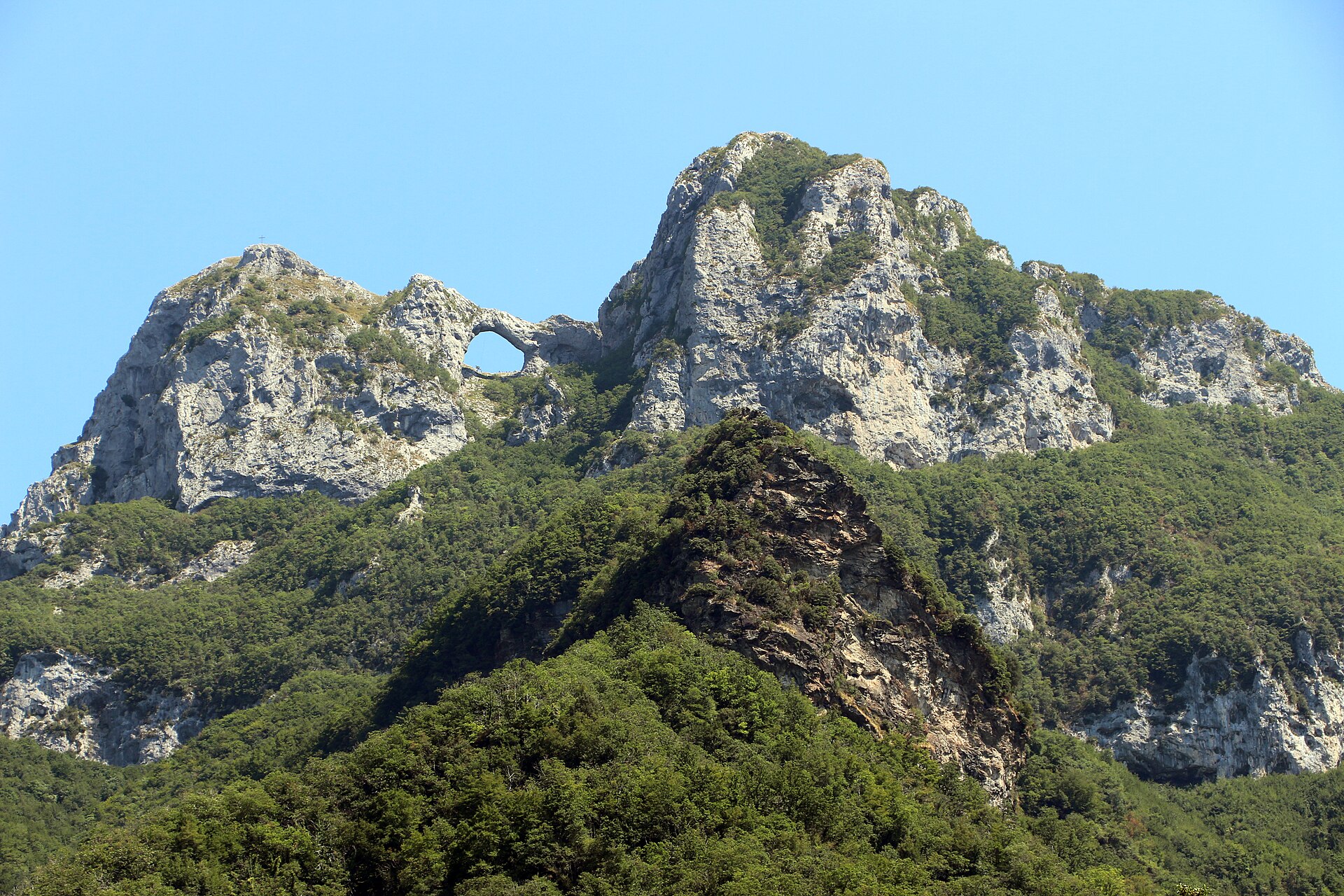
The route starts in Fornovolasco and climbs into the limestone terrain of the southern Apuan Alps. It passes forest, karst features, and steep rocky ground before reaching the natural arch of Monte Forato. The route can be continued towards Foce di Valli before descending back towards Fornovolasco. Tuscany’s official tourism material identifies the Monte Forato circular route from Fornovolasco as one of the best-known hiking routes in the Apuan Alps and notes the Tana che urla cave and the rocky arch as key features. AllTrails gives the Fornovolasco loop as 10.46 km with 842 m of ascent, hard difficulty, and a maximum elevation of about 1,278 m.
Why it is essential
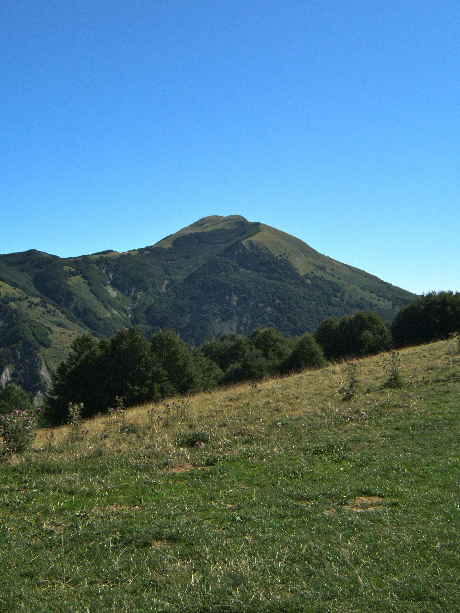
Monte Forato is one of the signature Apuan Alps hikes because of its natural stone arch, compact but rugged limestone terrain, and views across the Garfagnana and Apuan ridges. It represents the karst and rocky character of the range better than a standard forest or ridge walk.
Equipment
- Mountain hiking equipment
- Sturdy boots
- Weatherproof layer
- Warm layer
- Water
- Food
- Map/GPS
- Sun protection
- Trekking poles recommended for steep or slippery descents
Hazards and notes
The route includes steep ground, rocky limestone, and potentially slippery descents. Some variants in the area include exposed or more technical sections; avoid via ferrata or scrambling variants unless carrying appropriate equipment and experience. Early or late season conditions should be checked locally.
GPX / KML links
| Source | URL | Format | Notes |
|---|---|---|---|
| AllTrails | alltrails.com | Source map / app route | Platform terms; direct reuse not confirmed. Suitable as source reference; geometry will be replaced later |
| Wikiloc, Alto Matanna variant | it.wikiloc.com | GPX download visible on page | Wikiloc terms; reuse not confirmed. Useful route source for manual comparison; geometry will be replaced later |
Sources
- Tuscany official tourism, Monte Forato route description
- AllTrails, Monte Forato from Fornovolasco route
- Wikimedia Commons, Monte Forato image
- Wikiloc, Monte Forato Alto Matanna variant
2. Pania della Croce from Piglionico
Snapshot
Itinerary
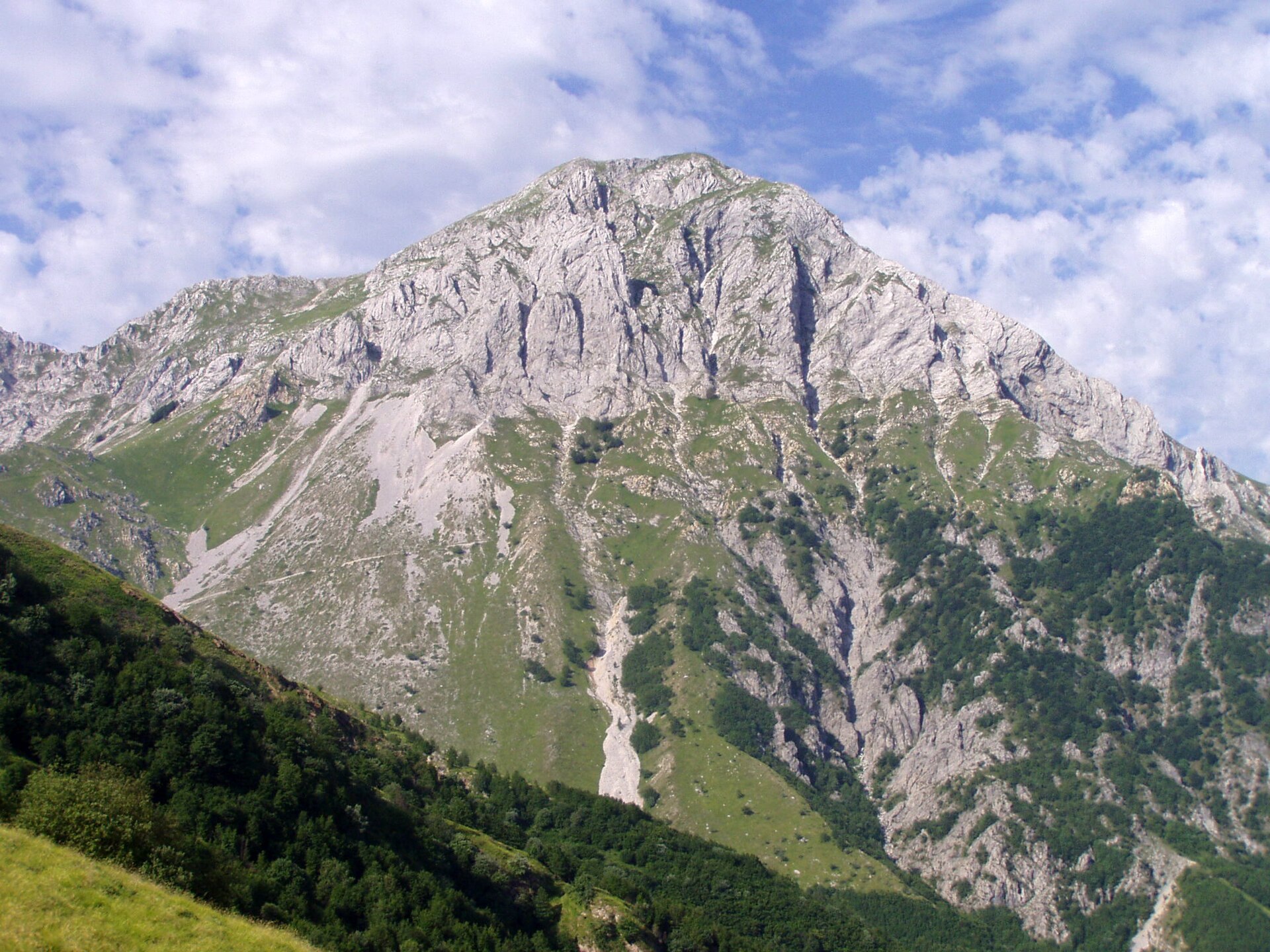
The normal route starts near Foce del Piglionico and climbs towards Rifugio Enrico Rossi. From the hut area, the route continues by Focetta del Puntone and through the Vallone dell’Inferno to reach the summit of Pania della Croce. The summit is one of the highest and most recognisable points in the Apuan Alps. AllTrails records the Piglionico route as 8.2 km with 752 m of ascent and hard difficulty. A Wikiloc loop variant from Piglionico records 9.49 km, 814 m of ascent and descent, and a maximum elevation of 1,857 m.
Why it is essential
Pania della Croce is a classic Apuan Alps summit. The route combines beech forest, a mountain hut, limestone slopes, and wide views across the Apuan chain and towards the coast. It is more summit-focused than Monte Forato and gives a stronger sense of the height and exposure of the central Apuan Alps.
Equipment
- Mountain hiking equipment
- Sturdy boots
- Weatherproof layer
- Warm layer
- Food
- Water
- Map/GPS
- Trekking poles recommended
- Microspikes may be useful if snow remains early in the season
Hazards and notes
The upper route is steep and rocky, with sections requiring care in wet or windy conditions. The Vallone dell’Inferno and summit slopes are more serious than the modest distance suggests. Early season snow or ice can make the route unsuitable without winter equipment.
GPX / KML links
| Source | URL | Format | Notes |
|---|---|---|---|
| AllTrails | alltrails.com | Source map / app route | Platform terms; direct reuse not confirmed. Suitable as source reference; geometry will be replaced later |
| Wikiloc | it.wikiloc.com | GPX download visible on page | Wikiloc terms; reuse not confirmed. Useful route source for manual comparison; geometry will be replaced later |
Sources
- AllTrails, Foce del Piglionico to Pania della Croce
- Wikiloc, Pania della Croce from Piglionico
- Wikimedia Commons, Pania della Croce CC BY-SA 4.0 image
- Wikimedia Commons / Flickr import, Pania della Croce CC BY-SA 2.0 image
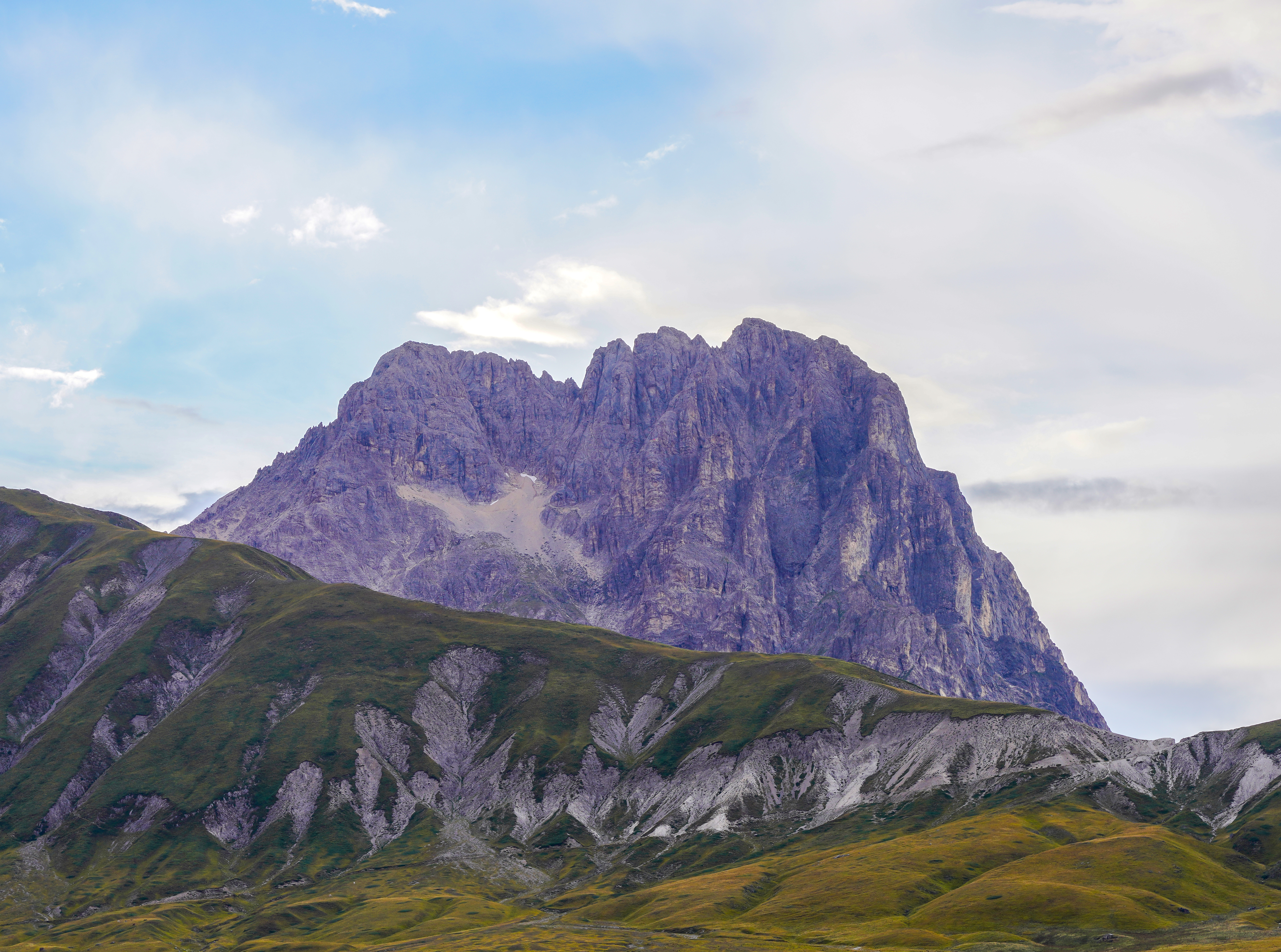
3. Monte Prado and Lago Bargetana from Case di Civago
Snapshot
Itinerary
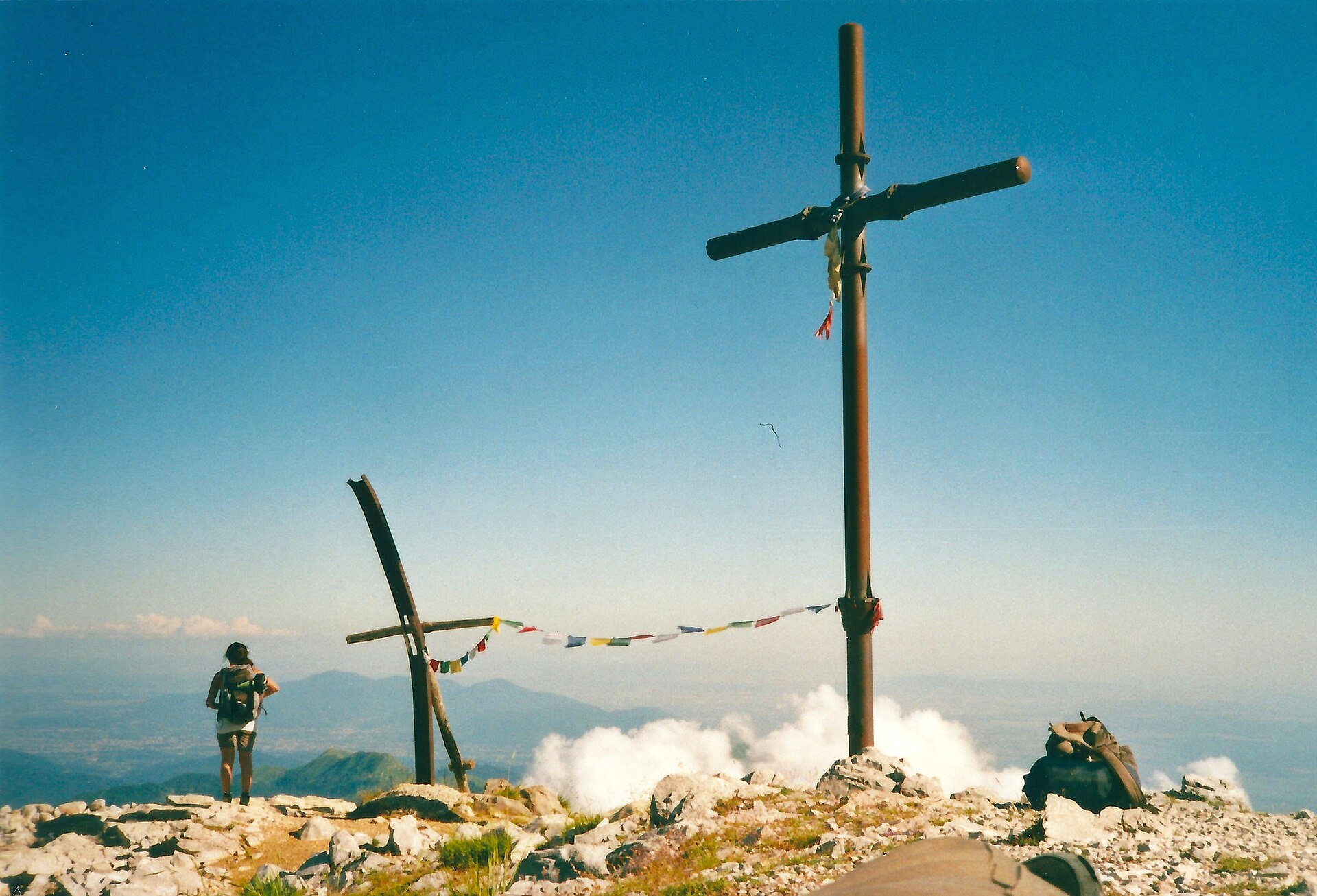
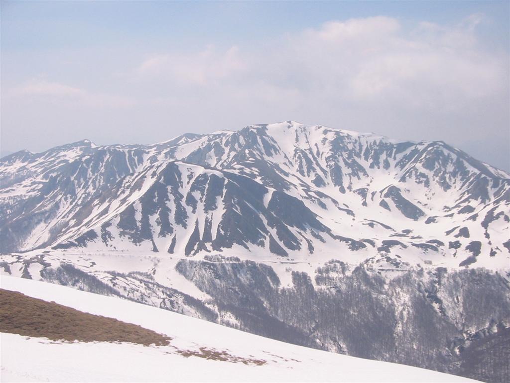
The route starts from the Alta Val Dolo side near Case di Civago and climbs through forest and the Abetina Reale area towards Lago Bargetana. It then ascends open slopes and ridge terrain to Monte Prado, the highest summit in Tuscany and one of the major high points of the northern Apennine crest. The return can follow the Alta Via dei Parchi / ridge and valley tracks via Passo delle Forbici back towards the Dolo valley. Wikiloc records the Civago loop as 20.11 km with 1,086 m of ascent. Komoot records a similar Alta Val Dolo loop from Case di Civago as 20.5 km with 1,120 m of climbing and a time of 7 h 37 min.
Why it is essential
Monte Prado is the high mountain representative of this region. The route combines ancient forest, Lago Bargetana, open summit slopes, and a long section of Apennine ridge. It provides a different landscape from the Apuan Alps: broader, higher, more remote, and more exposed to mountain weather.
Equipment
- Full mountain hiking equipment
- Sturdy boots
- Trekking poles
- Weatherproof layer
- Warm layer
- Navigation backup
- Headtorch
- Food
- Sufficient water
- Microspikes may be needed if snow remains on the crest
Hazards and notes
This is a long, committing day. Navigation becomes more important above the forest line, especially in cloud. Komoot flags a short section of the loop as potentially dangerous, technical, or hazardous, requiring specialist equipment or previous experience; this section should be checked against local CAI maps before travel.
GPX / KML links
| Source | URL | Format | Notes |
|---|---|---|---|
| Wikiloc | fr.wikiloc.com | GPX download visible on page | Wikiloc terms; reuse not confirmed. Useful route source for manual comparison; geometry will be replaced later |
| Komoot | komoot.com | Source map / app route | Komoot terms; direct reuse not confirmed. Suitable as source reference; geometry will be replaced later |
| Appennino Tosco-Emiliano National Park | parks.it | Official source-map itinerary | Official reuse terms not confirmed. Useful for route validation and manual mapping |
Sources
- Wikiloc, Monte Prado loop
- Komoot, Alta Val Dolo loop from Case di Civago
- Appennino Tosco-Emiliano National Park, Monte Prado traverse stage
- Wikimedia Commons, Monte Prado image
4. Monte Ventasso and Lago Calamone
Snapshot
Itinerary
The official national park route starts at Rifugio Pratizzano and follows a circuit through Lago Calamone, Santa Maria Maddalena, and the summit of Monte Ventasso before returning to Pratizzano. The park gives 4 hours, 650 m of ascent, a maximum elevation of 1,727 m, and a recommended season from June to October. Shorter Lago Calamone variants are recorded by AllTrails as 6.1–6.9 km loops or out-and-back routes, with about 414–421 m of ascent.
Why it is essential
Monte Ventasso gives a compact introduction to the Reggio Emilia side of the northern Apennines: a glacial lake, forest, summit grassland, and a broad panorama from a moderate-height peak. It balances the more severe Apuan limestone routes and the longer Monte Prado day.
Equipment
- Standard to mountain hiking equipment
- Hiking boots
- Weatherproof layer
- Warm layer
- Water
- Food
- Map/GPS
- Sun protection
- Trekking poles recommended if descending steep or muddy paths
Hazards and notes
The route is less committing than Monte Prado but still reaches an exposed summit. Mist can reduce visibility on the upper slopes. Snow may remain outside the recommended summer/autumn season. Access roads and any parking restrictions around Lago Calamone or Pratizzano should be checked locally.
GPX / KML links
| Source | URL | Format | Notes |
|---|---|---|---|
| Appennino Tosco-Emiliano National Park | parks.it | Official source-map itinerary | Official reuse terms not confirmed. Useful for route validation and manual mapping |
| AllTrails, Lago Calamone loop | alltrails.com | Source map / app route | Platform terms; direct reuse not confirmed. Suitable as source reference; geometry will be replaced later |
| AllTrails, south ridge variant | alltrails.com | Source map / app route | Platform terms; direct reuse not confirmed. Suitable as source reference; geometry will be replaced later |
Sources
- Appennino Tosco-Emiliano National Park, official Monte Ventasso itinerary
- AllTrails, Lago Calamone–Monte Ventasso
- AllTrails, Lago Calamone–Monte Ventasso south ridge
- Wikimedia Commons, Monte Ventasso image
5. Pietra di Bismantova circuit
Snapshot
Itinerary
The route starts at Piazzale Dante below the Pietra di Bismantova and climbs to the plateau and surrounding paths. The official park itinerary links Piazzale Dante, Pietra di Bismantova, Campo Pianelli, and the return to Piazzale Dante. The park gives 2 h 30 min, 280 m of ascent, a maximum elevation of 1,046 m, and a recommended season from March to November. AllTrails records the circuit as 4.67 km with 285 m of ascent, moderate difficulty, and a loop route within the Appennino Tosco-Emiliano National Park.
Why it is essential
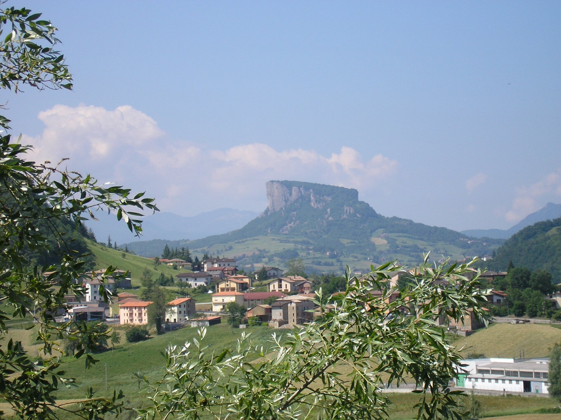
Pietra di Bismantova is one of the most recognisable landmarks in the northern Apennines: a sheer sandstone mesa above Castelnovo ne’ Monti, with cultural importance as well as hiking value. The park notes its status as a natural monument and its association with Dante’s Divina Commedia.
Equipment
- Standard hiking equipment
- Hiking shoes with good grip
- Weatherproof layer
- Water
- Food
- Sun protection
- Map/GPS
Hazards and notes
The main walking route is short, but cliff edges are serious and should be avoided in poor visibility, wind, or wet conditions. The area is also used for climbing, so walkers should stay on marked paths and avoid entering climbing lines or unstable cliff-base areas.
GPX / KML links
| Source | URL | Format | Notes |
|---|---|---|---|
| Appennino Tosco-Emiliano National Park | parks.it | Official source-map itinerary | Official reuse terms not confirmed. Useful for route validation and manual mapping |
| AllTrails | alltrails.com | Source map / app route | Platform terms; direct reuse not confirmed. Suitable as source reference; geometry will be replaced later |
Sources
- Appennino Tosco-Emiliano National Park, official Pietra di Bismantova itinerary
- AllTrails, Pietra di Bismantova
- Wikimedia Commons, Pietra di Bismantova public-domain image
Region-level sources
| Source | Use | URL |
|---|---|---|
| Tuscany official tourism, Apuan Alps hiking overview and Monte Forato route | Apuan Alps context | visittuscany.com |
| Appennino Tosco-Emiliano National Park, official trekking overview | Apennine park context | parcoappennino.it |
| Appennino Tosco-Emiliano National Park, Monte Ventasso itinerary | Monte Ventasso route | parks.it |
| Appennino Tosco-Emiliano National Park, Pietra di Bismantova itinerary | Bismantova route | parks.it |
| Appennino Tosco-Emiliano National Park, Monte Prado traverse stage | Monte Prado route | parks.it |
| AllTrails, Monte Forato from Fornovolasco | Monte Forato source map | alltrails.com |
| AllTrails, Pania della Croce from Foce del Piglionico | Pania della Croce source map | alltrails.com |
| AllTrails, Lago Calamone–Monte Ventasso | Monte Ventasso source map | alltrails.com |
| AllTrails, Pietra di Bismantova | Bismantova source map | alltrails.com |
| Wikiloc, Pania della Croce from Piglionico | Pania della Croce GPX source | it.wikiloc.com |
| Wikiloc, Monte Prado Appennino Tosco-Emiliano | Monte Prado GPX source | fr.wikiloc.com |
| Komoot, Alta Val Dolo loop from Case di Civago | Monte Prado route source | komoot.com |