Regional overview
The Kopet Dag and north-east Iranian ranges form a long, dry mountain borderland between Iran and Turkmenistan, with related highlands around Mashhad, Binalud, Hezar Masjed and the Ashgabat foothills. The walking character is mixed: high Iranian summit ascents, waterfall gorges, village paths, long ridge traverses and, on the Turkmenistan side, the built Walk of Health along the Kopet Dag above Ashgabat.
Official, public hiking documentation is limited. Britannica and Wikimedia/OSM-type sources establish the Kopet Dag as the Iran-Turkmenistan border range, while route statistics for named hikes mostly come from Wikiloc GPS records. The Turkmenistan Walk of Health is better described in tourism sources, but detailed ascent and GPX-style data were not found in this pass.
The normal season is spring and autumn for lower slopes and summer for the higher summits, with winter snow and ice possible on Shirbad, Binalud and Hezar Masjed. Summer heat, limited water, exposed scree, border-area controls and access restrictions are important considerations. Turkmenistan travel normally requires visa/tour arrangements; independent access should not be assumed.
Selection rationale
The five hikes cover the main walking characters available from open sources: the highest Binalud/Shirbad summit, a second major Binalud summit route, the Akhlamad waterfall gorge, a Hezar Masjed mountain route, and the Ashgabat Walk of Health in the Kopet Dag foothills.
Summary table
| # | Hike | Country | Route type | Distance | Gain | Max elevation | Difficulty |
|---|---|---|---|---|---|---|---|
| 1 | Shirbad Peak | Iran | Point-to-point / summit route | 14.8 km | 1,134 m | 3,319 m | Moderate-hard |
| 2 | Mount Binalud from Ferizi | Iran | Loop | 22.8 km | 1,692 m | 3,215 m | Very difficult |
| 3 | Akhlamad Waterfall Gorge | Iran | One-way gorge route | 5.5 km | 777 m | 1,841 m | Moderate |
| 4 | Hezar Masjed mountain route | Iran | Point-to-point / long mountain traverse | 25.3 km | 1,265 m | 2,759 m | Difficult |
| 5 | Ashgabat Walk of Health / Nisa section | Turkmenistan | Out-and-back or point-to-point section | 8 km section; full path 36 km by tourism source | Easy-moderate to strenuous by length |
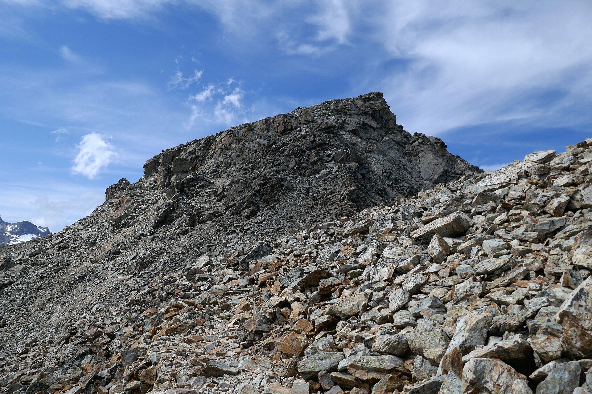
1. Shirbad Peak
Snapshot
Itinerary
The source route climbs from the Binalud foothills toward the Shirbad summit area, passing high waypoints above 3,000 m and a summit waypoint near 3,310 m. The route is published as a point-to-point mountain track; walkers should confirm the intended descent and vehicle logistics before using it.
Why it is essential
Shirbad is listed by Peakbagger as the high point of Razavi Khorasan and is the best-known summit in the Binalud group. It gives the region a clear high-summit hike with public route statistics and an open-licence photo.
Equipment
- Sturdy boots
- Warm/windproof layers
- Sun protection
- Trekking poles
- Headtorch
- Water
- Food
- Navigation backup
- Traction equipment in snow season only if conditions and experience justify the ascent
Hazards and notes
- Altitude, snow, wind, heat on lower slopes and route-finding are the main hazards.
- The cited route is not a simple loop, so transport and descent line require local planning.
GPX / KML links
| Source | URL | Format / access | Reuse status |
|---|---|---|---|
| Wikiloc - Shirbad peak | wikiloc.com | Source route / downloadable trail for users | Wikiloc terms apply; route-file download possible through Wikiloc; reuse terms unresolved |
External links
2. Mount Binalud from Ferizi
Snapshot
Itinerary
The route climbs from Ferizi through the Binalud high country, makes a high loop over or near the Binalud summit area, and returns to the same village side. It is a long, high day with significant ascent and should be treated as a strenuous mountain route rather than a casual walk.
Why it is essential
The Binalud Mountains are one of the principal north-east Iranian ranges and a major hiking area for Mashhad/Neyshabur. Including Binalud alongside Shirbad reflects the broader north-east Iranian range element in the supplied region.
Equipment
- Sturdy boots
- Trekking poles
- Warm layer
- Shell
- Sun protection
- Headtorch
- Food
- Water
- Navigation backup
- Snow equipment when conditions require
Hazards and notes
- The long distance and high gain put this at the strenuous edge of the day-hike specification.
- Weather, altitude, heat and water scarcity should be assessed before departure.
- The selected route is a user-recorded GPS line.
GPX / KML links
| Source | URL | Format / access | Reuse status |
|---|---|---|---|
| Wikiloc - Mount Binalud from Ferizi | wikiloc.com | Source route / downloadable trail for users | Wikiloc terms apply; route-file download possible through Wikiloc; reuse terms unresolved |
External links
3. Akhlamad Waterfall Gorge
Snapshot
Itinerary
The Akhlamad route follows the gorge to a sequence of waterfall waypoints. The cited GPS track records several waterfall points and a short side route to a third waterfall. It is a compact gorge hike rather than a high-summit day.
Why it is essential
Akhlamad supplies the waterfall/gorge component of the north-east Iranian ranges and balances the two Binalud summit routes with a shorter scenic route.
Equipment
- Grippy hiking shoes
- Water
- Sun protection
- Weather layer
- Map/GPS
- Traction in winter for icy gorge sections (use local judgement)
Hazards and notes
- Waterfall gorges can be slippery and flood-prone.
- Rockfall and wet rock are possible near waterfall walls.
- The cited route is one-way; actual visitor walking may be out-and-back and shorter.
GPX / KML links
| Source | URL | Format / access | Reuse status |
|---|---|---|---|
| Wikiloc - Akhlamad Waterfall | wikiloc.com | Source route / downloadable trail for users | Wikiloc terms apply; route-file download possible through Wikiloc; reuse terms unresolved |
External links
4. Hezar Masjed mountain route
Snapshot
Itinerary
The public route traverses Hezar Masjed mountain terrain from the Chahar Rah side, using a long recorded line with substantial ascent and descent. A related Wikiloc route description identifies the Hezar Masjed Mountains as being north/north-east of Mashhad and notes the high point of the group. Exact publication geometry needs refinement because the cited line appears long and may include extended stopped time or non-day logistics.
Why it is essential
Hezar Masjed forms the south-eastern section of the Kopet Dag system in Iran and is too important to omit from a Kopet Dag / north-east Iranian ranges catalogue. It remains a candidate because route evidence is weaker than for Shirbad, Binalud and Akhlamad.
Equipment
- Mountain hiking equipment with extra water and food
- Headtorch
- Navigation backup
- Warm/windproof layers
- A local guide recommended unless a current, well-vetted route is available
Hazards and notes
- Route length, possible border/protected-area access issues, water scarcity and navigation are unresolved.
- This entry should not be published as a normal independent day hike until a better official or local guide source is found.
GPX / KML links
| Source | URL | Format / access | Reuse status |
|---|---|---|---|
| Wikiloc - Hezar Masjed AnGel | wikiloc.com | Source route / downloadable trail for users | Wikiloc terms apply; candidate route only; reuse terms unresolved |
| Wikiloc - Hezar Masjed to Olang Heydar / Sharshar | wikiloc.com | Source route / downloadable trail for users | Wikiloc terms apply; secondary route context |
External links
- Wikiloc — Hezar Masjed AnGel
- Wikiloc — Hezar Masjed related route
- Wikipedia — Hezar Masjed Mountains
5. Ashgabat Walk of Health / Nisa section
Snapshot
Itinerary
The Walk of Health is a built concrete walkway running along the Kopet Dag slopes south of Ashgabat. The full path is much longer than a normal day-hike catalogue objective, so the practical entry is a selected section, especially the 8 km section discussed in travel-source descriptions near Old Nisa. The path gives open views over Ashgabat and the Kopet Dag foothills.
Why it is essential
It is the most clearly documented hiking/walking route on the Turkmenistan side of the Kopet Dag and provides a legal, visible walking objective near Ashgabat. It also anchors the cross-border region rather than making the entry entirely Iran-based.
Equipment
- Comfortable walking shoes
- Water
- Sun protection
- Warm layer in cool weather
- Charged phone/map
- More water than expected in hot weather
Hazards and notes
- Heat and exposure are the main hazards.
- Turkmenistan access, visa rules, local permissions and transport should be arranged before attempting the route.
- Full-route distance sources disagree: 36 km is cited by Ayan Travel, while other descriptions cite 45 km.
GPX / KML links
| Source | URL | Format / access | Reuse status |
|---|---|---|---|
| Wikimedia Commons Walk of Health category | commons.wikimedia.org | Source map / category | Commons text CC BY-SA; file licences vary; source-map only; no GPX found |
| Ayan Travel - Walk of Health | ayan-turkmenistan.travel | Source page | Site terms apply; route description only |
| Saiga Tours - Walk of Health practical section | saigatours.com | Source page | Site terms apply; practical access/section context only |
External links
- Ayan Travel — Walk of Health
- Saiga Tours — Walk of Health practical notes
- Britannica — Kopet-Dag Range context
Missing data / follow-up work
- No official GPX/KML downloads were found.
- Binalud, Akhlamad and Hezar Masjed need file-level image licence verification.
- Hezar Masjed needs stronger day-hike geometry; current route is candidate-only.
- Public transport/access details are unresolved for Iranian trailheads.
- Turkmenistan access rules, guide requirements and current Walk of Health accessibility need local confirmation.
External links
| Source | URL |
|---|---|
| Britannica — Kopet-Dag Range | britannica.com |
| Peakbagger — Shirbad | peakbagger.com |
| Wikipedia — Mount Binalud | en.wikipedia.org |
| Wikipedia — Hezar Masjed Mountains | en.wikipedia.org |
| Wikiloc — Shirbad peak | wikiloc.com |
| Wikiloc — Mount Binalud from Ferizi | wikiloc.com |
| Wikiloc — Akhlamad Waterfall | wikiloc.com |
| Wikiloc — Hezar Masjed AnGel | wikiloc.com |
| Wikiloc — Hezar Masjed to Olang Heydar / Sharshar | wikiloc.com |
| Ayan Travel — Walk of Health | ayan-turkmenistan.travel |
| Saiga Tours — Walk of Health practical notes | saigatours.com |