Regional overview
The Akwapim-Togo Range is a narrow belt of forested ridges and hills that runs roughly south-west to north-east for about 320 km, from the Densu River near Accra into the Plateaux Region of south-western Togo. It carries the highest ground in either country south of the savannah belt — Mount Afadja at 885 m on the Ghana side, near the Togolese border, and Mount Agou at 986 m on the Togolese side above Kpalimé — and it forms a clear physical divide between the coastal plains and the inland Volta basin.
The hiking centres cluster around three nodes. The Akwapim Hills sit just behind Accra on the south-western end of the range, anchored by Aburi and its 19th-century botanical gardens. The Volta Region’s Avatime, Liati, and Wli villages, between Hohoe and the Togo border, hold Ghana’s highest summit (Mount Afadja), the country’s tallest waterfall (Wli Falls in Agumatsa Wildlife Sanctuary), and the highest village (Amedzofe with Mount Gemi). Across the border around Kpalimé, the Togolese side adds Mount Agou, the Kuma waterfall valleys, and the butterfly woodlands of Mount Klouto.
The walking character is forested tropical hill country: semi-deciduous forest on the lower slopes, gallery forest along the streams, coffee and cocoa farms on the cultivated flanks, and short grassy summits with long views east into the Volta basin and west toward Lake Volta. Most routes are short by alpine standards — 2 to 12 km — but the heat, humidity, and steep paths make them feel longer. The long dry season from November to March is the main hiking window, with the Harmattan haze most likely in December and January. The main rains arrive April to July, with shorter rains in September and October.
The community-tourism model is consistent across the major Ghanaian sites: Mount Afadja from Liati Wote, the Wli Falls walk from Wli village, Tagbo Falls from Liati Wote, and the Amedzofe / Mount Gemi route are all run from village ecotourism offices where a guide is required and fees go to local cooperatives. The Togolese side uses local guides arranged in Kpalimé or at the trailhead villages. Independent off-track walking is not the local norm. Sensible precautions apply across the range: heat and humidity, slippery clay tread in the wet season, snakes in the forest understorey, and limited drinking water on the climbs.
Selection rationale
The five hikes cover the range proportionally — three on the Ghanaian Volta side around Liati Wote, Wli, and Amedzofe, where the headline summits and waterfalls cluster, and one on the Togolese side at Mount Agou, plus the Tagbo Falls walk that pairs with the Mount Afadja base. The set captures the principal landforms of the chain: Ghana’s highest summit, West Africa’s tallest waterfall, the Iron Cross viewpoint above the highest village, Togo’s highest peak, and a representative forest-and-waterfall walk. The Akwapim end of the range is well represented by the Aburi gardens and viewpoint loops, but the five chosen hikes prioritise the higher and more iconic central and eastern sections.
Summary table
| # | Hike | Country | Route type | Distance | Gain | Max elevation | Difficulty |
|---|---|---|---|---|---|---|---|
| 1 | Mount Afadja from Liati Wote | Ghana | Out-and-back | ~5 km | ~500 m | 885 m | Hard |
| 2 | Wli Falls upper and lower walk | Ghana | Out-and-back / loop | 8-10 km | ~600 m | ~450 m | Moderate to hard |
| 3 | Mount Gemi and the Iron Cross from Amedzofe | Ghana | Loop / out-and-back | 3-4 km | ~150 m | ~614 m | Easy to moderate |
| 4 | Mount Agou ascent above Kpalimé | Togo | Out-and-back | ~12 km | ~700 m | 986 m | Hard |
| 5 | Tagbo Falls from Liati Wote | Ghana | Out-and-back | ~5 km | ~250 m | ~500 m | Moderate |
1. Mount Afadja from Liati Wote
Snapshot
Itinerary
The route starts from the Liati Wote community ecotourism office, where a village guide is registered and the community fee is paid. The path crosses cocoa and coffee farms on the lower slopes, then climbs steeply through semi-deciduous forest on a clay and root tread. A short scrambly section near the top brings walkers onto a small grassy summit at 885 m, marked as Ghana’s highest free-standing peak. Views in clear weather reach east into Togo and west across the Volta basin; in the Harmattan months the haze can reduce visibility to a few hundred metres. Return is by the same path, though some operators link the descent with a loop via Gbledi.
Why it is essential
Mount Afadja is Ghana’s highest summit and the headline day-hike of the Akwapim-Togo Range — a short, steep climb to a true summit that anchors village-based ecotourism in Liati Wote.
Equipment
- Trail shoes or boots with good grip on wet clay
- Sun protection and a hat
- 2 L water minimum
- Light rain layer in shoulder seasons
- Community fee paid at Liati Wote; village guide required
Hazards and notes
- Slippery clay and roots in or after rain.
- Heat and humidity even in the dry season.
- Snakes in the forest understorey.
- Harmattan haze can obscure summit views from December to January.
- Independent ascent is not the local norm — a community guide is normally required.
GPX / KML links
| Source | URL | Format / access | Reuse status |
|---|---|---|---|
| Wikiloc search — Mount Afadja | wikiloc.com | Search page; user tracks | Wikiloc terms apply on selection; reuse unresolved |
| OpenStreetMap — Mount Afadja search | openstreetmap.org | Source map / search | OSM data is ODbL; geometry cross-check only |
External links
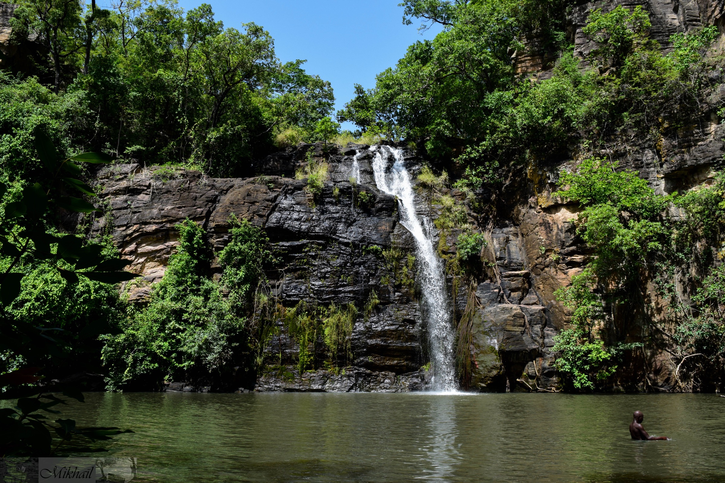
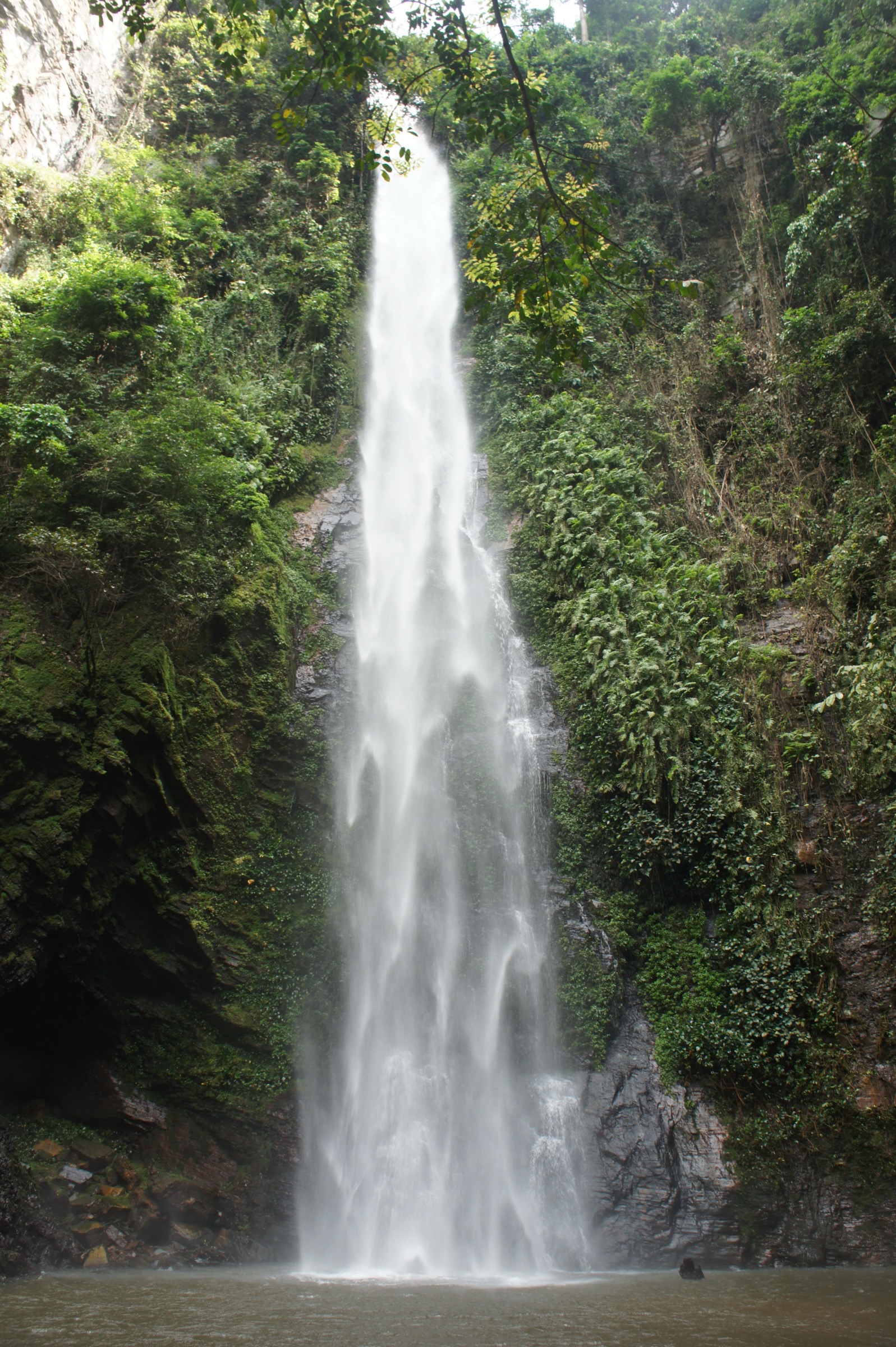
2. Wli Falls upper and lower walk
Snapshot
Itinerary
From the Wli reception, where a community fee is paid and a village guide assigned, the lower-falls path is a level forest walk of about 2.2 km along the Agumatsa River, crossing several footbridges and finishing at the plunge pool of the 80 m main drop. The upper-falls route branches above the lower amphitheatre and climbs steeply through forest on a switchbacked clay-and-rock tread; the short route is the steeper of the two and the long route loops with broader views before descending. The upper viewpoint looks across to the head of the falls. Thousands of fruit bats roost on the cliffs above the lower pool. Return to Wli reception by the inbound path or, on the long upper route, completes a loop.
Why it is essential
Wli is the tallest waterfall in Ghana and the tallest in West Africa, set inside the Agumatsa Wildlife Sanctuary at the foot of the same ridge that holds Mount Afadja. The combined lower-and-upper walk is the headline waterfall hike of the entire Akwapim-Togo Range.
Equipment
- Trail shoes with grip; the upper path is slippery when wet
- Sun protection on the lower approach
- Swimwear for the lower plunge pool
- 1-2 L water for the lower walk; 2-3 L for the upper hike
- Insect repellent
- Community fee paid at Wli reception; village guide required
Hazards and notes
- Steep, slippery tread on the upper route, especially in or after rain.
- Falling spray and slick rock at the plunge pool.
- Bat colony on the upper cliffs; spray and droppings near the pool.
- Hot, humid forest air; heat exhaustion possible on the upper route.
- Sanctuary entry fee and registered guide required.
GPX / KML links
| Source | URL | Format / access | Reuse status |
|---|---|---|---|
| Wikiloc search — Wli Falls | wikiloc.com | Search page; user tracks | Wikiloc terms apply on selection; reuse unresolved |
| OpenStreetMap — Wli waterfalls search | openstreetmap.org | Source map / search | OSM data is ODbL; geometry cross-check only |
External links
3. Mount Gemi and the Iron Cross from Amedzofe
Snapshot
Itinerary
Amedzofe sits at around 600 m, often described as Ghana’s highest habitable village, in the Avatime hills. From the village tourism office the path climbs a short, steady grassy and forested slope to the Iron Cross — a steel monument erected by the German Evangelical Missions Institute (GEMI) in 1939 to commemorate fifty years of missionary work. The summit gives long views east toward the Volta basin and south-east across the range. Most visitors combine the climb with the village canopy walkway and the short walk down to the local waterfall, making a half-day loop. Return is to the tourism office on the same path or via the canopy circuit.
Why it is essential
The Mount Gemi climb is the cultural-history summit of the range — a short, accessible viewpoint above Ghana’s highest village, with a missionary monument that ties the route to the colonial-era history of the Volta hills.
Equipment
- Trail shoes
- Sun hat and sun protection
- 1-2 L water
- Light rain layer in shoulder seasons
- Community fee paid at Amedzofe tourism office; village guide normally required
Hazards and notes
- Path can be slippery in or after rain.
- Steep drop-offs near the cross monument.
- Canopy walkway has weight and weather restrictions.
- Cooler and wetter than the lower valleys; a layer is useful.
- Community fee and registered guide normally required.
GPX / KML links
| Source | URL | Format / access | Reuse status |
|---|---|---|---|
| Wikiloc search — Mount Gemi / Amedzofe | wikiloc.com | Search page; user tracks | Wikiloc terms apply on selection; reuse unresolved |
| OpenStreetMap — Amedzofe search | openstreetmap.org | Source map / search | OSM data is ODbL; geometry cross-check only |
External links
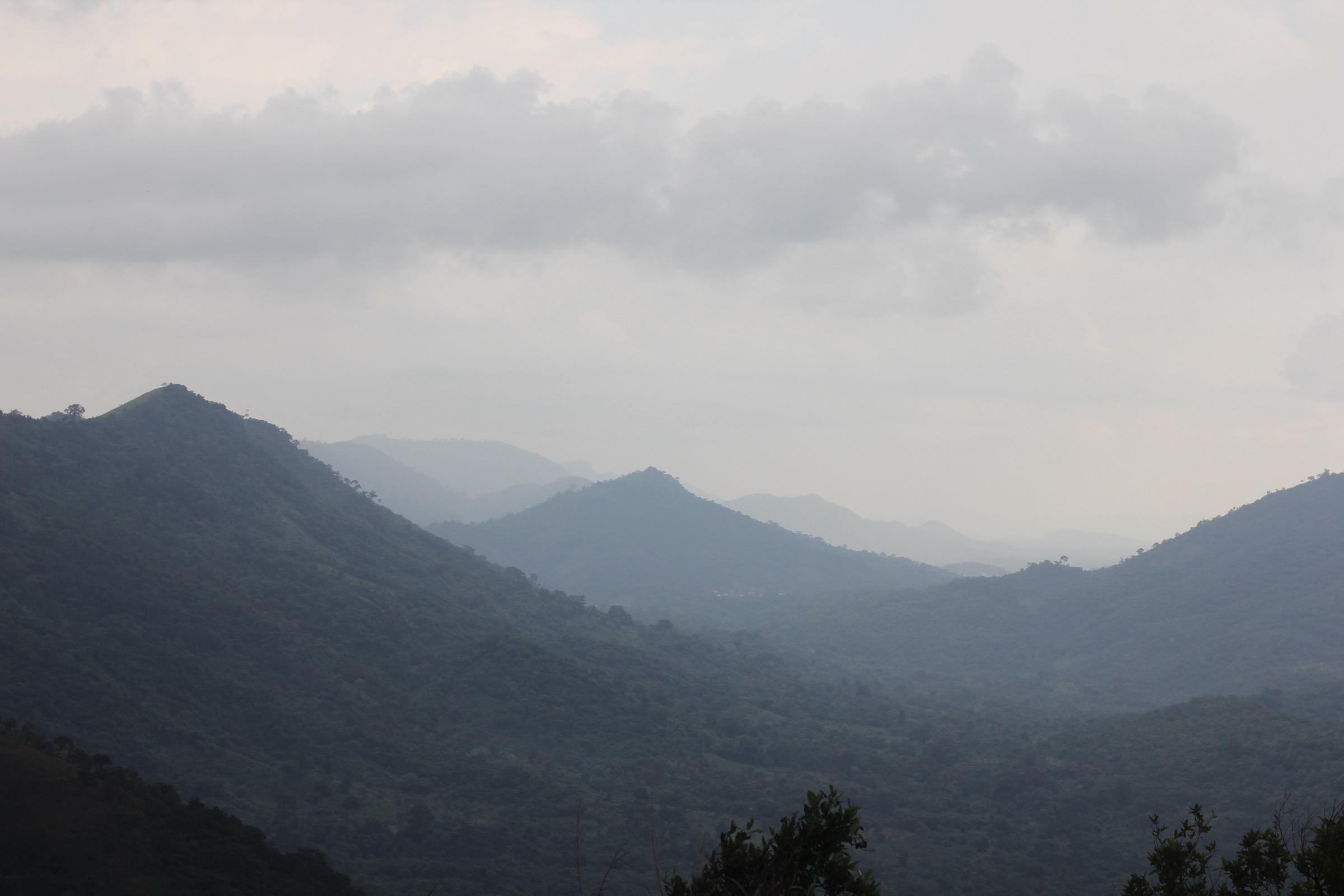
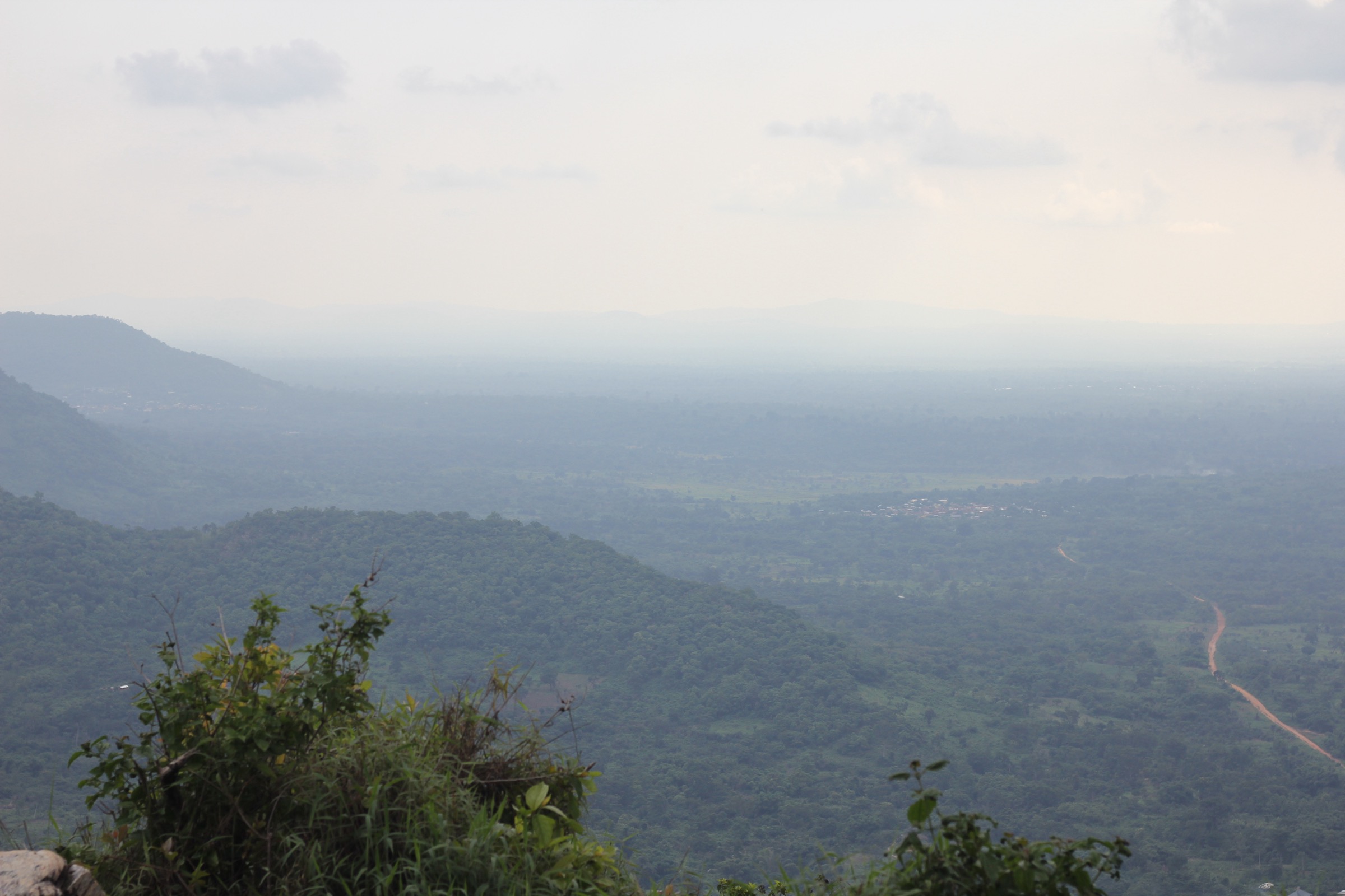
4. Mount Agou ascent above Kpalimé
Snapshot
Itinerary
Mount Agou — historically Pic d’Agou or Baumannspitze — rises south-east of Kpalimé as the high point of the Togo Mountains and the whole Akwapim-Togo Range. The foot ascent leaves a village trailhead on the lower flanks and climbs through cocoa, banana, and taro farms onto a steeper forested ridge. The path passes several inhabited hamlets between roughly 700 m and the summit; the route effectively links the village zone with the mountain’s farmed and forested upper slopes. The summit at 986 m carries a telecommunications mast and a French colonial-era marker; views in clear weather reach across the border into Ghana. A rough road climbs much of the way and can shorten the walk to a couple of hours, but the full village-to-summit ascent is the more typical “essential” hike.
Why it is essential
Mount Agou is Togo’s highest peak and the only summit on the range above 900 m on the Togolese side. The ascent is the headline Togo hike of the Akwapim-Togo chain and gives a long view back across to the Ghanaian Volta side.
Equipment
- Sturdy trail shoes or light boots
- Sun protection
- 2-3 L water per person; resupply possible at upper villages but not assured
- Light rain layer
- Local guide arranged in Kpalimé or at the trailhead village
Hazards and notes
- Long climb in humid forest; pace carefully.
- Tread is muddy in or after rain, especially on the upper forest section.
- Limited signage; a local guide is normally required.
- Telecommunications site at the summit — respect any access restrictions.
- Border zone in places; carry passport.
GPX / KML links
| Source | URL | Format / access | Reuse status |
|---|---|---|---|
| AllTrails — Mount Agou | alltrails.com | Route reference; GPX behind account | GPX reuse unresolved |
| Wikiloc search — Mont Agou | wikiloc.com | Search page; user tracks | Wikiloc terms apply on selection; reuse unresolved |
| OpenStreetMap — Mont Agou search | openstreetmap.org | Source map / search | OSM data is ODbL; geometry cross-check only |
External links
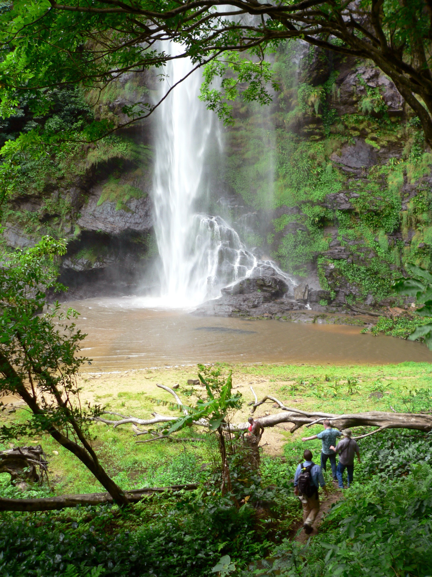
5. Tagbo Falls from Liati Wote
Snapshot
Itinerary
The Tagbo Falls walk leaves the Liati Wote ecotourism office on the same valley floor as the Mount Afadja start. The path heads up the Tagbo stream, crossing several small bridges and climbing gradually through cocoa and coffee farms into semi-deciduous forest. The final approach traces the river through a shaded amphitheatre to a multi-tier waterfall, with the longest individual drop around 60 m. A plunge pool below the falls is the usual rest point. The hike is well known for its butterfly diversity — local sources report more than 300 species in the wider Liati Wote area. Return is on the same path.
Why it is essential
Tagbo Falls is the natural companion to Mount Afadja: short enough to combine with the summit on a single visit to Liati Wote, scenic on its own, and an important biodiversity site for the Volta Region.
Equipment
- Trail shoes
- Sun protection on the open farm sections
- Swimwear for the plunge pool
- 1-2 L water
- Insect repellent
- Community fee paid at Liati Wote; village guide required
Hazards and notes
- Slippery river crossings in or after rain.
- Slick rock at the plunge pool.
- Heat and humidity on the lower farm section.
- Snakes in the forest understorey.
- Community fee and registered guide required.
GPX / KML links
| Source | URL | Format / access | Reuse status |
|---|---|---|---|
| Wikiloc search — Tagbo Falls | wikiloc.com | Search page; user tracks | Wikiloc terms apply on selection; reuse unresolved |
| OpenStreetMap — Tagbo Falls search | openstreetmap.org | Source map / search | OSM data is ODbL; geometry cross-check only |
External links
Missing data / follow-up work
- No officially published GPX/KML downloads were located for any of the five routes; Wikiloc, AllTrails, and OpenStreetMap are used as geometry references only.
- Distance and ascent figures for Mount Afadja, Wli Upper Falls, and Mount Agou vary noticeably between sources and operators; the figures above are best-available approximations and route-specific GPS tracks are needed to firm them up.
- Mount Gemi summit elevation reports range from roughly 611 m to 777 m across sources; 614 m is the commonly cited Iron Cross figure but requires authoritative survey confirmation.
- Community-fee schedules at Liati Wote, Wli, and Amedzofe change frequently; confirm current rates and guide arrangements at the village ecotourism offices before travel.
- Public transport from Accra to the Volta hill villages requires tro-tro plus taxi or moto-taxi connections; precise timetables are not published.
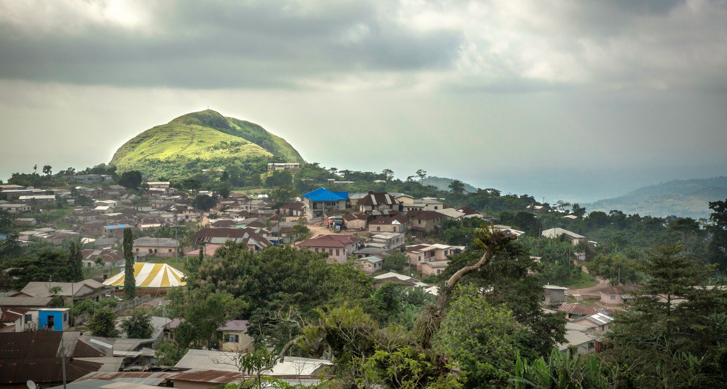
- A licence-compatible photograph dedicated to Mount Agou itself at the required resolution was not located in this pass; the Kpalimé range view is used as a regionally representative substitute and a higher-resolution direct Mount Agou image is still pending.