Regional overview
The Jura Mountains form a lower, limestone mountain arc along the French–Swiss border, with high rounded ridges, forested valleys, karst features, waterfalls, lakes, pasture summits and cliff viewpoints. This selection focuses on the western and central Jura: the Haute Chaîne / Monts Jura, Haut-Doubs, the Jura lake-and-waterfall country, and the Neuchâtel–Vaud Jura.
The hiking is usually non-alpine in summer, but the terrain should not be underestimated. Routes can involve long ridge distances, fog-prone plateaux, steep limestone drops, slippery waterfall paths, exposed cliff rims and winter snow.
Main access centres include Lélex, Métabief / Les Longevilles-Mont-d’Or, Menétrux-en-Joux / the Hérisson valley, Noiraigue and Les Rasses. Lift timetables, winter closures, snowshoe variants and local protected-area rules need checking close to departure.
Selection rationale
The five hikes were selected to represent the main Jura hiking types: the highest French Jura ridge, a classic Haut-Doubs balcony crest, the best-known waterfall walk in the French Jura, the iconic Swiss limestone cirque of Creux du Van, and a Vaud Jura summit with broad Alpine views.
Summary table
| # | Hike | Country | Route type | Distance | Gain | Max elevation | Difficulty | Photos |
|---|---|---|---|---|---|---|---|---|
| 1 | Crêt de la Neige and Le Reculet from Lélex | France | Out-and-back with ridge traverse extension | Not verified | Not fully verified; summit c. 1,720 m | c. 1,720 m | Moderate–hard | Open Commons candidates found |
| 2 | Morond and Mont d’Or ridge loop | France | Loop; optional lift-assisted access | 7.9 km | 307 m | 1,463 m | Intermediate | Open Commons candidate found |
| 3 | Cascades du Hérisson classic route | France | Out-and-back | 7.0–7.5 km; official 7.4 km | 250–295 m | 735 m | Medium | Open Commons candidates found |
| 4 | Creux du Van from Noiraigue | Switzerland | Loop | 13.5–14.3 km | 770–858 m | c. 1,464 m | Difficult | Open Commons candidate found |
| 5 | Le Chasseron from Les Rasses | Switzerland | Loop | 7.83 km; 11–11.6 km on longer variants | 498 m; 471–520 m on longer variants | 1,605 m; summit c. 1,607 m | T1 / easy on shorter route; longer variants more demanding | Open Commons candidate found |
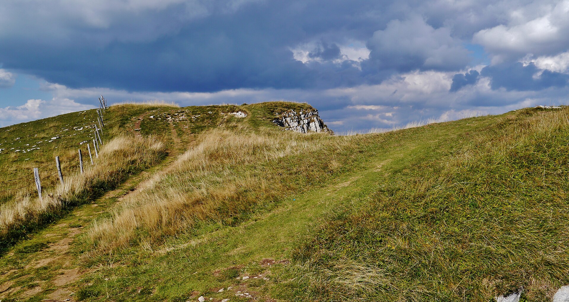
1. Crêt de la Neige and Le Reculet from Lélex
Snapshot
Itinerary
From Lélex, the route climbs the GR 9 towards Refuge de la Loge, or traverses from the top of the gondola towards the same refuge. Above the refuge, the path gains the GR Balcon du Léman, crosses towards the Grand Crêt area, then follows the ridge towards Crêt de la Neige. The continuation south-west follows the ridge and combes to Le Reculet, whose open summit and metal cross give wider views than the wooded high point of Crêt de la Neige. The return follows the same general ridge and descent line.
Why it is essential
This is the high-point hike of the French Jura and the clearest way to experience the broad, grassy, wooded and karstic crest of the Haute Chaîne. It links the massif’s highest summit area with Le Reculet, one of the most recognisable nearby summits.
Equipment
- Sturdy boots
- Weatherproof layer
- Warm layer
- Water and food
- Map/GPS
- Navigation backup
- Sun protection
- Trekking poles recommended
- Snowshoes and winter navigation equipment in winter conditions
Hazards and notes
- Fog is the main navigation hazard on the broad ridge.
- Snow can persist or return early.
- The high ridge lies in or near protected Haut-Jura areas; local reserve rules, dog restrictions and seasonal wildlife-protection restrictions need checking before travel.
GPX / KML links
| Source | URL | Format | Notes |
|---|---|---|---|
| Altituderando route page / map | altituderando.com | Source map / route description | Usable as source reference only; no GPX/KML download verified |
Sources
- Altituderando — Le Crêt de la Neige et Le Reculet par Lélex
- Wikimedia Commons — ReculetDepuisCretDeLaNeige
2. Morond and Mont d’Or ridge loop
Snapshot
Itinerary
The official Explore Doubs Rando route follows the Morond and Mont d’Or crest, using a PR loop above the high Doubs valley. The ridge crosses a sequence of open viewpoints, reaches the Belvédère du Chamois and continues to Mont d’Or, whose summit area gives views towards the Swiss plain, Lake Neuchâtel, Lake Geneva and the Alps in clear weather. The route can be approached from Métabief using the Morond chairlift or from the Mont d’Or car park.
Why it is essential
Mont d’Or is one of the defining balcony summits of the French Jura. The route is short enough for a half-day but gives a concentrated sample of Haut-Doubs ridge walking, pastoral landscapes and long cross-border views.
Equipment
- Hiking shoes or boots
- Weatherproof layer
- Warm layer
- Water and food
- Map/GPS
- Sun protection
- Trekking poles useful on steep or wet grassy sections
Hazards and notes
- Weather exposure on the open crest.
- Fog possible.
- Steep drops near viewpoints.
- Lift schedules and access from Métabief need checking if using the lift-assisted variant.
GPX / KML links
| Source | URL | Format | Notes |
|---|---|---|---|
| Explore Doubs Rando | explore-admin.doubs.fr | GPX | Official download link exposed by route page; reuse terms unresolved |
| Explore Doubs Rando | explore-admin.doubs.fr | KML | Official download link exposed by route page; reuse terms unresolved |
| Explore Doubs Rando route page | explore.doubs.fr | Source page | Use as official source reference |
Sources
- Explore Doubs Rando — Autour du Morond et du Mont d’Or par les Crêtes
- Wikimedia Commons — Doubs Mont-d’Or 01
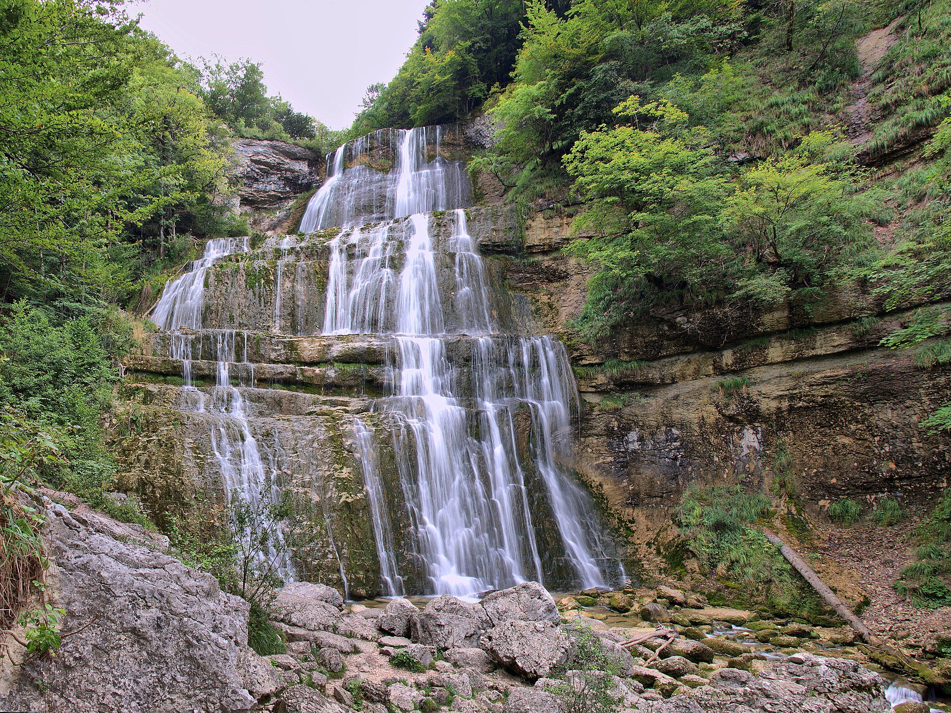
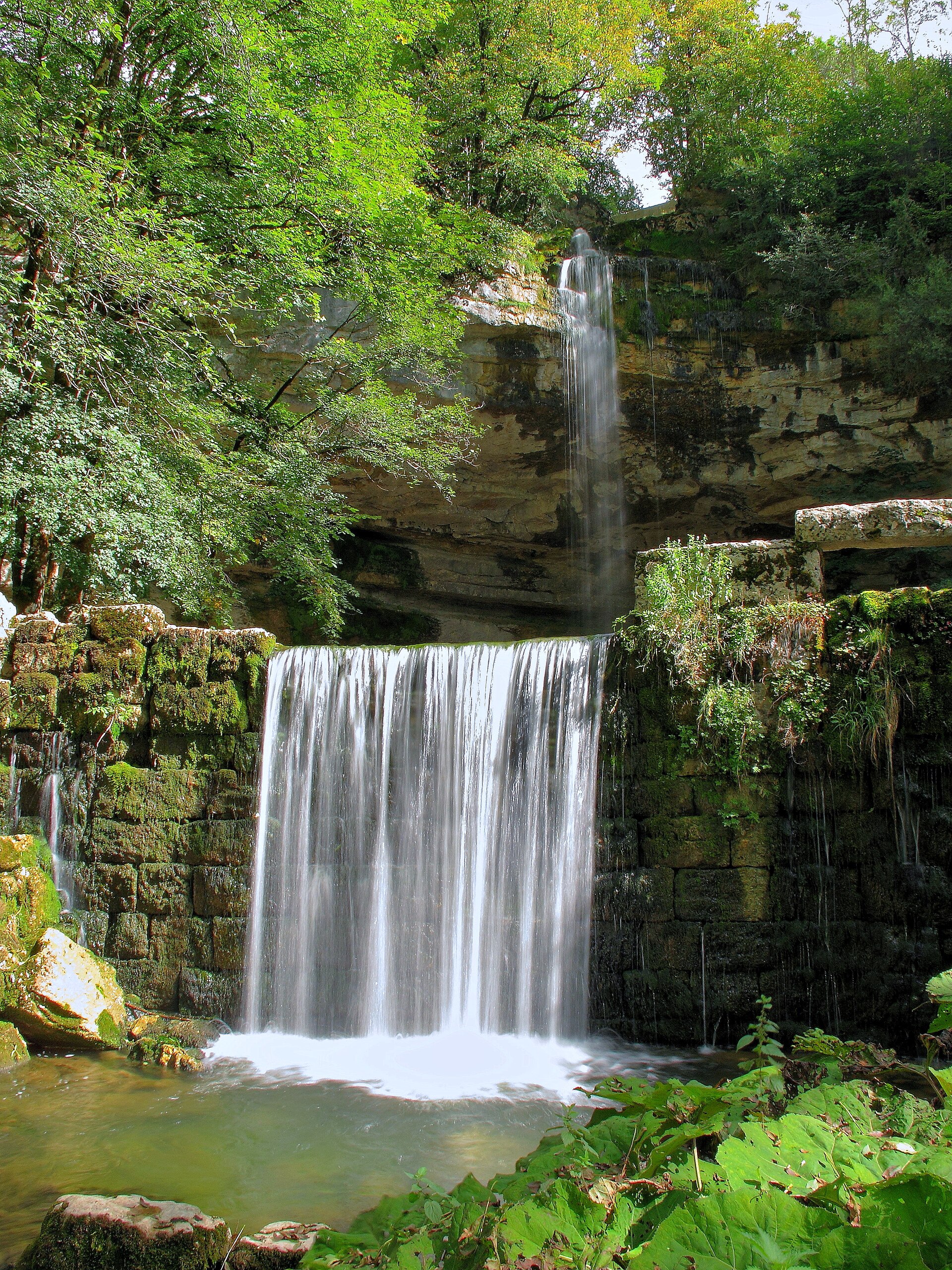
3. Cascades du Hérisson classic route
Snapshot
Itinerary
From the Maison des Cascades, the path follows the Hérisson river upstream through the classic seven-waterfall sequence. The official site describes a 7.4 km out-and-back walk of about 3 h, while Terre d’Émeraude Tourisme describes the 3.7 km one-way sequence as 7.4 km return with about 250 m of ascent. The named waterfalls include L’Éventail, Grand Saut, Gour Bleu, Château Garnier, Saut de la Forge, Moulin Jeunet and Saut Girard.
Why it is essential
This is the classic waterfall hike of the French Jura. It represents the region’s karst watercourses, wooded gorges and tourist heritage, and is one of the most recognisable low-mountain walks in the massif.
Equipment
- Grippy hiking shoes or boots
- Weatherproof layer
- Water and food
- Map/GPS
- Tick protection
- Child carrier rather than pushchair for young children on the full route
Hazards and notes
- The path can be slippery.
- The route has meaningful height gain despite its modest distance.
- Stay on marked paths.
- Dogs must be kept on a lead.
- Pedestrian-only access.
- Camping, bathing, fires and overnight campervan parking are prohibited.
- Parking is charged during the stated 2025 season from 5 April to 30 September.
GPX / KML links
| Source | URL | Format | Notes |
|---|---|---|---|
| Cirkwi / Terre d’Émeraude Tourisme route | cirkwi.com | Source route page | Source route verified; reuse terms unresolved |
| Cirkwi GPX export | cirkwi.com | GPX | GPX download link found; reuse terms unresolved |
Sources
- Official Cascades du Hérisson route page
- Terre d’Émeraude Tourisme — Cascades du Hérisson
- Cirkwi — Les Cascades du Hérisson, la rando classique
- Wikimedia Commons — Cascades du Hérisson, l’Éventail
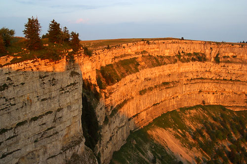
4. Creux du Van from Noiraigue
Snapshot
Itinerary
From Noiraigue, the route climbs the well-known “quatorze contours” path, the steepest and most sustained part of the walk, to gain the rim of Creux du Van. The path then follows the summit area above the horseshoe limestone amphitheatre before descending by the Sentier du Single back towards Noiraigue.
Why it is essential
Creux du Van is the emblematic Swiss Jura cirque: a broad, cliff-rimmed limestone amphitheatre, widely recognised as one of the Jura’s landmark viewpoints. It adds a more dramatic cliff-and-cirque landscape to the regional selection.
Equipment
- Sturdy boots
- Trekking poles recommended
- Weatherproof layer
- Warm layer
- Water and food
- Map/GPS
- Navigation backup
- Sun protection
- Microspikes may be needed in early or late season if snow or ice remains
Hazards and notes
- The cliff rim is exposed.
- Wind, fog, snow or ice increase seriousness significantly.
- Dogs are strongly discouraged near the Creux du Van / Le Soliat pastures because of suckler cows and safety concerns.
- Rail timetables to Noiraigue need checking before travel.
GPX / KML links
| Source | URL | Format | Notes |
|---|---|---|---|
| Neuchâtel Rando | neuchatelrando.ch | Source route page | Route/stat source only; no GPX found |
| Jura & Trois-Lacs | j3l.ch | Source route page / map | Source route verified; no GPX download verified |
| AllTrails secondary variant | alltrails.com | Source route page | Secondary verification only; reuse not assessed |
Sources
- Neuchâtel Rando — Le Creux du Van
- Jura & Trois-Lacs — Creux du Van
- AllTrails — Creux du Van via Noiraigue
- Wikimedia Commons — Creux du Van
5. Le Chasseron from Les Rasses
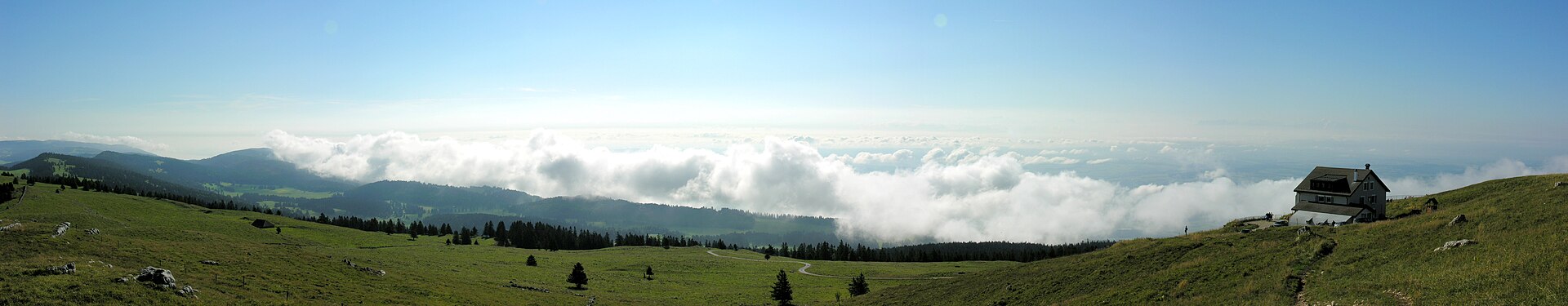
Snapshot
Itinerary
From Les Rasses, the shorter loop climbs to Le Chasseron, then returns via Les Avattes to Les Rasses. The broader Chasseron route describes an initial walk along the forest edge and an ascent of about 400 m through forest towards the Chasseron crests, followed by a return through woods and pastures towards Les Rasses.
Why it is essential
Le Chasseron is one of the representative summits of the Vaud Jura. It gives a compact summit walk above Sainte-Croix / Les Rasses and balances the selection with a Swiss pasture-and-crest hike rather than another gorge or waterfall route.
Equipment
- Hiking shoes or boots
- Weatherproof layer
- Warm layer
- Water and food
- Map/GPS
- Sun protection
- Trekking poles recommended for longer variants
Hazards and notes
- The route is generally non-technical in summer.
- Fog, wind and snow can affect the open crest.
- Winter itineraries should be treated separately as snowshoe routes, not as the same summer hike.
GPX / KML links
| Source | URL | Format | Notes |
|---|---|---|---|
| Vaud Rando / balades.ch | balades.ch | Source route page with SuisseMobile trace link | Route/stat source only; no GPX download verified |
| MySwitzerland / SchweizMobil data route | myswitzerland.com | Source route page | SwitzerlandMobility data source noted; no GPX download verified |
| Outdooractive | outdooractive.com | Source route page | Secondary route source only; reuse not assessed |
Sources
- Vaud Rando / balades.ch — Le Chasseron depuis Les Rasses
- MySwitzerland — Parcours du Chasseron
- Outdooractive — Le Chasseron route
- Wikimedia Commons — Le Chasseron
Region-level sources
| Source | Use | URL |
|---|---|---|
| Altituderando — Crêt de la Neige and Le Reculet | French Jura high point | altituderando.com |
| Explore Doubs Rando — Morond and Mont d’Or | Haut-Doubs balcony summit | explore.doubs.fr |
| Cascades du Hérisson official route page | Waterfall walk | cascades-du-herisson.fr |
| Terre d’Émeraude Tourisme — Cascades du Hérisson | Waterfall walk | terredemeraudetourisme.com |
| Cirkwi — Cascades du Hérisson GPX source | Waterfall walk GPX | cirkwi.com |
| Neuchâtel Rando — Creux du Van | Swiss Jura cirque | neuchatelrando.ch |
| Jura & Trois-Lacs — Creux du Van | Swiss Jura cirque | j3l.ch |
| Vaud Rando / balades.ch — Le Chasseron | Vaud Jura summit | balades.ch |
| MySwitzerland — Parcours du Chasseron | Vaud Jura summit | myswitzerland.com |