Regional overview
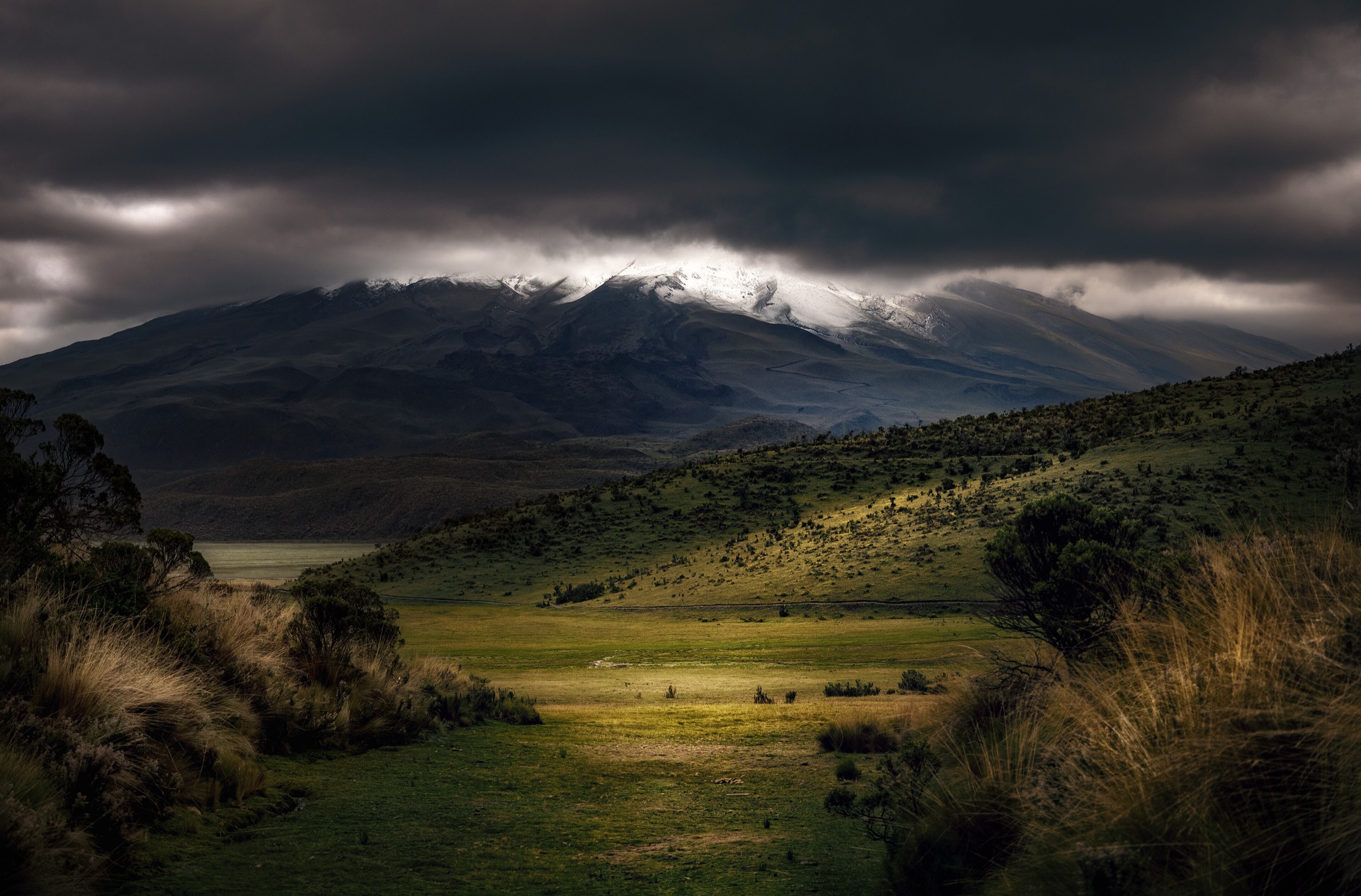
Chimborazo and the central Ecuadorian Andes are defined by high volcanic paramo, glaciated summits, dry volcanic sand slopes, vicuna habitat, indigenous communities and crater-lake landscapes. The main walking centres are Riobamba, Guaranda, Alausi, Latacunga and Quilotoa, with Chimborazo Fauna Production Reserve and nearby Sangay / Illinizas protected-area sectors providing the strongest day-hiking objectives.
The hiking character is high-altitude and weather-sensitive. Several routes begin above 3,800 m and some touch or exceed 5,000 m without becoming technical mountaineering routes. Short distances can still feel severe because of altitude, wind, cold, sand, poor visibility and rapid weather changes.
The practical dry-season window is often June-September and December-February, but Ecuadorian highland weather is variable year-round. Chimborazo and Carihuairazo routes require careful acclimatisation; upper slopes may require local guidance or mountaineering judgement if snow, ice or storm conditions are present.
Selection rationale
The selection balances the central Andes’ defining experiences: a very high non-technical Chimborazo refuge walk, the culturally important Templo Machay traverse, the Carihuairazo volcanic high trail, the famous Quilotoa crater rim and the Ozogoche lake landscape in the Chimborazo / Sangay highlands. Technical glacier ascents of Chimborazo and El Altar are excluded.
Summary table
| # | Hike | Country | Route type | Distance | Gain | Max elevation | Difficulty |
|---|---|---|---|---|---|---|---|
| 1 | Refugio Carrel - Refugio Whymper - Laguna Condor Cocha | Ecuador | Out-and-back | 2.4 km | 244 m | approx. 5,100 m | Hard by altitude |
| 2 | Templo Machay Traverse from Refugio Carrel | Ecuador | Point-to-point / traverse | 8.4 km | approx. 400-800 m depending variant | approx. 4,845 m | Hard |
| 3 | Carihuairazo High Trail / Summit Approach | Ecuador | Out-and-back | 15.5 km | 800 m | 5,020 m if summiting | Hard |
| 4 | Quilotoa Crater Rim Circuit | Ecuador | Loop | 10.8 km | 795 m | approx. 3,915 m | Hard |
| 5 | Lagunas de Ozogoche Shoreline and Viewpoints | Ecuador | Out-and-back / flexible lake walk | 2.7 km minimum | 52 m | approx. 3,800 m | Easy-moderate by altitude |
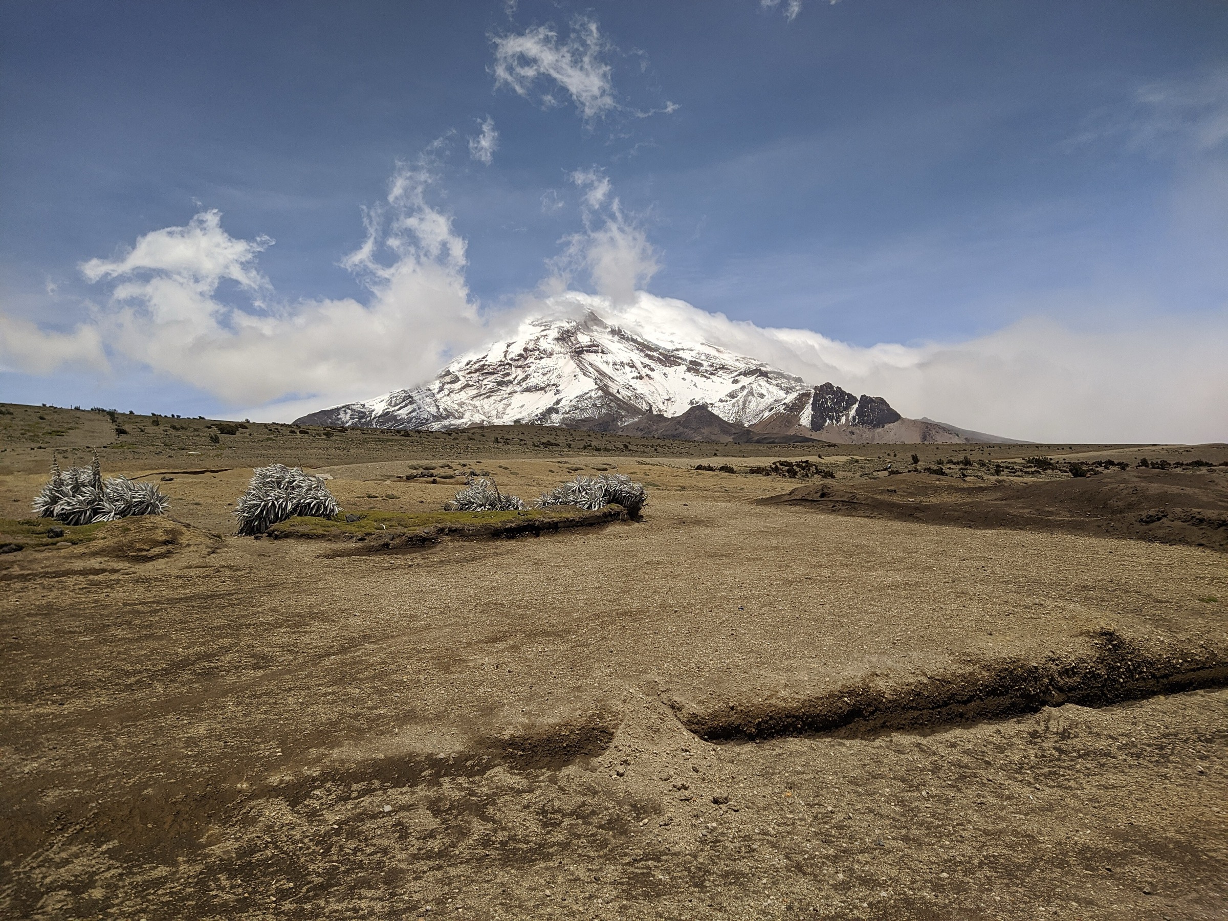
1. Refugio Carrel - Refugio Whymper - Laguna Condor Cocha
Snapshot
Itinerary
The route starts at Refugio Hermanos Carrel and climbs the marked high-altitude path to Refugio Whymper. Ecuador Travel lists Carrel at 4,850 m and Whymper at 5,050 m, with about 1 km of walking between them. The route can be continued a short distance to Laguna Condor Cocha, a small high lake below Chimborazo’s upper slopes, before returning by the same path.
This is not a summit route and should not be confused with the glacier ascent of Chimborazo. The walk is short but takes place at extreme altitude for most visitors.
Why it is essential
This is the classic non-technical way to experience Chimborazo’s high volcanic environment. It gives access to the mountain’s refuge zone, glacier views, volcanic sand and the symbolic 5,000 m level without requiring ropes or a summit attempt.
Equipment
- Sturdy footwear
- Warm layer
- Waterproof/windproof shell
- Hat and gloves
- Sun protection
- Water and snacks
- Map/GPS
- Microspikes if the path is icy
Hazards and notes
- Altitude sickness is the main hazard.
- Wind, cold, low visibility, snow and ice can make the route serious.
- Do not continue onto glacier terrain without mountaineering equipment, guide judgement and current conditions.
- Register at the reserve control point where required.
GPX / KML links
| Source | URL | Format / access | Reuse status |
|---|---|---|---|
| AllTrails: Carrel Refuge - Condor Cocha Lagoon | alltrails.com | Source map; AllTrails terms apply | No direct GPX retrieved; source-map reference only |
| OpenStreetMap search: Laguna Condor Cocha Chimborazo | openstreetmap.org | Map geometry cross-check; ODbL | Geometry cross-check only |
External links
- Ecuador Travel — Riobamba / Chimborazo access and refuge elevations
- MAATE / Ambiente — Areas Protegidas Sierra 2 (Chimborazo visitor sites and hours)
- AllTrails — Carrel Refuge - Condor Cocha Lagoon
2. Templo Machay Traverse from Refugio Carrel
Snapshot
Itinerary
From Refugio Carrel, the traverse crosses the south-western flank of Chimborazo through volcanic sand, paramo, rock outcrops, wetlands and small streams. The route visits Templo Machay, a sacred volcanic cave on the flank of the Whymper summit, then continues toward the Chorrera Mirador / Pulinguí community sector.
The Riobamba municipal tourism page gives the route as 8.4 km, about 6 hours, with low technical difficulty but a local guide recommended because of weather and route conditions. Wikiloc variants differ substantially depending on whether walkers start lower, include the refuges, or make a loop.
Why it is essential
Templo Machay is the central cultural day hike of the Chimborazo area, linking the high mountain with Puruhá / Andean sacred geography, community access and the traditional walking terrain below the volcano.
Equipment
- Boots
- Waterproof/windproof shell
- Warm layer
- Hat and gloves
- Sun protection
- Water and food
- GPS/offline map
- Compass backup
- Headtorch
- Trekking poles for volcanic sand
Hazards and notes
- Navigation can be difficult in cloud.
- The route is exposed to wind, cold, hail and poor visibility.
- Mobile coverage may be absent.
- The municipal page recommends a local guide.
- Register at El Arenal / reserve control where required and confirm the legal start/finish and transport before departure.
GPX / KML links
| Source | URL | Format / access | Reuse status |
|---|---|---|---|
| GADM Riobamba / GoRaymi: Templo Machay route map | riobamba.com.ec | Source page with downloadable route map; terms not clearly stated | Official/municipal route reference; map reuse unresolved |
| Wikiloc: Templo Machay Chimborazo Riobamba | wikiloc.com | Source map / downloadable route via Wikiloc | Wikiloc terms apply; source-map reference only |
External links
- GADM Riobamba / GoRaymi — Ruta de senderismo Templo Machay
- MAATE / Ambiente — Areas Protegidas Sierra 2
- Wikiloc — Templo Machay Chimborazo Riobamba
3. Carihuairazo High Trail / Summit Approach
Snapshot
Itinerary
The route approaches Carihuairazo from the Chimborazo reserve side, crossing open paramo and volcanic high ground toward the mountain’s upper slopes. AllTrails records the summit route as 15.5 km out-and-back with about 800 m of ascent. Ecuador Travel identifies Carihuairazo as a trekking and mountaineering objective from the Mechahuasca sector inside the reserve.
The exact safe turnaround should be chosen according to current conditions. If snow, ice, unstable rock or poor visibility is present, the route should be treated as a guided mountaineering objective rather than a normal day hike.
Why it is essential
Carihuairazo is Chimborazo’s neighbouring high volcano and gives a quieter, wilder view of the same reserve landscape: vicuna paramo, volcanic ridges and close perspectives on Chimborazo itself.
Equipment
- Mountain hiking equipment
- Navigation backup
- Headtorch
- Extra insulation
- Helmet, microspikes or crampons if the upper route is icy or unstable
- Qualified guide if conditions are not dry and straightforward
Hazards and notes
- Altitude, route-finding, wind, cold and changing snow/ice conditions are serious hazards.
- The upper summit area may exceed the non-technical day-hike threshold in poor conditions.
- Local advice from the reserve/community sector should be checked before departure.
GPX / KML links
| Source | URL | Format / access | Reuse status |
|---|---|---|---|
| AllTrails: Carihuairazo Summit | alltrails.com | Source map; AllTrails terms apply | No direct GPX retrieved; source-map reference only |
| OpenStreetMap search: Carihuairazo | openstreetmap.org | Map geometry cross-check; ODbL | Geometry cross-check only |
External links
- Ecuador Travel — Riobamba / Chimborazo and Carihuairazo mention
- MAATE / Ambiente — Areas Protegidas Sierra 2
- AllTrails — Carihuairazo Summit
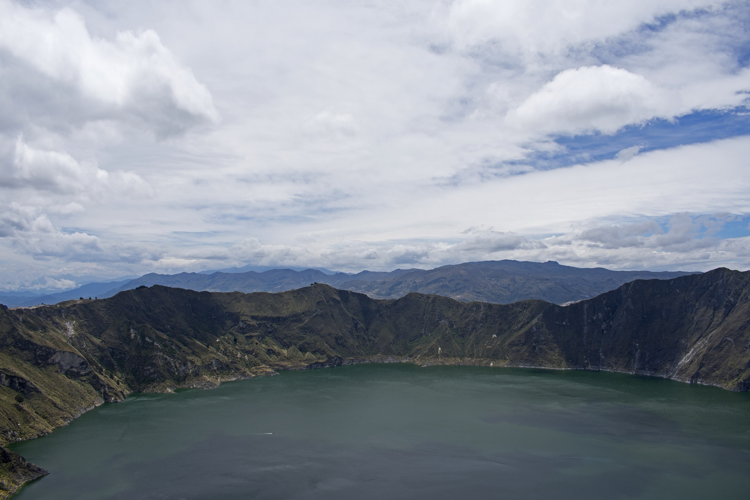
4. Quilotoa Crater Rim Circuit
Snapshot
Itinerary
The circuit follows the rim of Laguna Quilotoa, a high volcanic crater lake west of Latacunga. From Quilotoa village, the path climbs and descends repeatedly around the crater edge, giving changing views into the turquoise lake and across the central Andes. Sandy, eroded and exposed sections make the loop more demanding than the distance suggests.
AllTrails records the crater circuit as 10.8 km with 795 m of ascent. The route can be shortened by walking only to nearby viewpoints, but the full rim circuit is the essential day-hike version.
Why it is essential
Quilotoa is one of Ecuador’s most recognisable highland landscapes. The rim walk gives a complete volcanic-crater experience and a strong contrast to the glacier-volcano terrain of Chimborazo.
Equipment
- Sturdy shoes
- Windproof layer
- Warm layer
- Water and food
- Sun protection
- Map/GPS
- Trekking poles for loose descents
Hazards and notes
- The rim is exposed to wind, lightning, fog and eroded edges.
- Several side paths descend steeply toward the lake; climbing back to the rim is strenuous at altitude.
- Confirm local access fees, community rules and transport times before walking.
GPX / KML links
| Source | URL | Format / access | Reuse status |
|---|---|---|---|
| AllTrails: Quilotoa Crater Circuit | alltrails.com | Source map; AllTrails terms apply | Source-map reference only |
| OpenStreetMap search: Quilotoa crater rim | openstreetmap.org | Map geometry cross-check; ODbL | Geometry cross-check only |
External links
5. Lagunas de Ozogoche Shoreline and Viewpoints
Snapshot
Itinerary
The walk follows the shore and nearby viewpoints of the Ozogoche lake system, a group of high paramo lakes within the Sangay National Park landscape. Short mapped routes stay close to the main lake access area, while local/community variants can be extended between multiple lagoons.
The AllTrails source route gives a short 2.7 km out-and-back with little ascent. Regional sources describe Ozogoche as a larger lake complex, so any extended version should be planned locally rather than inferred from the short source map.
Why it is essential
Ozogoche represents the central Ecuadorian highland lake systems rather than the volcanic summit walks. It adds Sangay National Park’s paramo, wetland and bird-cultural landscape to the Chimborazo-centred selection.
Equipment
- Standard hiking equipment
- Warm/waterproof layers
- Sun protection
- Water and food
- Offline map
- Waterproof footwear
Hazards and notes
- Weather can change quickly, and fog can make lake-country navigation confusing.
- Stay on established paths, respect community access and protected-area rules, and avoid disturbing birdlife or wetlands.
- Route statistics beyond the short AllTrails line remain unresolved.
GPX / KML links
| Source | URL | Format / access | Reuse status |
|---|---|---|---|
| AllTrails: Lagunas de Ozogoche | alltrails.com | Source map; AllTrails terms apply | Source-map reference only |
| OpenStreetMap search: Lagunas de Ozogoche | openstreetmap.org | Map geometry cross-check; ODbL | Geometry cross-check only |
External links
- MAATE / Ambiente — Areas Protegidas Sierra 3 (Sangay visitor sites)
- Riobamba.com.ec — Ozogoche Lagoons
- AllTrails — Lagunas de Ozogoche
External links
| Source | URL |
|---|---|
| Ecuador Travel — Riobamba / Chimborazo | ecuador.travel |
| Ecuador Travel — Andes page | ecuador.travel |
| MAATE / Ambiente — Areas Protegidas Sierra 2 | ambiente.gob.ec |
| MAATE / Ambiente — Areas Protegidas Sierra 3 | ambiente.gob.ec |
| GADM Riobamba / GoRaymi — Templo Machay route | riobamba.com.ec |
| Riobamba.com.ec — Ozogoche Lagoons | riobamba.com.ec |
| AllTrails — Carrel Refuge - Condor Cocha Lagoon | alltrails.com |
| AllTrails — Carihuairazo Summit | alltrails.com |
| AllTrails — Quilotoa Crater Circuit | alltrails.com |
| AllTrails — Lagunas de Ozogoche | alltrails.com |
| Wikiloc — Templo Machay Chimborazo Riobamba | wikiloc.com |