
Regional overview
Mohéli, or Mwali, is the smallest of the main Comoros islands. Its walking character is lower and more coastal than Grande Comore or Anjouan, but the interior still has rugged ridges, stream valleys, and remnant forest around Mount Mlédjélé / Mzé Koukoulé. Mohéli National Park includes marine, coastal, and terrestrial areas; the park is recorded at 643.62 km² and was expanded in 2015 to include much of the island’s land area.
Published day-hike data is very sparse. The strongest source-backed natural objectives are the Mwali highlands around Mount Mlédjélé, the Lake Dziani Boundouni Ramsar crater lake, and the Nioumachoua / Ouallah sectors of Mohéli National Park. None had a verified public GPX or measured hiking route in this pass.
This entry therefore treats all five hikes as candidate-only. The selections are still useful research targets because they represent the island’s high ridge, crater lake, coastal-park viewpoints, ridge-to-coast forest edges, and north-slope access, but they should not be presented as finished guidebook routes.
Selection rationale
The five candidates were selected to cover the main documented Mohéli highland and park landscapes: Mount Mlédjélé, Lake Dziani Boundouni, Nioumachoua, Ouallah, and the Fomboni/Djoièzi north-slope approaches. Route statistics remain unresolved unless a future source provides mapped geometry.
Summary table
| # | Hike | Country | Route type | Distance | Gain | Max elevation | Difficulty |
|---|---|---|---|---|---|---|---|
| 1 | Mount Mlédjélé / Mzé Koukoulé highland ridge | Comoros | Unresolved | Unresolved | Unresolved | 790 m | Candidate only |
| 2 | Lake Dziani Boundouni crater-lake access walk | Comoros | Unresolved | Unresolved | Unresolved | Unresolved | Candidate only |
| 3 | Nioumachoua marine-park viewpoint walk | Comoros | Unresolved | Unresolved | Unresolved | Unresolved | Candidate only |
| 4 | Ouallah ridge-to-coast forest edge | Comoros | Unresolved | Unresolved | Unresolved | Unresolved | Candidate only |
| 5 | Fomboni / Djoièzi north-slope highland candidate | Comoros | Unresolved | Unresolved | Unresolved | Unresolved | Candidate only |
1. Mount Mlédjélé / Mzé Koukoulé highland ridge

Snapshot
Itinerary
The candidate objective is the highland ridge around Mount Mlédjélé / Mzé Koukoulé, the highest documented Mohéli upland. A public hiking line, trailhead, route length, and access conditions were not verified in this pass.
Why it is essential
The Mlédjélé highlands are the core terrestrial mountain feature of Mohéli and are associated with remaining forest and endemic wildlife. A verified route here would be the natural highland anchor for the island.
Equipment
Standard to mountain hiking equipment: boots, rain layer, water, food, sun protection, and navigation backup.
Hazards and notes
Trail access, forest condition, water, local permissions, and park rules are unresolved. This should remain candidate-only until a local or official route source is identified.
GPX / KML links
| Source | URL | Format / access | Reuse status |
|---|---|---|---|
| OpenStreetMap search — Mount Mlédjélé | openstreetmap.org | Map data / search | OSM data is ODbL; candidate geometry cross-check only |
| Wikimedia Commons search — Mount Mlédjélé | commons.wikimedia.org | Image search | Search target recorded; no reusable highland image verified |
External links
2. Lake Dziani Boundouni crater-lake access walk

Snapshot
Itinerary
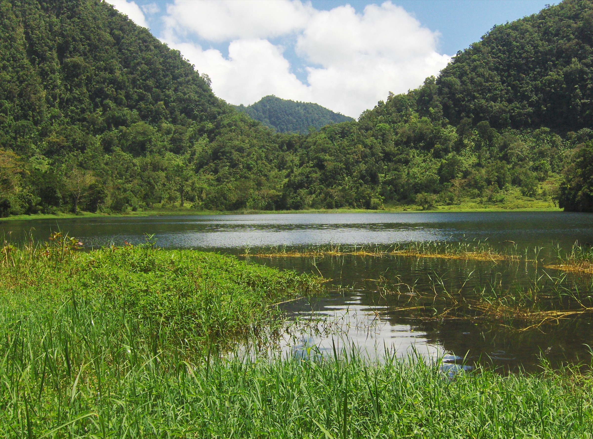
The candidate objective is an access walk to Lake Dziani Boundouni, a crater lake in south-eastern Mohéli. Ramsar identifies it as a 30 ha freshwater crater lake and one of the few freshwater lakes in Comoros. A safe, legal walking line was not verified.
Why it is essential
Dziani Boundouni is Mohéli’s most clearly documented inland crater-lake site and a Ramsar wetland. It gives the Mohéli selection a freshwater volcanic objective distinct from the marine-park coast.
Equipment
Standard hiking equipment: walking shoes or boots, rain protection, water, sun protection, and navigation backup.
Hazards and notes
Lake-edge access, cultural rules, private/cultivated land, and ecological restrictions require local confirmation. Ramsar notes unusual limnological characteristics and bird value; keep disturbance low.
GPX / KML links
| Source | URL | Format / access | Reuse status |
|---|---|---|---|
| OpenStreetMap search — Lake Dziani Boundouni | openstreetmap.org | Map data / search | OSM data is ODbL; candidate geometry cross-check only |
| Wikimedia Commons search — Dziani Boundouni | commons.wikimedia.org | Image search | Search target recorded; no reusable image candidate verified |
External links
- Ramsar Sites Information Service — Lake Dziani Boundouni
- Ramsar RIS PDF — Lake Dziani Boundouni
- Wikipedia — Mohéli National Park
3. Nioumachoua marine-park viewpoint walk

Snapshot
Itinerary
This candidate would use local paths above or near Nioumachoua for viewpoints over Mohéli National Park’s coastal and islet landscape. No official walking route, measured trail data, or GPX was verified.
Why it is essential
Nioumachoua is closely associated with Mohéli’s protected marine-park landscape and gives a hiking catalogue entry a coastal viewpoint complement to the interior ridge and lake candidates.
Equipment
Standard hiking equipment with sun protection and water.
Hazards and notes
Route access, cliffs, heat, and protected-area rules are unresolved. Boat access to islets or reef areas is outside this hiking route and not treated as a trail.
GPX / KML links
| Source | URL | Format / access | Reuse status |
|---|---|---|---|
| OpenStreetMap search — Nioumachoua | openstreetmap.org | Map data / search | OSM data is ODbL; candidate geometry cross-check only |
External links
4. Ouallah ridge-to-coast forest edge

Snapshot
Itinerary
This candidate would link a lower ridge or forest-edge track above Ouallah with coastal views inside Mohéli National Park. No public route statistics or route file were verified.
Why it is essential
Ouallah provides a potential ridge-to-coast expression of Mohéli’s protected landscape and connects the island’s terrestrial slopes with its better-known marine park.
Equipment
Standard hiking equipment, with rain protection, water, sun protection, and navigation backup.
Hazards and notes
Access through village land, steep or muddy paths, heat, and national-park rules require local confirmation.
GPX / KML links
| Source | URL | Format / access | Reuse status |
|---|---|---|---|
| OpenStreetMap search — Ouallah | openstreetmap.org | Map data / search | OSM data is ODbL; candidate geometry cross-check only |
External links
5. Fomboni / Djoièzi north-slope highland candidate

Snapshot
Itinerary
The candidate objective is a north-slope highland walk from the Fomboni / Djoièzi side toward the island interior. The sector is useful for access because Fomboni is the island capital and the airport lies between Fomboni and Djoièzi, but no mapped route was verified.
Why it is essential
If confirmed, this route would give the catalogue an accessible northern approach to the Mohéli highlands, balancing the southern park and crater-lake candidates.
Equipment
Standard hiking equipment: sturdy footwear, rain layer, water, sun protection, and navigation backup.
Hazards and notes
This is a research candidate only. Trail existence, land access, route length, and highland turnaround points need local verification.
GPX / KML links
| Source | URL | Format / access | Reuse status |
|---|---|---|---|
| OpenStreetMap search — Fomboni / Djoièzi | openstreetmap.org | Map data / search | OSM data is ODbL; candidate geometry cross-check only |
| Wikimedia Commons search — Fomboni highlands | commons.wikimedia.org | Image search | Search target recorded; no reusable image candidate verified |
External links
External links
| Source | URL |
|---|---|
| Wikipedia — Mohéli National Park | en.wikipedia.org |
| Wikipedia — Mohéli | en.wikipedia.org |
| Protected Planet — Parc National de Mohéli | protectedplanet.net |
| Ramsar Sites Information Service — Lake Dziani Boundouni | rsis.ramsar.org |
| Ramsar RIS PDF — Lake Dziani Boundouni | rsis.ramsar.org |