Regional overview
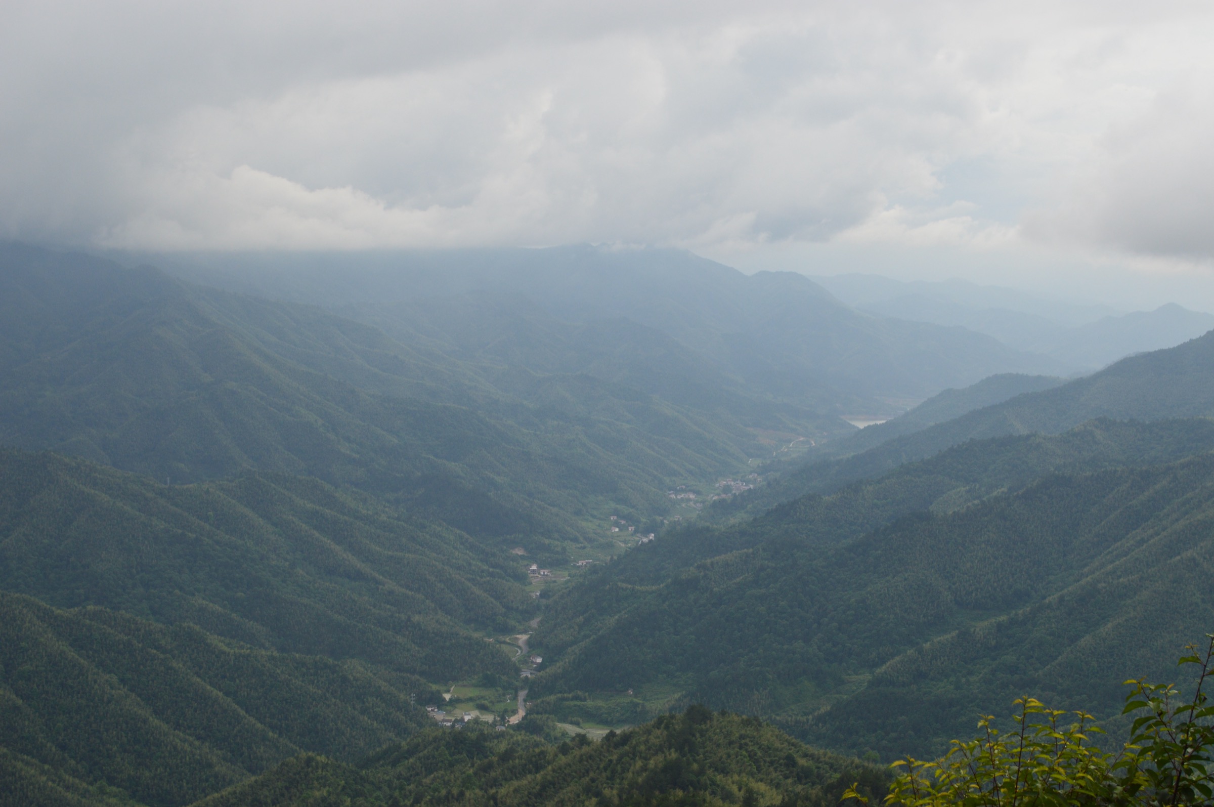
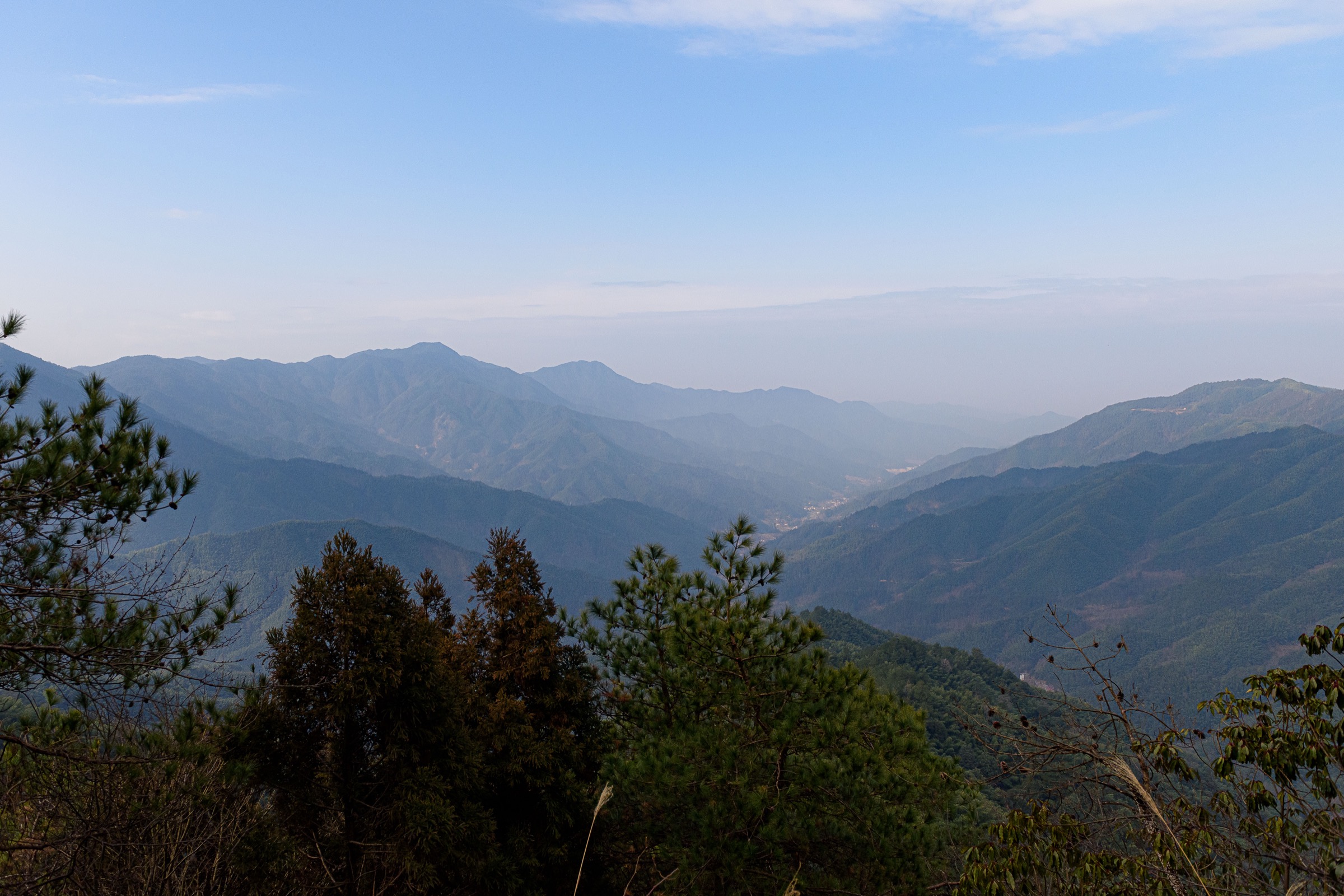
Jinggangshan (井冈山) sits at the southern end of the Luoxiao range on the Jiangxi–Hunan border, a knot of Mesozoic granite intrusions cut by V-shaped river valleys, stepped waterfalls and pseudokarst on the softer shales that flank the harder cores. The protected core — Jinggangshan National Nature Reserve, around 29,053 ha — has been a UNESCO Man and the Biosphere Reserve since 2012 and shelters what is generally regarded as the largest continuous block of mid-subtropical primary broadleaf forest at this latitude (around 26°N). Summits across the wider range climb above 2,100 m, but the scenic peaks that hikers actually visit — Wuzhifeng (五指峰), Huangyangjie (黄洋界), Bijiashan (笔架山) — sit in the 1,300–1,800 m band, reached from the small basin town of Ciping (茨坪) at about 800 m.
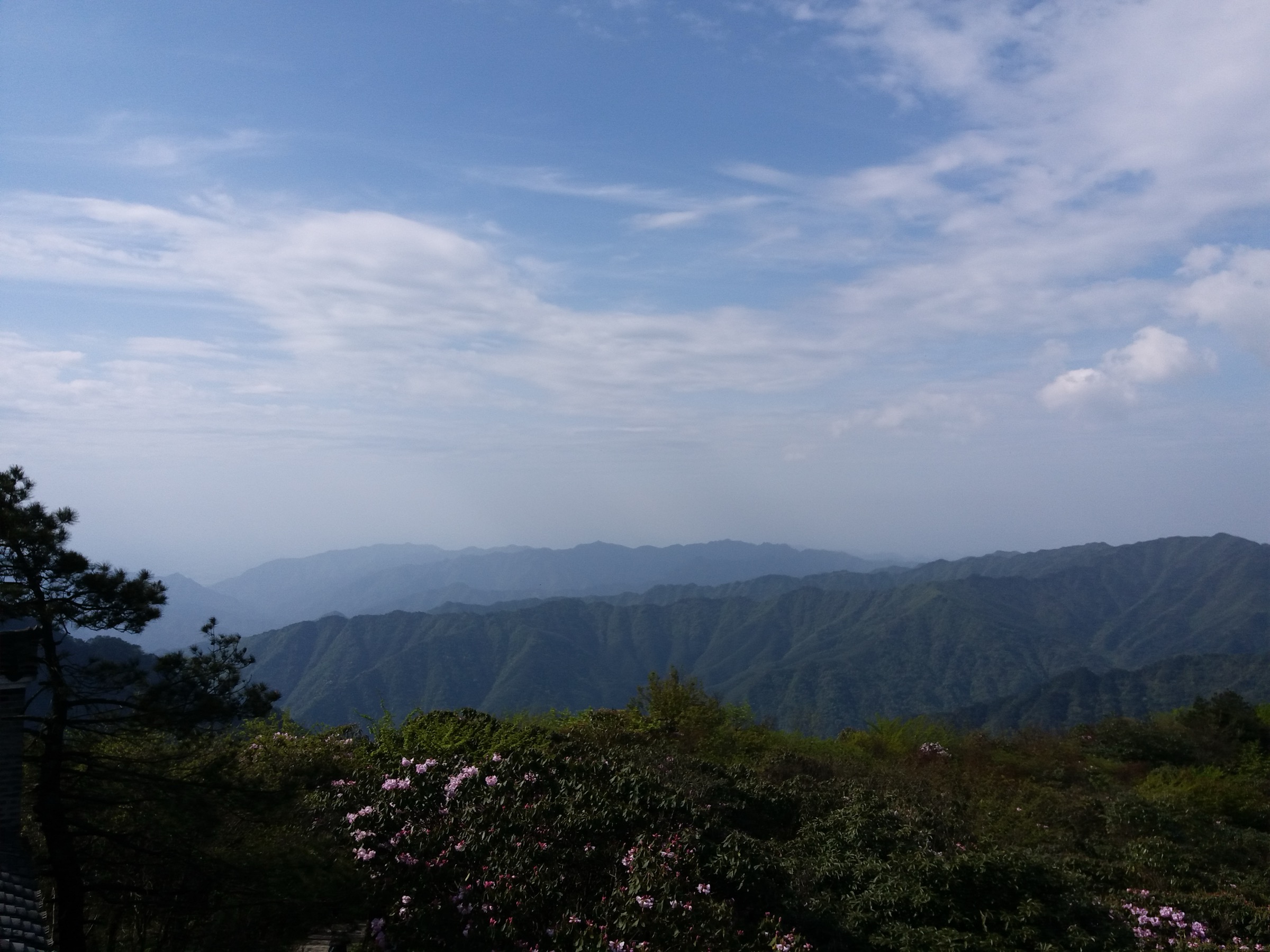
The biological inventory is large for a Chinese subtropical reserve: about 3,200 vascular plant species, more than 270 bird species, and a notable list of locally described endemics including the shrub Rhododendron jinggangshanicum, Paraphlomis jinggangshanensis (Lamiaceae) and the lace-sheet spider Psechrus jinggangensis. Chinese-language sources also refer to a “Jinggangshan tit” as a local endemic, but the taxonomic status of that taxon is not yet settled in mainstream international ornithological lists. Annual rainfall in the core averages around 1,890 mm, mean annual temperature is about 14 °C, and relative humidity sits at roughly 85 % — fog, low cloud and dripping bamboo are normal hiking conditions for much of the year.
Jinggangshan is unusual in Chinese mountain tourism for its dual identity. From October 1927 the area was Mao Zedong’s first revolutionary base, occupied by the Workers’ and Peasants’ Revolutionary Army after the failed Autumn Harvest Uprising; Mao, Zhu De and the early Red Army held the range as a Soviet base until January 1929. Ciping was the de-facto headquarters and is still ringed by surviving 1927–29 buildings — Mao’s former residence, the Red Army Hospital, the Revolutionary Museum, the Beishan Martyrs’ Cemetery. The 1928 defensive battle at Huangyangjie pass, immortalised in Mao’s poem Xī Jiāng Yuè · Jǐnggāngshān, is the single most cited piece of revolutionary geography in the country. As a result the range draws both “red tourism” pilgrim traffic and conventional mountain visitors, and the iconic sites — Huangyangjie and the Longtan waterfalls — can be very crowded during the 1 May and 1 October Golden Weeks.
Practical hiking sits inside a single combined-ticket system. A peak-season pass (Mar–Nov) costs around 190 RMB and bundles entry to roughly 22 separate scenic spots; the off-season pass (Dec–Feb) is around 150 RMB. A scenic-area shuttle bus (~60–80 RMB) is effectively mandatory because private vehicles cannot enter most trailheads, and cable cars operate at both Huangyangjie–Jiangjunyan and at Longtan (~70 RMB return at Longtan). The hiking window runs mid-March to late November; April–May brings the famous Rhododendron bloom and the “ten-mile azalea corridor” on Bijiashan; late October to early November brings deciduous colour. Midsummer is hot, humid and stormy with daily convective showers; winter brings short-lived snow and ice and occasional cable-car closures. Access is via Jinggangshan Airport (KOW), Jinggangshan railway station on the Ji-Heng line, and long-distance buses to Ciping.
Selection rationale
The five hikes below cover the geological, ecological, scenic and historical fingerprints of the range without duplicating trailheads. Huangyangjie pairs the most-photographed cloud-sea viewpoint in the southern Luoxiao with the 1928 battlefield and the Red Army grain-carrying trail. Longtan delivers the canonical waterfall canyon and the wettest example of the region’s evergreen broadleaf flora. Wuzhifeng is the postcard granite ridge — the same composition used on China’s 1999 fourth-series 100-yuan banknote — reached by a short accessible loop. Bijiashan is the only true exposed ridge walk in the standard circuit and the one route that delivers the Rhododendron spring bloom at scale. The Ciping revolutionary loop anchors the catalogue to the 1927–29 Red Army base and works as an arrival-day leg-stretcher with a modest climb up Beishan.
No packaged official GPX was located for any of the five hikes; OpenStreetMap coverage of the formal stepped trails is partial. Field GPS or a manually traced OSM route is the realistic option until the scenic-area authority publishes routes.
Summary table
| # | Hike | Country | Route type | Distance | Gain | Max elevation | Difficulty |
|---|---|---|---|---|---|---|---|
| 1 | Huangyangjie ridge & Red Army grain trail | China | Point-to-point (shuttle return) | 5–6 km | 200–250 m | 1,343 m | Easy–moderate |
| 2 | Longtan five-pool / eighteen-waterfall descent | China | Lift-assisted descent | 3.5 km | 30 m gain / 220 m loss | 900 m | Easy (slippery) |
| 3 | Wuzhifeng viewpoint loop | China | Out-and-back | 2–4 km | 100–150 m | 1,438 m | Easy |
| 4 | Bijiashan azalea ridge | China | Lift-assisted ridge traverse | 5–7 km | 150–250 m | ~1,700 m | Moderate |
| 5 | Ciping revolutionary loop & Beishan ascent | China | Loop | 4–6 km | 100–150 m | 900 m | Easy |
1. Huangyangjie ridge and Red Army grain trail
Snapshot
Itinerary
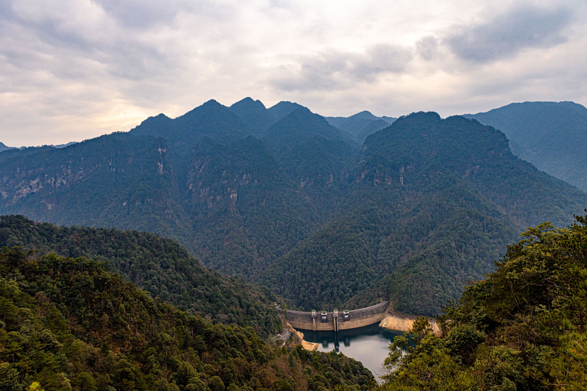
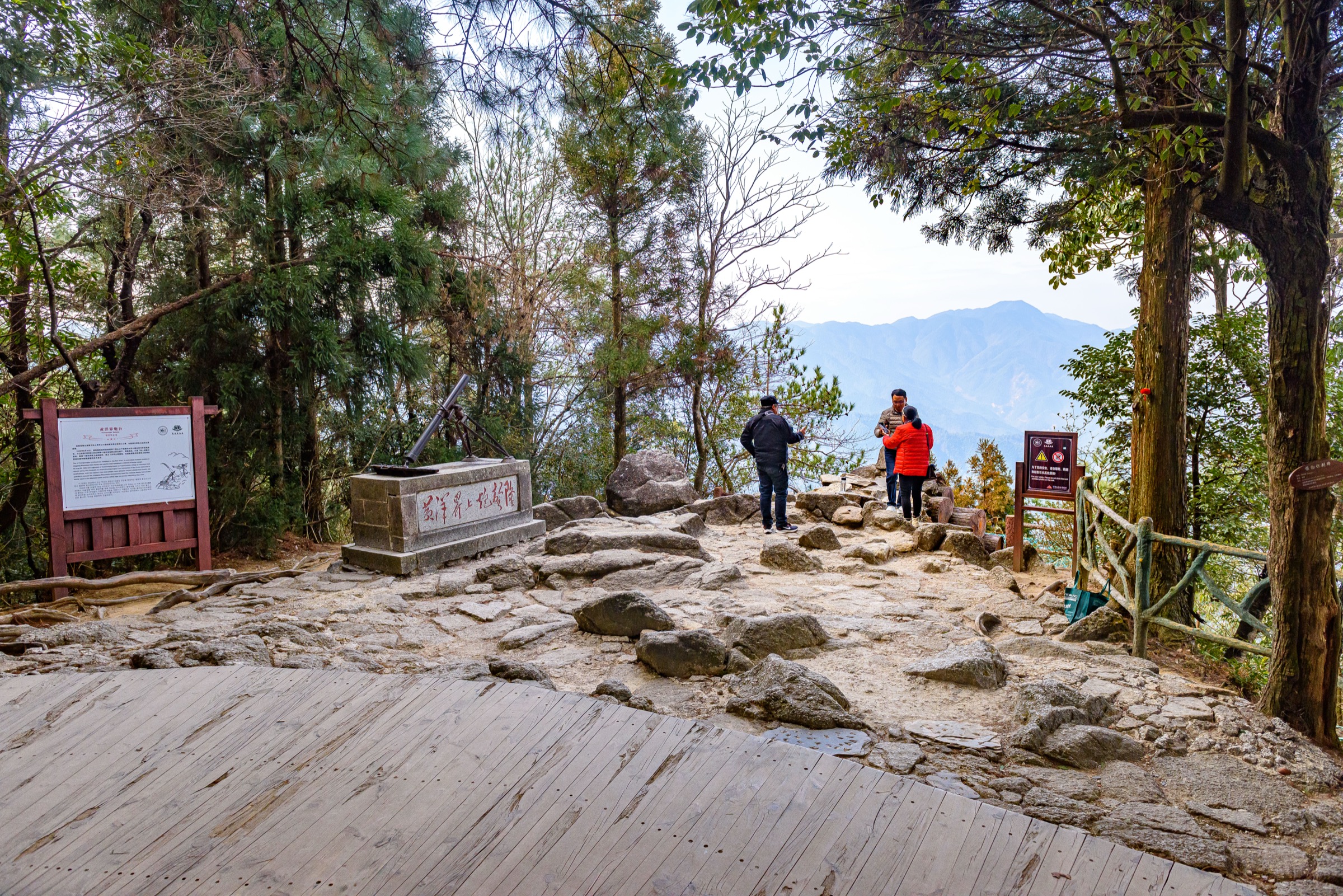
The walk starts at the Huangyangjie shuttle car park, where the scenic-area bus from Ciping (about 17 km southeast) drops visitors directly at the pass. From the car park a paved stepped path climbs roughly 50 m through forested switchbacks to the ridge crest, where the 1928 battlefield site has been preserved: a reconstructed Red Army cannon emplacement, the original stone trenches, the wooden command-post building and a tall stele carved with Mao’s Xī Jiāng Yuè · Jǐnggāngshān (“黄洋界上炮声隆”). The ridge platform sits at about 1,343 m and looks southwest across a deep granite-cored basin towards Hunan; cloud-sea conditions are common between April and October.
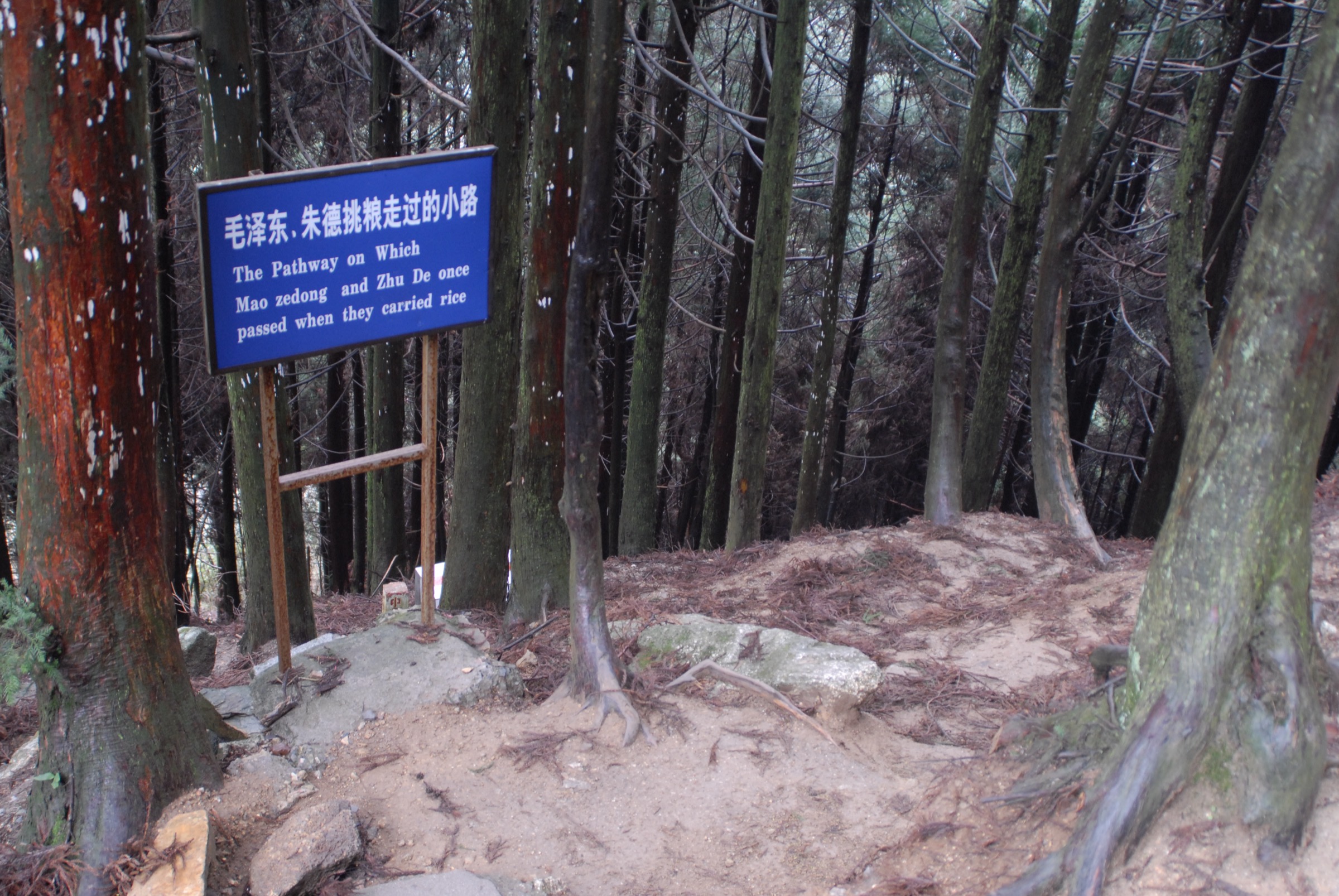
From the ridge, a flagged path drops north-west off the pass onto the historic 挑粮小道 (“grain-carrying trail”), a stone-paved ridge-and-spur footpath built and used by Red Army soldiers in 1928 to carry rice up from the Ninggang plain to feed the besieged Soviet at Ciping. The full historical trail is around 3.1 km; the signed “essence section” near Huangyangjie is about 1.5 km of well-maintained granite-block staircase descending through Phyllostachys bamboo and mixed evergreen forest. Most walkers complete the essence section as a one-way descent to a lower car park where the scenic-area shuttle can be re-boarded; fit walkers can return uphill the same way to the pass.
Why it is essential
Huangyangjie is the single most photographed landscape in Jinggangshan and the most heavily referenced piece of Chinese revolutionary geography after Yan’an. It pairs an authentic 1928 battlefield site — the Red Army’s defensive victory against four KMT encirclement campaigns — with one of the cleanest cloud-sea viewpoints in the southern Luoxiao. The grain-trail descent grounds the walk in the actual surface used by the early Red Army and provides a short but genuine forest section on stone-built infrastructure.
Equipment
- Trail shoes or light boots with good grip — the granite stone steps are smooth and very slippery when wet
- Weatherproof shell and light rain cover; mountain weather is highly changeable with sudden thunderstorms May–September
- Warm mid-layer even in summer — the ridge cools quickly when cloud rolls in
- Water, snacks, sun protection
Hazards and notes
The single busiest site in the reserve, especially around the 1 May and 1 October Golden Weeks and the 09:00–11:00 tour-bus peak; the first or last shuttle of the day is significantly quieter. The ridge platform has railings, but off-trail rocks have unprotected drops — do not cross barriers. Lightning risk on the exposed pass during summer convection is real; cloud-sea conditions can flip to thick fog with zero visibility within minutes. A separate Huangyangjie cable car operates between Jiangjunyan and the pass, useful in poor conditions or for visitors unable to climb the steps. The entire route is inside the National Nature Reserve — do not leave marked paths, collect plants or fly drones without prior permission.
GPX / KML links
| Source | URL | Format | Notes |
|---|---|---|---|
| OpenStreetMap (Huangyangjie node + footpaths) | openstreetmap.org | OSM data (export GPX) | ODbL 1.0; reusable with attribution |
| No official park GPX | — | — | Not located; build manually from OSM and field GPS |
Sources
- Baidu Baike — Huangyangjie
- Loongwander — Jinggangshan Scenic Area in Ji’an
- Wikipedia — Jinggang Mountains
2. Longtan five-pool / eighteen-waterfall descent
Snapshot
Itinerary
The walk starts at the upper Longtan cable-car station, which lifts visitors out of the valley basin to roughly the 900 m level — strongly recommended over the alternative 600-plus stepped staircase up from the lower visitor centre. From the upper station the trail enters a steeply walled granite canyon and follows a flagged stepped path past the five named pools and their eighteen cascade segments, with a combined vertical drop of around 220 m. In sequence (top to bottom) the pools are:
- Biyu Tan (碧玉潭, Jasper Pool) — a single 67 m plunge at the head of the canyon
- Suolong Tan (锁龙潭, Lock-Dragon Pool) — set in Rhododendron and bamboo
- Zhenzhu Tan (珍珠潭, Pearl Pool) — a ~30 m broken cascade
- Feifeng Tan (飞凤潭, Flying Phoenix Pool) — a narrow chute on dark granite
- Xiannv Tan (仙女潭, Fairy Pool) — the lowest and broadest, with a ~40 m drop into a wide plunge basin
The trail emerges at the lower visitor centre where the scenic-area shuttle can be picked up back to Ciping.
Why it is essential
Longtan is the type-locality for Jinggangshan’s stepped-waterfall geomorphology — a textbook example of differential erosion of jointed Mesozoic granite by a high-gradient subtropical stream. It is also the single best example of the region’s wet-canyon flora: subtropical evergreen broadleaf forest, dense Phyllostachys edulis bamboo and Jinggangshan Rhododendron species. It is the only one of the iconic Jinggangshan scenic spots set entirely inside a forested ravine.
Equipment
- Aggressive-grip footwear — stone steps and metal grating are continuously wet from spray and very slick
- Light rain shell (the trail passes through waterfall-mist sections that act like a shower)
- Trekking pole optional but useful on the steeper staircases
- Water and snacks
Hazards and notes
Slippery surfaces are the dominant hazard — slip-and-fall is the most common injury reported on the route. The trail can be closed at short notice during heavy rain or typhoon-remnant events; check at the Ciping visitor centre on the morning of the walk. Cable-car operating hours are typically 08:00–17:00 (verify locally); last upload is well before closing. Very crowded on holiday peaks; midweek mornings are noticeably quieter. Protected-area rules apply — no swimming, no leaving the path.
GPX / KML links
| Source | URL | Format | Notes |
|---|---|---|---|
| OpenStreetMap (Longtan footpath) | openstreetmap.org | OSM data (export GPX) | ODbL 1.0; reusable with attribution |
| No official park GPX | — | — | Not located in this pass |
Sources
- Trip.com — Longtan Waterfall, Jinggang Mountain
- Visit Our China — Longtan Waterfall
- Baidu Baike — Jinggangshan Longtan Waterfall Group
3. Wuzhifeng (Five-Finger Peak) viewpoint loop
Snapshot
Itinerary
The walk starts where the scenic-area shuttle terminates at the Wuzhifeng car park, set in dense Phyllostachys bamboo and mixed evergreen forest on the southwestern flank of the reserve. A paved stepped path leads roughly 1–2 km out to the principal viewing platform at around 1,438 m, set facing the five-fingered granite ridge that gives the peak its name. The view across the basin is the same composition used on the back of China’s 1999 fourth-series 100-yuan banknote, with the ridge silhouette filling the frame and the wider Luoxiao mountains rolling away to the west. Additional short spurs lead to secondary viewpoints and to the upper edge of the Shuikou bamboo plank-road forest walk, which can be combined as a longer extension if time allows.
Why it is essential
Wuzhifeng is the most reproduced single image of Jinggangshan and the principal national symbol of the range, both through the 100-yuan banknote and through almost every tourism promotional photograph. The walk to the viewing platform is short and accessible but provides the single best free-standing granite-ridge composition in the reserve. Pairing the Wuzhifeng viewpoint with either Longtan or the adjacent Shuikou bamboo trail is the standard half-day combination used by domestic visitors.
Equipment
- Trail shoes
- Sun hat and sunscreen — the viewing platform is exposed and the white granite is highly reflective
- Camera with moderate telephoto useful: the ridge sits across an air gap, not directly accessible
- Water
Hazards and notes
The main summit ridge is fenced off and not accessible to walkers; do not attempt to scramble onto it. The viewing platform has railings but unprotected drops beyond; supervise children. Heavy haze can obscure the ridge for days at a time in midsummer; late October and early November typically have the clearest air. Crowds at the platform are dense around midday tour-bus arrivals; early morning and late afternoon are quieter and have better light.
GPX / KML links
| Source | URL | Format | Notes |
|---|---|---|---|
| OpenStreetMap (Wuzhifeng viewpoint) | openstreetmap.org | OSM data (export GPX) | ODbL 1.0; reusable with attribution |
| No official park GPX | — | — | Not located in this pass |
Sources
- Baidu Baike — Wuzhi Peak
- Trip Moments — Recommended Hiking in Jinggangshan
- Wikimedia Commons — Wuzhi Peak, Jinggangshan
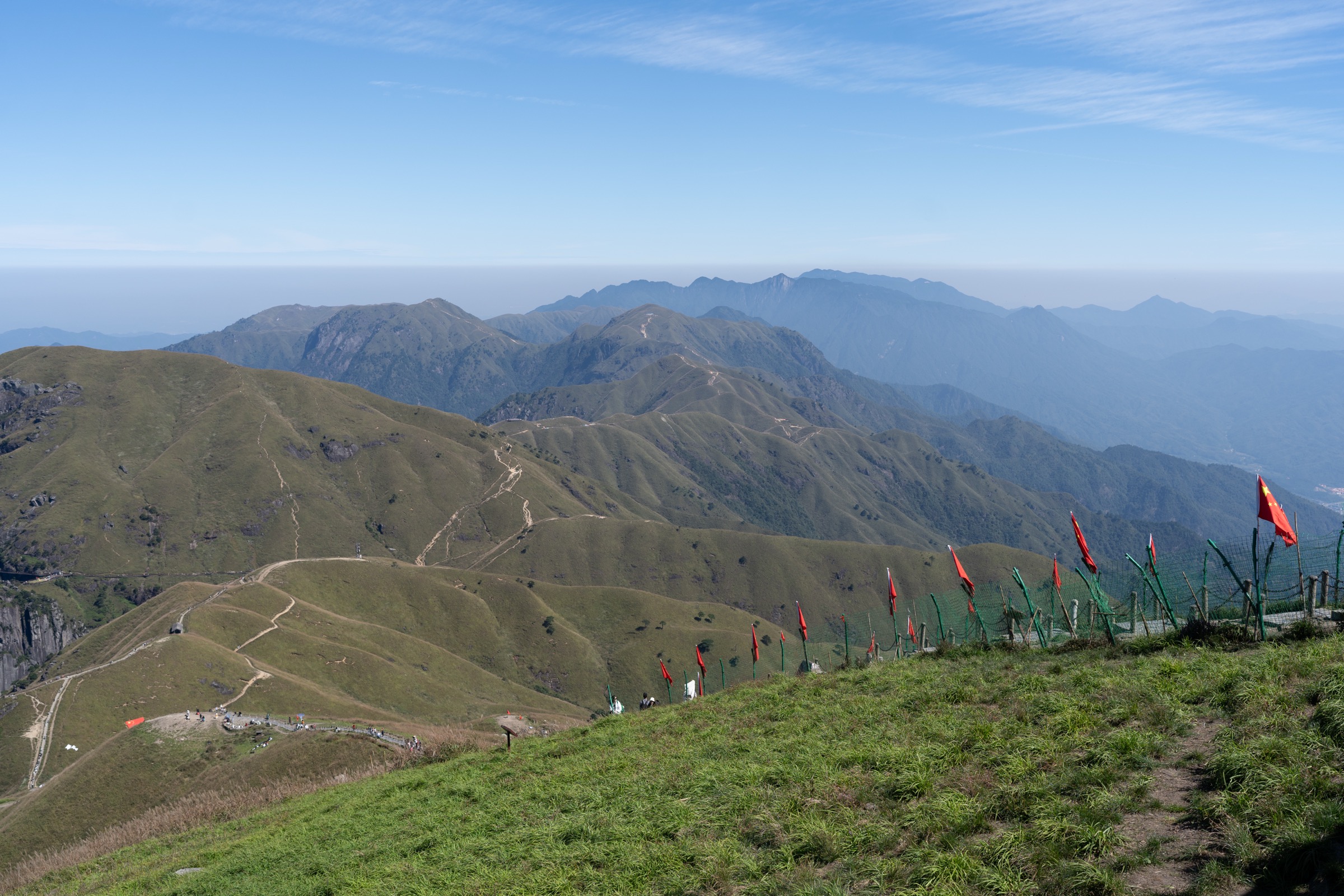
4. Bijiashan azalea ridge
Snapshot
Itinerary
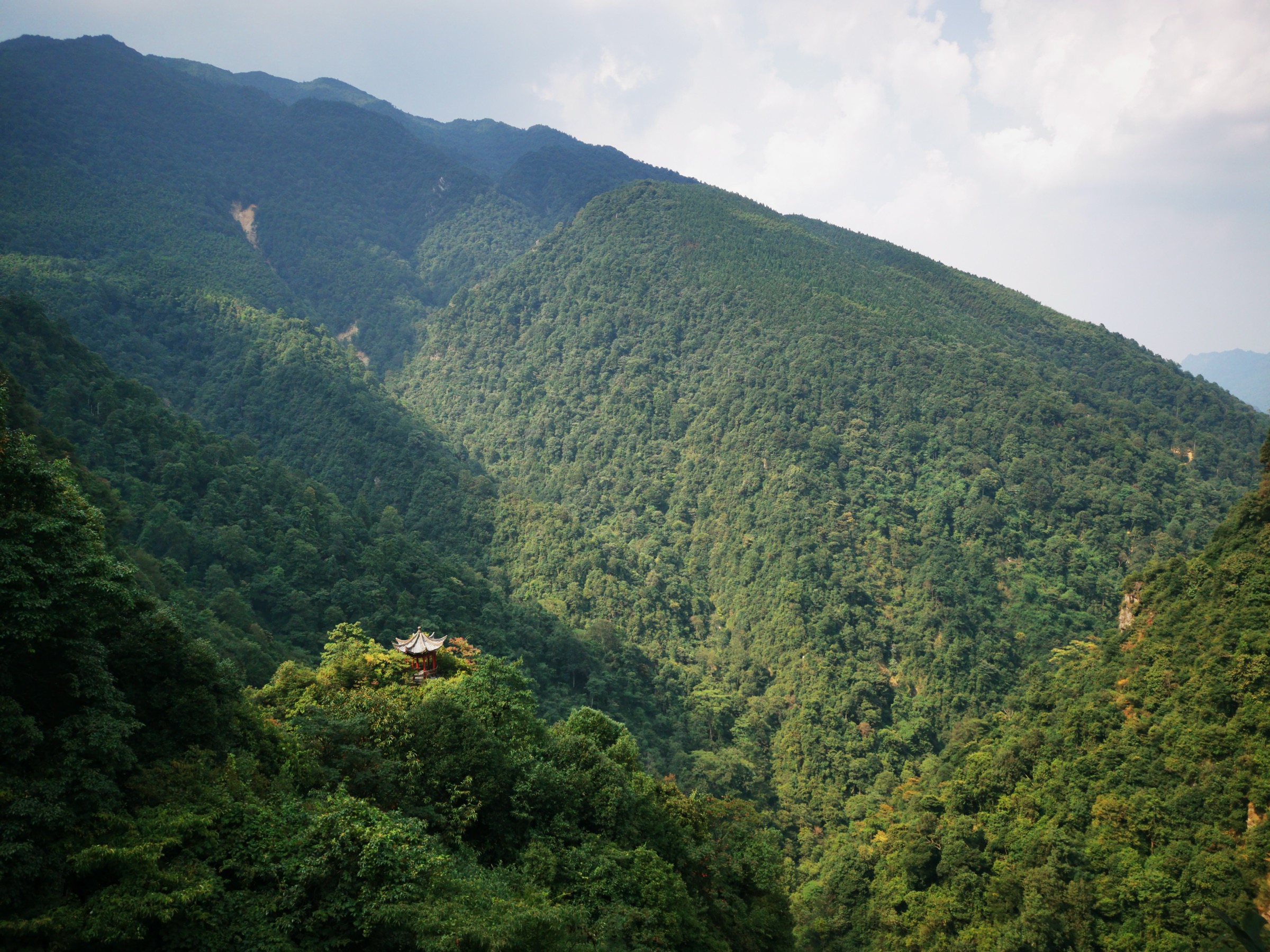
The walk begins at the Bijiashan upper cable-car station on the southern crest of the reserve. From the upper station a continuous plank-and-stair ridge walkway runs along the spine of the mountain, undulating across a series of granite knolls that gave the peak its Chinese name — a “pen rack,” the three-pointed traditional Chinese desktop stand for writing brushes. In late April and early May the ridge passes through the locally famous “ten-mile azalea corridor” (十里杜鹃长廊), dominated by Rhododendron simsii with several Jinggangshan-endemic Rhododendron taxa, including R. jinggangshanicum. The ridge offers continuous views east across the deeply cut basin towards Wuzhifeng and west into Hunan. The standard turnaround is the far viewing platform, from which the same walkway is retraced to the upper cable-car station.
Why it is essential
Bijiashan is the only true exposed ridge walk in the standard Jinggangshan circuit and the only one that delivers genuine spring botany of national significance — the azalea corridor draws domestic photographers in large numbers during the bloom window. The ridge complements the canyon walk at Longtan and the viewpoint at Wuzhifeng, giving a true balcony perspective on the granite intrusions of the southern Luoxiao.
Equipment
- Sturdy boots; trekking poles useful on the long stair sections
- Extra warm layer — the ridge is considerably cooler and windier than Ciping below
- Hat and gloves outside midsummer
- Sun protection — the ridge is open and the granite reflective
- Water and snacks for the full day
Hazards and notes
Exposed ridge — strong wind and lightning risk during summer thunderstorms; the cable car may close in storms. Stepped boardwalks become very slippery in fog and rain; railings are continuous, but drops on either side are significant. Crowds during the azalea bloom (late April to mid-May) can be very heavy; aim for the first cable car of the day. Protected-area rules apply — do not pick Rhododendron flowers.
Distance, elevation gain and summit elevation given here should be treated as approximate; they were not cross-verified against an authoritative Chinese-language survey source for this pass.
GPX / KML links
| Source | URL | Format | Notes |
|---|---|---|---|
| OpenStreetMap (Bijiashan node — partial trail coverage) | openstreetmap.org | OSM data | ODbL 1.0; coverage incomplete, field GPS recommended |
| No official park GPX | — | — | Not located in this pass |
Sources
- Wanderlust — Heavenly peaks: the mountains of Jiangxi
- Trip Moments — Recommended Hiking in Jinggangshan
- Loongwander — Jinggangshan Scenic Area in Ji’an
5. Ciping revolutionary loop and Beishan ascent
Snapshot
Itinerary
The walk starts at Torch Square (火炬广场) in the centre of Ciping, the small basin town that served as the de-facto Red Army headquarters in 1927–29. From the square, a short walk leads to Mao Zedong’s Former Residence (free entry, advance reservation required), preserving the wooden building Mao occupied during the Soviet period. The route then follows signed pavement up to the Jinggangshan Revolutionary Museum (井冈山革命博物馆 — free entry, reservation required; over 30,000 artefacts), the principal national interpretation of the 1927–29 base.
From the museum the loop climbs roughly 100 m up the wooded hill behind the town to the Beishan Martyrs’ Cemetery (北山革命烈士陵园), with its memorial halls and an open terrace overlooking Ciping. A continuation along the Beishan ridge path adds another ~2 km of forest walking through Cryptomeria and Phyllostachys bamboo, with an obvious return descent back into Ciping past the former Red Army Hospital and the Xiangshan Hotel. The loop is signed in Chinese with limited English; navigation is straightforward because the town is compact and the cemetery hill is the highest point.
Why it is essential
This walk anchors the regional catalogue to Jinggangshan’s defining historical identity — the 1927–29 Workers’ and Peasants’ Revolutionary Army base. None of the other four hikes pass through the surviving early-Red-Army built fabric. The Beishan extension turns what would otherwise be a flat town stroll into a modest hill walk with a panoramic outlook over the basin, and the route works well as an arrival-day leg-stretcher before the longer Huangyangjie, Longtan and Wuzhifeng days.
Equipment
- Trail shoes — sufficient for the loop
- Reservation bookings on the official museum and residence WeChat platforms (free but required)
- Passport / ID for site entry
- Water and snacks
Hazards and notes
Reservation system: free sites require advance booking via Chinese-language platforms; foreign visitors typically book through their hotel or a local guide. Photography restrictions inside parts of the Revolutionary Museum — check signage. Crowds are very heavy during the 1 May and 1 October Golden Weeks (this is one of the principal Chinese “red tourism” pilgrimage sites). The Beishan Martyrs’ Cemetery is treated as a place of national mourning; subdued behaviour and quiet voices are expected. Town traffic on the lower sections; no significant outdoor hazard, but the Beishan ridge paths can be muddy after rain.
GPX / KML links
| Source | URL | Format | Notes |
|---|---|---|---|
| OpenStreetMap (Ciping town centre + Beishan paths) | openstreetmap.org | OSM data | ODbL 1.0; reusable with attribution |
| No official park GPX | — | — | Not located in this pass |
Sources
- Trip.com Moments — Ciping Scenic Area travel guide
- Trip Moments — Jinggangshan Revolution Museum guides
- Baidu Baike — Jinggang Mountains Revolutionary Sites
- China Wonders Guide — Jinggangshan: Red Tourism China
External links
| Source | URL |
|---|---|
| UNESCO MAB Programme — Jinggangshan Biosphere Reserve | unesco.org |
| Chinese Academy of Sciences — Jinggangshan Biosphere Reserve | english.cas.cn |
| UNESCO World Heritage Tentative List — Jinggangshan / North Wuyishan extension | whc.unesco.org |
| Lu et al. — Biodiversity of Jinggangshan Mountain (PLOS ONE) | journals.plos.org |
| Shen et al. — Seed Plant Flora of Mount Jinggangshan (PLOS ONE) | journals.plos.org |
| Wikipedia — Jinggang Mountains | en.wikipedia.org |
| PeakVisor — Jinggangshan City | peakvisor.com |
| Trip.com — Jinggangshan destination hub | trip.com |
| TravelChinaGuide — Mt. Jinggang | travelchinaguide.com |
| Wikimedia Commons — Category:Jinggang Mountains | commons.wikimedia.org |
| Wikimedia Commons — Category:Huangyangjie | commons.wikimedia.org |
| OpenStreetMap — Jinggangshan area | openstreetmap.org |