Regional overview
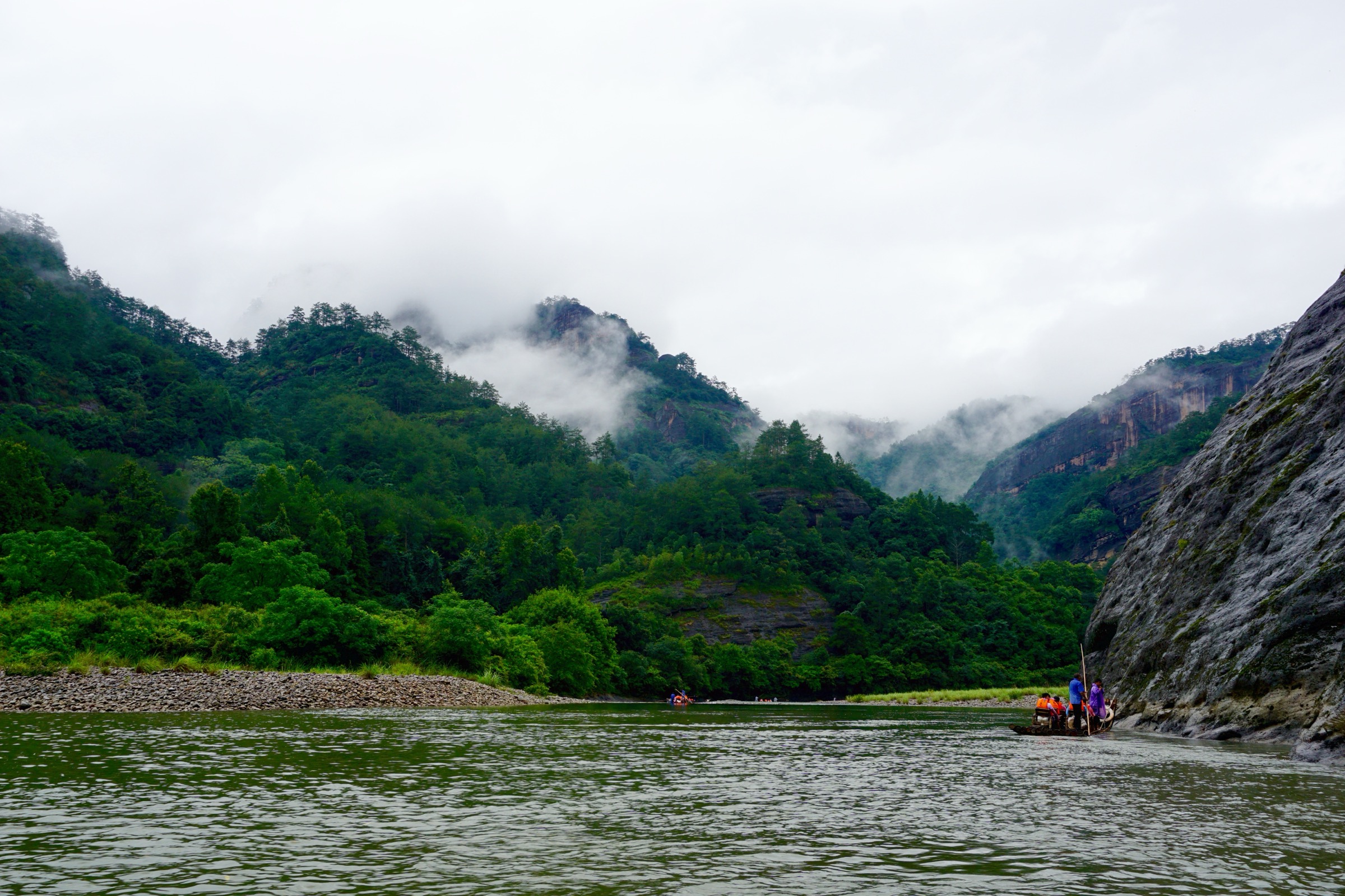
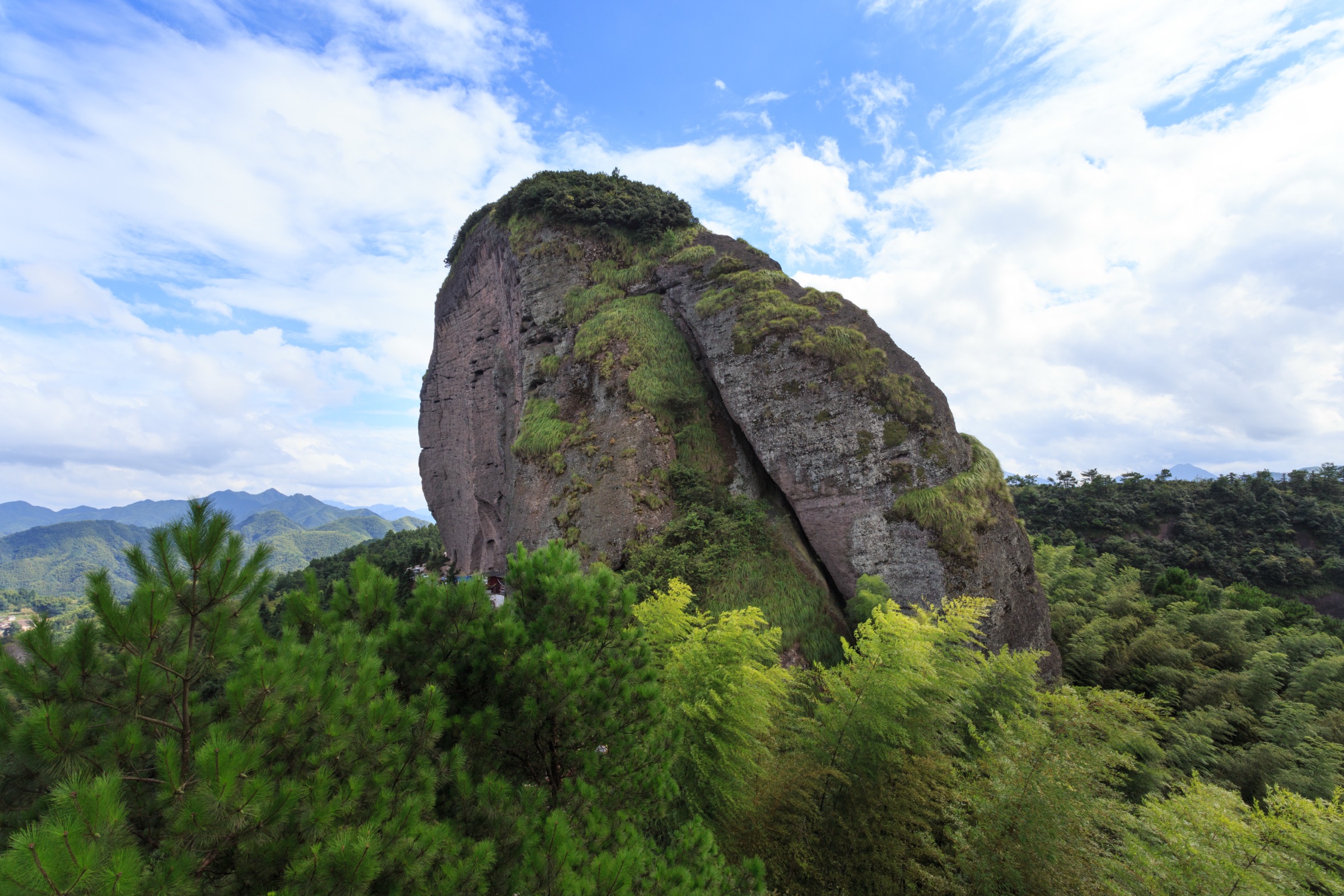
The northeast Fujian coast — the Mindong (闽东) region administered from Ningde city — is the seaward extension of the Wuyi mountain system, where the granite-and-volcanic ridges that form the Fujian–Jiangxi watershed step down through a series of coastal foothills, peninsulas and offshore islands toward the Taiwan Strait. The defining range here is Mount Taimu (太姥山, 917 m) in Fuding (福鼎), a UNESCO Global Geopark inscribed in 2010 for its granite peak-forest geology — a dense set of vertically jointed granite spires and slot-caves that rise straight out of the coastal plain less than 10 km from the sea. South of Taimu, the coastal-mountain belt continues through Baiyun Shan (白云山, 1,450 m) above Fu’an — also UNESCO-listed as part of the Ningde Geopark for its U-shaped river-eroded canyons and glacial pothole fields — and out to the offshore highlands of Dayushan (大嵛山, 541 m), the largest of the Fuding islands, whose flat summit grassland and crater lake make it the canonical island day-walk of the Fujian coast.
Walking here is a mix of managed scenic-area routes and lesser-developed back-country tracks. The Taimu and Baishuiyang scenic areas are gated and ticketed, with engineered stone-step paths, cliff stairways and shuttle access to the trailheads; the Dayushan island circuit and the upper Baiyun Shan ridge are less managed and require self-supported navigation on rougher tracks. Distances are short by mainland-China standards — most routes run 3-10 km — but cumulative ascent on the cliff-stair and canyon-stair sections is significant, and humidity, exposure and the typhoon-season afternoon thunderstorms are the binding constraints for safe scheduling.
The walking season runs October to early December and March to early May. October–November gives the cleanest light and the lowest crowd density of the year; March–April is the azalea bloom on the Taimu and Baiyun ridges. June–September is hot (28-35 °C), humid and exposed to typhoon landfalls along this stretch of coast (Ningde averages two direct hits per year); the scenic-area authorities close the granite cliff stairs and the canyon walkways during warnings. December–February is cool (5-15 °C at sea level, near zero on the Baiyun ridge) and dry but the higher routes can be frosty at dawn. Avoid the Qingming (early April) and National Day (early October) holiday weeks, when the Taimu and Baishuiyang ticket queues exceed two hours.
Access is straightforward. The Hangzhou–Fuzhou (Hangshen) high-speed line runs the length of coastal northeast Fujian with stops at Fuding, Taimu Shan, Ningde and Fu’an; intercity buses, scenic-area shuttles and taxis cover the remaining distance from each station to the trailheads in 20-60 minutes. The Dayushan island circuit requires a passenger ferry from Sansha (三沙) harbour in Xiapu county (~30 min crossing, several daily sailings October–May).
For the broader Wuyi system, see also the Wuyi Shan Scenic Region (Fujian) roundup, which covers the UNESCO core scenic area on the Jiangxi border, and the Fujian–Jiangxi watershed roundup for the high-elevation interior. The present page is the coastal-margin and offshore-island companion to those interior catalogues.
Selection rationale
Five day-hikes are presented, spanning the essential walking set on the northeast Fujian coast: the iconic Mount Taimu main scenic loop through the granite peak-forest, the Baishuiyang flat-bed stream and Yuanyangxi canyon geo-walk in Pingnan, the Jiulong waterfall stack above Zherong, the Dayushan island grassland circuit off Fuding, and the harder Baiyun Shan U-canyon and pothole-field traverse above Fu’an.
The selection balances the canonical granite scenic area (Taimu), the canonical canyon-and-stream geo-park (Baishuiyang), the canonical waterfall stack (Jiulong), the canonical island walk (Dayushan) and the canonical hill challenge (Baiyun Shan). Several routes carry estimated or unresolved distance and ascent figures — the scenic-area authorities do not publish standardised route data and public GPX/KML coverage is limited; this page distinguishes between verified route character (peak coordinates, OSM named ways, photographic confirmation) and unverified statistics. Multi-day traverses linking Taimu to Baiyun Shan over the inland watershed are out of scope as tramps rather than day-hikes, and the offshore Sandu’ao and Niangniang dao boat-and-walk combinations are excluded as primarily water-borne.
Summary
| # | Hike | Section | Route type | Distance | Gain | Max elevation | Difficulty |
|---|---|---|---|---|---|---|---|
| 1 | Mount Taimu main scenic loop | Fuding | Loop | ~6.8 km | ~600–750 m | 917 m | Moderate to hard |
| 2 | Baishuiyang and Yuanyangxi canyon | Pingnan | Linear scenic-area walk | ~6–8 km | ~300–450 m (est.) | ~600 m (est.) | Easy to moderate |
| 3 | Jiulong waterfall stack | Zherong | Out-and-back / short loop | ~3.1 km | ~250 m (est.) | ~520 m (est.) | Moderate |
| 4 | Dayushan island Tianhu grassland circuit | Fuding islands | Loop | ~6–8 km | ~400–500 m | 541 m | Moderate |
| 5 | Baiyun Shan U-canyon and pothole field | Fu’an | Out-and-back with canyon stair | ~8–10 km | ~700–900 m | 1,450 m | Hard |
1. Mount Taimu main scenic loop

Snapshot
Itinerary
From the upper shuttle terminus at the Mount Taimu scenic-area main gate, the standard loop walks the engineered stone path north past the Yuhu Pavilion (玉湖亭) into the lower granite peak-forest. The route then climbs the Tongtian Cave (通天洞, “Reach Heaven Cave”) stair — a vertical body-width slot cut through a granite fin — into the central peak-forest plateau, with named cliff features (Seven Stars Cave, One Tile Temple, Drip Cave, Heart Rock) signed in sequence along the route. From the plateau the upper stair climbs to the Mount Taimu summit (太姥山, 917 m), where the granite spires give a clear sightline over the coastal plain to the Taiwan Strait. Descend by the Black Dragon Ridge (乌龙岗) trail past the Five Hundred Arhats Hall (五百罗汉堂) and the Taimu Goddess Temple (太姥娘殿) to close the loop back at the shuttle terminus.
Why it is essential
Mount Taimu is the canonical day-hike of coastal northeast Fujian and the only walking route on the Fujian coast that combines a UNESCO-listed granite peak-forest with sea-edge geology — the spires rise less than 10 km from the Taiwan Strait, and the upper viewpoints give a sightline that no other granite mountain in south China matches. The loop is dense with named cliff features and slot-cave traverses, and the One Tile Temple (一片瓦) Taoist hermitage on the descent gives the route a cultural anchor. As a single day this is the most efficient introduction to the coastal-mountain belt that defines the Mindong region.

Equipment
- Light hiking shoes with grippy soles (stone stairs and wet cave floors)
- Trekking poles for the descent
- Small daypack (large packs catch in the slot caves)
- 2 L water and a snack
- Sun protection (the summit is fully exposed)
- Waterproof layer (afternoon thunderstorms develop quickly)
- Headlamp (some cave sections are dim)
- Cash or mobile payment for scenic-area entry and shuttle
Hazards and notes
- Slot caves narrow to body width in several places — uncomfortable for tall walkers and large packs.
- Stone stairs are slippery after rain; the descent is the main injury vector.
- The summit and upper stair close during typhoon warnings and on heavy-rain days; confirm at the South Gate before purchasing a ticket.
- Cliff-edge viewpoints have low railings; do not lean.
- Scenic-area opening hours typically 07:00–17:30 in peak season, 07:30–17:00 in low season.
2. Baishuiyang and Yuanyangxi canyon

Snapshot
Itinerary
From the Baishuiyang scenic-area lower gate, walk down to the Baishuiyang flat river bed (白水洋, “White Water Ocean”) — a 0.8 km² near-horizontal slab of polished granite over which the river runs in a sheet less than 5 cm deep, the defining geo-feature of the Pingnan Geopark. Cross the flat bed (water-shoes or barefoot in season) past the Cangtan Waterfall (仓潭瀑布) at the downstream cut-off, then climb the Yuanyangxi (鸳鸯溪, “Mandarin Duck Stream”) canyon stair — a long engineered cliff path through the inner gorge, past the Sky-high Pavilion (摩天仙阁), Thread Waterfall (一线瀑) and Cliff Road (凌云栈道) to the upper canyon rim. Return by the scenic-area shuttle from the upper canyon stop, or backtrack on foot.
Why it is essential
Baishuiyang is the only mainland Chinese landscape where a river runs in a transparent sheet across a kilometre-scale flat granite slab — a geo-feature unique enough that the Pingnan complex was inscribed as a UNESCO Global Geopark in 2010. Pairing the flat bed with the Yuanyangxi canyon stair gives the route a complete vertical section through the granite landscape, from the polished horizontal river bed at the base to the cliff-cut inner gorge above. As a single day this is the canonical geo-walking entry to inland northeast Fujian.
Equipment
- Light walking shoes for the canyon stair; water-shoes or sandals for the flat bed (changes by season)
- Quick-dry clothes (the flat bed is partly wet wading)
- 1.5 L water and a snack
- Sun protection (the flat bed is fully exposed)
- Waterproof layer
- Insect repellent in summer
- Cash or mobile payment for scenic-area entry and shuttle
Hazards and notes
- The flat bed is slick where algal mats develop in late summer; walk slowly and watch for sudden depressions.
- The Yuanyangxi canyon stair is cliff-edge with low railings in places; do not lean.
- Flash floods on the flat bed occur after upstream thunderstorms — leave the river immediately at first dark cloud or rising water.
- Scenic-area opening hours typically 07:30–17:00; the flat-bed wading section closes earlier.
- The flat bed dries to a near-static shallow pool October–March; for the sheeting-water effect aim for May–September.
3. Jiulong waterfall stack
Snapshot
Itinerary
From the Jiulong waterfall scenic-area gate in Zherong county, the engineered stone path follows the right bank of the Jiulong stream (九龙溪, “Nine Dragon Stream”) upstream past a sequence of named cascades — the lower Long-Pool Fall, the middle Dragon-Mouth Fall, and the higher Nine Dragon Main Fall with a vertical drop estimated at 45 m. Short side loops branch off the main path at each cascade level. The upper viewpoint is reached by a steep stair past the head of the main fall, with the basin and the Zherong county hills laid out below. Return by the same line.
Why it is essential
The Jiulong stack is the most concentrated waterfall sequence in the Mindong coastal-mountain belt — five named falls in less than 1.5 km of vertical distance — and gives a half-day water-hike that complements the dry granite peak-forest of Taimu and the flat-bed geology of Baishuiyang. The route is short, accessible from the same HSR base as Taimu, and gives a quiet, water-focused alternative to the more heavily ticketed scenic areas elsewhere on the coast.
Equipment
- Grippy walking shoes (stone stairs are wet year-round at the cascade levels)
- Trekking poles for the descent
- Waterproof layer (spray zone at the main fall)
- 1.5 L water and a snack
- Camera with a polariser if you want the falls without sky glare
- Cash for scenic-area entry
Hazards and notes
- Stone stairs are slippery in the spray zone year-round.
- Flow is heaviest May–September; the falls are reduced to a thread December–February.
- Avoid the canyon after sustained heavy rain — runoff can spike the stream within minutes.
- The upper stair has cliff-edge sections with low railings.
- Scenic-area opening hours typically 08:00–17:00; confirm seasonal variation at the gate.
4. Dayushan island Tianhu grassland circuit
Snapshot
Itinerary
From the Aoshan village ferry pier on the west side of Dayushan, the island path climbs steeply through subtropical scrub onto the Tianhu grassland plateau (天湖大草原) — a kilometre-square open grassland that sits in the saddle between the island’s two main summits, the only landscape of its kind on the Fujian coast. The route loops across the grassland past the two Tianhu crater lakes (天湖) — small near-circular lakes in shallow basins, the source of the island’s drinking water — and continues to the Dayushan summit (541 m), the island high point, with a full-circle view over the Fuding island group, the Sansha headland and the East China Sea. Descend on the eastern cliff path past the Eastern Lighthouse and the sea-facing cliffs to Dayu village (大嵛村) on the north shore, then walk the coastal lane back to the Aoshan pier.
Why it is essential
Dayushan is the canonical island walk of the Fujian coast and the only northeast Fujian day-hike where the entire route is sea-girt — the grassland plateau is visible from passing ferries as a high open dome above the surrounding scrub, and the summit view opens to a 360° arc with no mainland horizon. The combination of crater-lake basin, kilometre-square grassland and east-facing sea cliffs has no equivalent on the mainland coast. As a single-day excursion (ferry both ways plus 4-5 h on the ground) it is one of the most efficient sea-and-mountain combinations in south China.
Equipment
- Walking shoes with grippy soles (some sections are wet sandy track)
- Trekking poles optional but useful on the cliff descent
- 2 L water (no reliable refill on the island)
- Food for the day (kiosks at Aoshan and Dayu villages are seasonal)
- Sun protection (the grassland is fully exposed)
- Wind shell (the plateau is exposed and the ridge wind is constant)
- Cash for ferry and any village stop
- Offline OSM map and downloaded ferry schedule
Hazards and notes
- Ferry sailings cancel routinely on wind-warning days; check Sansha harbour notice the night before.
- The grassland plateau is exposed to wind year-round; afternoon thunderstorms in summer develop quickly.
- Cliff path on the east descent has unguarded sections; do not approach the edge in wind.
- Mobile coverage is patchy in the eastern grassland; tell someone your plan.
- The island has limited drinking water; carry your own supply.
5. Baiyun Shan U-canyon and pothole field
Snapshot
Itinerary
From the Baiyun Shan Jiulong canyon gate in Fu’an, the route walks down to the Jiulong (九龙) canyon floor — a 1.5 km section of the U-shaped river-eroded canyon that anchors the geo-park’s UNESCO listing — past the Jiulong glacial pothole field, where Pleistocene glacial meltwater carved a dense cluster of near-circular potholes into the canyon-floor granite. From the upper canyon the route climbs the engineered stair through forested switchbacks, gaining altitude steadily on the watershed flank, until it tops out at the Baiyun Shan summit (白云山, 1,450 m) — the highest point in the coastal-mountain belt and the source of clean views over the Mindong region back to the East China Sea. Return by the same line; alternative descents are not formally maintained.
Why it is essential
Baiyun Shan is the harder, higher counterpoint to Taimu — a full-day route with three times the cumulative ascent and a summit that sits a third of a kilometre above any other coastal-mountain high point. The U-canyon and pothole-field section at the base gives the route a UNESCO-listed geo-feature unique on the Fujian coast (the potholes are the largest known glacial pothole concentration in low-latitude China), and the summit ridge gives the long-distance view back over the Taimu range and out to sea. As a single day this is the most committing walk in the coastal-mountain catalogue.
Equipment
- Hiking shoes or light boots (rougher path above the canyon)
- Offline OSM map and GPS (upper route is less signed than the canyon)
- 2.5 L water and food for the day
- Sun protection
- Waterproof and warm layers (the summit is 10 °C cooler than the base)
- Headlamp (the descent may run late)
- Cash or mobile payment for scenic-area entry
Hazards and notes
- The canyon stair is slippery year-round in the spray zone of the pothole field.
- Upper ridge is exposed to wind and lightning; descend immediately at first thunder.
- Frost on the summit December–February makes the upper rock sections committing — light traction may help.
- The scenic-area gate closes at 17:00; aim to be off the upper ridge by 14:30 to comfortably finish the descent.
- Mobile coverage is patchy above the canyon; tell someone your plan.
Routes excluded as out of scope
The following sit inside or adjacent to the northeast Fujian coastal-mountain region but fall outside a day-hike entry, or duplicate routes covered in sister catalogues.
- Sansha and Niangniang dao island-and-walk combinations. Marketed as “hiking + ferry” packages but predominantly water-borne; not a walking entry.
- Sandu’ao deep-water bay village walks. Flat coastal lane walks rather than mountain routes; an excellent half-day cultural add-on but not a hike.
- Xiapu mudflat tide-walking circuits. A foreshore wading walk on the photogenic Xiapu mudflats; a specialist coastal-photography route rather than a mountain hike.
- Linking traverse Taimu–Yangtouding–Baiyun Shan. A multi-day inland traverse along the watershed; out of scope as a tramp rather than a day-hike.
- Pingnan upper-canyon raft-and-walk packages. Marketed inside the Baishuiyang–Yuanyangxi geo-park but predominantly water-borne; not a walking entry.
Further reading
| Source | URL |
|---|---|
| UNESCO Global Geoparks Network — Taining and Fujian sites | unesco.org |
| UNESCO Global Geopark — Ningde (Taimu, Baishuiyang, Baiyun Shan) | globalgeoparksnetwork.org |
| Fujian Provincial Department of Culture and Tourism | whhly.fujian.gov.cn |
| Ningde municipal government | ningde.gov.cn |
| Wikipedia — Mount Taimu | en.wikipedia.org |
| Wikipedia — Baishuiyang | en.wikipedia.org |
| Chinese Wikipedia — Taimu Shan (太姥山) | zh.wikipedia.org |
| Chinese Wikipedia — Baiyun Shan, Fu’an (白云山 (福安)) | zh.wikipedia.org |
| Chinese Wikipedia — Dayushan (大嵛山岛) | zh.wikipedia.org |
| AllTrails — Mount Taimu loop | alltrails.com |
| AllTrails — Jiulong waterfall trail | alltrails.com |
| OpenStreetMap (ODbL 1.0) | openstreetmap.org |