Regional overview
The central Hebei Taihang region around Shijiazhuang combines sandstone cliffs, cliff temples, forested high ridges, waterfalls, and managed scenic-area stair routes. Cangyan Mountain is the best-known cultural mountain route, while Zhangshiyan, Tuoliang, Wuyuezhai, and Tiangui Mountain represent the broader central Taihang walking landscape.
Most hikes in this entry are scenic-area routes rather than backcountry trails. Published English route statistics are limited, and official pages often describe areas, peaks, attractions, and suggested itineraries without GPX-grade trail distances. Where no strong route statistics were found, distances are deliberately approximate and marked unresolved.
The best season is generally April-October, with autumn clear weather and summer waterfall/forest appeal. High routes such as Tuoliang and Wuyuezhai can be cold and exposed outside summer. Winter ice on steps, cliff paths, and shaded gorges can make even managed scenic routes hazardous.
Selection rationale
The five hikes below cover the region’s essential day-walking variety: Cangyan’s cliff temple route, Zhangshiyan’s red sandstone landform, Tuoliang’s high mountain summit, Wuyuezhai’s forest-waterfall and high-peak route, and Tiangui Mountain’s Daoist mountain circuit.
Summary table
| # | Hike | Country | Route type | Distance | Gain | Max elevation | Difficulty |
|---|---|---|---|---|---|---|---|
| 1 | Cangyan Mountain temple and Bridge Tower Hall circuit | China | Loop / out-and-back | Approx. 3-5 km | Approx. 300-500 m | Approx. 1,000 m | Moderate |
| 2 | Zhangshiyan cliff and Huang’annao route | China | Loop / out-and-back | Approx. 8-12 km | Approx. 500-800 m | 1,774 m | Moderate-hard |
| 3 | Tuoliang Mountain main peak | China | Out-and-back / loop | Approx. 8-12 km | Approx. 600-900 m | 2,281 m | Hard |
| 4 | Wuyuezhai: Yinhe Gorge and Wuyue Peaks | China | Loop / out-and-back | Approx. 8-12 km | Approx. 600-900 m | 2,281 m | Hard |
| 5 | Tiangui Mountain Daoist peak circuit | China | Loop / out-and-back | Approx. 4-8 km | Moderate |
1. Cangyan Mountain Temple and Bridge Tower Hall Circuit
Snapshot
Itinerary
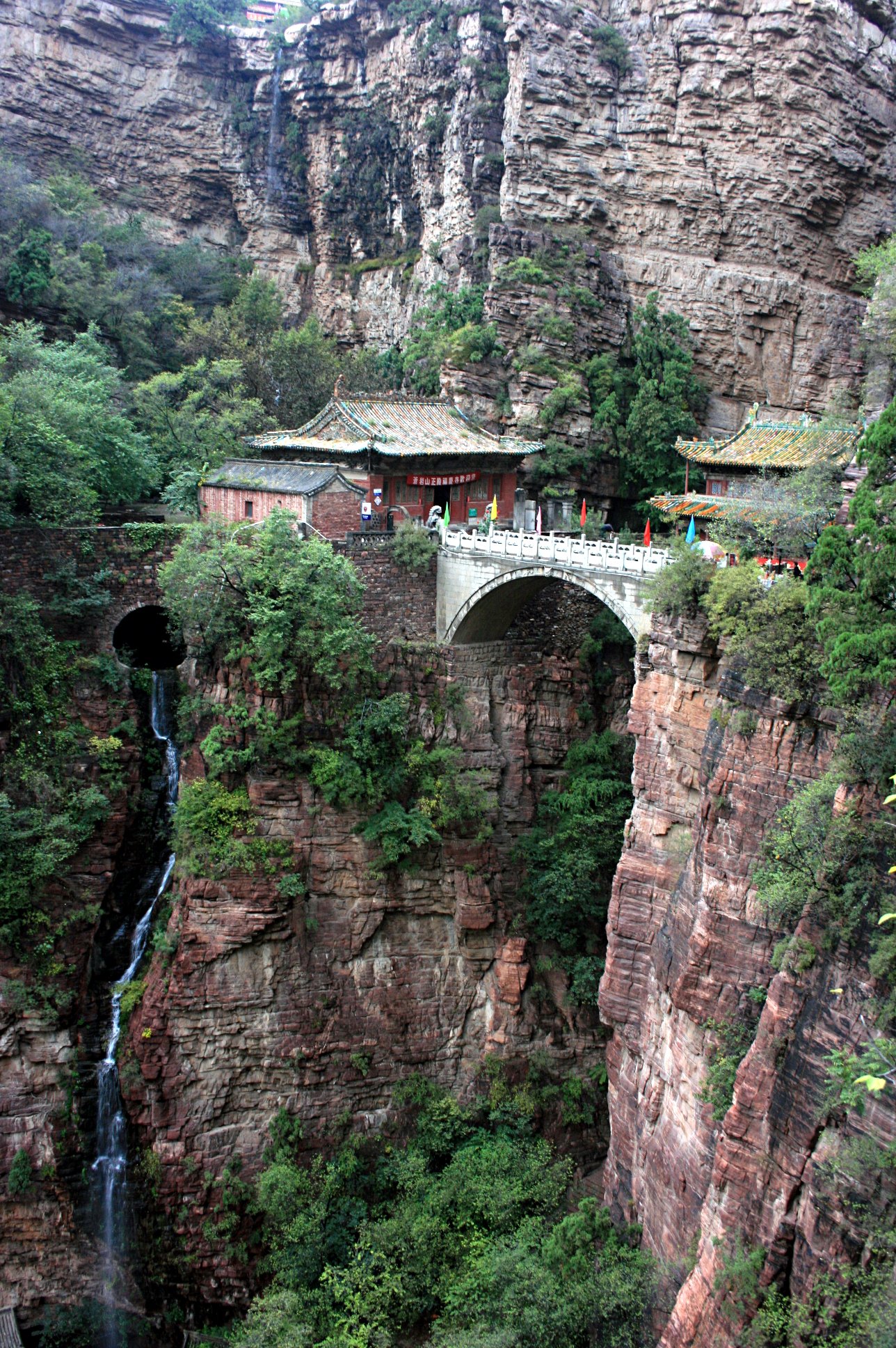
The route climbs from the scenic-area entrance through the main temple and cliff architecture zone to Fuqing Temple and the Bridge Tower Hall, then continues to stair and viewpoint sections such as Sky Ladder / viewing platforms where open. CNTravelNav describes a classic half-day route from the main gate to Fuyan/Fuqing temple areas, Bridge-Crossing Hall, Sky Ladder, and viewing platform.
Why it is essential
Cangyan Mountain is the central Hebei Taihang’s most distinctive culture-and-cliff hike, centred on the temple bridge spanning a ravine between rock walls.
Equipment
Standard hiking equipment: grippy shoes, rain layer, water, sun protection, and a warm layer outside summer.
Hazards and notes
Steep stone steps, wet/icy paving, cliff edges, crowds, and managed scenic-area opening hours are the key issues. Exact walking statistics need GPS verification.
GPX / KML links
| Source | URL | Format / access | Reuse status |
|---|---|---|---|
| OpenStreetMap search: Cangyan Mountain | openstreetmap.org | Map/search | OSM data is ODbL; geometry cross-check only |
| CNTravelNav: Cangyan Mountain route | cntravelnav.com | Guide route | Site terms apply; no route-file licence found; itinerary reference only |
External links
- LoongWander — Cangyan Mountain Scenic Area
- CNTravelNav — Cangyan Mountain Scenic Area
- BH2255 — Cangyan Mountain scenic-area guide
2. Zhangshiyan Cliff and Huang’annao Route
Snapshot
Itinerary
The route should follow the main signed Zhangshiyan Scenic Area paths through red sandstone cliff and valley scenery, with a high-point or viewpoint objective towards Huang’annao if open. LoongWander identifies Zhangshiyan as a national scenic spot, national geopark, and 4A attraction with altitudes from about 1,000 to 1,700 m and Huang’annao at 1,774 m.
Why it is essential
Zhangshiyan is central Hebei’s type locality for the Zhangshiyan sandstone landform, one of China’s recognised major sandstone landscapes.
Equipment
Mountain hiking equipment: sturdy shoes, rain/wind layer, water, food, sun protection, and navigation.
Hazards and notes
Exact trail geometry and official route statistics were not found. Use the current scenic-area map, obey closures, and avoid cliff-edge side paths in rain, fog, or ice.
GPX / KML links
| Source | URL | Format / access | Reuse status |
|---|---|---|---|
| OpenStreetMap search: Zhangshiyan | openstreetmap.org | Map/search | OSM data is ODbL; geometry cross-check only |
| BH2255: Zhangshiyan guide | bh2255.com | Guide page | Site terms apply; no route-file licence found; attraction reference only |
External links
- LoongWander — Zhangshiyan Scenic Area
- Visit Beijing — Zhang Shiyan Taihang scenery
- ChinaTourStar — Zhangshiyan Scenic Area
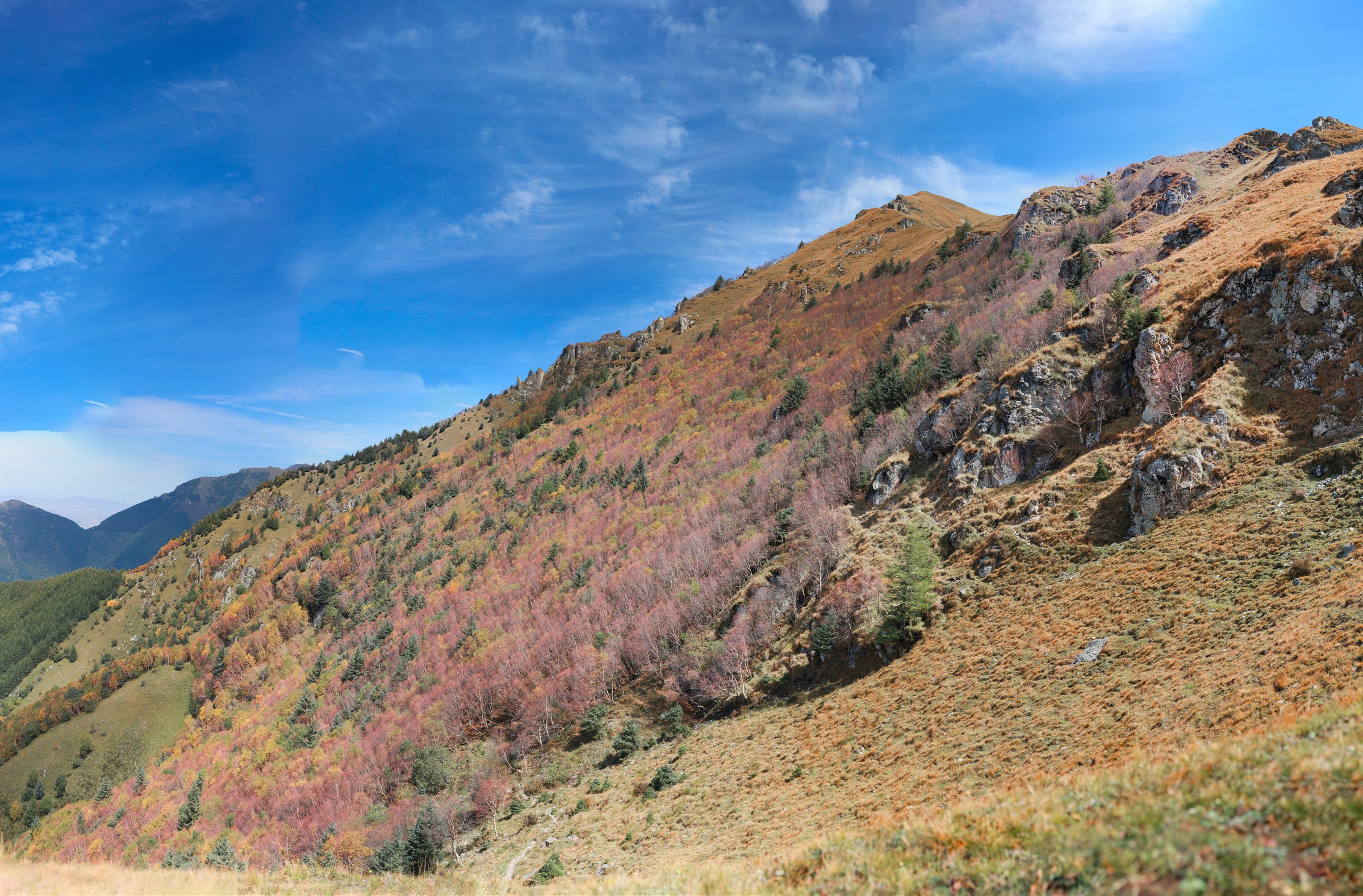
3. Tuoliang Mountain Main Peak

Snapshot
Itinerary
The route climbs through the Tuoliang Scenic Area’s forest and stream landscape towards the hump-shaped main peak at 2,281 m. Visit Beijing and Shijiazhuang government sources identify Tuoliang as one of Hebei’s five highest mountains, with intact forest and a relatively even high summit area.
Why it is essential
Tuoliang supplies the entry’s high mountain summit route and one of the major 2,000 m objectives in the central Hebei Taihang.
Equipment
Mountain hiking equipment: sturdy boots, warm layer, waterproof/windproof layer, water, food, sun protection, map/GPS backup, and poles.
Hazards and notes
High-elevation weather, fog, slippery stream/forest paths, and long road access are the main issues. Official route distance and gain need GPS verification.
GPX / KML links
| Source | URL | Format / access | Reuse status |
|---|---|---|---|
| OpenStreetMap search: Tuoliang Mountain | openstreetmap.org | Map/search | OSM data is ODbL; geometry cross-check only |
| Shijiazhuang government: Tuoliang Mountain | sjz.gov.cn | Official attraction page | Site terms apply; no route-file licence found; access/landmark reference only |
External links
- Shijiazhuang government — Tuoliang Mountain
- Visit Beijing — Tuoliang Mountain in Hebei
- LoongWander — Tuoliang Scenic Area
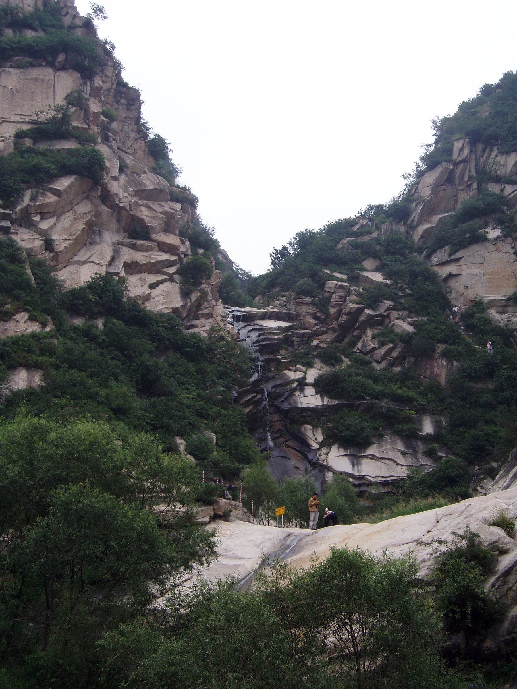
4. Wuyuezhai: Yinhe Gorge and Wuyue Peaks
Snapshot
Itinerary
The route combines the lower Yinhe Gorge waterfall section with the Wuyue Peaks and, where practical, the high meadow/forest summit area. LoongWander describes a one-day tour starting with Yinhe Gorge attractions such as Yanzhao First Waterfall, Tongyue Gorge, and Guanyin Cave, then continuing to the Wuyue Peaks and main peak area.
Why it is essential
Wuyuezhai is one of the major forest, waterfall, and high-ridge walking areas in the central Hebei Taihang, and it also links conceptually with the nearby Tuoliang high ridge.
Equipment
Mountain hiking equipment: sturdy shoes or boots, rain layer, warm layer, water, food, sun protection, navigation backup, and poles.
Hazards and notes
Waterfall/gorge paths can be slippery, and the high route can be foggy or cold. LoongWander notes a 5 km ridge line from Wuyuezhai’s main peak towards Tuoliang, but this should not be assumed open or suitable without current local confirmation.
GPX / KML links
| Source | URL | Format / access | Reuse status |
|---|---|---|---|
| OpenStreetMap search: Wuyuezhai | openstreetmap.org | Map/search | OSM data is ODbL; geometry cross-check only |
| LoongWander: Wuyuezhai Scenic Area | loongwander.com | Guide itinerary | Site terms apply; no route-file licence found; itinerary and elevation reference only |
External links
5. Tiangui Mountain Daoist Peak Circuit
Snapshot
Itinerary
The route should follow the main signed Tiangui Mountain scenic paths linking Daoist temples, strange rocks, caves, valleys, and peak/viewpoint sections such as Sanqing Peak and Wanghai Peak where open. China Daily and Shijiazhuang government sources identify Tiangui Mountain as a Daoist mountain area of about 60 sq km, roughly 80-90 km from Shijiazhuang.
Why it is essential
Tiangui Mountain adds the central Taihang’s Daoist mountain tradition and cave/temple landscape to the selection.
Equipment
Standard hiking equipment: hiking shoes, water, snacks, sun protection, and weather layer. Use poles if many stair descents are planned.
Hazards and notes
Route statistics and high point remain unresolved. Use current scenic-area maps and avoid closed cave/cliff sections.
GPX / KML links
| Source | URL | Format / access | Reuse status |
|---|---|---|---|
| OpenStreetMap search: Tiangui Mountain | openstreetmap.org | Map/search | OSM data is ODbL; geometry cross-check only |
| China Daily: Tiangui Mountain | chinadaily.com.cn | Attraction page | Site terms apply; no route-file licence found; landmark reference only |
External links
- China Daily — Tiangui Mountain
- Shijiazhuang government — Tiangui Mountain
- Trip.com — Tiangui Mountain route/attraction notes
External links
| Source | URL |
|---|---|
| LoongWander — Cangyan Mountain | loongwander.com |
| LoongWander — Zhangshiyan | loongwander.com |
| LoongWander — Tuoliang | loongwander.com |
| LoongWander — Wuyuezhai | loongwander.com |
| Shijiazhuang government — Tuoliang Mountain | sjz.gov.cn |
| Shijiazhuang government — Tiangui Mountain | sjz.gov.cn |
| China Daily — Tiangui Mountain | chinadaily.com.cn |
| Visit Beijing — Zhang Shiyan | english.visitbeijing.com.cn |
| Visit Beijing — Tuoliang Mountain | english.visitbeijing.com.cn |
| CNTravelNav — Cangyan Mountain | cntravelnav.com |
| CNTravelNav — Wuyuezhai | cntravelnav.com |
| BH2255 — Cangyan Mountain | bh2255.com |
| BH2255 — Zhangshiyan | bh2255.com |
| Trip.com — Tiangui Mountain | trip.com |