Regional overview
The Beijing-Hebei northern Taihang region covers the western mountain edge of Beijing and the high ridges running into northern Hebei. The walking character is mixed: ticketed scenic-area stair routes, old trade and pilgrimage roads, forested limestone ridges, high meadows above 2,000 m, and long local hiking traverses used by Beijing outdoor groups.
This entry avoids Great Wall routes in the Yanshan Mountains and focuses on the western Beijing / northern Taihang extension: Dongling/Lingshan, Baihua Mountain, the Jiufeng-Yangtai-Miaofeng ridge, Jingxi Ancient Road, and Qianling Mountain. Mount Xiaowutai, the highest Taihang summit, is noted as important but not selected as a clean ordinary day-hike in this pass because current access and nature-reserve restrictions need local confirmation.
The normal hiking season is spring to autumn. High routes such as Dongling and Baihua can have lingering snow, strong wind, fog, and sudden cold. Summer storms, muddy unmarked side trails, and transport uncertainty at remote trailheads are common planning issues.
Selection rationale
The five hikes below represent the region’s main day-walking types: Beijing’s highest mountain trail, a high-flower meadow scenic route, a major west-Beijing ridge traverse, a historic trade-road walk, and a shorter temple/cave mountain loop. Route statistics are strongest for the AllTrails mapped routes; Dongling/Lingshan and Jingxi Ancient Road rely on official tourism and reputable hiking-source figures.
Summary table
| # | Hike | Country | Route type | Distance | Gain | Max elevation | Difficulty | Photo status |
|---|---|---|---|---|---|---|---|---|
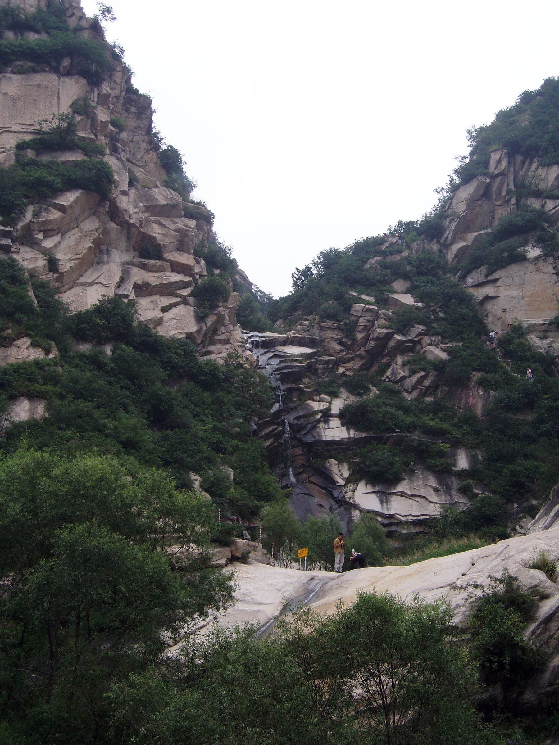
| 1 | Dongling Mountain via Lingshan Ancient Trail | China | Out-and-back | Approx. 16 km return if using the 8 km ascent route | Approx. 900-1,100 m | 2,303 m | Hard | Commons regional image verified |
| 2 | Baihua Mountain Natural Scenic Area | China | Out-and-back | 4.3 km | 217 m | 1,989-2,049 m depending source/variant | Moderate | Commons image verified |
| 3 | Mount Jiufeng, Mount Yangtai and Mount Miaofeng Loop | China | Loop | 21.6 km | 1,796 m | 1,279 m on AllTrails route | Hard | Commons category found |
| 4 | Jingxi Ancient Road / Niujiaoling section | China | Loop / lollipop | Approx. 10-12 km | Moderate | Commons regional image verified | ||
| 5 | Qianling Mountain Loop | China | Loop | 6.9 km | 473 m | 624-699 m depending source | Hard | Commons category found |
1. Dongling Mountain via Lingshan Ancient Trail
Snapshot
Itinerary
The route follows the reopened Juling Gorge / Lingshan Ancient Trail towards Dongling Mountain, Beijing’s highest summit. Beijing government tourism material describes an 8 km ancient trail leading directly to the summit at 2,303 m, with alpine meadow scenery and mountain springs. The walking is a sustained climb from the valley-side scenic area to the high open ridge, then returns by the same line unless a local traverse has been arranged.
Why it is essential
Dongling Mountain is the highest summit in Beijing and the clearest high-mountain day objective in the northern Taihang extension near the capital.
Equipment
Mountain hiking equipment: sturdy boots, windproof/waterproof layer, warm layer, food, 2 litres of water, sun protection, navigation backup, and trekking poles. Carry hat/gloves outside midsummer.
Hazards and notes
High wind, fog, snow, muddy side trails, and remote transport are the main issues. Check current scenic-area opening and trail status before travel. Mount Xiaowutai remains a higher Taihang objective nearby, but protected-area access was not sufficiently verified for catalogue inclusion.
Photos
| Image | Source | Author | Licence | Reuse notes | Attribution |
|---|---|---|---|---|---|
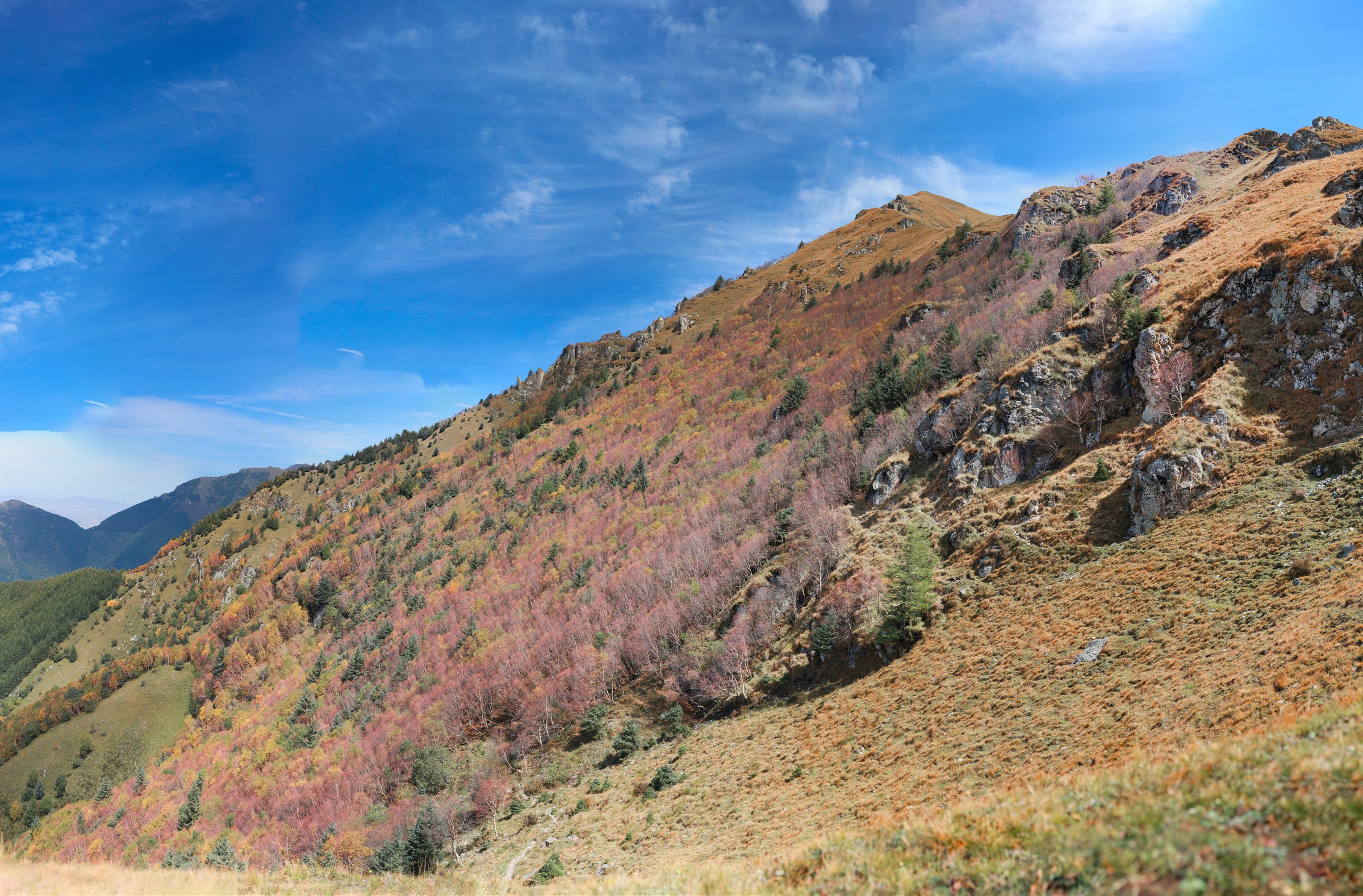
| Autumn landscape in Xitai Mountain of Xiaowutai Mountain | commons.wikimedia.org | Sun Jiao / Interaccoonale | CC BY-SA 4.0 | Regional northern Taihang image; commercial reuse and modification appear allowed with attribution and share-alike | “Autumn landscape in Xitai Mountain of Xiaowutai Mountain” by Sun Jiao, CC BY-SA 4.0, via Wikimedia Commons |
GPX / KML links
| Source | URL | Format | Licence / terms | Reuse status |
|---|---|---|---|---|
| OpenStreetMap search: Dongling Mountain / Lingshan | openstreetmap.org | Map/search | OSM data is ODbL | Geometry cross-check only |
| Official Beijing tourism note | english.beijing.gov.cn | Official route description | Site terms apply | Confirms 8 km trail and 2,303 m summit; no GPX found |
External links
- Beijing Municipal Government — high-mountain meadows / Lingshan Ancient Trail
- Visit Beijing — Dongling Mountain
- Visit Beijing — Lingshan Mountain
2. Baihua Mountain Natural Scenic Area
Snapshot
Itinerary
The mapped route climbs through the Baihua Mountain scenic area to the high meadow and viewpoint zone. Official Beijing sources describe Baihua Mountain as a cool summer retreat in Qingshui Town, Mentougou, with Baicaopan Peak rising to 2,049 m and extensive alpine meadow flowers in early summer.
Why it is essential
Baihua Mountain is one of Beijing’s best-known high-flower meadow hikes and provides a gentler counterpart to Dongling Mountain.
Equipment
Standard hiking equipment: hiking shoes, rain/wind layer, warm layer, water, snacks, sun protection, and navigation. Trekking poles are useful if descending wet steps.
Hazards and notes
Expect crowds during flower season and holidays. Stone and soil paths can be slippery after rain. Confirm whether the exact meadow and peak paths are open before relying on the AllTrails line.
Photos
| Image | Source | Author | Licence | Reuse notes | Attribution |
|---|---|---|---|---|---|
| Baihuashan mts IMG 4184 Fangshan, Beijing | commons.wikimedia.org | Bjoertvedt | CC BY-SA 4.0 | Commercial reuse and modification appear allowed with attribution and share-alike | “Baihuashan mts IMG 4184 Fangshan, Beijing” by Bjoertvedt, CC BY-SA 4.0, via Wikimedia Commons |
GPX / KML links
| Source | URL | Format | Licence / terms | Reuse status |
|---|---|---|---|---|
| AllTrails: Baihua Mountain Natural Scenic Area | alltrails.com | Route page / app map | AllTrails terms apply; GPX export terms not verified | Source-map and statistics used; file reuse not confirmed |
| OpenStreetMap search: Baihua Mountain | openstreetmap.org | Map/search | OSM data is ODbL | Geometry cross-check only |
External links
- AllTrails — Baihua Mountain Natural Scenic Area
- Beijing Municipal Government — Baihua Mountain
- TravelChinaGuide — Baihua Mountain
3. Mount Jiufeng, Mount Yangtai and Mount Miaofeng Loop
Snapshot
Itinerary
The loop climbs from Dajue Temple through Jiufeng, continues over Yangtai Mountain, and reaches the Miaofeng Mountain temple area before returning. AllTrails describes forested stone steps, unpaved ridge sections, views back over Beijing, and the Huiji Goddess Temple complex on Miaofeng.
Why it is essential
This is the strongest long ridge day in the western Beijing Taihang extension, linking three named mountains and an old pilgrimage destination.
Equipment
Mountain hiking equipment: boots or grippy shoes, 2-3 litres of water, food, rain/wind layer, warm layer, sun protection, headtorch, and navigation backup.
Hazards and notes
The route is long and steep, with almost 1,800 m of cumulative ascent. Do not start late. Summer heat and thunderstorms can be serious; winter ice can make stone steps hazardous.
Photos
| Image | Source | Author | Licence | Reuse notes | Attribution |
|---|---|---|---|---|---|
| Category:Jiufeng | commons.wikimedia.org | Unresolved | Per-file licences vary | Category found for follow-up; no individual image selected in this pass | Unresolved |
| Category:Miaofengshan | commons.wikimedia.org | Unresolved | Per-file licences vary | Category found for follow-up; no individual image selected in this pass | Unresolved |
GPX / KML links
| Source | URL | Format | Licence / terms | Reuse status |
|---|---|---|---|---|
| AllTrails: Mount Jiufeng, Mount Yangtai and Mount Miaofeng Loop | alltrails.com | Route page / app map | AllTrails terms apply; GPX export terms not verified | Source-map and statistics used; file reuse not confirmed |
| OpenStreetMap search: Miaofeng Mountain | openstreetmap.org | Map/search | OSM data is ODbL | Geometry cross-check only |
External links
- AllTrails — Mount Jiufeng, Mount Yangtai and Mount Miaofeng Loop
- Visit Beijing — Yangtai Mountain to Miaofeng Mountain route context
- Visit Beijing — Beijing mountain hiking guide
4. Jingxi Ancient Road / Niujiaoling Section
Snapshot
Itinerary
This route follows a preserved section of the Jingxi Ancient Road, the historic network of trade, military, and pilgrimage routes through the mountains west of Beijing. Beijing government material identifies the Niujiaoling section as a well-preserved relic with stone horse-hoof prints, while Beijing Hikers describes a 10-12 km loop-style hike through old road sections, village terrain, forest, and optional steeper ground.
Why it is essential
The Jingxi Ancient Road adds the region’s strongest cultural walking element: old caravan routes, stone paving, passes, temples, and mountain villages rather than only summit routes.
Equipment
Standard hiking equipment: hiking shoes, water, food, sun protection, weather layer, and navigation. Gloves may help if using the steeper chain-assisted option.
Hazards and notes
Route variants vary widely. Some side trails are rough or unsigned. Avoid wet stone if taking steeper options. Use current local route notes rather than assuming every old-road segment is open.
Photos
| Image | Source | Author | Licence | Reuse notes | Attribution |
|---|---|---|---|---|---|
| Baihuashan mts IMG 4184 Fangshan, Beijing | commons.wikimedia.org | Bjoertvedt | CC BY-SA 4.0 | Regional western Beijing mountain image; not specific to Jingxi Ancient Road | “Baihuashan mts IMG 4184 Fangshan, Beijing” by Bjoertvedt, CC BY-SA 4.0, via Wikimedia Commons |
GPX / KML links
| Source | URL | Format | Licence / terms | Reuse status |
|---|---|---|---|---|
| Beijing Hikers: Jingxi Ancient Road hike | beijinghikers.com | Hiking route page | Site terms apply; no route-file licence found | Route statistics and itinerary reference only |
| OpenStreetMap search: Jingxi Ancient Road | openstreetmap.org | Map/search | OSM data is ODbL | Geometry cross-check only |
External links
- Beijing Hikers — Jingxi Ancient Road hike
- Beijing Municipal Government — Jingxi Ancient Road Niujiaoling section
- Beijing Municipal Government — Jingxi Ancient Road Scenic Area cycling route note
5. Qianling Mountain Loop
Snapshot
Itinerary
The loop climbs through Qianling Mountain Park, linking peak viewpoints, cave/grotto areas, and stone-step trail sections. Beijing government material identifies Qianling Mountain as part of the Ma’anshan Mountains, with Jile Peak at 699 m and a large grotto temple compound.
Why it is essential
Qianling gives the entry a shorter but still steep mountain loop with cultural cave/temple features close to Beijing, suitable when the higher Mentougou routes are impractical.
Equipment
Standard hiking equipment: grippy shoes, water, sun protection, weather layer, and navigation. Poles are useful for stair descents if permitted.
Hazards and notes
Stone steps can be slippery in rain or ice. The route is in a managed park with opening hours and possible cableway operations; confirm current entry rules.
Photos
| Image | Source | Author | Licence | Reuse notes | Attribution |
|---|---|---|---|---|---|
| Category:Qianling Mountain, Beijing | commons.wikimedia.org | Unresolved | Per-file licences vary | Category found for follow-up; no individual image selected in this pass | Unresolved |
GPX / KML links
| Source | URL | Format | Licence / terms | Reuse status |
|---|---|---|---|---|
| AllTrails: Qianling Mountain Loop | alltrails.com | Route page / app map | AllTrails terms apply; GPX export terms not verified | Source-map and statistics used; file reuse not confirmed |
| OpenStreetMap search: Qianling Mountain Beijing | openstreetmap.org | Map/search | OSM data is ODbL | Geometry cross-check only |
External links
- AllTrails — Qianling Mountain Loop
- Beijing Municipal Government — Qianling Mountain Park
- Visit Beijing — Qianling Mountain
External links
| Source | URL |
|---|---|
| Beijing Municipal Government — high-mountain meadows / Lingshan Ancient Trail | english.beijing.gov.cn |
| Beijing Municipal Government — Jingxi Ancient Road Scenic Area cycling route note | english.beijing.gov.cn |
| Beijing Municipal Government — Qianling Mountain Park | english.beijing.gov.cn |
| Beijing Municipal Government — Jingxi Ancient Road Niujiaoling section | english.visitbeijing.com.cn |
| Visit Beijing — Dongling Mountain | english.visitbeijing.com.cn |
| Visit Beijing — Lingshan Mountain | english.visitbeijing.com.cn |
| Visit Beijing — Yangtai Mountain to Miaofeng Mountain route context | english.visitbeijing.com.cn |
| Visit Beijing — Beijing mountain hiking guide | english.visitbeijing.com.cn |
| Visit Beijing — Qianling Mountain | english.visitbeijing.com.cn |
| TravelChinaGuide — Baihua Mountain | travelchinaguide.com |
| Beijing Hikers — Jingxi Ancient Road hike | beijinghikers.com |
| AllTrails — Baihua Mountain Natural Scenic Area | alltrails.com |
| AllTrails — Mount Jiufeng, Mount Yangtai and Mount Miaofeng Loop | alltrails.com |
| AllTrails — Qianling Mountain Loop | alltrails.com |