Regional overview
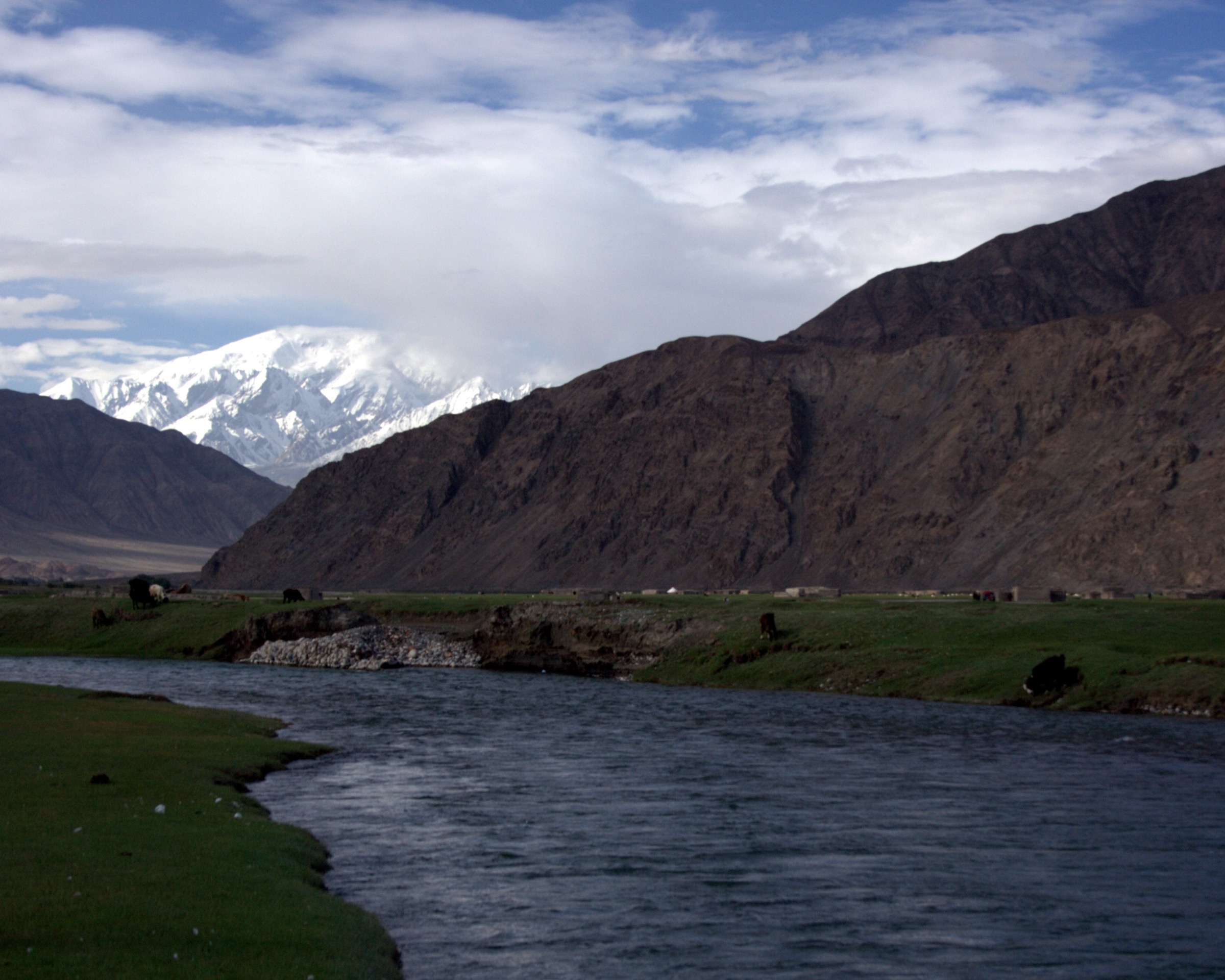
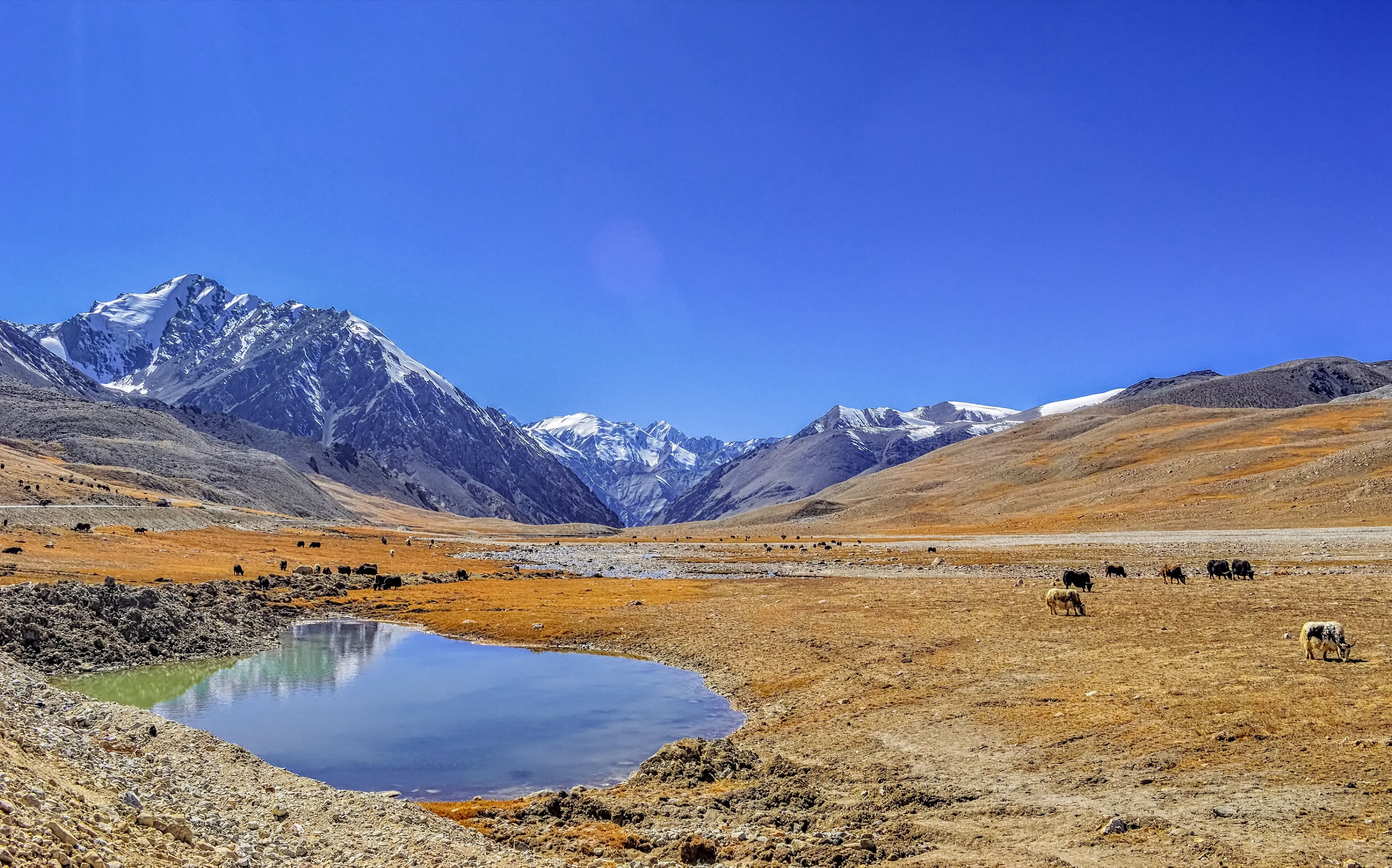
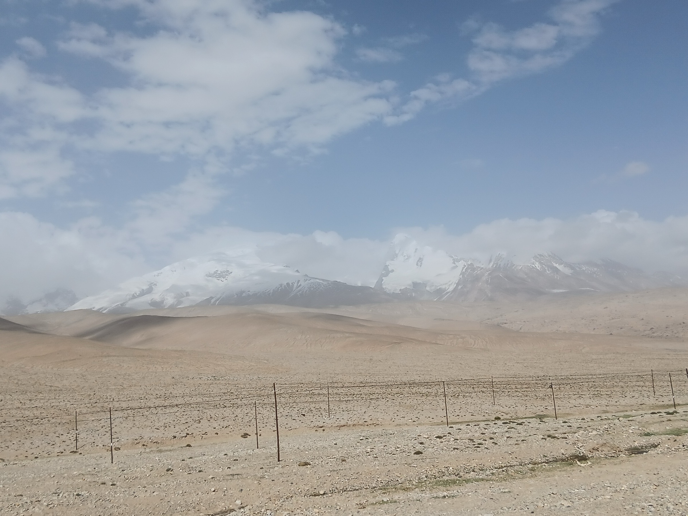
Karakul Lake and Muztagh Ata form the classic high-Pamir landscape on the Kashgar-Tashkurgan section of the Karakoram Highway: a 3,600 m lake, Kyrgyz yurt meadows, the rounded ice dome of Muztagh Ata, views to Kongur and Kongur Tiube, and high glacial valleys around Subashi and the Muztagh Ata glacier parks. The walking is visually spectacular but logistically controlled.
This region overlaps border-control and high-altitude mountain-management zones. Karakul Lake, Tashkurgan, and the Pamir Plateau commonly require frontier-area permission for travellers, and the Akto County Culture and Tourism Bureau published a 2025 notice prohibiting unauthorised hiking, climbing, camping, and access to unopened areas during the closure season to 10 June 2026, including private ascent of Muztagh Ata and trips to climbing base camp / No. 2-3 glacier areas. Muztagh Ata Glacier Park No. 4 is a managed scenic-area visit with shuttle and steps rather than a free wilderness trail.
The normal walking season is late spring to autumn, but snow, wind, intense UV, low oxygen, and access controls are central considerations. The five routes below separate developed scenic-area walks from candidate mountain approaches that require current local permission.
Selection rationale
The selection balances the lake, the glacier-park experience, Subashi’s three-peak panorama, Baisha / White Sand Lake on the Karakul approach, and the famous but access-sensitive Muztagh Ata base-camp approach. The base-camp route is included as a candidate only because current official access restrictions and route-file evidence are incomplete.
Summary table
| # | Hike | Country | Route type | Distance | Gain | Max elevation | Difficulty |
|---|---|---|---|---|---|---|---|
| 1 | Karakul Lake Shore and Kyrgyz Meadow Walk | China | Loop / out-and-back shore walk | ca. 5–10 km depending legal lakeshore section | Minor | ca. 3,600 m | Easy–moderate at altitude |
| 2 | Subashi Three-Peaks Viewpoint Walk | China | Out-and-back viewpoint walk | ca. 2–4 km | Minor | ca. 3,800–3,900 m | Easy–moderate |
| 3 | Muztagh Ata Glacier Park No. 4 Official Glacier-View Walk | China | Shuttle-assisted out-and-back | ca. 1.5 km walking plus shuttle | Several hundred steps; exact gain unresolved | ca. 4,800–5,000 m | Moderate–hard at altitude |
| 4 | Muztagh Ata Base-Camp Approach from Subashi | China | Out-and-back mountain approach | ca. 12–18 km; route variant unresolved | ca. 600–900 m | ca. 4,400–4,500 m | Hard |
| 5 | Baisha Mountain / White Sand Lake Shore View Walk | China | Short out-and-back / shore walk | ca. 2–5 km | Minor | ca. 3,300–3,500 m | Easy–moderate |
1. Karakul Lake Shore and Kyrgyz Meadow Walk

Snapshot
Itinerary
The walk follows legal lakeshore paths, meadows, and visitor-access areas around Karakul Lake. On calm days, the route gives reflections of Muztagh Ata and Kongur; short detours to Kyrgyz yurt areas may be possible where permitted and welcomed locally.
The China Dragon Travel Karakul guide verifies the lake’s altitude around 3,600 m, its position about 200 km southwest of Kashgar on the Karakoram Highway, and the existence of short hiking routes around the lake. A precise official pedestrian circuit and GPX were not found.
Why it is essential
Karakul Lake is the region’s iconic low-gradient walk: high-altitude water, yurt meadows, and the classic Muztagh Ata reflection.
Equipment
- Walking shoes
- Windproof / warm layer
- Sun hat and sunglasses
- Sunscreen
- Water and snacks
- Slow pacing for altitude
Hazards and notes
- Altitude is significant despite the easy terrain
- Do not wander into private grazing areas or fragile lakeshore
- Border-area permits and current scenic-area ticketing should be confirmed before travel
GPX / KML links
| Source | URL | Format / access | Reuse status |
|---|---|---|---|
| OpenStreetMap search: Karakul Lake Xinjiang | openstreetmap.org | Source map | OSM data is ODbL; geometry cross-check only |
| China Dragon Travel: Karakul Lake guide | chinadragontravel.com | Source page / access notes | Site terms apply; no route-file licence found |
External links
2. Subashi Three-Peaks Viewpoint Walk
Snapshot
Itinerary
From the Subashi service area or a legal viewpoint stop, the walk uses open, non-sensitive ground and signed/accepted pedestrian space to view Muztagh Ata, Kongur Peak, and Kongur Jiubie / Kongur Tiube in one broad panorama. The route should remain close to legal parking and viewpoint areas unless a local guide confirms a permitted path.
The source verifies Subashi as a key free viewpoint on the Muztagh Ata route, but no official trail statistics or GPX were found.
Why it is essential
Subashi gives one of the broadest and most accessible summit panoramas in the Karakul–Muztagh Ata region, balancing the lakeshore walk with a drier high-plateau viewpoint.
Equipment
- Sturdy shoes
- Windproof layer
- Warm layer
- Water
- Sun protection and sunglasses
- Navigation backup if walking away from the parking area
Hazards and notes
- Altitude and cold wind
- Unmarked vehicle tracks and permit boundaries
- Do not enter closed glacier, base-camp, or mountain zones from Subashi without current official permission and a local guide
GPX / KML links
| Source | URL | Format / access | Reuse status |
|---|---|---|---|
| OpenStreetMap search: Subashi Muztagh Ata | openstreetmap.org | Source map | OSM data is ODbL; landmark cross-check only |
| China Dragon Travel: Muztagh Ata guide | chinadragontravel.com | Travel guide / access notes | Site terms apply; no route-file licence found |
External links
- China Dragon Travel — Muztagh Ata guide
- Akto County 2025 notice on unauthorised hiking and closed areas
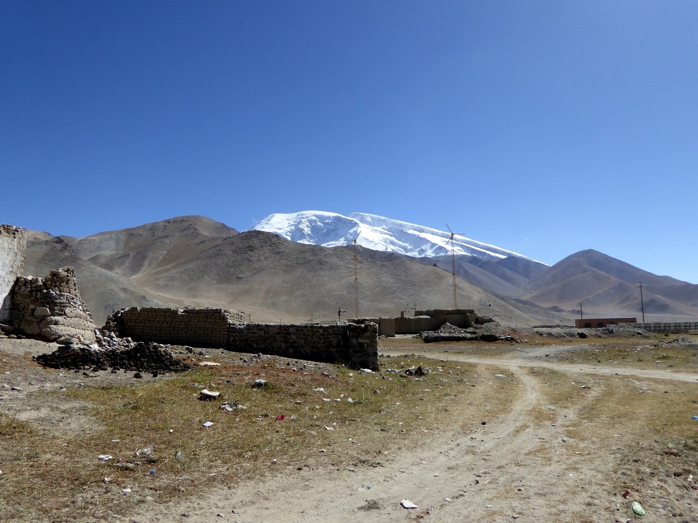
3. Muztagh Ata Glacier Park No. 4 Official Glacier-View Walk
Snapshot
Itinerary
The official visitor route enters Muztagh Ata Glacier Park, uses the internal shuttle for the long approach from the gate, and then continues on foot via several hundred steps / constructed path to the No. 4 Glacier viewing area. Local news reporting describes the gate area around 4,000 m, shuttle transfer of more than 10 km, and a final stepped climb to the glacier front area; other route notes cite about 1.5 km of walking.
The route is high and slow despite the short distance. It is not a mountaineering route to Muztagh Ata and does not require walking onto unprotected glacier ice.
Why it is essential
This is the principal public glacier-view walk in the Muztagh Ata area, allowing fit visitors to approach the “Father of Ice Mountains” without joining an expedition.
Equipment
- Warm layers
- Windproof shell
- Sturdy shoes
- Sunglasses and sun protection
- Water and snacks
- Gloves and hat outside midsummer
- Microspikes only for icy official-path conditions if locally advised
Hazards and notes
- Altitude near 5,000 m is the major hazard; move slowly and turn back for headache, nausea, dizziness, or breathlessness
- Stay on the official path; local signage warns not to leave the walkway
- Protect the fragile high-altitude environment
GPX / KML links
| Source | URL | Format / access | Reuse status |
|---|---|---|---|
| OpenStreetMap search: Muztagh Ata Glacier Park | openstreetmap.org | Source map | OSM data is ODbL; landmark cross-check only |
| China News Xinjiang: Muztagh Ata Glacier Park report | xj.chinanews.com.cn | Local news / access report | Site terms apply; no route-file licence found |
External links
- China News Xinjiang — Muztagh Ata Glacier Park report
- China Dragon Travel — Muztagh Ata guide
- Akto County 2025 notice on unauthorised hiking and closed areas
4. Muztagh Ata Base-Camp Approach from Subashi
Snapshot
Itinerary
The classic non-technical approach to Muztagh Ata expedition base camp is usually described from the Subashi side across high desert and moraine terrain. It is included here only as a candidate because it is historically central to the mountain and potentially day-scale for acclimatised walkers, but current official access, legal trailhead, distance, and route-file status are unresolved.
As of the Akto County 2025 notice covering the closure season to 10 June 2026, private climbing of Muztagh Ata and tourist travel to the climbing base camp / No. 2–3 glacier areas were prohibited. Future access must be checked directly with local authorities and licensed operators.
Why it is essential
Muztagh Ata is the signature summit of the region. A legal base-camp approach would be the essential mountain walk, but it is not ready for publication as an open day hike without stronger current access evidence.
Equipment
- Sturdy boots
- Trekking poles
- Warm / windproof layers
- Sun protection and sunglasses
- Water and food
- Headtorch
- Navigation backup
- Emergency warm layer
- Local guide required if authorities permit access; technical glacier equipment not implied for the non-glacier approach
Hazards and notes
- Altitude, remoteness, cold wind, and poor vehicle tracks
- Lack of rescue
- Permit restrictions and possible legal closure
- Do not attempt this route independently or during a closure period
GPX / KML links
| Source | URL | Format / access | Reuse status |
|---|---|---|---|
| OpenStreetMap search: Muztagh Ata Base Camp Subashi | openstreetmap.org | Source map | OSM data is ODbL; landmark cross-check only |
| SummitPost: Muztagh Ata | summitpost.org | Mountaineering / access overview | Site terms apply; no route-file licence found |
External links
- SummitPost — Muztagh Ata overview
- China Dragon Travel — Muztagh Ata guide
- Akto County 2025 notice on unauthorised hiking and closed areas
5. Baisha Mountain / White Sand Lake Shore View Walk
Snapshot
Itinerary
The candidate route is a short legal walk along the developed or accepted lakeshore / viewpoint area at Baisha Mountain / White Sand Lake, north of Karakul Lake on the Pamir route. The route should remain within current visitor access zones and avoid dunes, slopes, or closed lake margins where access is not signed.
Why it is essential
White Sand Lake is part of the standard Karakul–Muztagh Ata approach and adds a distinctive pale-sand, blue-water landscape before the higher lake and glacier views.
Equipment
- Walking shoes
- Windproof layer
- Sun protection and sunglasses
- Water
- Warm clothing for sudden weather changes
Hazards and notes
- Wind, sand, and altitude
- Traffic near pullouts
- Unclear legal walking boundaries
- Route statistics and official walking rules need confirmation
GPX / KML links
| Source | URL | Format / access | Reuse status |
|---|---|---|---|
| OpenStreetMap search: Baisha Mountain White Sand Lake Xinjiang | openstreetmap.org | Source map | OSM data is ODbL; landmark cross-check only |
| China Dragon Travel: Muztagh Ata guide | chinadragontravel.com | Travel guide / route notes | Site terms apply; no route-file licence found |
External links
Missing data and follow-up
- No official GPX/KML files found for any route in this pass.
- Karakul Lake exact legal lakeshore route and full-circuit status need current local confirmation.
- The Muztagh Ata base-camp approach is candidate only because current access restrictions and legal route status are unresolved.
- The Akto County closure notice should be rechecked after 10 June 2026 and before any publication/travel use.
- Exact licence-compatible photos for Subashi, No. 4 Glacier Park, and White Sand Lake remain unresolved beyond broad Karakul / Muztagh Ata images.
External links
| Source | URL |
|---|---|
| China Dragon Travel — Karakul Lake guide | chinadragontravel.com |
| China Dragon Travel — Muztagh Ata guide | chinadragontravel.com |
| China News Xinjiang — Muztagh Ata Glacier Park report | xj.chinanews.com.cn |
| Akto County 2025 notice on unauthorised hiking and closed areas | xjakt.gov.cn |
| SummitPost — Muztagh Ata overview | summitpost.org |