Regional overview
The Fen River escarpment region is the eastern face of the Luliang Mountains where the hills drop toward Taiyuan and the Fen River basin. The walking character is a compact mix of cultural mountains, grottoes, temple stairs, short forest gullies, managed scenic areas, and river-corridor walking rather than remote high-mountain trekking.
The most important access area is Taiyuan’s western and northwestern hills: Jinci and Tianlong Mountain, Longshan, Mengshan, Juewei Mountain, and the Fenhe Park corridor on the basin floor. These routes represent the historical West Mountain belt, with Buddhist and Taoist cave sites, old temples, red-leaf slopes, and the river that defines the basin edge.
Spring and autumn are the best seasons, especially October for Juewei Mountain’s red leaves. Summer heat, thunderstorms, stone steps, traffic around scenic areas, and winter ice are the main practical issues. Official GPX data was not found in this pass, so most route geometry should be treated as source-map or candidate-level.
Selection rationale
The five selected walks cover the region’s main identities: the Jinci-Tianlong Mountain cultural landscape, Longshan’s Taoist grottoes, Mengshan’s giant Buddha and forested gully, Juewei Mountain’s classic Taiyuan red-leaf climb, and the Fen River parkland below the escarpment. Fenhe Park is included as a lowland corridor walk because it anchors the escarpment to the Fen River basin and has clear trail statistics.
Summary table
| # | Hike | Country | Route type | Distance | Gain | Max elevation | Difficulty |
|---|---|---|---|---|---|---|---|
| 1 | Jinci to Tianlong Mountain / Liuzhi Valley and West Peak Grottoes | China | Scenic-area route / out-and-back candidate | Approx. 4-7 km | Moderate | ||
| 2 | Longshan Grottoes Taoist summit walk | China | Out-and-back / loop candidate | Approx. 3-5 km | Moderate | ||
| 3 | Mengshan Giant Buddha forest-gully walk | China | Out-and-back / scenic-area walk | Approx. 2-5 km | Easy-moderate | ||
| 4 | Juewei Mountain / Duofu Temple red-leaf climb | China | Out-and-back / loop candidate | Approx. 4-8 km | Moderate | ||
| 5 | Fenhe Park riverfront walk | China | Out-and-back | 6.0 km | 81 m | 789 m cited by AllTrails app | Easy |
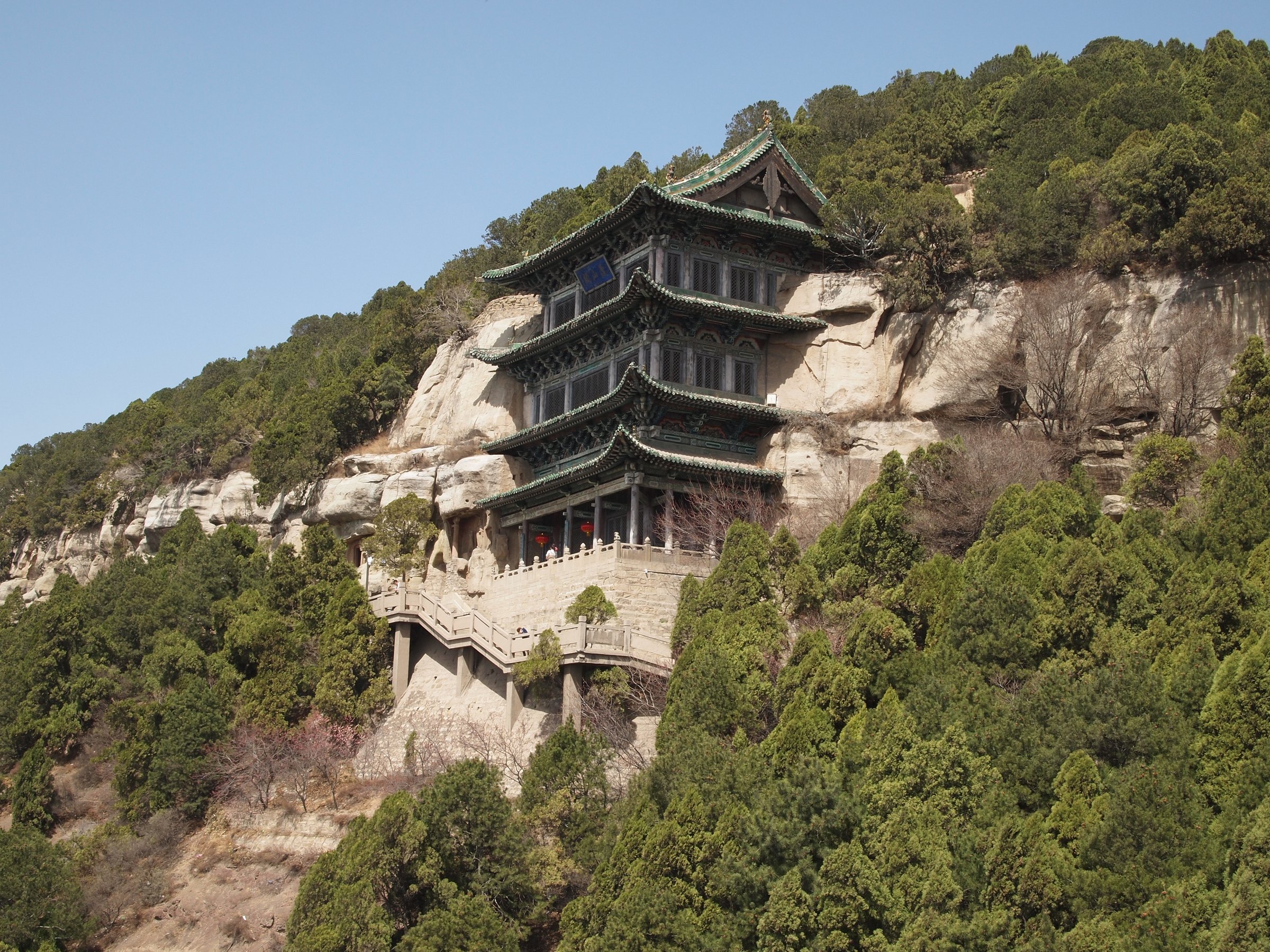
1. Jinci to Tianlong Mountain / Liuzhi Valley and West Peak Grottoes
Snapshot
Itinerary
The day-hike version links Jinci’s park and temple approach with Tianlong Mountain’s managed scenic-area route. LoongWander describes a one-day visit that includes the West Peak Grotto area, Shengshou Temple, and a hike in Liuzhi Valley to a West Peak viewing platform. The route should use the current scenic-area shuttle and permitted walking sections rather than road shortcuts.
Why it is essential
Jinci-Tianlong Mountain is the region’s strongest combination of escarpment scenery and cultural landscape. China Daily describes the scenic area as including Jinci Temple Museum, Jinci Park, Tianlong Mountain, and more than 40 scenic spots, while LoongWander identifies the grottoes as a key national cultural relics protection unit.
Equipment
Standard hiking equipment, comfortable shoes for steps and paved paths, water, sun protection, and a rain layer.
Hazards and notes
Sightseeing-bus schedules, traffic controls, tickets, stone steps, heat, and scenic-area closures should be checked before departure. Exact walking statistics remain unresolved.
GPX / KML links
| Source | URL | Format / access | Reuse status |
|---|---|---|---|
| LoongWander Tianlong Mountain route notes | loongwander.com | Guide page / itinerary | Website terms apply; no GPX licence found; route notes only |
| Official Jinci-Tianlong Mountain page | govt.chinadaily.com.cn | Source page | Website terms apply; scenic-area and access context only |
| OpenStreetMap search: Jinci Tianlong Mountain | openstreetmap.org | Source map | OSM data is ODbL; geometry cross-check only |
External links
2. Longshan Grottoes Taoist Summit Walk
Snapshot
Itinerary
The practical route climbs from the Longshan scenic-area access toward the Taoist grottoes and returns by the same managed path or current scenic-area loop. The route should remain on maintained visitor paths around the grottoes and associated temple / summit area.
Why it is essential
Longshan gives the Fen River escarpment a distinctive Taoist cultural counterpart to Tianlongshan’s Buddhist grottoes. China Daily describes Longshan Grottoes as among China’s largest and best-preserved Taoist cave shrines, while guide sources place them on Longshan Mountain southwest of Taiyuan.
Equipment
Standard hiking equipment, comfortable shoes for steps, water, sun protection, and a light rain layer.
Hazards and notes
Stone steps, summer heat, icy winter surfaces, and cultural-site closures are the main concerns. Route statistics and an official map route remain unresolved.
GPX / KML links
| Source | URL | Format / access | Reuse status |
|---|---|---|---|
| China Daily Longshan feature | shanxi.chinadaily.com.cn | Source page | Website terms apply; context only |
| China Educational Tours Longshan guide | chinaeducationaltours.com | Guide page | Website terms apply; route context only |
| OpenStreetMap search: Longshan Grottoes Taiyuan | openstreetmap.org | Source map | OSM data is ODbL; geometry cross-check only |
External links
3. Mengshan Giant Buddha Forest-Gully Walk
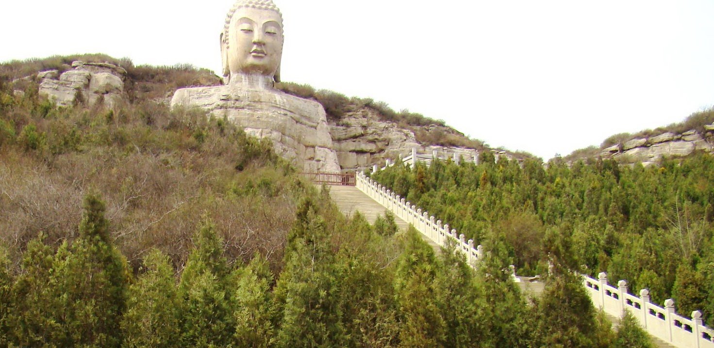
Snapshot
Itinerary
The route follows the managed Mengshan scenic-area path through the lower forested gully and temple approach to the Giant Buddha viewpoint, then returns the same way. The exact visitor path and ticketed-area route should be checked locally.
Why it is essential
Mengshan is one of Taiyuan’s major western-hill cultural landscapes. China Daily’s Shanxi site identifies the Mengshan Giant Buddha, also known as Xishan Giant Buddha, as located near Sidi village in Jinyuan district, and Wikimedia Commons lists it as a Taiyuan / Jinyuan sculpture site with a 46 m height.
Equipment
Standard hiking equipment, comfortable shoes for steps, water, sun protection, and warm clothing in winter.
Hazards and notes
Stone steps, visitor crowding, wet paving, and scenic-area closure rules are the main issues. Route statistics need a verified track or official map.
GPX / KML links
| Source | URL | Format / access | Reuse status |
|---|---|---|---|
| China Daily Shanxi Mengshan Giant Buddha page | shanxi.chinadaily.com.cn | Source page | Website terms apply; location and context only |
| Wikimedia Commons category | commons.wikimedia.org | Category / mapped site context | Commons files have individual licences; media and location context only |
| OpenStreetMap search: Mengshan Giant Buddha Taiyuan | openstreetmap.org | Source map | OSM data is ODbL; geometry cross-check only |
External links
4. Juewei Mountain / Duofu Temple Red-Leaf Climb
Snapshot
Itinerary
From Huyan Village or the current scenic-area access point, climb west into Juewei Mountain toward Duofu Temple, the stupa, and red-leaf viewpoints, then return by the same route or a permitted local loop. The route should use maintained scenic-area paths and avoid informal shortcuts on eroded slopes.
Why it is essential
Juewei Mountain is one of Taiyuan’s classic local mountain walks. BH2255 identifies “Juewei Red Leaves” as one of the eight scenic spots in Taiyuan and lists Duofu Temple, the seven-level stupa, the mountain pass, and red-leaf slopes among the main attractions.
Equipment
Standard hiking equipment, sturdy shoes, water, wind layer, sun protection, and trekking poles if descending loose or stepped paths.
Hazards and notes
Autumn crowds, stone steps, loose soil, winter ice, and path closures are the main issues. Published route statistics were not found in this pass.
GPX / KML links
| Source | URL | Format / access | Reuse status |
|---|---|---|---|
| BH2255 Juewei Mountain travel guide | bh2255.com | Guide page / scenic map reference | Website terms apply; route context only |
| OpenStreetMap search: Juewei Mountain Taiyuan | openstreetmap.org | Source map | OSM data is ODbL; geometry cross-check only |
External links
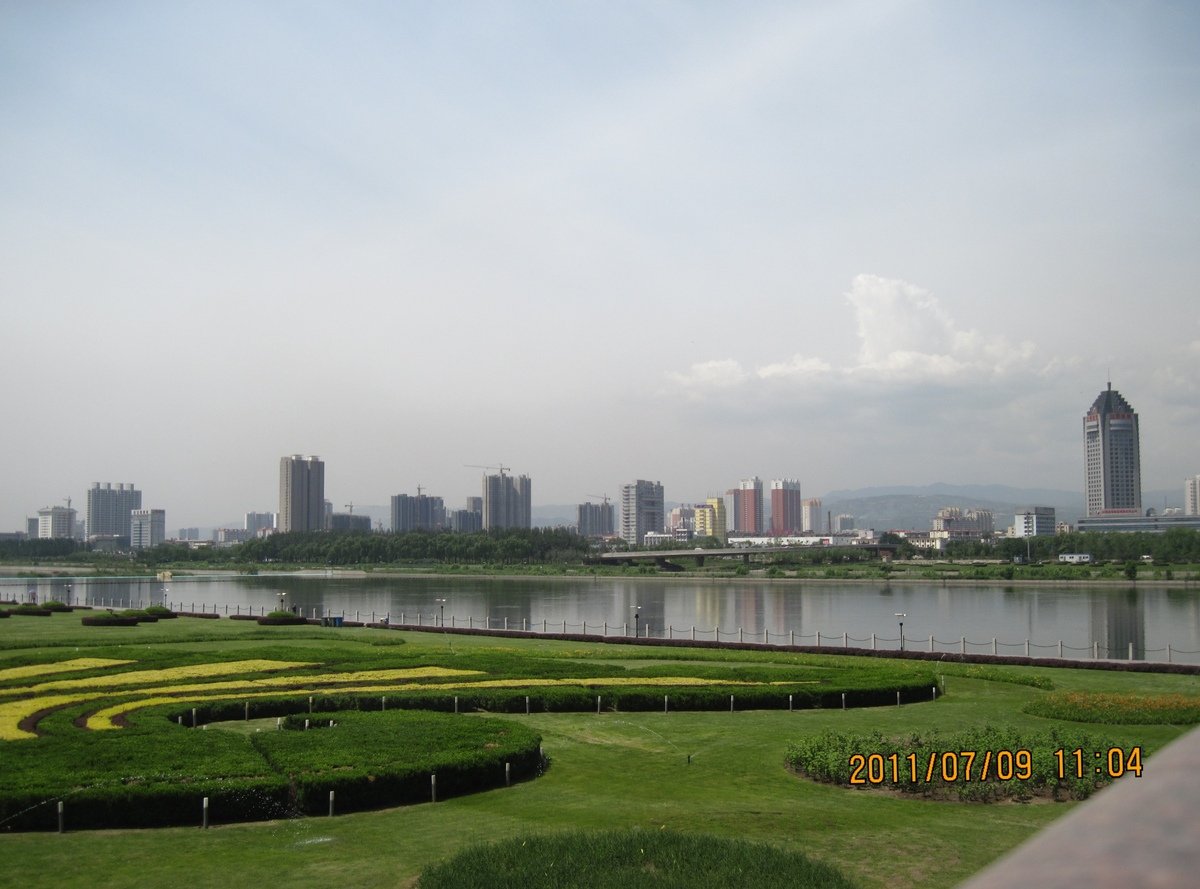
5. Fenhe Park Riverfront Walk
Snapshot
Itinerary
The route follows the paved riverside path through Fenhe Park and returns along the same corridor. AllTrails lists the trail as a 3.7 mile / 6.0 km out-and-back urban walk in Taiyuan, with broad paved paths along both banks of the Fen River. The walk can be shortened or extended along the park’s longer greenbelt.
Why it is essential
Fenhe Park is not a mountain route, but it is the most accessible way to read the Fen River basin below the Luliang escarpment. It also provides a verified, low-difficulty walking option for the region and connects the catalogue entry to the river that defines the escarpment’s eastern edge.
Equipment
Comfortable walking shoes, water, sun protection, and warm clothing in winter.
Hazards and notes
Urban path traffic, bicycles, summer heat, winter ice, and river-edge barriers are the main issues. Dogs may be allowed according to AllTrails, but current park regulations should be checked.
GPX / KML links
| Source | URL | Format / access | Reuse status |
|---|---|---|---|
| AllTrails: Fenhe Park | alltrails.com | Source map / trail page | AllTrails terms apply; downloadable GPX availability may require account; source-map reference only |
| OpenStreetMap search: Fenhe Park Taiyuan | openstreetmap.org | Source map | OSM data is ODbL; geometry cross-check only |
External links
External links
| Source | URL |
|---|---|
| China Daily — Jinci Tianlong Mountain Scenic Area | govt.chinadaily.com.cn |
| LoongWander — Tianlong Mountain Scenic Area | loongwander.com |
| China Daily Shanxi — Longshan Grottoes | shanxi.chinadaily.com.cn |
| China Educational Tours — Longshan Grottoes | chinaeducationaltours.com |
| China Daily Shanxi — Mengshan Giant Buddha | shanxi.chinadaily.com.cn |
| BH2255 — Juewei Mountain Travel Guide | bh2255.com |
| Chinatripedia — Juewei Mountain | chinatripedia.com |
| AllTrails — Fenhe Park | alltrails.com |
| CNTravelNav — Fenhe River Park | cntravelnav.com |