Regional overview
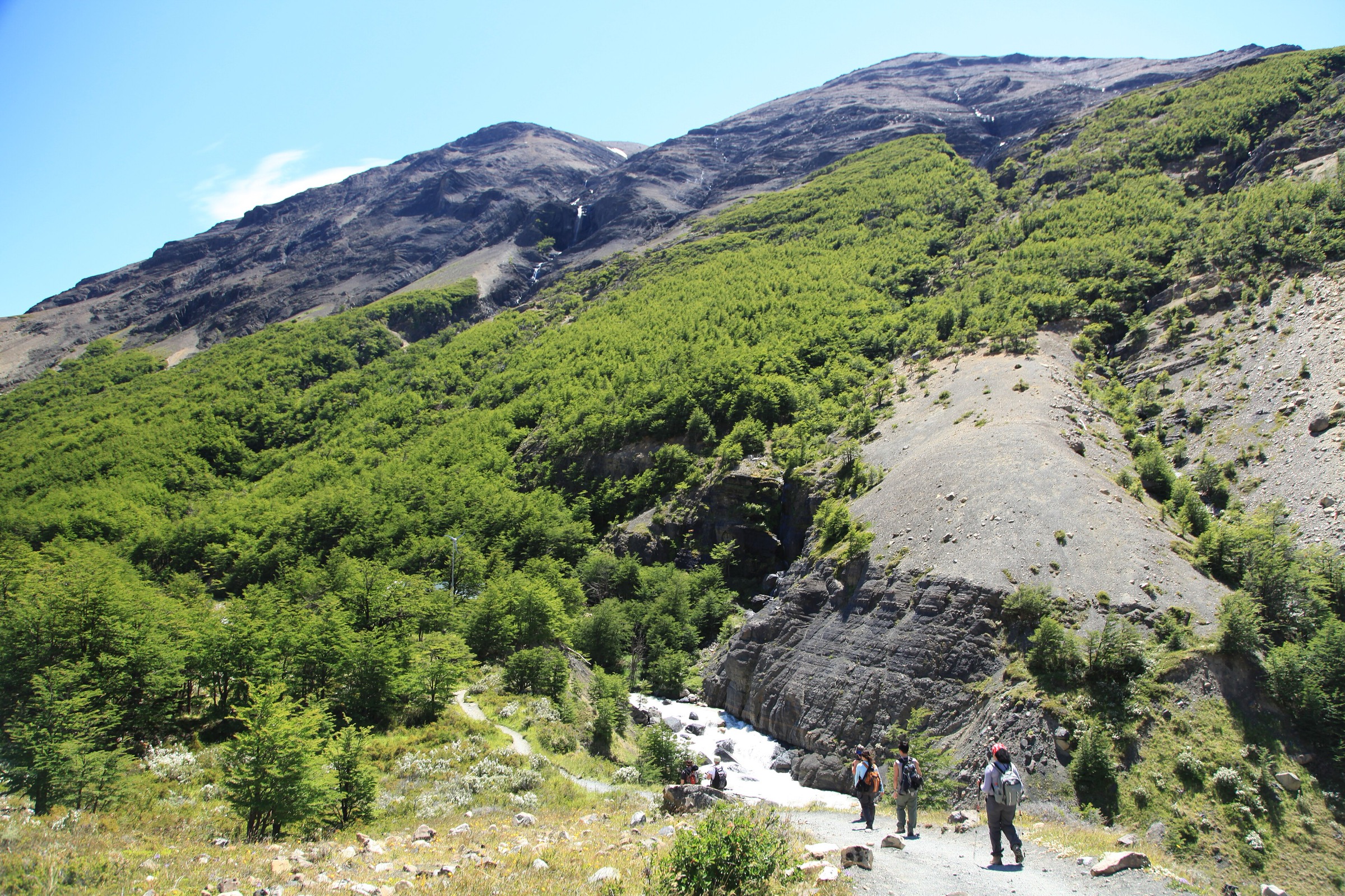
Torres del Paine is the best-known walking landscape in Chilean Patagonia: granite towers, the Cuernos del Paine, Paine Grande, lakes, lenga forest, wind-scoured steppe, hanging glaciers and the western outlet of the Southern Patagonian Icefield at Grey Glacier. Although the park is famous for the multi-day W and O circuits, several of its defining viewpoints can be walked as day hikes if transport, ferries, park tickets and timing are planned carefully.
The hiking character is marked by strong wind, rapidly changing weather, long daylight in summer, strict park management and highly concentrated visitor flows on the most famous routes. The east side provides the Base Las Torres ascent; the central sector gives Valle del Francés and Mirador Cuernos; the west side gives Grey Glacier and Mirador Ferrier. Routes can be straightforward in dry summer conditions but are exposed to cold rain, snow, high gusts, mud, steep moraine, forest sections and closure times.
The main season is October-April, with peak crowding and full services in December-February. Some shorter routes may be accessible outside that period, but ferry schedules, road conditions, park restrictions and accommodation/transport operations reduce options. All hikers should check CONAF, Pases Parques and concessionaire information before setting out.
Selection rationale
The selection covers the five essential day-hike experiences in the Cordillera del Paine: the iconic Base Las Torres lake viewpoint, the central French Valley / Mirador Británico route, the Grey Glacier approach from Paine Grande, the short Mirador Cuernos walk from Salto Grande, and the steep Mirador Ferrier viewpoint over the western lakes and massif. Full W/O circuit stages are included only where they function as one-day out-and-back objectives.
Summary table
| # | Hike | Country | Route type | Distance | Gain | Max elevation | Difficulty |
|---|---|---|---|---|---|---|---|
| 1 | Mirador Base Las Torres | Chile | Out-and-back | 20.6 km | 1,026 m | 872 m | Hard |
| 2 | Valle del Francés / Mirador Británico | Chile | Out-and-back from Camp Italiano; longer day from Paine Grande | 12.1 km from Italiano; about 20-24 km from Paine Grande | 638 m from Italiano | 760 m | Moderate-hard |
| 3 | Paine Grande to Grey Glacier viewpoints / Refugio Grey | Chile | Out-and-back | 23.2 km | 661 m | 263 m | Hard |
| 4 | Mirador Cuernos from Salto Grande | Chile | Out-and-back | 6.4 km | 194 m | 115 m | Easy |
| 5 | Mirador Ferrier | Chile | Out-and-back | 6.1 km | 652 m | 650 m | Hard |
1. Mirador Base Las Torres
Snapshot
Itinerary
The route starts in the Las Torres / Central sector and follows the Ascencio valley westward. It climbs through open slopes, passes the Chileno area, enters lenga forest and then ascends the steep moraine below the towers to reach the lake and viewpoint at Mirador Base Las Torres. The return follows the same route to the start.
AllTrails records 20.6 km out-and-back with 1,026 m of ascent and a maximum elevation of 872 m. It is a long and very popular day hike; the final moraine is slower than the lower valley distance suggests.
Why it is essential
Base Las Torres is the park’s signature day hike and one of the defining mountain viewpoints of Patagonia. The route reaches the classic glacial lake below the three granite towers that give the national park its name.
Equipment
Mountain hiking footwear, waterproof/windproof shell, warm layers, gloves and hat, sun protection, food, 2 litres or more of water, offline map/GPS and headtorch. Trekking poles help on the moraine and descent.
Hazards and notes
Crowding, wind, rain, snow, rockfall potential on the moraine, mud and strict closure/last-start times are the main issues. AllTrails notes that the final section may close in the afternoon; current CONAF or concessionaire timing should be checked before departure. Dogs are not allowed in the park.
GPX / KML links
| Source | URL | Format / access | Reuse status |
|---|---|---|---|
| AllTrails: Mirador Torres del Paine via Sendero Las Torres a Chileno | alltrails.com | Source map / downloadable route via AllTrails account | AllTrails terms apply; direct GPX not retrieved; source-map reference only |
| Pases Parques: Torres del Paine | pasesparques.cl | Official ticket/access source | Route-file terms not stated; official context only; no GPX found |
| OpenStreetMap search: Base Torres | openstreetmap.org | Map geometry cross-check | OSM data is ODbL; geometry cross-check target only |
External links
- CONAF — Parque Nacional Torres del Paine
- Pases Parques — Torres del Paine
- Ruta de los Parques — Torres del Paine National Park
- AllTrails — Mirador Torres del Paine via Sendero Las Torres a Chileno
2. Valle del Francés / Mirador Británico
Snapshot
Itinerary
From Camp Italiano, the trail climbs into Valle del Francés beside forest, moraine and views toward Glaciar Francés, Paine Grande and the Cuernos. It passes the French Valley viewpoints and continues through forest and rockier ground to Mirador Británico, one of the central amphitheatre viewpoints of the Paine massif. The return follows the same route.
AllTrails records the Mirador Británico via Valle Francés route as 12.1 km out-and-back with 638 m of ascent from the Italiano sector. A day-hike from Paine Grande requires adding the approach and return along Lago Skottsberg, making the practical total closer to a long 20-24 km day and dependent on the first and last catamaran times.
Why it is essential
Valle del Francés is the central scenic corridor of the W route. It gives glacier noise, hanging ice, forest and the granite amphitheatre of Mirador Británico in one route, making it the park’s essential central-valley day hike.
Equipment
Mountain hiking footwear, waterproof/windproof shell, warm layers, gloves and hat, sun protection, food, water, offline map/GPS and headtorch. Carry extra food and a margin for ferry delays if starting from Paine Grande.
Hazards and notes
The main risks are wind, rain, mud, late return after ferry delays, forested sections with limited visibility and closure/last-start times for the upper valley. If the final catamaran cannot be reached safely, the route should not be attempted as a day hike from Paine Grande.
GPX / KML links
| Source | URL | Format / access | Reuse status |
|---|---|---|---|
| AllTrails: Mirador Británico via Valle Francés | alltrails.com | Source map / downloadable route via AllTrails account | AllTrails terms apply; direct GPX not retrieved; source-map reference for Italiano-to-Británico leg only |
| OpenStreetMap search: Valle Frances Mirador Britanico | openstreetmap.org | Map geometry cross-check | OSM data is ODbL; geometry cross-check target only |
External links
- CONAF — Parque Nacional Torres del Paine
- Pases Parques — Torres del Paine
- AllTrails — Mirador Británico via Valle Francés
- Ruta de los Parques — Torres del Paine National Park
3. Paine Grande to Grey Glacier viewpoints / Refugio Grey
Snapshot
Itinerary
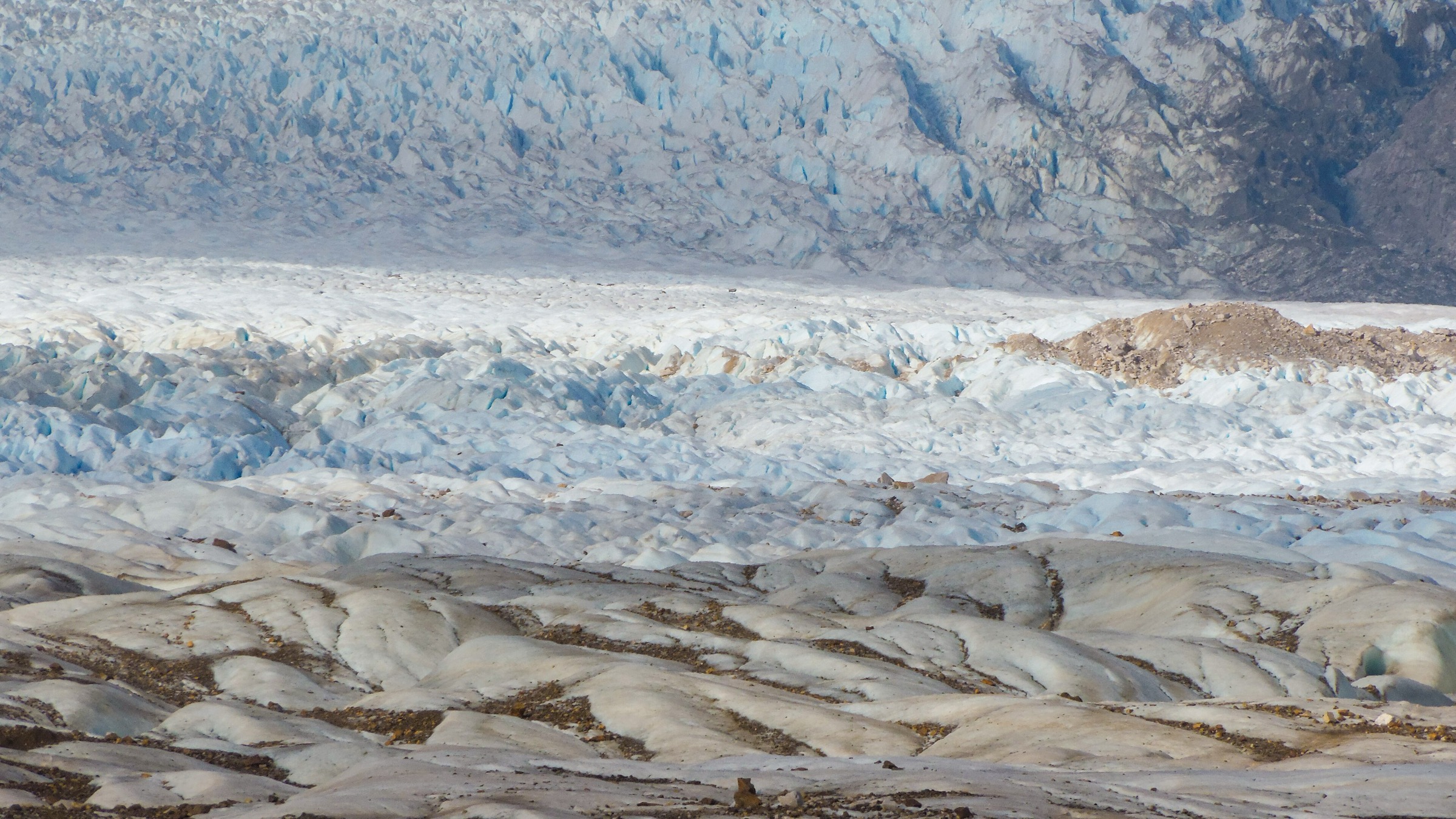
From Paine Grande, the route follows the western arm of the W route toward Lago Grey. It climbs gently through exposed terrain and forest patches, reaches viewpoints over Lago Grey with floating icebergs, then continues toward the Refugio Grey / glacier-view sector before returning by the same path. The best viewpoints look toward Grey Glacier, an outlet of the Southern Patagonian Icefield.
AllTrails records 23.2 km out-and-back with 661 m of ascent and a maximum elevation of 263 m. The route is feasible as a long day only if catamaran and bus schedules leave enough margin for wind delays and slower walking.
Why it is essential
This is the park’s essential glacier day hike. It gives a direct walking approach to Lago Grey, icebergs and the Southern Patagonian Icefield outlet without requiring the full W trek.
Equipment
Mountain hiking footwear, waterproof/windproof shell, warm layers, gloves and hat, sun protection, water, food, offline map/GPS and headtorch. Carry enough spare clothing for ferry or boat delays in cold wind.
Hazards and notes
Wind can be severe near Lago Grey and on exposed rises. Mud, rain, forest blowdown, late return, ferry cancellation and crowding are practical risks. Do not rely on a last-minute ferry connection without checking current schedules and weather.
GPX / KML links
| Source | URL | Format / access | Reuse status |
|---|---|---|---|
| AllTrails: Paine Grande - Glaciar Grey | alltrails.com | Source map / downloadable route via AllTrails account | AllTrails terms apply; direct GPX not retrieved; source-map reference only |
| OpenStreetMap search: Paine Grande Grey Glacier | openstreetmap.org | Map geometry cross-check | OSM data is ODbL; geometry cross-check target only |
External links
- CONAF — Parque Nacional Torres del Paine
- Pases Parques — Torres del Paine
- AllTrails — Paine Grande - Glaciar Grey
4. Mirador Cuernos from Salto Grande
Snapshot
Itinerary
The route starts near Salto Grande, where water flows between Lago Nordenskjöld and Lago Pehoé, then follows an open and gently rolling path toward the Cuernos viewpoint. The trail gives immediate views of the Paine massif, Lago Nordenskjöld, the Cuernos and the French Valley wall, with a short distance and modest elevation gain.
AllTrails records 6.4 km out-and-back with 194 m of ascent and a maximum elevation of 115 m. The trail is physically easy compared with Base Torres or Grey, but it is highly exposed to wind.
Why it is essential
Mirador Cuernos is the best short day hike in the park: low commitment, high scenic return and a direct view of the central Paine skyline. It is also a useful poor-weather or limited-time option.
Equipment
Comfortable walking or hiking shoes, windproof/waterproof jacket, warm layer, sun protection and water. Trekking poles are optional but helpful in high wind.
Hazards and notes
Wind is the main hazard and can be strong enough to make walking difficult near the lakes. Stay on the marked trail to avoid fragile vegetation. The trail can be busy because of its short approach and high scenic value.
GPX / KML links
| Source | URL | Format / access | Reuse status |
|---|---|---|---|
| AllTrails: Cuernos Lookout | alltrails.com | Source map / downloadable route via AllTrails account | AllTrails terms apply; direct GPX not retrieved; source-map reference only |
| OpenStreetMap search: Mirador Cuernos | openstreetmap.org | Map geometry cross-check | OSM data is ODbL; geometry cross-check target only |
External links
- CONAF — Parque Nacional Torres del Paine
- Pases Parques — Torres del Paine
- AllTrails — Cuernos Lookout
- Ruta de los Parques — Torres del Paine National Park
5. Mirador Ferrier
Snapshot
Itinerary
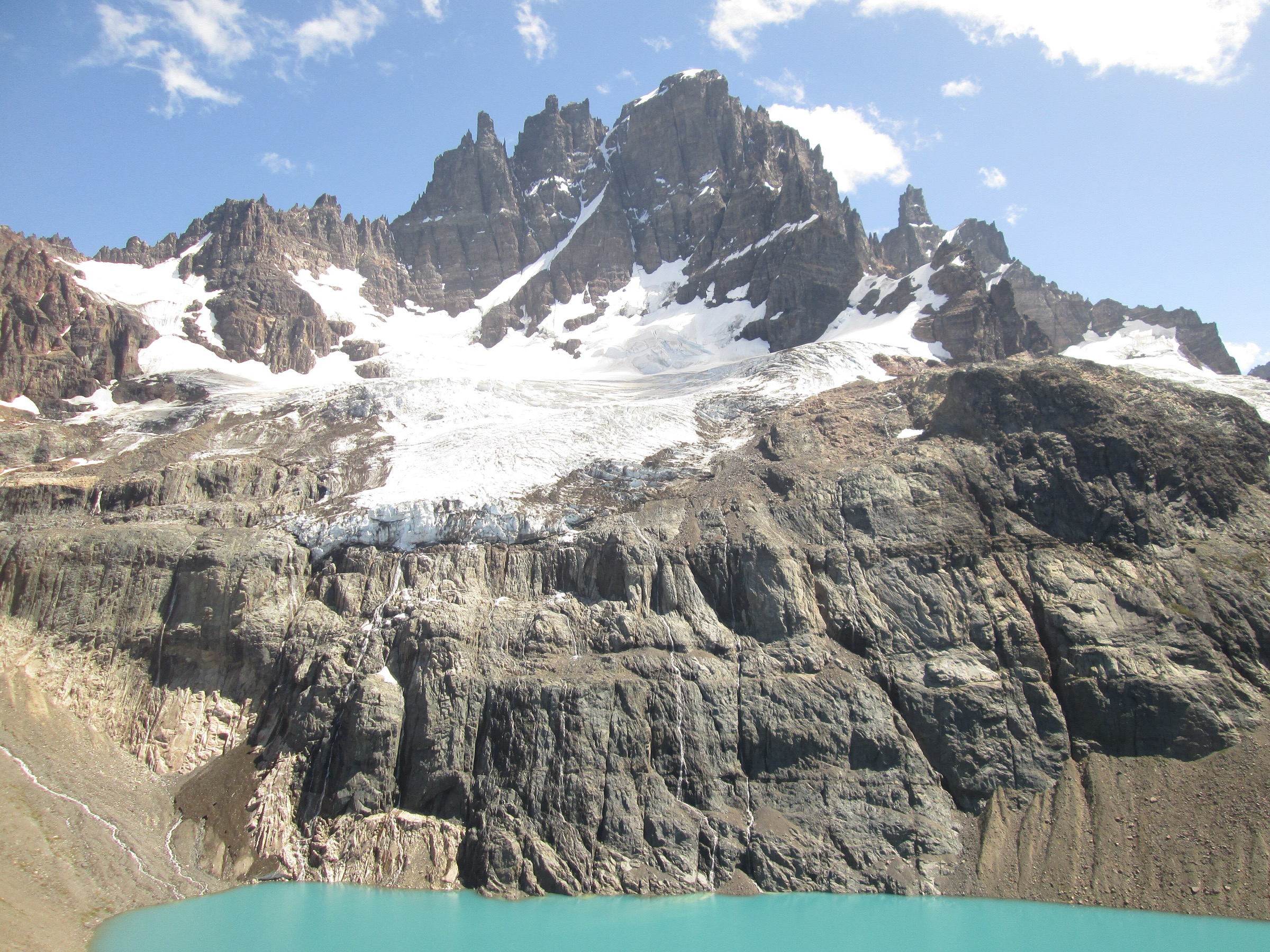
Mirador Ferrier is a short but steep climb on the western side of Torres del Paine. The trail ascends from the Grey sector through forest and open slopes to a high viewpoint over Lago Grey, Lago Pehoé, the Paine River, the Paine massif and the surrounding western park landscape.
AllTrails records 6.1 km out-and-back with 652 m of ascent and a maximum elevation of 650 m. The route is much harder than the distance suggests because the climb is continuous and steep.
Why it is essential
Ferrier gives one of the strongest high viewpoints reachable as a short day hike in Torres del Paine. It complements the long W-route objectives by showing the western lakes and massif from above.
Equipment
Sturdy hiking footwear, trekking poles, waterproof/windproof shell, warm layers, gloves and hat, water, food, sun protection, offline map/GPS and headtorch.
Hazards and notes
The trail is steep, muddy in places and exposed to strong wind near the top. AllTrails notes access to the trail until 14:00; current CONAF or ranger-station timing should be checked. Avoid the route in dangerous wind, poor visibility or icy conditions.
GPX / KML links
| Source | URL | Format / access | Reuse status |
|---|---|---|---|
| AllTrails: Ferrier Lookout | alltrails.com | Source map / downloadable route via AllTrails account | AllTrails terms apply; direct GPX not retrieved; source-map reference only |
| OpenStreetMap search: Mirador Ferrier | openstreetmap.org | Map geometry cross-check | OSM data is ODbL; geometry cross-check target only |
External links
- CONAF — Parque Nacional Torres del Paine
- Pases Parques — Torres del Paine
- AllTrails — Ferrier Lookout
External links
| Source | URL |
|---|---|
| CONAF — Parque Nacional Torres del Paine | conaf.cl |
| Pases Parques — Torres del Paine | pasesparques.cl |
| Ruta de los Parques — Torres del Paine National Park | rutadelosparques.org |
| AllTrails — Torres del Paine route pages | alltrails.com |
| AllTrails — Mirador Torres del Paine via Sendero Las Torres a Chileno | alltrails.com |
| AllTrails — Mirador Británico via Valle Francés | alltrails.com |
| AllTrails — Paine Grande - Glaciar Grey | alltrails.com |
| AllTrails — Cuernos Lookout | alltrails.com |
| AllTrails — Ferrier Lookout | alltrails.com |