Regional overview
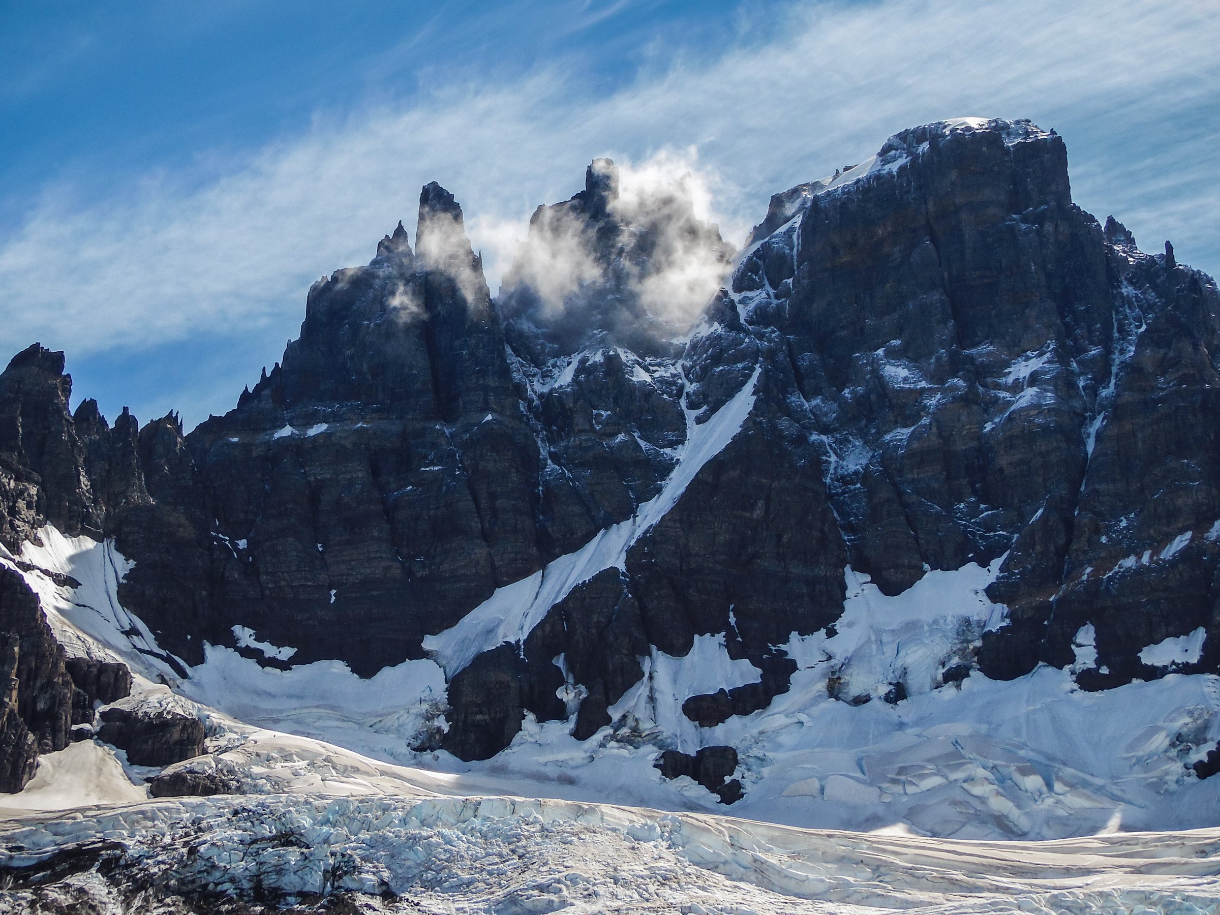
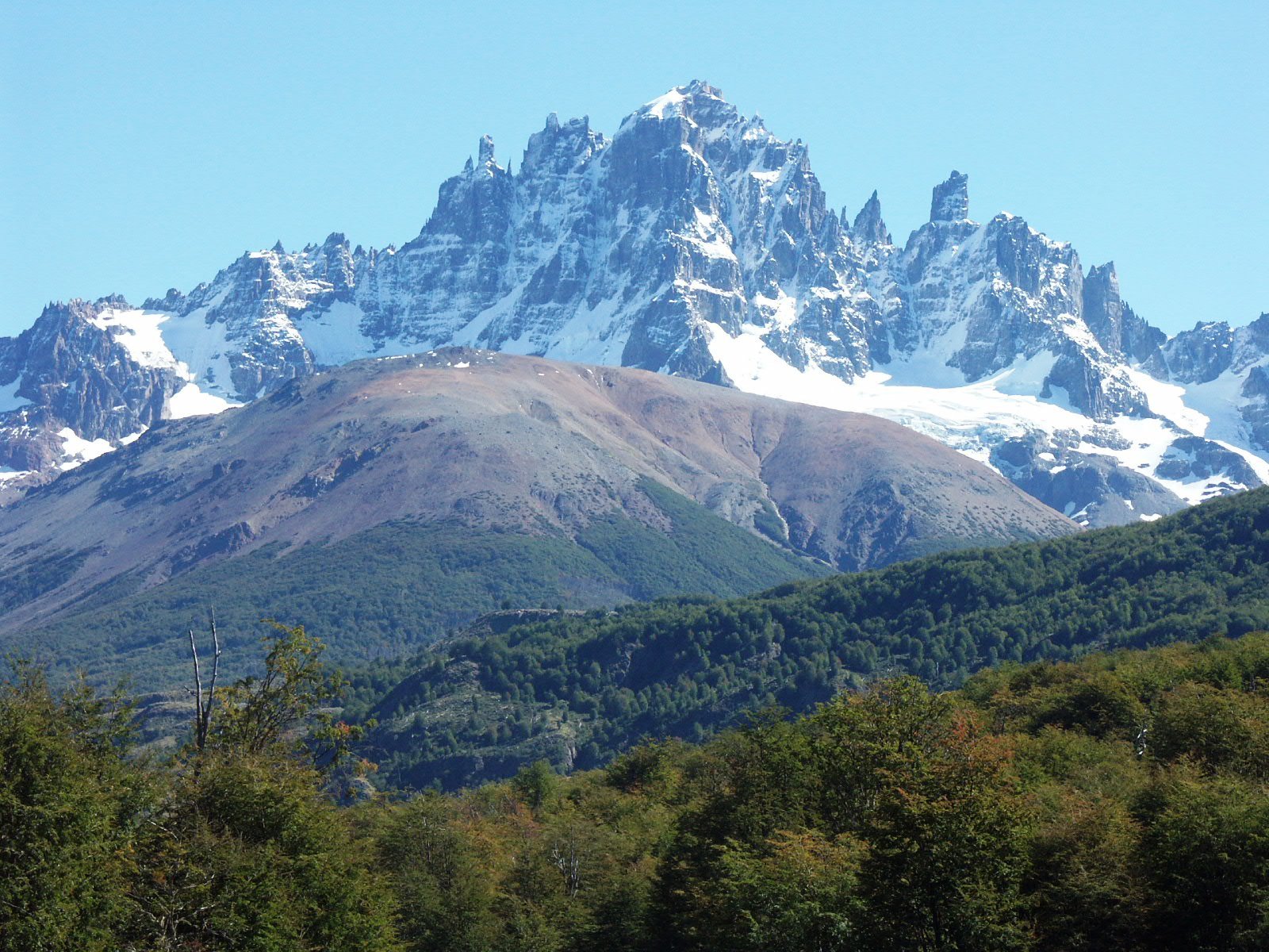
Cerro Castillo is one of the most dramatic walking areas on the Carretera Austral: serrated basalt-and-granite towers, glacial cirques, lenga forest, turquoise lagoons, steep moraines, and open Aysén valleys. The main access points are Villa Cerro Castillo, the Laguna Chiguay administration sector on Ruta 7, Las Horquetas, and Estero Parada.
The hiking character is more alpine than the map distances suggest. Trails climb steeply, cross exposed open slopes, and are affected by snow, rain, wind, cold, and rapid weather changes. CONAF states that temperatures in the area can range from -15 °C to 25 °C, and that adverse weather can temporarily close trails or protected areas.
Current access is a major issue. In the CONAF page checked for this pass, Sendero Laguna Castillo is closed by resolution and only enabled with certified guide/operator arrangements; Sendero Estero Parada has been closed to self-guided access since 29 May 2026 and requires guide plus prior authorisation through the regional office; Sendero Las Horquetas is closed by resolution and only enabled with certified guide. These notes must be refreshed before publication or field use.
Selection rationale
The selection covers the classic Laguna Cerro Castillo viewpoint, the short Chiguay forest/lake walk, the Estero Parada valley approach, and two one-day sections or side trips of the Las Horquetas/Cerro Castillo circuit. The last two are included because the region’s most essential terrain is bound to the circuit, but they are marked as restricted or section-route candidates rather than simple independent day hikes.
Summary table
| # | Hike | Country | Route type | Distance | Gain | Max elevation | Difficulty |
|---|---|---|---|---|---|---|---|
| 1 | Mirador Laguna Cerro Castillo from Villa Cerro Castillo | Chile | Out-and-back | 13.4–14.0 km | 1,125 m on AllTrails | Hard | |
| 2 | Sendero Laguna Chiguay | Chile | Out-and-back / short loop | 2.5 km | Easy | ||
| 3 | Sendero Estero Parada to Neozelandés sector | Chile | Out-and-back / access route | 12.0 km official | Moderate–hard | ||
| 4 | Las Horquetas to Campamento Río Turbio | Chile | Point-to-point circuit section | 15.45 km | 372 m on AllTrails section | Hard | |
| 5 | Neozelandés / Porteadores to Laguna Duff | Chile | Out-and-back / circuit side hike | 16.2–16.6 km depending on source | 589–854 m depending on source | Hard |
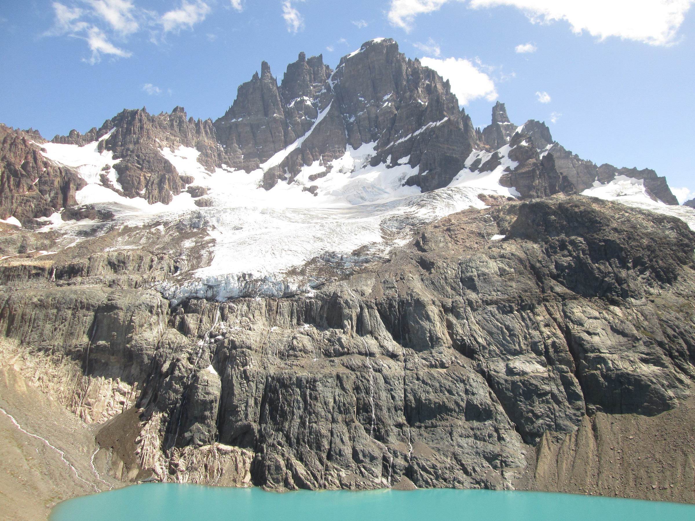
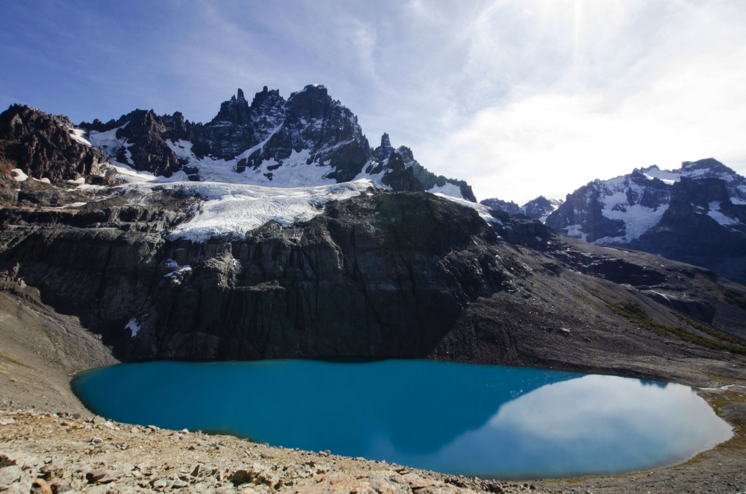
1. Mirador Laguna Cerro Castillo from Villa Cerro Castillo
Snapshot
Itinerary
The trail climbs from the Villa Cerro Castillo side through forest and open slopes to the glacial cirque below Cerro Castillo. The main objective is the turquoise Laguna Cerro Castillo and its viewpoint beneath the jagged summit ridge. The return follows the ascent line.
Why it is essential
This is the signature day hike of the region and the most direct day route to the classic Cerro Castillo lagoon view.
Equipment
- Sturdy boots
- Waterproof and windproof layers
- Warm layer
- Food, water and sun protection
- Map/GPS and headtorch
- Trekking poles for the steep descent
Hazards and notes
- CONAF lists the official trail as 14 km with an 8 h total time and notes hantavirus precautions
- The same CONAF page states that Sendero Laguna Castillo is closed by resolution and only enabled with certified guide/operator arrangements
- The trail closes from May to September, with winter entry only in company of a CONAF-endorsed guide
- Weather can close the route temporarily
GPX / KML links
| Source | URL | Format / access | Reuse status |
|---|---|---|---|
| Ruta de los Parques: Laguna Cerro Castillo KML | rutadelosparques.org | KML | Ruta de los Parques terms not fully evaluated; route file found, legal reuse unresolved |
| Ruta de los Parques: Cerro Castillo page | rutadelosparques.org | Source map / official-style route page | Site terms not fully evaluated; stats and KML source checked |
| AllTrails: Cerro Castillo Lagoon Viewpoint | alltrails.com | Source route / GPX via AllTrails account | AllTrails terms apply; secondary stats checked; direct reuse unresolved |
External links
- CONAF — Parque Nacional Cerro Castillo
- Ruta de los Parques — Cerro Castillo
- AllTrails — Cerro Castillo Lagoon Viewpoint
2. Sendero Laguna Chiguay
Snapshot
Itinerary
The route explores the Laguna Chiguay sector near the park administration, giving a short forest-and-lake walk in the more accessible part of the national park. It is the simplest representative route in the catalogue and a useful lower-elevation option when high trails are closed or unsuitable.
Why it is essential
Laguna Chiguay is the park’s administrative and visitor gateway on the Carretera Austral and provides a short, accessible contrast to the demanding high-cirque routes.
Equipment
- Hiking shoes
- Waterproof and warm layers
- Water and sun protection
- Basic navigation
- In winter, carry warmer layers and check road/ice conditions
Hazards and notes
- CONAF lists hantavirus precautions for this trail
- CONAF access note says Camping Laguna Chiguay is not operational, but the short trail remains listed under enabled trails
- Confirm the current park status before departure
GPX / KML links
| Source | URL | Format / access | Reuse status |
|---|---|---|---|
| CONAF Parque Nacional Cerro Castillo | conaf.cl | Official trail listing | CONAF website terms not evaluated for route-file reuse; official stats checked, no GPX/KML found |
External links
3. Sendero Estero Parada to Neozelandés sector
Snapshot
Itinerary
The Estero Parada approach enters a forested and glacial valley on the eastern side of the Cerro Castillo massif. It is commonly used as an access line to the Neozelandés sector and, with additional distance and permission, to Laguna Duff or parts of the circuit.
Why it is essential
Estero Parada gives access to some of the best inner Cerro Castillo cirque terrain without completing the entire Las Horquetas traverse.
Equipment
- Boots and waterproof clothing
- Warm layers
- Food and water
- Navigation backup and headtorch
- Guide-required winter/high-route equipment should be followed exactly when access is authorised
Hazards and notes
- CONAF states Sendero Estero Parada has been closed to self-guided access since 29 May 2026; access is only with a guide and prior authorisation through the regional office
- Route closes from May to September; winter entry only with a CONAF-endorsed guide and high-mountain clothing/equipment
- Hantavirus precautions apply
GPX / KML links
| Source | URL | Format / access | Reuse status |
|---|---|---|---|
| Ruta de los Parques: Cerro Castillo circuit KML | rutadelosparques.org | KML | Ruta de los Parques terms not fully evaluated; contains broader circuit geometry, direct reuse unresolved |
| AllTrails: New Zealand Trail – Duff Lake | alltrails.com | Source route / GPX via AllTrails account | AllTrails terms apply; related section stats checked, direct reuse unresolved |
| CONAF Parque Nacional Cerro Castillo | conaf.cl | Official trail listing | CONAF website terms not evaluated for route-file reuse; official access status checked, no dedicated GPX found |
External links
- CONAF — Parque Nacional Cerro Castillo
- Ruta de los Parques — Cerro Castillo
- AllTrails — New Zealand Trail / Duff Lake
4. Las Horquetas to Campamento Río Turbio
Snapshot
Itinerary
This route uses the first circuit section from the Las Horquetas side toward Campamento Río Turbio. It crosses valley and river terrain rather than reaching the famous lagoon viewpoint, but it represents the historical access into the Cerro Castillo traverse.
Why it is essential
Las Horquetas is the classic long-form approach to the Cerro Castillo massif. A single-day section is useful catalogue context, but current access rules mean it should not be promoted as a simple standalone hike.
Equipment
- Mountain hiking equipment plus river/wet-weather readiness
- Warm layers
- Food and water
- Navigation backup and headtorch
- For any authorised traverse section, carry the equipment specified by CONAF/guide/operator
Hazards and notes
- CONAF lists the full Las Horquetas trail as 53.5 km over 3–5 days and states that the route is closed by resolution except with certified guide
- Trail closes from May to September
- Hantavirus precautions and changing weather are significant
- A day-section return or pickup plan must be legal and confirmed locally
GPX / KML links
| Source | URL | Format / access | Reuse status |
|---|---|---|---|
| Ruta de los Parques: Cerro Castillo circuit KML | rutadelosparques.org | KML | Ruta de los Parques terms not fully evaluated; broader circuit geometry found, direct reuse unresolved |
| AllTrails: Las Horquetas Crossing — Booth to Camp Río Turbio | alltrails.com | Source route / GPX via AllTrails account | AllTrails terms apply; section stats checked, direct reuse unresolved |
| CONAF Parque Nacional Cerro Castillo | conaf.cl | Official trail listing | CONAF website terms not evaluated for route-file reuse; access status checked |
External links
- CONAF — Parque Nacional Cerro Castillo
- Ruta de los Parques — Cerro Castillo
- AllTrails — Las Horquetas Crossing section
5. Neozelandés / Porteadores to Laguna Duff
Snapshot
Itinerary
This route reaches or links the high Laguna Duff basin, one of the key scenic objectives of the Cerro Castillo circuit. Depending on the authorised access, it may be approached from the Neozelandés sector or as part of a Los Porteadores-to-Duff section. The route passes forest, river, moraine, and glacial-lake terrain.
Why it is essential
Laguna Duff is one of the major high-lagoon objectives in the Cerro Castillo massif and a natural counterpart to the more famous Laguna Cerro Castillo viewpoint.
Equipment
- Waterproof/windproof layers and warm layer
- Boots
- Food and water
- Navigation backup and headtorch
- Treat as high-route terrain: snow traction may be required in early or late season
Hazards and notes
- Not a simple independent day hike from a public roadhead in the current data
- Depends on legal access through Estero Parada or the circuit system, both subject to CONAF restrictions
- Keep this route as a candidate until an official permitted day itinerary is confirmed
GPX / KML links
| Source | URL | Format / access | Reuse status |
|---|---|---|---|
| Ruta de los Parques: Cerro Castillo circuit KML | rutadelosparques.org | KML | Ruta de los Parques terms not fully evaluated; broader circuit geometry found, direct reuse unresolved |
| AllTrails: New Zealand Trail – Duff Lake | alltrails.com | Source route / GPX via AllTrails account | AllTrails terms apply; section stats checked, direct reuse unresolved |
| AllTrails: Cerro Castillo Lagoons — Los Porteadores Camp to Duff Lagoon | alltrails.com | Source route / GPX via AllTrails account | AllTrails terms apply; alternative section stats checked, direct reuse unresolved |
External links
- CONAF — Parque Nacional Cerro Castillo
- Ruta de los Parques — Cerro Castillo
- AllTrails — Neozelandés to Duff Lake
- AllTrails — Los Porteadores to Laguna Duff
Missing data and follow-up
- Reconfirm the current CONAF restrictions before publication; the checked page states 29 May 2026 Estero Parada self-guided closure and guide/authorisation requirements.
- Find official elevation gain/loss and maximum elevation for Laguna Chiguay, Estero Parada, Las Horquetas sections, and Laguna Duff.
- Confirm whether any of the restricted circuit sections can be sold or described as standalone day hikes under current operator permits.
- Verify transport between Coyhaique, Villa Cerro Castillo, Laguna Chiguay, Las Horquetas, and Estero Parada.
- Determine the licence/reuse terms for Ruta de los Parques KML files before reusing geometry directly.
External links
| Source | URL |
|---|---|
| CONAF — Parque Nacional Cerro Castillo | conaf.cl |
| Ruta de los Parques — Cerro Castillo | rutadelosparques.org |
| Ruta de los Parques — Laguna Cerro Castillo KML | rutadelosparques.org |
| Ruta de los Parques — Cerro Castillo circuit KML | rutadelosparques.org |
| AllTrails — Cerro Castillo Lagoon Viewpoint | alltrails.com |
| AllTrails — New Zealand Trail / Duff Lake | alltrails.com |
| AllTrails — Las Horquetas Crossing section | alltrails.com |
| AllTrails — Los Porteadores to Laguna Duff | alltrails.com |