Regional overview
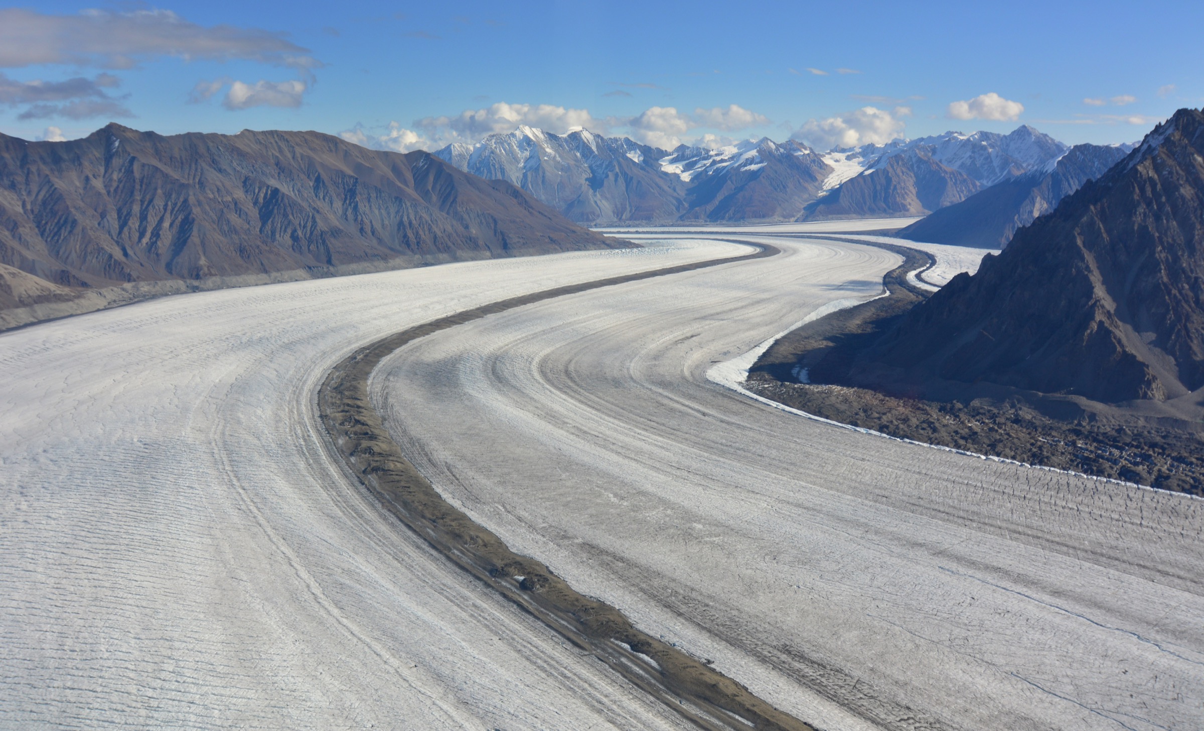
The Icefield Ranges form the inner, almost entirely glaciated core of the Saint Elias Mountains along the Yukon / Alaska / British Columbia border. They contain Mount Logan (5,959 m, the highest peak in Canada), Mount Saint Elias (5,489 m), Mount Lucania, King Peak, and Mount Steele, and feed the Hubbard, Logan, Kaskawulsh, Donjek, Steele, and Walsh icefields — the largest non-polar icefield system on Earth. Almost the entire core is roadless, crevassed, and accessible only by ski-plane out of Kluane Lake (Icefield Discovery and Trans North fly from the Burwash and Haines Junction airstrips) or by ski-plane from Yakutat and Haines, Alaska. These are alpinism and ski-mountaineering ranges. They are not hiking ranges in the conventional sense.
The honest consequence for a day-hike catalogue is that there are very few true single-day return walks that enter the Icefield Ranges proper. Day-hike access is overwhelmingly from the outer fringe — the Alaska Highway and Haines Highway corridor around Haines Junction and Kluane Lake — where the dry Kluane and Auriol front ranges rise from non-glaciated terrain immediately east of the ice. The summits in this fringe belt act as natural viewing balconies: Mount Decoeli, Mount Archibald, and Paint Mountain all face directly across the eastern Kluane Ranges into the icefield ranges proper. Aircraft access from Kluane Lake (Icefield Discovery) opens the only real means of standing on the icefields themselves, but the walking component on such a flight is a 45-minute amble around a base camp on the Kaskawulsh Glacier — flightseeing rather than trekking. Goatherd Mountain above the Lowell Glacier is the single classic Icefield Ranges day-hike viewpoint, but its only practical access is by raft from the Dezadeash River.
The hiking season is short. June to mid-September is the working window, with lingering snow on north aspects into early July, persistent grizzly bear activity, no cell coverage, fast-changing weather, and unbridged creek crossings on every fringe-summit route. Backcountry registration is required for all overnight use in Kluane National Park and Reserve between 1 April and 15 November, and aircraft-based trips are routinely cancelled or postponed for weather. Trailheads are reached by private vehicle along the Alaska Highway between Whitehorse, Haines Junction, and Burwash Landing; there is no scheduled public transport.
Selection rationale
The five entries deliberately combine the four best fringe day-summits that face directly into the Icefield Ranges with the one classic raft-accessed icefield viewpoint and the only realistic aircraft-accessed day-walk on the icefields themselves. Mount Decoeli and Mount Archibald are the two non-technical fringe summits on the Alaska Highway between Haines Junction and Burwash, both with confirmed summit views to Mount Logan, Mount Vancouver, Mount Hubbard, and Mount Kennedy. Paint Mountain / Tsí Dhǟl is the short, steep front-range balcony just above Haines Junction itself. Goatherd Mountain above the Lowell Glacier and Lowell Lake is included on the strength of its unique status as the canonical Icefield Ranges day-viewpoint, with the clear caveat that it is only reached by raft. The Icefield Discovery skiplane day-walk at the Kaskawulsh base camp is included as the only practical way for a non-mountaineer to spend a day among the icefield peaks themselves, with the equally clear caveat that flying time exceeds walking time. Outpost Mountain is occasionally cited as a Kluane day-summit but does not appear in current trip-report databases as a credibly locatable named day route, and has been deliberately omitted.
The canonical front-country park trails — King’s Throne, Auriol Loop, Thechàl Dhâl (Sheep Mountain) Ridge, Bullion Plateau, St Elias Lake, Dezadeash River, Rock Glacier — are covered in the sister article on Kluane National Park. The Haines Highway and BC-side hikes south of Kluane proper (Three Guardsmen, Million Dollar Falls, Kelsall Lake, Mush Lake / Bates Lake, the Datlasaka Range and the lower Tatshenshini–Alsek corridor) are covered in the Alsek / Tatshenshini sister article.
Summary table
| # | Hike | Country | Route type | Distance | Gain | Max elevation | Difficulty |
|---|---|---|---|---|---|---|---|
| 1 | Mount Decoeli from the Alaska Highway | Canada (Yukon) | Out-and-back | 18 km | 1,332 m | 2,332 m | Hard |
| 2 | Mount Archibald from Jarvis River | Canada (Yukon) | Out-and-back | 28-29 km | 1,950 m | 2,588 m | Very hard |
| 3 | Paint Mountain / Tsí Dhǟl from Pine Lake | Canada (Yukon) | Out-and-back | 4.2 km | 714 m | 1,477 m | Hard (short and steep) |
| 4 | Goatherd Mountain above Lowell Lake (raft access) | Canada (Yukon) | Out-and-back | 10 km | 820 m | 1,806 m | Hard |
| 5 | Kaskawulsh Glacier skiplane day-walk from Kluane Lake | Canada (Yukon) | Aircraft-accessed walk | 1-2 km on the ice | Negligible | 1,800 m at camp | Easy on foot, weather-dependent |
1. Mount Decoeli from the Alaska Highway
Snapshot
Itinerary
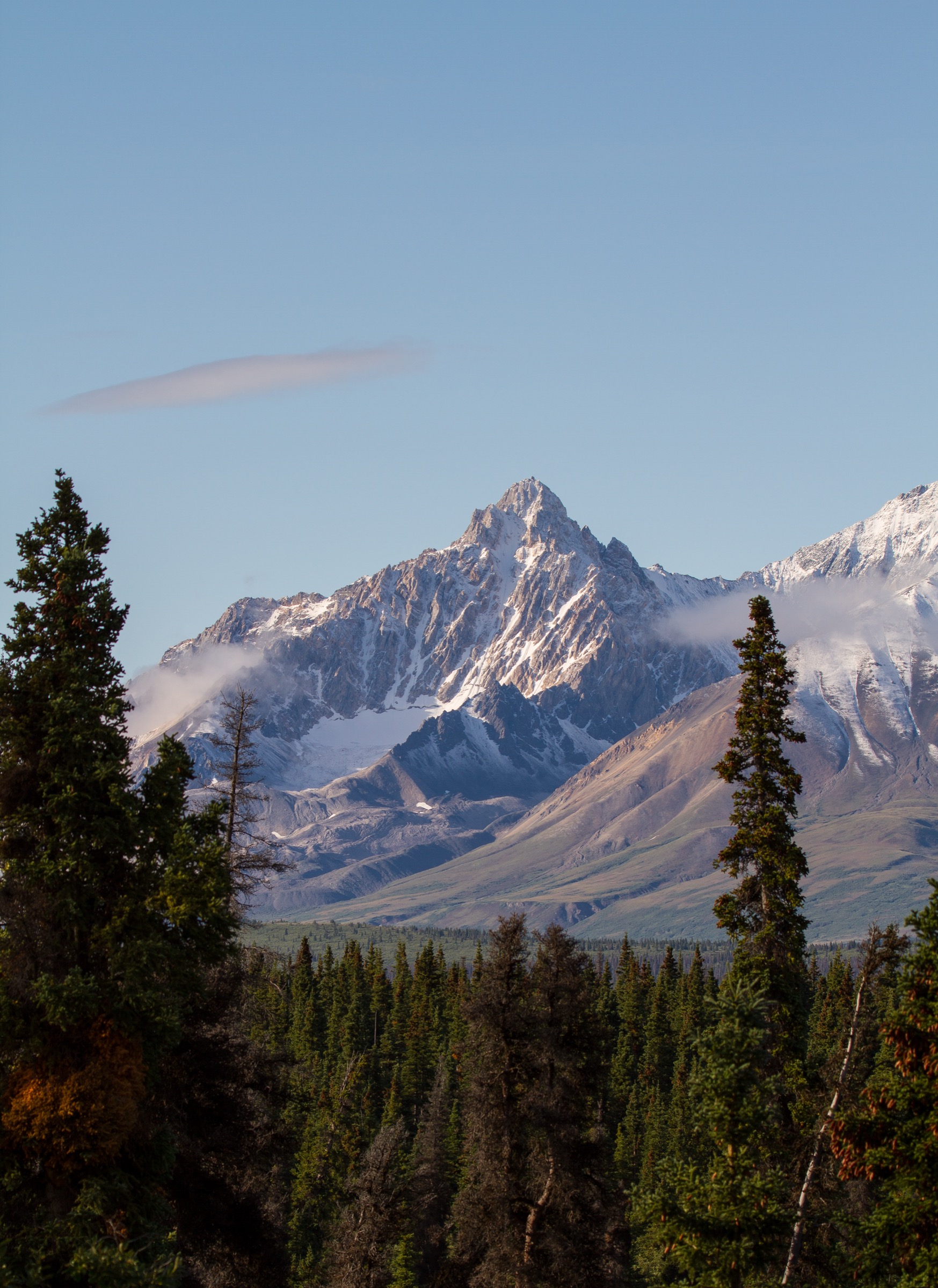
The route leaves a small parking area on the west side of the Alaska Highway, marked by flagging tape and a rock cairn rather than any sign, and follows a flagged informal path westwards for about 1 km to Summit Creek. The line then climbs the broad valley floor on a long, gentle gradient of broken river rock, gains the open green hillsides of the upper basin, and breaks out above the last vegetation onto a steady ridge of fractured rock leading north-west to the summit ridge. The final 240 m onto the pyramidal summit cone is steep, loose, and demands attention on the descent. The summit itself sits at 2,332 m, a Kluane-Range outlier facing directly west into the heart of the Icefield Ranges, and gives one of the most complete fringe-summit panoramas in the territory — on a clear day Mount Logan, Mount Vancouver, Mount Kennedy, Mount Hubbard, Mount Alverstone, and the Weisshorn group are all visible above the ice. Return is by the same line.
Why it is essential
Mount Decoeli is the strongest non-technical day-summit on the eastern fringe of the Icefield Ranges. Few hiking objectives anywhere in the Yukon combine a roadside trailhead, a clean walking and easy-scrambling line without glacier travel, and a summit that looks straight into the headwaters of the Hubbard and Kaskawulsh icefields. It is the de-facto reference day-summit for visitors who want to see the icefield peaks without flying.
Equipment
Mountain hiking equipment: sturdy boots, trekking poles, weatherproof shell, warm layers, hat and gloves outside high summer, plenty of water and food, sun protection at altitude, navigation backup, and a headtorch in case the descent runs late. Bear-aware food storage and bear spray are strongly recommended; this is active grizzly country. Microspikes are useful into early July for residual snow on the upper cone.
Hazards and notes
The trailhead is unsigned and easily missed on first approach. Summit Creek must be crossed and can be high after rain or warm spells. The summit cone is loose, exposed, and not suitable in wet or icy conditions; the upper route is genuinely committing in poor visibility. Weather closes in very quickly off the icefields and is the dominant turn-back factor. Grizzly bears use the valley year-round. There is no mobile coverage from the trailhead onwards. The route runs through Champagne and Aishihik First Nations traditional territory; respect signage and any seasonal restrictions.
GPX / KML links
| Source | URL |
|---|---|
| Yukon Hiking — Mount Decoeli (route description and downloadable track) | yukonhiking.ca |
| AllTrails — Mount Decoeli | alltrails.com |
External links
- Parks Canada — Mount Decoeli Route
- Wikipedia — Mount Decoeli
- PeakVisor — Mount Decoeli
- hktreks — Mount Decoeli trip report
2. Mount Archibald from Jarvis River
Snapshot
Itinerary
From a small pull-off on the west side of the Alaska Highway just before Bear Creek Lodge, the route follows a faint cleared corridor through willow and alder along the north bank of Thunderegg Creek, gaining the lower Jarvis River drainage. Recent washouts have moved the line in 2022-2025; trip reports from 2024 and 2025 confirm a re-cleared willow tunnel and a workable footpath into the upper basin, though water levels can shift dramatically between morning and evening. After approximately 9 km of valley travel the route climbs out of the trees onto a broad alpine bench beneath the south-east ridge of Mount Archibald, then turns up the ridge proper. The upper ridge is a sustained exposed scramble on loose rock; the summit dome at 2,588 m gives one of the deepest fringe-summit views available, with Mount Logan, Mount Vancouver, Mount Kennedy, and the broken ice of the Kluane and Hubbard icefield headwaters all visible to the west. Descent is by the same line.
Why it is essential
Mount Archibald is the second of the two roadside fringe summits that look directly into the Icefield Ranges proper, and the only one of the two that gains more than 1,900 m without a glacier or technical route. Trip reports consistently single it out for the view down onto the Kluane Icefields. It is included as the long, strenuous alternative to Mount Decoeli for parties who want the deepest possible icefield-ranges panorama from a roadside start, and who can move efficiently on loose alpine terrain.
Equipment
Mountain hiking equipment in full: stiff boots, gaiters, trekking poles, a serious weatherproof shell, warm layers, hat and gloves, sun protection, plenty of water and electrolytes, navigation backup, a headtorch, and bear spray. A helmet is recommended on the upper south-east ridge for loose rock. Many parties carry bivouac gear in case the descent runs into the night.
Hazards and notes
This is not a casual day-hike. The exposure, scrambling, and distance combine to put it close to the top of the difficulty scale among Yukon day objectives. The Thunderegg Creek access washed out in 2022 and remains unstable; check current conditions through yukonhiking.ca or with the Kluane Park visitor centre in Haines Junction before committing. Water levels in Thunderegg Creek and the upper Jarvis can rise rapidly with warm afternoons and rain. Grizzly bears use the willow flats. There is no mobile coverage. Backcountry permit registration is required for any overnight stay in the national park, and parties planning the long single-day variant should leave a detailed itinerary with a reliable contact.
GPX / KML links
| Source | URL |
|---|---|
| Yukon Hiking — Mount Archibald | yukonhiking.ca |
| AllTrails — Mount Archibald | alltrails.com |
External links
3. Paint Mountain / Tsí Dhǟl from Pine Lake
Snapshot
Itinerary
The trail begins at the very end of Pine Lake Road, leaves the residential cul-de-sac on a marked walkway easement, and climbs through spruce on a worn but unsignposted path. After roughly 800 m the line steepens onto an old cable cutline that runs almost vertically up the south-west face — there are no switchbacks, and the cutline gains 700 m of elevation in 2.4 km. The summit at 1,477 m carries a helipad, a fire-lookout tower, and communication infrastructure. From the helipad the panorama opens north over Pine Lake (Tsí Män in Southern Tutchone, “red ochre lake”), west across the Dezadeash valley to the Auriol Range and Mount Martha Black, and south-west into the front of the Kluane Range, with the Icefield Ranges visible behind on a clear day. Return is by the same cutline; trekking poles are extremely useful on the descent.
Why it is essential
Paint Mountain is the shortest fringe-summit balcony in the area and the only one that can be done in half a day from Haines Junction itself. Its summit lookout is the natural orientation hike for any visitor approaching the Icefield Ranges for the first time. Tsí Dhǟl, the Southern Tutchone name, refers to the red ochre once mined here for dye by the Champagne and Aishihik First Nations.
Equipment
Standard mountain hiking kit: sturdy hiking shoes or light boots, trekking poles (essential on the descent), weatherproof shell, sun protection, water, snacks, and insect repellent. Bear spray is recommended in spring and early summer.
Hazards and notes
The route lies on Category B Settlement Land of the Champagne and Aishihik First Nations and is not an officially maintained Parks Canada trail. Respect any closure or seasonal signage and stay off the cable infrastructure. The cutline is loose, dusty, and very steep, with significant slip risk on the descent — this is genuinely the steepest sustained gradient in the regional day-hike catalogue. Parking in the residential cul-de-sac must be respectful of private driveways. Black bears are regularly seen on the lower slopes.
External links
- Yukon Hiking — Paint Mountain
- The Globe Backpacker — Paint Mountain Hike near Kluane National Park
- AllTrails — Paint Mountain
- Mountain Project — Paint Mountain / Tsí Dhǟl
4. Goatherd Mountain above Lowell Lake (raft access)
Snapshot
Itinerary
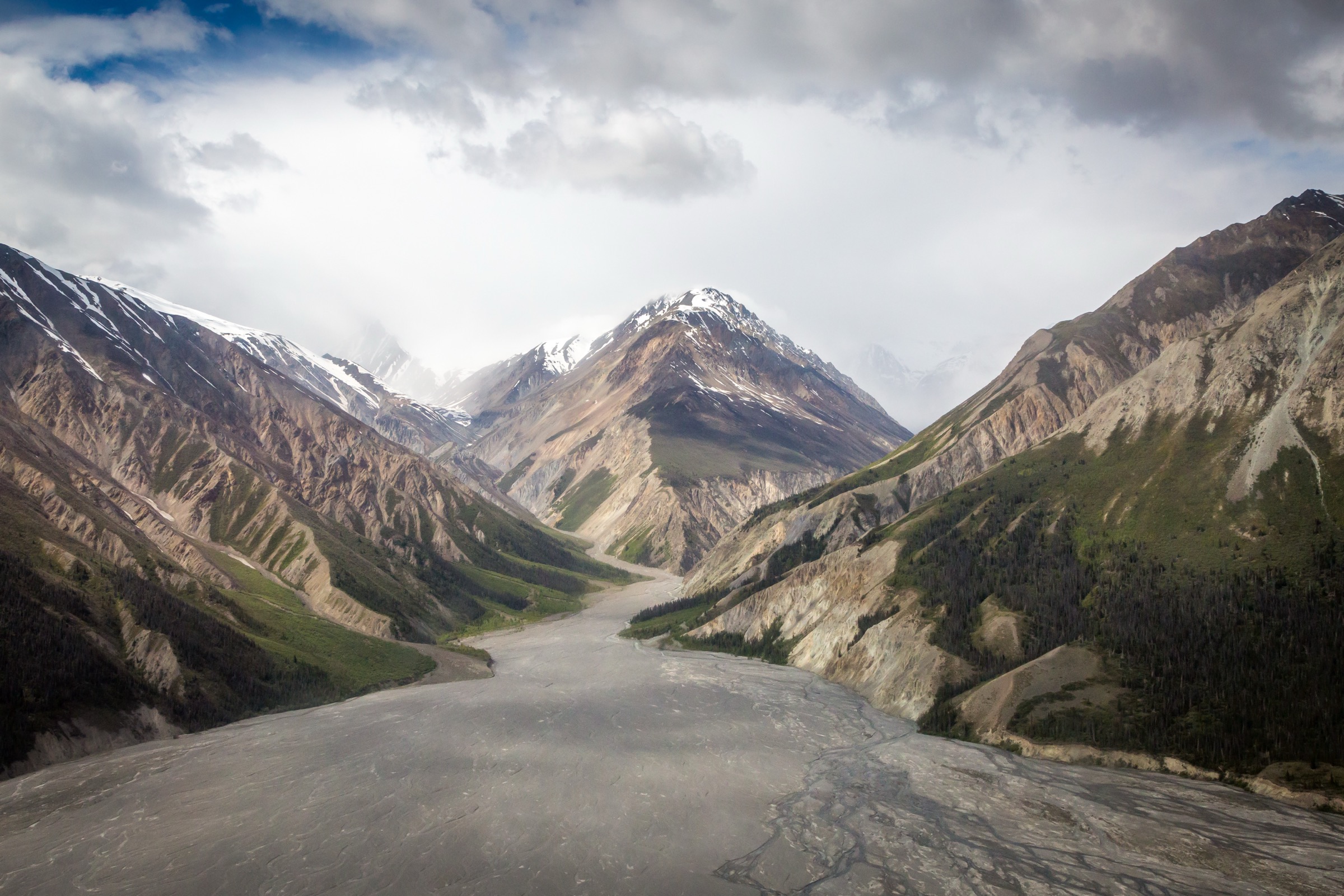
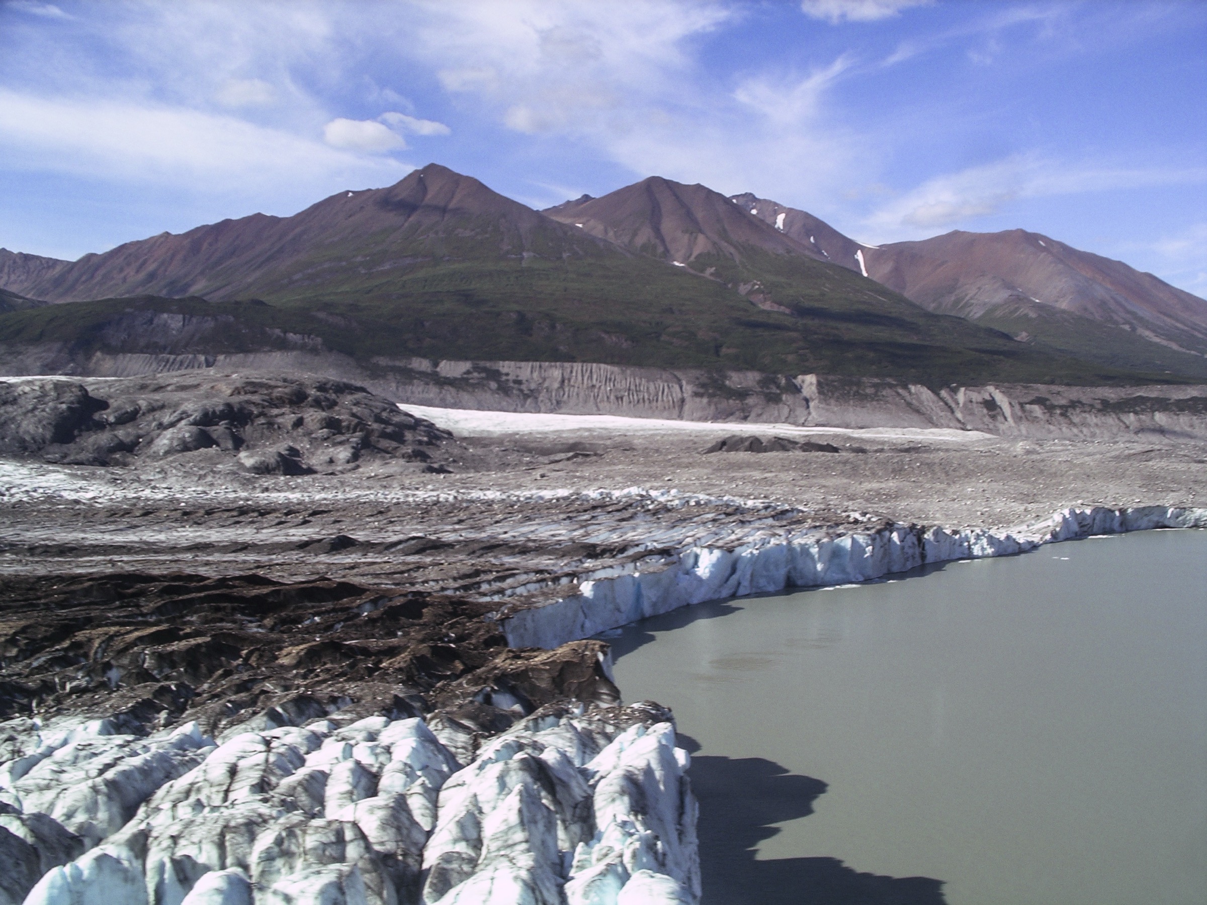
The route starts from the standard rafting camp on the alluvial flats below Goatherd Mountain on the north-east shore of Lowell Lake, after a 2-3 day raft descent of the Dezadeash River into the Alsek system. From camp the line climbs north-east up grassy benches and scree onto the south-west shoulder, gaining the broad alpine ridge at around 1,400 m. The shoulder gives the classic view: Lowell Lake spread out below, studded with calving icebergs, and the Lowell Glacier — fed from Mount Kennedy and the Hubbard icefield headwaters — driving down into the lake. A continuation along the ridge leads to the 1,806 m summit on broken alpine and short stretches of exposed bouldering. Mountain goats — the namesake population, more than a hundred animals — are commonly seen on the upper slopes. Descent is by the same line.
Why it is essential
Goatherd Mountain is the single canonical Icefield Ranges day-hike viewpoint. From the upper shoulder the walker stands above an actively calving tidewater-style glacier draining the inner Hubbard icefield, with more than 50 km of the Lowell Glacier visible upstream to Mount Kennedy (4,238 m). No fringe summit on the road system gives this view of the ice; no road-accessible day hike in Kluane offers anything comparable. The trade-off — raft access from Haines Junction — is acknowledged frankly: it is included because it remains a day-hike in walking terms, and because skipping it would mean omitting the most iconic single image of the Icefield Ranges accessible on foot.
Equipment
Mountain hiking kit suitable for off-trail alpine terrain: stiff boots, gaiters, trekking poles, weatherproof shell, warm layers, sun protection, plenty of water, and a packed lunch. A bear bell or other noise-maker is sensible; grizzly bears are present in the area, though the resident mountain goats are the more common sight. Most parties travel as part of a commercial rafting expedition that provides bear-aware food storage and group safety logistics; independent access requires significant whitewater, glacier-lake, and wilderness experience.
Hazards and notes
The Lowell Glacier face is actively calving and small-tsunami risk applies to anyone standing on the shoreline; keep well back from the lake edge. The summit boulder field is loose and exposed. The route is unmaintained, unmarked, and entirely off-trail. Weather closes in fast off the icefield. There is no mobile coverage; satellite communication is recommended. Parks Canada backcountry registration is required for any overnight use in the park, and the standard access via the Alsek / Tatshenshini system is heavily regulated by permit-based rafting season. Commercial rafting operators (Canadian River Expeditions, Haines Rafting Company, OARS, and others) handle permits and group logistics for the most common access.
External links
- Parks Canada — Kluane National Park and Reserve
- Canadian River Expeditions — Upper Alsek River Rafting Expedition
- Haines Rafting Company — Upper Alsek itinerary
- PeakVisor — Goatherd Mountain
5. Kaskawulsh Glacier skiplane day-walk from Kluane Lake
Snapshot
Itinerary
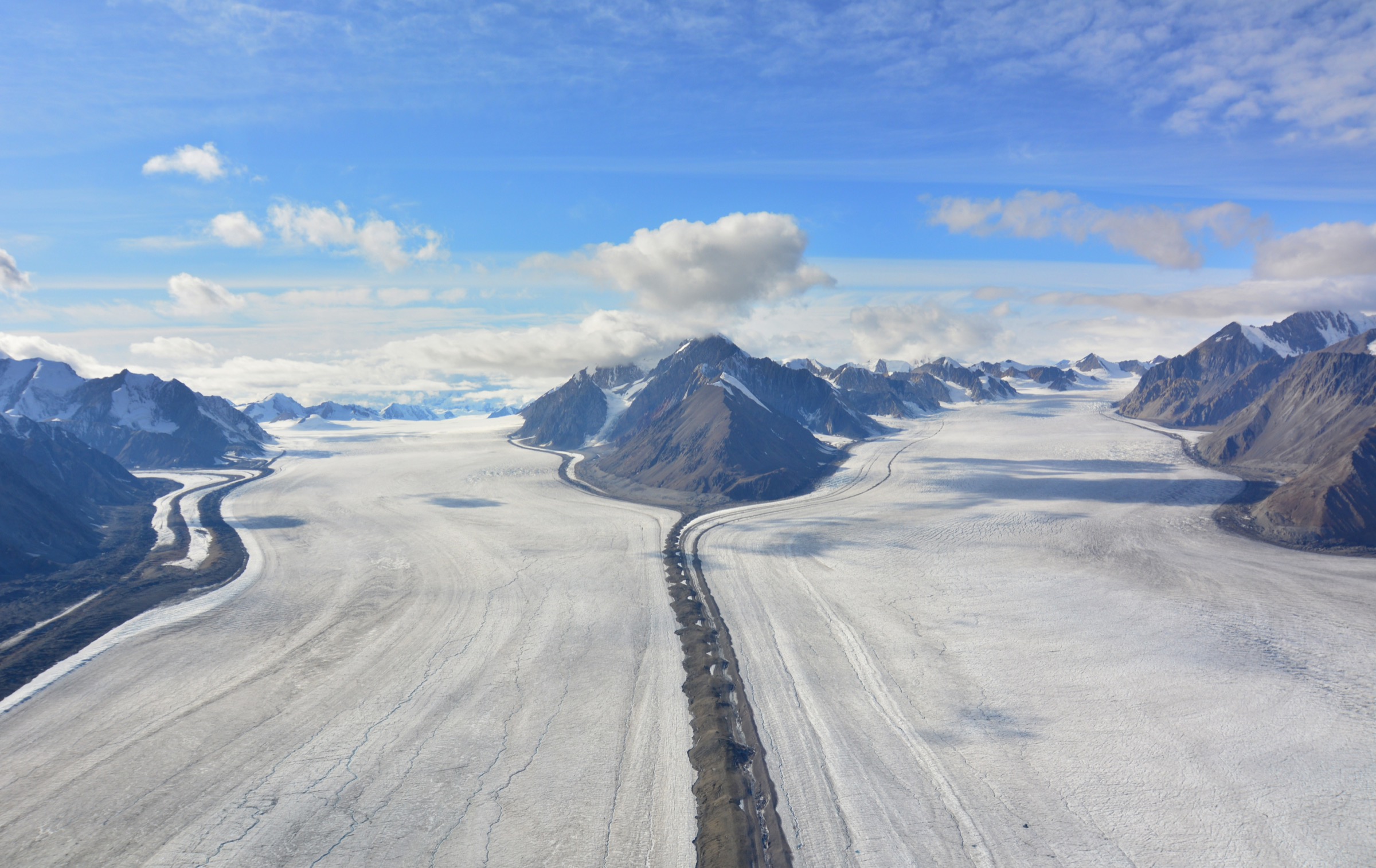
The standard flightseeing-with-landing tour leaves the Icefield Discovery base on the southern shore of Kluane Lake in a Helio Courier or Pilatus Porter ski-equipped aircraft. The outbound flight tracks south-west up the Slims River valley, over the lower Kaskawulsh, and across roughly 45 minutes of glaciated terrain to the operator’s seasonal base camp on the upper Kaskawulsh Glacier, around 35 km from Mount Logan. After landing on the prepared snow strip the group has approximately 45 minutes off the aircraft, walking the marked, flagged area around the camp, looking up at the Mount Logan massif, King Peak, and the rim of the Kaskawulsh basin, and (in the longer multi-day variant) staying in a heated 16 × 32 ft hut. The return flight typically takes a different line to give a second perspective on the Kaskawulsh and Slims systems. The walking component is short and level by design — this is flightseeing access, not a glacier trek — but it is the only legitimate way for a non-roped, non-mountaineering visitor to stand on the icefield itself.
Why it is essential
Every other entry in this catalogue is a fringe walk that looks into the Icefield Ranges from outside. This is the one entry that actually puts the walker on the icefield itself. Including it is a deliberate decision to give an honest picture of how the inner ranges can be experienced on foot at all, and to draw a clear line between the fringe day-summits and the genuine icefield interior.
Equipment
Warm layers, glacier-strength sunglasses, ski goggles or a peaked hat for snow glare, thick gloves, and stiff-soled walking boots are essential even in summer — the camp sits on a snow surface around 1,800 m and the wind off Mount Logan is cold in any season. Sunscreen and lip balm with high SPF are required. The operator supplies safety briefings, flagging, and on-ice guidance.
Hazards and notes
Aircraft access is entirely weather-dependent and trips are routinely delayed, shortened, or cancelled for cloud, wind, and ice conditions; flexible itineraries are essential. Once on the ice, walkers stay within the operator’s flagged perimeter — crevasses lie outside it. The Kaskawulsh basin has rapidly changing weather and sun-reflective glare that can cause snow blindness within an hour. There is no mobile coverage; the camp communicates by satellite. Independent landings on the icefield are not permitted under Parks Canada regulations.
External links
- Icefield Discovery — Access Kluane Icefield
- Travel Yukon — Icefield Discovery Tours
- ExploreNorth Blog — By skiplane to Mount Logan
- Alpine Club of Canada — Yukon Icefield Discovery Camp
External links
| Source | URL |
|---|---|
| Parks Canada — Kluane National Park and Reserve | parks.canada.ca |
| Parks Canada — Mount Decoeli Route | parks.canada.ca |
| Yukon Hiking — Kluane region index | yukonhiking.ca |
| Yukon Hiking — Mount Decoeli | yukonhiking.ca |
| Yukon Hiking — Mount Archibald | yukonhiking.ca |
| Yukon Hiking — Paint Mountain | yukonhiking.ca |
| Travel Yukon — Hiking in Kluane National Park | travelyukon.com |
| Wikipedia — Saint Elias Mountains | en.wikipedia.org |
| Wikipedia — Mount Logan | en.wikipedia.org |
| Wikipedia — Mount Decoeli | en.wikipedia.org |
| Wikipedia — Mount Archibald | en.wikipedia.org |
| PeakVisor — Mount Decoeli | peakvisor.com |
| PeakVisor — Mount Archibald | peakvisor.com |
| PeakVisor — Goatherd Mountain | peakvisor.com |
| PeakVisor — Saint Elias Mountains range | peakvisor.com |
| AllTrails — Mount Decoeli | alltrails.com |
| AllTrails — Mount Archibald | alltrails.com |
| AllTrails — Paint Mountain | alltrails.com |
| Mountain Project — Paint Mountain / Tsí Dhǟl | mountainproject.com |
| Icefield Discovery | icefielddiscovery.com |
| Travel Yukon — Icefield Discovery Tours | travelyukon.com |
| ExploreNorth Blog — By skiplane to Mount Logan | explorenorthblog.com |
| Canadian River Expeditions — Upper Alsek River | nahanni.com |
| Haines Rafting Company — Upper Alsek itinerary | hainesrafting.com |
| hktreks — Mount Decoeli trip report | hktreks.com |
| The Globe Backpacker — Paint Mountain Hike | theglobebackpacker.com |
| Wikimedia Commons — Kluane National Park category | commons.wikimedia.org |
| Wikimedia Commons — Kaskawulsh Glacier category | commons.wikimedia.org |
| Wikimedia Commons — Lowell Glacier category | commons.wikimedia.org |