Regional overview
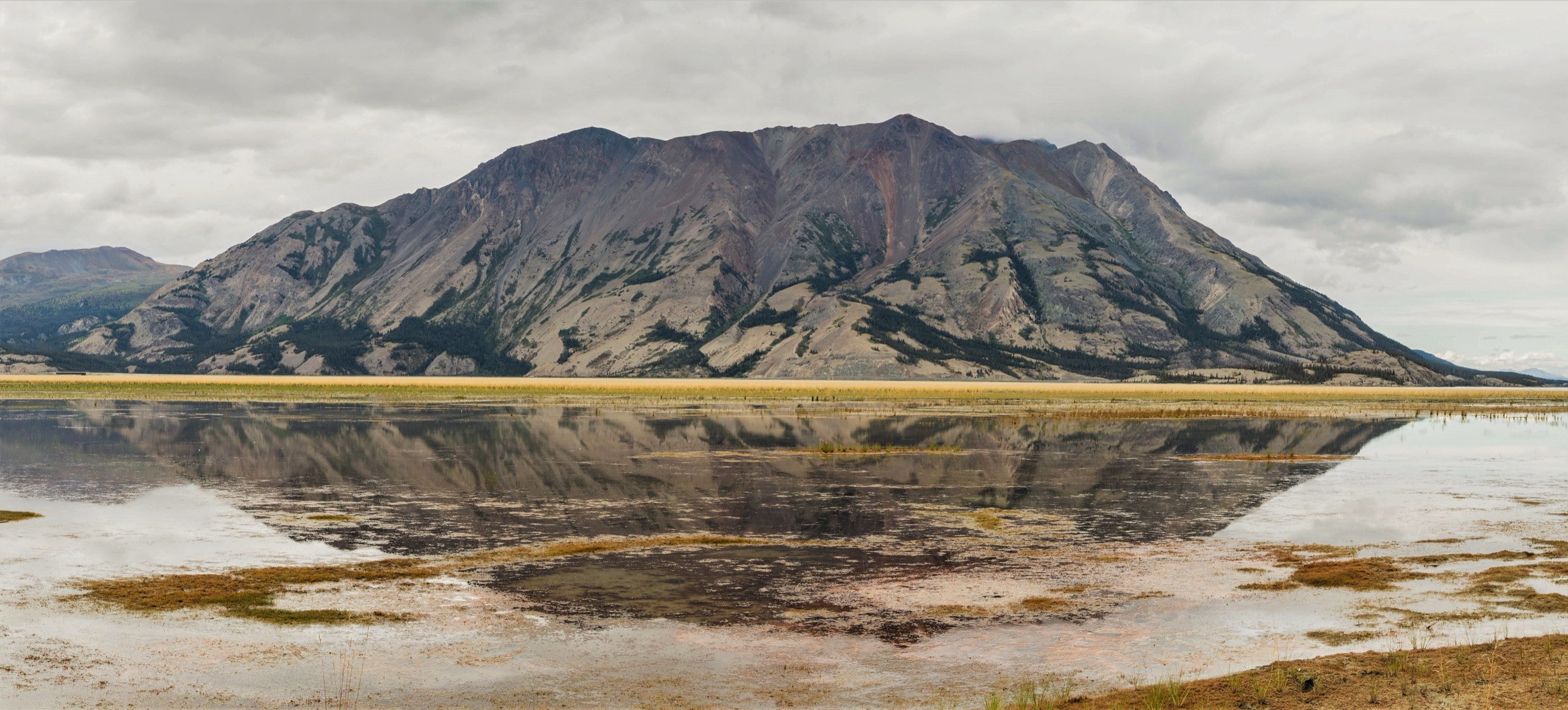
The Ruby Range is a broad, rolling upland in south-western Yukon, running north-west to south-east along the eastern side of Kluane Lake and the Shakwak Trench between Burwash Landing in the north and the Aishihik River / Otter Falls corridor in the south. It is bounded on the west by Kluane Lake and the Alaska Highway, on the south by the Dezadeash and Aishihik river valleys, and on the east by the Aishihik / Hutshi Lakes country. Elevations are typically 800–2,300 m, with the highest summit, Mount Hoge, at roughly 2,709 m. Topographically and geologically the range is sharply distinct from the Kluane Ranges of the St. Elias Mountains on the west side of Kluane Lake: the Ruby Range is characterised by rounded, tundra-covered uplands with treeline slope angles often below 20°, while the Kluane Ranges immediately opposite are steep, rugged and angular. The Ruby Range suite plutons — tonalite and granodiorite of latest Cretaceous to Palaeocene age — form the geological core of the range and host historic copper-molybdenum showings around Killermun Lake and on the Aishihik River.
Almost the entire range lies within the traditional territories of the Kluane First Nation (Burwash Landing, north end) and the Champagne and Aishihik First Nations (Haines Junction and the Aishihik corridor, south end). Kluane National Park and Reserve — jointly managed by Parks Canada with Kluane First Nation and Champagne and Aishihik First Nations — lies on the west side of Kluane Lake and across the Shakwak Trench, and does not include the Ruby Range proper. The Thechàl Dhâl (Sheep Mountain) Visitor Centre on the north shore of Kluane Lake is the closest Parks Canada facility and the standard stop for trail conditions, registration and wildlife information for hikes on the Kluane Lake corridor. Sheep Mountain itself sits across the highway from the Ruby Range and is classified by Parks Canada and the Geographical Names Board of Canada as part of the Saint Elias Mountains / Kluane Ranges, although the boundary at that point follows the Shakwak Trench almost directly below the mountain and some geological literature places its lower slopes on the Ruby edge.
Documented hiking in the Ruby Range is genuinely thin compared with the well-mapped Kluane National Park trails immediately to the west. The best practical day-hikes on the strict Ruby Range side are the Tors plateau loop and short walks on the Aishihik Road corridor (Otter Falls, Canyon Lake, Aishihik Lake Campground). Most of the alpine interior of the Ruby Range is accessed only by float-plane, helicopter or multi-day off-trail expedition; commercial operators (Ruby Range Adventure, Taiga Journeys, Terre Boréale) work the alpine ridges from temporary base camps. Highway-accessible day-hiking is therefore concentrated on the southern Aishihik flank and the Kluane Lake / Burwash Landing corridor. Some of these — particularly Thechàl Dhâl Ridge and Soldier’s Summit — strictly fall on the Kluane Ranges side of the boundary and are included below only as boundary candidates with that allocation explicitly noted.
Best season is mid-June to mid-September. Snow lingers above 1,600 m well into June and returns by late September. Grizzly bear, black bear, Dall’s sheep, mountain caribou, moose and (north of the Aishihik corridor) the re-introduced Aishihik bison herd are all present. The Thechàl Dhâl Ridge area is closed entirely to all human travel during the Dall’s sheep lambing season, 1 May to 15 June, by Parks Canada. Trail conditions, river crossings and bear activity should be verified with the Thechàl Dhâl Visitor Centre (Parks Canada, Kluane National Park) or with Yukon Parks before any trip.
Selection rationale
The five entries below cover: a verified plateau day-hike on the southern Aishihik flank of the Ruby Range proper (The Tors); a verified short interpretive walk to a major Ruby-side waterfall (Otter Falls / Canyon Lake); a boundary-candidate strenuous ridge route at the south-west corner of the Ruby Range / Kluane Ranges contact (Thechàl Dhâl Ridge); a short, accessible interpretive trail at the same junction overlooking Kluane Lake and the Ruby Range across the Shakwak Trench (Soldier’s Summit); and a candidate-only short shoreline walk at the Aishihik Lake Campground on the eastern flank of the Ruby Range. The third and fourth entries are included with explicit range-allocation caveats because the documented day-hike infrastructure on the strict Ruby Range east shore is genuinely sparse, and these two trails are the most directly relevant to anyone visiting the Ruby Range edge from the Alaska Highway. Multi-day Ruby Range alpine traverses from helicopter base-camps in the interior are out of scope.
Summary
| # | Hike | Country | Route type | Distance | Gain | Max elevation | Difficulty |
|---|---|---|---|---|---|---|---|
| 1 | The Tors | Canada | Out-and-back | ~13 km | ~966 m | ~1,800 m | Difficult |
| 2 | Otter Falls and Canyon Lake | Canada | Short out-and-back / loop | ~1–3 km | <50 m | ~660 m | Easy |
| 3 | Thechàl Dhâl (Sheep Mountain) Ridge | Canada | Loop (boundary candidate) | 11 km | 1,310 m | 1,922 m | Strenuous |
| 4 | Soldier’s Summit Trail | Canada | Short out-and-back (boundary candidate) | 1 km | ~90 m | ~870 m | Easy |
| 5 | Aishihik Lake Campground shoreline walk | Canada | Short shoreline walk | ~2–4 km | minimal | ~915 m | Easy |
1. The Tors
Snapshot
Itinerary
The Tors trailhead is reached from the Alaska Highway by turning off about 121 km north of Whitehorse, just before the Otter Falls Cutoff (Aishihik Road) junction. A series of unmarked gravel tracks following the power lines is used to reach the start of the foot route. The trail climbs steeply through boreal forest and willow scrub onto an open shoulder, then continues up a long sub-alpine slope onto a broad tundra plateau. Two clusters of granite tors — weathered free-standing pinnacles up to several metres high — rise out of the tundra on the plateau. Views open eastwards over the Aishihik and Dezadeash valleys towards the Ruby Range interior, and west over the Shakwak Trench to the Auriol and Kluane Front Ranges. Return is by the same route. The published Komoot community recording for the route (“Tour of the tors”) is ~12.1 km with about 4 h 38 min moving time.
Why it is essential
The Tors is the most accessible documented day-hike on the strict Ruby Range side of the Shakwak Trench, on Champagne and Aishihik First Nation settlement land. It is one of very few routes that climbs onto the characteristic rolling tundra-and-granite uplands of the Ruby Range from a road-accessible trailhead, and the tors themselves are a textbook example of the periglacial granite weathering that gives the southern range its distinctive landscape.
Equipment
- Sturdy boots
- Full waterproofs, warm layer
- Hat and gloves outside high summer
- 2–3 L water (no reliable refill on the plateau)
- Map / GPS with backup, headtorch
- Bear spray
- Insect repellent and head net (essential June–August)
Hazards and notes
- The trail is unmarked above the cutline; navigation on the plateau in cloud or mist is non-trivial and the descent line is easy to lose.
- Dall’s sheep, grizzly and black bear are present; follow bear-aware travel guidance from Yukon Parks.
- The route crosses CAFN Category B Settlement Lands; respect CAFN protocols, do not camp on the route without permission, and refrain from removing rocks or disturbing the tors.
- There are no facilities at the trailhead.
- Cell coverage is intermittent below the cutline and absent on the plateau.
Routes and maps
| Source | URL |
|---|---|
| Yukon Hiking — The Tors | yukonhiking.ca |
| Komoot — Tour of the tors (community track) | komoot.com |
| AllTrails — The Torrs | alltrails.com |
| OpenStreetMap — Aishihik Road junction | openstreetmap.org |
External links
- Peakery — The Tors (Castle Rock)
- The Globe Backpacker — Hiking the Tors in Yukon
- Champagne and Aishihik First Nations
2. Otter Falls and Canyon Lake short walks
Snapshot
Itinerary
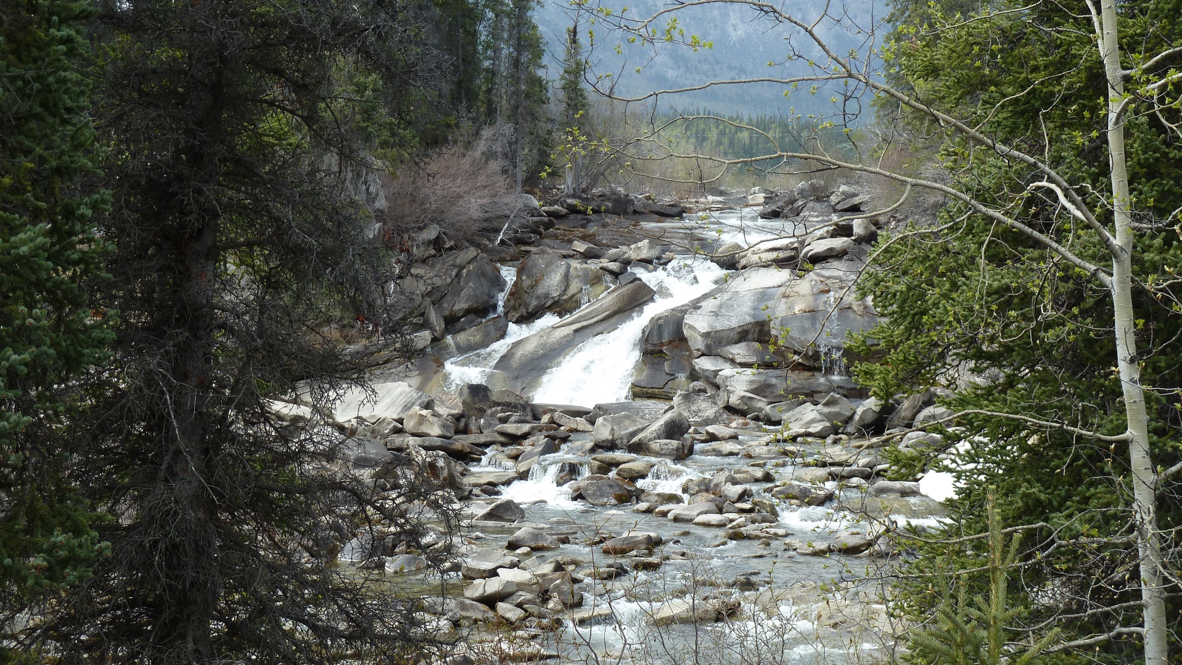
From the Otter Falls Recreation Site car park, a short signed gravel path drops to a viewpoint above Otter Falls (Southern Tutchone: Nadèlin, “water flowing over”) on the Aishihik River. A pull-off about 100 m south of the recreation site provides an alternative access. A second short trail at the adjacent Canyon Lake Recreation Site links the picnic shelter, the lake-shore and the boat launch. The two short walks together make a comfortable 45–90 minute stop. Flows on the Aishihik River above and below the falls are heavily managed by the upstream Aishihik Lake hydroelectric station (Yukon Energy Corporation), and the falls can appear much reduced from their pre-dam state. An engraved view of the falls appeared on the 1954 series Canadian five-dollar banknote.
Why it is essential
This is the most accessible road-and-recreation-site walk on the southern Ruby Range flank and the only short, fully developed visitor walk that opens directly onto the range. It provides a verified, signed introduction to the Aishihik corridor — the gateway to The Tors, the Aishihik Lake bison range and the western Ruby Range — and connects the geography of the range to the cultural and industrial history of the Aishihik River.
Equipment
- Day-walking shoes
- Layers
- Sun and insect protection
- Picnic facilities and outhouse at both recreation sites; no drinking water on site outside the campground season
Hazards and notes
- Rocks immediately below the falls are slippery and the river bank is steep; keep behind any railings and signage.
- The Recreation Site gates are closed daily from 23:00 to 07:00.
- The Aishihik Road is unpaved beyond the recreation site and rough sections begin past km 27.
- Bear-aware travel guidance applies. The site is within CAFN traditional territory and is co-managed under the Yukon Parks recreation-site system.
Routes and maps
| Source | URL |
|---|---|
| Yukon government — Otter Falls Recreation Site | yukon.ca |
| OpenStreetMap — Otter Falls Recreation Site | openstreetmap.org |
External links
- Yukon Place Names — Otter Falls (Nadèlin)
- Wikipedia — Otter Falls (Yukon)
- ExploreNorth — Exploring the Aishihik Road and Otter Falls
3. Thechàl Dhâl (Sheep Mountain) Ridge
Snapshot
Itinerary
The route starts at the boat-launch parking area immediately north of the Thechàl Dhâl Visitor Centre and climbs the steep North-East Ridge directly above the Alaska Highway. The first 2.5 km gains roughly 1,310 m off-trail on a broad, rocky shoulder with sustained scrambling — no technical climbing, but unrelenting effort. The ridge crest tops out at about 1,922 m with a 360° panorama: Kluane Lake and the rolling Ruby Range to the east across the Shakwak Trench, the Slims River valley to the south-west, and the icefield ranges of the central Saint Elias beyond. The descent traverses west along the ridge to join the upper Sheep Creek Trail, which drops gradually back to the Visitor Centre via the established Sheep Creek route. Parks Canada describes this as a loop and recommends doing it in this direction.
Why it is essential
Thechàl Dhâl Ridge is the only strenuous day-hike from a developed Alaska Highway trailhead with a near-complete summit panorama of the Ruby Range across the Shakwak Trench. Although the mountain itself is officially classified by Parks Canada as part of the Saint Elias Mountains / Kluane Ranges, the geological contact between the two ranges lies almost directly below it; for any visitor trying to understand the Ruby Range in context, this is the single most informative summit. The Sheep Creek leg is also a documented Kluane National Park trail and includes Parks Canada interpretive material on the Kluane First Nation and Champagne and Aishihik First Nations co-management of the area.
Equipment
- Sturdy boots
- Full waterproofs, warm layers, hat and gloves
- 2–3 L water (no water above 1,000 m), food
- Headtorch, bear spray
- Map (NTS 115 G/2 Mount St Elias and Kluane National Park brochures), GPS
- Self-registration may apply for the Sheep Creek leg; check at the Thechàl Dhâl Visitor Centre
Hazards and notes
- All travel within the Thechàl Dhâl Ridge area is prohibited from 1 May to 15 June each year to protect Dall’s sheep during lambing — this closure is enforced.
- Grizzly and Dall’s sheep are present; the route descends through prime sheep habitat.
- The ridge is fully exposed to wind and lightning.
- Loose rock and steep tundra make a slip on descent the principal hazard.
- The Visitor Centre at Thechàl Dhâl should be the first stop for current conditions, registration and bear activity.
- Range allocation: Parks Canada and Wikipedia place this trail in the Kluane Ranges; the entry is retained here as a boundary candidate because it is the single most useful Ruby Range viewpoint from a public trail.
Routes and maps
| Source | URL |
|---|---|
| Parks Canada — Thechàl Dhâl (Sheep Mountain) Ridge | parks.canada.ca |
| Yukon Hiking — Thechàl Dhâl (Sheep Mountain) | yukonhiking.ca |
| OpenStreetMap — Thechàl Dhâl area | openstreetmap.org |
External links
- Wikipedia — Sheep Mountain (Yukon)
- Live Small | Ride Free — Tachal Dhal Ridge Trail
- The Outbound — Summit Sheep Mountain (Tachäl Dhäl)
4. Soldier’s Summit Trail
Snapshot
Itinerary
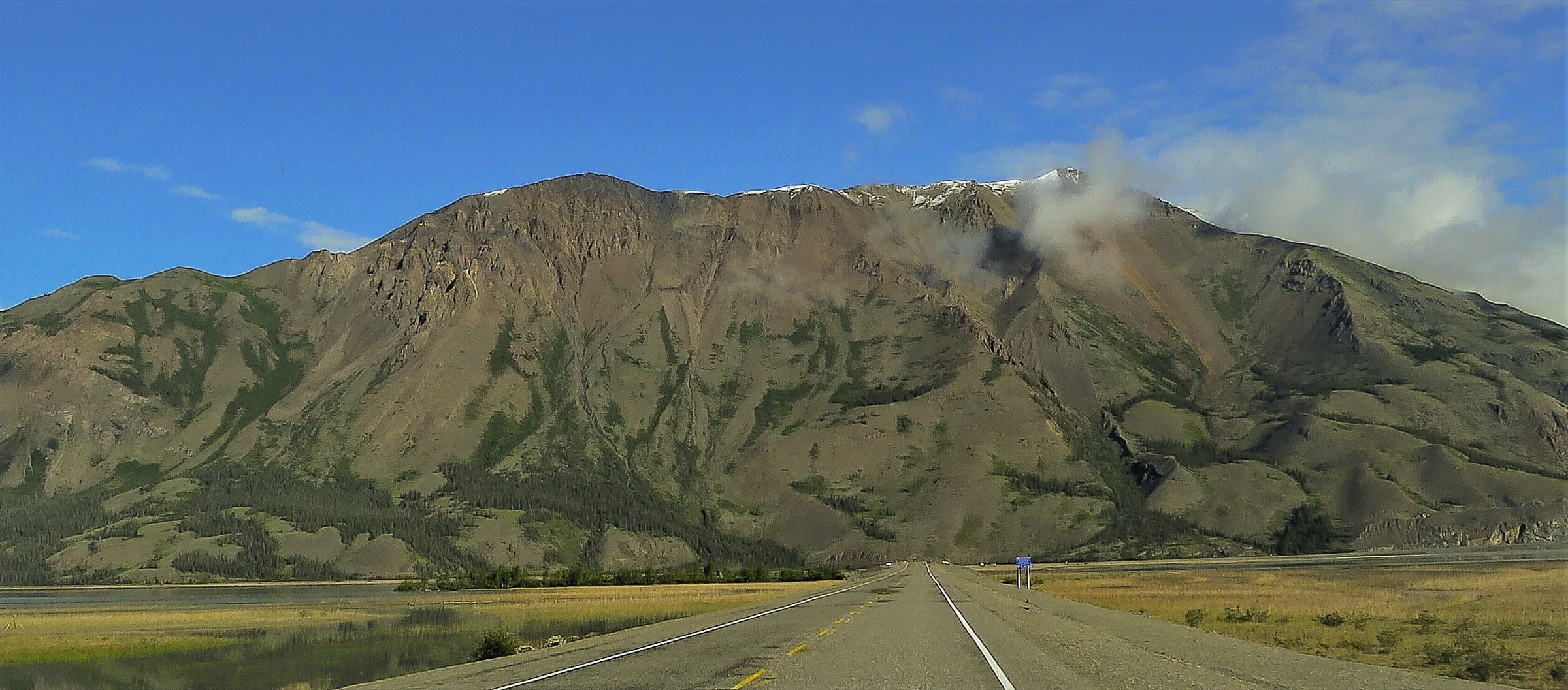
The trail leaves the small Soldier’s Summit car park at the edge of the Alaska Highway, follows the alignment of the original 1942 “pioneer road” up a gentle climb of about 90 m, and reaches a viewing platform with replica flags and interpretive panels marking the site of the formal opening of the Alaska Highway on 20 November 1942. The panels include Kluane First Nation and Champagne and Aishihik First Nations interpretive material on the impact of the highway’s construction on Yukon First Nations. The viewing platform overlooks the south end of Kluane Lake and looks directly across the Shakwak Trench to the rolling western flank of the Ruby Range — the trail is the most accessible Alaska Highway viewpoint of the Ruby Range proper.
Why it is essential
Soldier’s Summit is the only short, fully signed and interpreted day-walk in the immediate area that opens onto a direct view of the Ruby Range east shore and the south end of Kluane Lake from the Alaska Highway. It functions as the gateway interpretive walk to the Kluane / Ruby junction and pairs the geology of the range with the cultural and political history of the highway’s construction.
Equipment
- Day-walking shoes
- Layers, water
- Interpretive panels and benches along the route
- Pets allowed on leash per Parks Canada rules
Hazards and notes
- Dall’s sheep are often seen at and below the trail, particularly in spring and early summer.
- The trail itself remains open during the 1 May – 15 June Thechàl Dhâl Ridge closure (the closure applies to the off-trail ridge area, not the interpretive trail), but signage should be checked on arrival.
- Grizzly activity is reported in the area; bear-aware travel guidance applies.
- The viewing platform is exposed to wind off the lake.
Routes and maps
| Source | URL |
|---|---|
| Parks Canada — Soldier’s Summit Trail | parks.canada.ca |
| Yukon government — Soldier’s Summit Trail | yukon.ca |
| OpenStreetMap — Soldier’s Summit | openstreetmap.org |
External links
- Canada.ca — Parks Canada celebrates 75th anniversary of the Alaska Highway at Soldier’s Summit
- ExploreNorth — The Soldier’s Summit Trail: A History Guide
- Our Alaska Highway — Soldier’s Summit
5. Aishihik Lake Campground shoreline walk
Snapshot
Itinerary
From the campground at the south end of Aishihik Lake (Äshèyi Män, “at the end of the mountain range” in Southern Tutchone), informal walking is possible along the lakeshore and on access tracks linking the boat launches, picnic shelter and dock. There is no formal hiking trail at the campground; the value of the visit is the position of the site directly below the eastern Ruby Range slopes, with views westwards across the lake to the lower Ruby Range alpine. Wildlife in the immediate area includes the re-introduced Aishihik bison herd, which uses the lake corridor seasonally. The drive in from the Alaska Highway via the Aishihik Road passes Otter Falls (Hike 2), the Aishihik River canyon and several small lakes; the Yukon government only maintains the road as far as the campground. The active CAFN settlement at Äshèyi village at the north end of the lake is accessed only on foot, by boat or by the maintained-track portion of the road.
Why it is essential
This is the most accessible developed-site walk on the south-eastern flank of the Ruby Range, and the only Yukon Parks campground on the range itself. It allows visitors to make a credible road-accessible introduction to the rolling Ruby Range east of Kluane Lake, with bison-range interpretation and direct line-of-sight on the lower Ruby Range alpine.
Equipment
- Day-walking shoes
- Layers, sun and insect protection (mosquitoes and horse-flies are abundant in summer)
- Bear spray, water
- Campground facilities: outhouses, picnic shelters, two boat launches, a dock and wheelchair-accessible facilities; no potable water tap confirmed
Hazards and notes
- Bison are present and can be aggressive; keep at least 100 m clear.
- The Aishihik Road is unpaved and rough beyond Otter Falls; check road conditions with Yukon government before driving the full distance.
- There is no cell coverage on most of the road.
- The site lies within CAFN traditional territory; respect CAFN protocols and do not enter the Äshèyi village area at the north end of the lake without permission.
- The lake is exposed to wind off the Ruby Range and can become rough within minutes.
Routes and maps
| Source | URL |
|---|---|
| Yukon government — Aishihik Lake Campground | yukon.ca |
| OpenStreetMap — Aishihik Lake Campground | openstreetmap.org |