Regional overview
The Waterton and Southern Rockies area occupies the south-western corner of Alberta where the Canadian Rocky Mountain Front collides abruptly with the prairie. Unlike Banff or Jasper, the transition here is sudden — windswept fescue grassland gives way to 2,500-metre quartzite and argillite peaks within a single field of view. The region sits at the heart of the Crown of the Continent ecosystem and, together with Glacier National Park (Montana) to the south, forms the Waterton-Glacier International Peace Park, a UNESCO World Heritage Site. The major hiking centres are Waterton townsite (Waterton Lakes National Park), the Akamina Parkway and Red Rock Parkway corridors inside the park, Castle Provincial Park and Wild Land north-west of Waterton, and the Crowsnest Pass communities (Blairmore, Frank, Bellevue) along Highway 3.
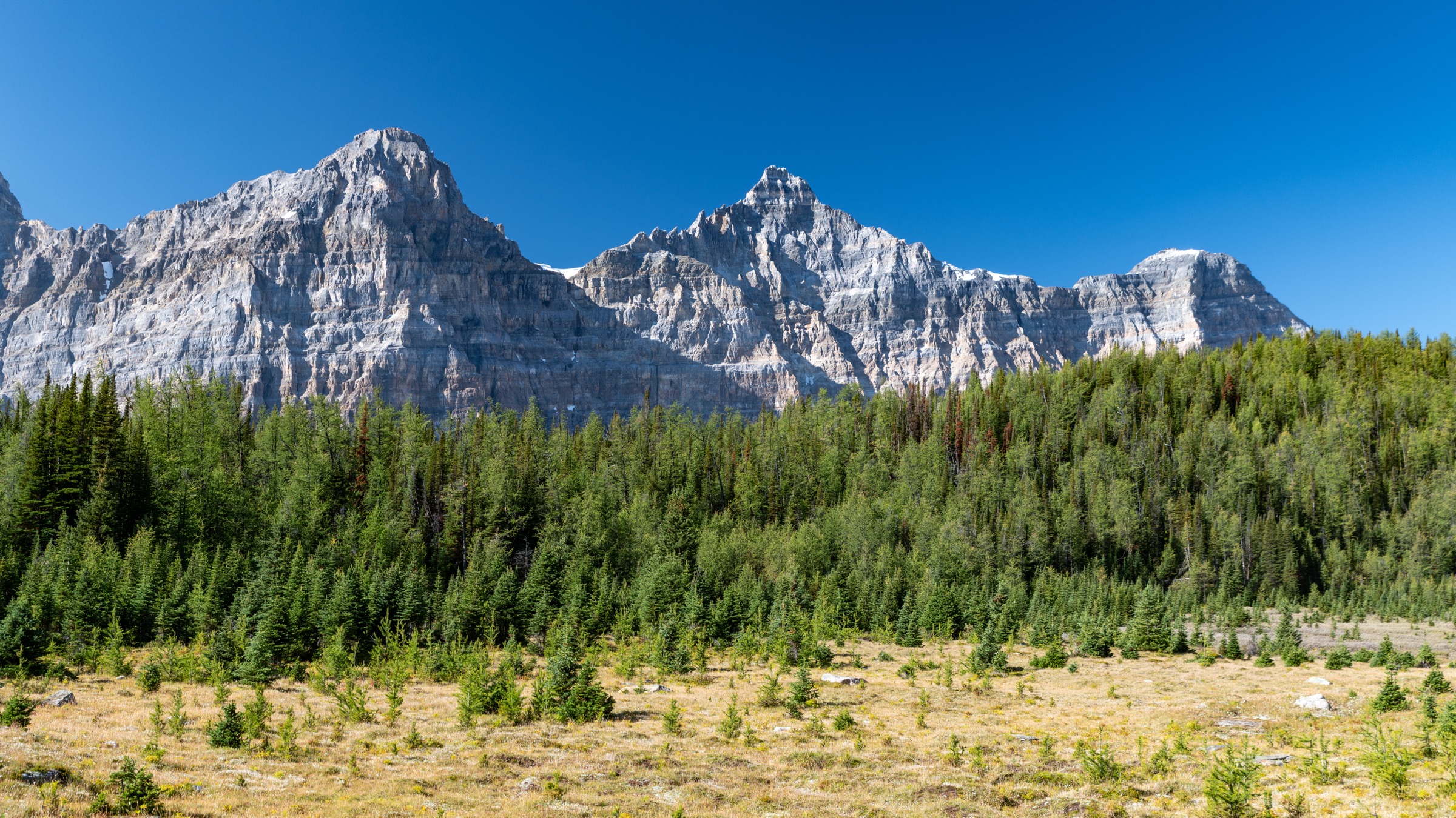
Terrain is varied: glacially-scoured cirques and turquoise lakes (Crypt, Bertha, Cameron, Wall, Forum), narrow alpine ridges with views straight into Montana, and the Lewis Thrust geology that pushes ancient Precambrian rock over much younger material. Trails range from a 40-minute switchback to the Bear’s Hump viewpoint over Waterton townsite up to long traverses on the Great Divide Trail. The hiking season runs roughly mid-June to mid-October at trail level; ridges and passes hold snow well into July and ice can re-form on shaded sections of the Crypt Lake Trail by late September. Wind is the defining weather feature — Waterton townsite regularly records sustained 70–90 km/h gusts and exposed ridge sections become genuinely dangerous on storm days.
The September 2017 Kenow Wildfire is the single most important context for trail planning here. The fire burned approximately 19,300 hectares within Waterton Lakes National Park — close to 39 % of the park area — and damaged or destroyed an estimated 80 % of the park’s trail network. Vegetation recovery is well advanced (young aspen, fireweed, huckleberry and Saskatoon berry have replaced the previous conifer canopy through most burned zones), but practical consequences remain: limited shade, deadfall hazard on windy days, and faster blow-down cycles on rebuilt trails. Parks Canada has reopened most signature trails, including Bear’s Hump (reopened 2020 after a complete rebuild), Bertha Falls and Bertha Lake, the Crandell Lake Loop and the Carthew-Alderson traverse. Crypt Lake and the Wishbone / Vimy Peak area on the east side of Upper Waterton Lake escaped the burn. Check the Parks Canada trail-conditions page before any trip; early-season snow and trail-work closures are common.
Safety priorities are grizzly bear country protocols (bear spray on hip, group of four where practical, voice in dense vegetation — both grizzly and black bears are present and densities are among the highest in the Rockies relative to park area), exposure on the burn-scar trails (no shade, no water), and the wind. Cell coverage is intermittent away from townsite and Highway 3. Park entry requires a Parks Canada day or annual pass; Castle Provincial Park is free; Crowsnest Pass summits are on municipal or provincial land with open access.
Selection rationale
The five chosen hikes cover the canonical experience set for this corner of the Rockies. Crypt Lake is the iconic adventure day-hike, combining a boat shuttle, a tunnel, cables and a hanging-valley lake. The Carthew-Alderson traverse is the long alpine-pass classic and the best single-day view of the region’s geology. Akamina Ridge crosses briefly into British Columbia and delivers the ridge / scramble entry with two lakes for the loop. Bertha Lake represents the accessible moderate-day archetype and shows post-Kenow recovery first-hand. Turtle Mountain in Crowsnest Pass provides the cultural and historical summit — looking down on the 1903 Frank Slide debris field. Together they span boat-access adventure, traverse, ridge loop, lake walk and historic summit, and use four distinct trailheads on three different access roads.
Summary table
| # | Hike | Country | Route type | Distance | Gain | Max elevation | Difficulty |
|---|---|---|---|---|---|---|---|
| 1 | Crypt Lake Trail | Canada | Boat-access out-and-back | 17.2 km | 675–700 m | 1,985 m | Difficult |
| 2 | Carthew–Alderson Traverse | Canada | One-way, shuttle | 19.2–20.1 km | 650 m | 2,311 m | Difficult |
| 3 | Akamina Ridge Loop | Canada (AB → BC) | Loop | 18.2 km | 905 m | 2,600 m | Difficult |
| 4 | Bertha Lake | Canada | Out-and-back | 10.4 km | 460 m | 1,750 m | Moderate |
| 5 | Turtle Mountain (North Peak) | Canada | Out-and-back | 6.0–7.2 km | 820–930 m | 2,210 m | Difficult |
1. Crypt Lake Trail
Snapshot
Itinerary
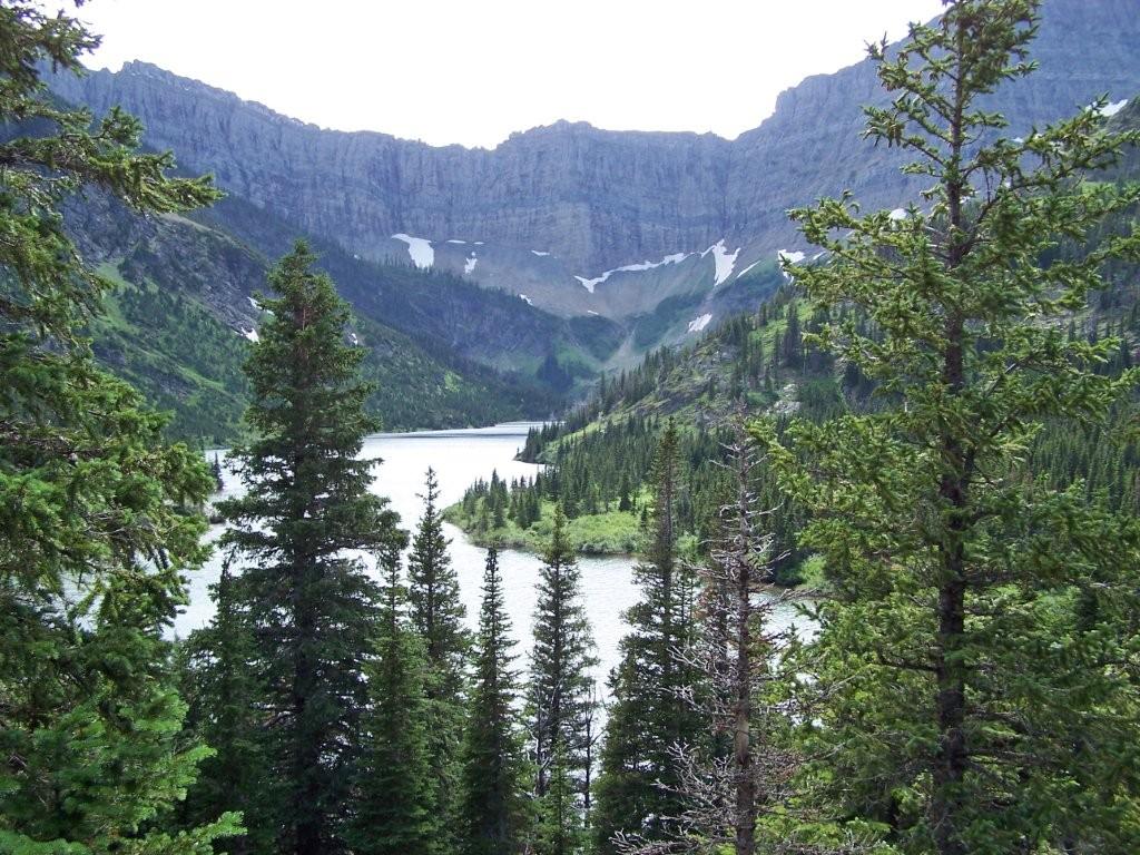
The route begins at Crypt Landing on the east shore of Upper Waterton Lake, reached only by the Waterton Inter-Nation Shoreline Cruise Co. shuttle. From the dock the trail climbs steadily through subalpine forest on the lower slopes of Mount Boswell, gaining about 300 m through a series of well-graded switchbacks. A signed spur leads in about 1 km to Hell-Roaring Falls and Hell-Roaring Canyon, an optional side-trip on the return if the boat schedule allows. The main trail continues up and around into the hanging valley that holds the upper drainage, passing Twin Falls at roughly 3.5 km and Burnt Rock Falls at about 5.6 km.
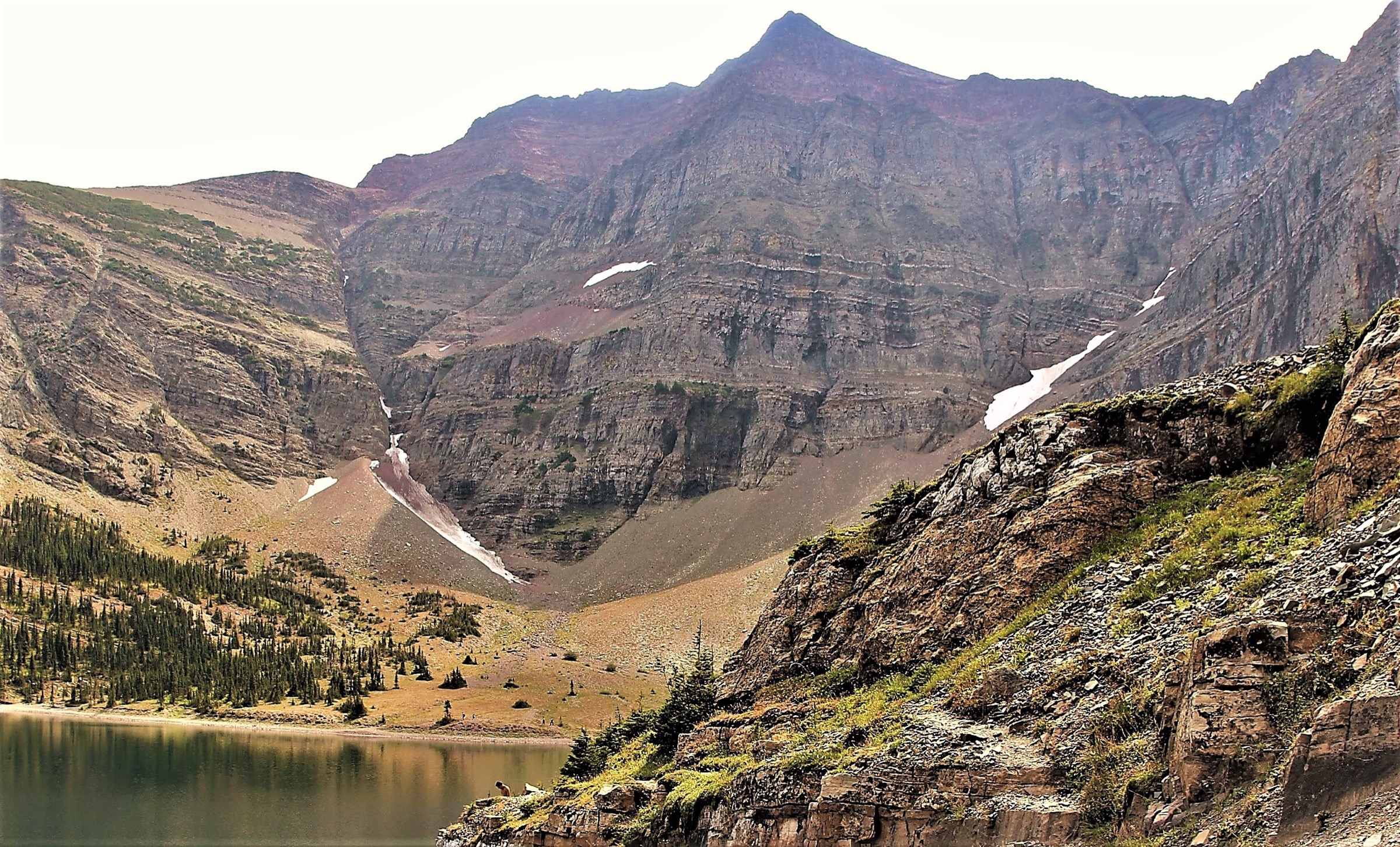
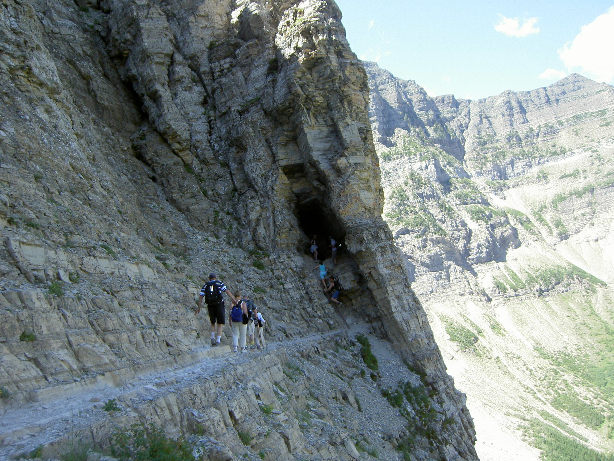
Above Burnt Rock Falls the forest thins and the trail traverses an open argillite basin beneath the cirque walls. The decommissioned Crypt Lake backcountry campground sits in the basin floor; the route swings left and begins the crux. A ledge approximately 50 cm wide cuts across the cliff for a short distance, then a fixed steel ladder ascends about 3 m to the mouth of a low natural rock tunnel. The tunnel is roughly 20–30 m long, low enough that most hikers crawl, and exits onto an exposed traverse where a fixed steel cable provides hand support across a sloping rock slab. A short scramble through krummholz then drops to the outlet of Crypt Lake at the base of Crypt Falls. The lake itself sits in a glacially-cut cirque immediately below the international boundary — the south shore is in Montana, and a faint trail follows the shoreline to the boundary cut. Return is by the same route; hikers must be back at Crypt Landing for the scheduled pickup.
Why it is essential
Crypt Lake is Waterton’s signature trail and was voted Canada’s Best Hike by readers of Explore Magazine in 1981 — a status that has stuck. The combination of boat access, four named waterfalls, the cable-tunnel-ladder crux and a cirque lake on the international border is unique in the Canadian Rockies. The trail also escaped the 2017 Kenow Wildfire entirely, so the forest cover and stream corridors are intact.
Equipment
- Standard day-hike kit
- Headlamp for the tunnel (hands-free useful for crawling)
- Gloves for the cable section
- Bear spray on hip
- Several litres of water (no reliable potable source)
- Wind shell for the lake basin
- Boat ticket booked in advance
Hazards and notes
Grizzly and black bear habitat throughout. The cable and ladder sections are not technically difficult but expose to a fall of several metres; hikers with significant vertigo should think carefully. Ice can persist in the tunnel into July and re-form in September; micro-spikes are sometimes useful at shoulder season. Wind funnels through the upper basin. The lake water is glacially cold — swimming is brief and shocking. The international border is unmonitored at the lake’s south shore but legally is not an authorised crossing point. Missing the afternoon pickup means a long unsanctioned walk around the head of the lake or an emergency call-out.
GPX / KML links
| Source | URL | Format | Notes |
|---|---|---|---|
| OpenStreetMap | openstreetmap.org | OSM data (export GPX) | ODbL 1.0; reusable with attribution |
| AllTrails — Crypt Lake Trail | alltrails.com | GPX (account) | AllTrails ToS — personal use only |
| Parks Canada | parks.canada.ca | Source page | No published GPX |
Sources
- Parks Canada — Day hikes in Waterton
- Parks Canada — Trail conditions
- Wikipedia — Crypt Lake Trail
- Waterton Inter-Nation Shoreline Cruise (2026 schedule)
- Waterton Tourism — Crypt Lake
2. Carthew–Alderson Traverse

Snapshot
Itinerary
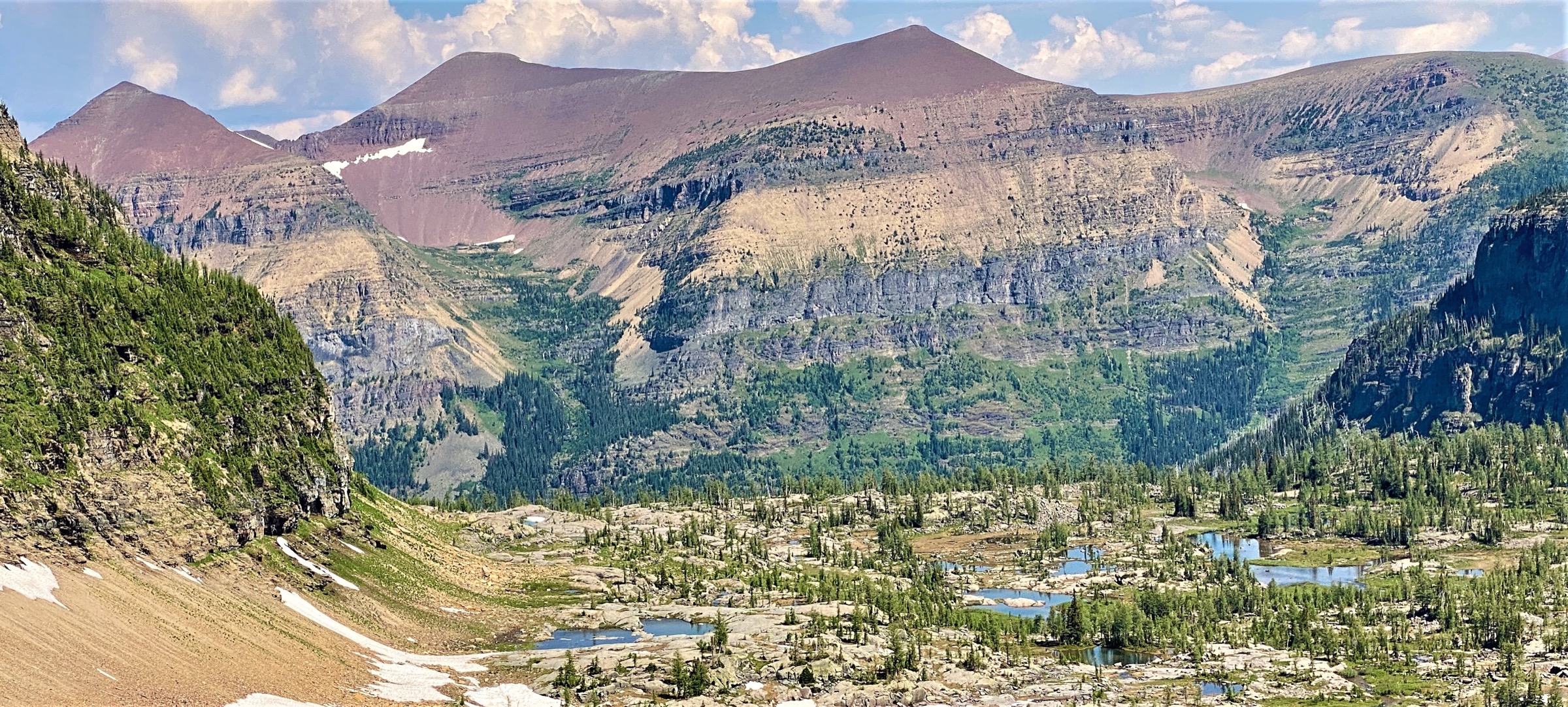
From Cameron Lake the trail climbs steadily north through subalpine forest to Summit Lake (2.5 km, the only protected lunch spot before tree line if weather turns). From Summit Lake a junction sends the Boundary Creek Trail west toward the international boundary; the Carthew route instead bears east and climbs onto open scree slopes. The grade eases briefly at the Carthew Lakes — two small alpine tarns set in a stark red-and-orange argillite basin — and then re-steepens to Carthew Summit (~2,311 m), a broad saddle with views south into Glacier National Park (Montana), east to the prairie edge, and north into the Castle ranges.
The descent drops north-east into the Alderson Lake cirque, losing about 350 m on switchbacks to the lake. From Alderson Lake the trail enters the Carthew Creek valley, much of which was burned in the 2017 Kenow Wildfire. The next 8 km descend gradually through regenerating aspen, fireweed and exposed standing snags down to Cameron Falls at the south end of Waterton townsite. Parks Canada has repaired the lookouts and the burned sections of the lower trail. There is no shade for the final third of the route — start early in hot weather.
Why it is essential
The Carthew-Alderson is one of Waterton’s Triple Crown hikes and the most complete single-day cross-section of park geology: glacial cirques, red argillite at Carthew Lakes, an alpine col on the continental divide of climate, and a long descent through Kenow fire regeneration. It is also part of the Great Divide Trail.
Equipment
- Day-hike kit
- Two trekking poles (long descent)
- Sun protection (no shade above Summit Lake or below Alderson Lake)
- Bear spray
- 2–3 L water (sources between Summit Lake and Alderson Lake are limited)
- Wind shell
- Shuttle ticket purchased in advance
Hazards and notes
Lightning exposure on the open kilometre between the Carthew Lakes and the summit — turn back in approaching storms. Wind on the summit is frequently 60+ km/h. Bear activity on the regenerating Carthew Creek descent is moderate to high in berry season (late July–September). The lower forest has standing fire-killed timber that drops in wind events; avoid in high wind. Cell signal is intermittent.
GPX / KML links
| Source | URL | Format | Notes |
|---|---|---|---|
| Great Divide Trail Association | greatdividetrail.com | KML / GPX (Section A) | Free for personal use; check site terms |
| OpenStreetMap | openstreetmap.org | OSM data (export GPX) | ODbL 1.0; reusable with attribution |
| Strava route | strava.com | GPX (account) | Strava terms |
Sources
- Parks Canada — Day hikes in Waterton
- Wikipedia — Mount Carthew
- 10Adventures — Carthew-Alderson
- Great Divide Trail Association — Carthew-Alderson traverse
- Tamarack Outdoors hiker shuttle
3. Akamina Ridge Loop (via Forum and Wall Lakes)
Snapshot
Itinerary
The route starts at the Akamina Pass trailhead on the Akamina Parkway. A maintained track climbs 1.5 km to Akamina Pass (1,780 m), crossing from Alberta into British Columbia and into Akamina-Kishinena Provincial Park. At the pass the loop direction is a matter of preference; the conventional anticlockwise direction turns left (south-west) on the Forum Lake spur, climbing through subalpine forest to Forum Lake in a steep cirque beneath Akamina Ridge (~2.5 km from the pass).
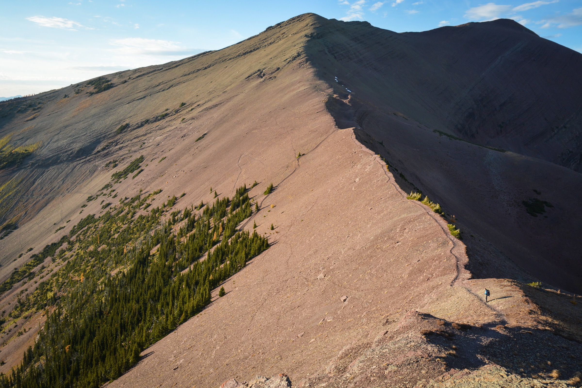
From the south-east corner of Forum Lake a steep climber’s trail ascends the cirque headwall — about 400 m of gain in roughly 1 km, with loose scree and easy hands-on scrambling near the top — to gain the crest of Akamina Ridge. The ridge proper runs roughly 5 km west-north-west along the BC–Montana border, with the high point near 2,600 m. Views drop south into Glacier National Park (Kintla Lake basin) and north into the Waterton lakes. Exposure is mostly modest but a few short narrow sections require care.
The ridge descends to Brenner Pass, where a marked descent route drops north to Wall Lake. Wall Lake itself is a long blue-water lake under a sheer wall — the descent rejoins the main Wall Lake Trail. From Wall Lake the loop returns east to Akamina Pass and back down to the trailhead, completing roughly 18 km.
Why it is essential
Akamina Ridge is the area’s best ridge-walk and the only practical day-hike option to combine two alpine lakes and a 5 km traverse above 2,400 m. The crossing into BC and into Akamina-Kishinena Provincial Park — one of the least-visited parks in the BC system — adds a different management context and a noticeable drop in foot traffic compared with the Waterton-side trails.
Equipment
- Trekking poles
- Helmet optional but recommended for the Forum Lake headwall (loose rock above)
- Bear spray
- 3 L water (none on the ridge)
- Wind shell and warm layer
- Sun protection
Hazards and notes
Cornices on the north side of the ridge persist into mid-summer and have given way under hikers; stay back from the edge. Lightning exposure is total along the ridge. Grizzly bear habitat throughout Akamina-Kishinena. Snow patches on the descent off Brenner Pass to Wall Lake can be steep and icy in early season; an ice axe is occasionally warranted. The international border runs along the ridge crest — straying south is technically a border violation but the boundary is unmarked here. The route should not be attempted in marginal weather; the ridge has no escape routes between Forum and Brenner Pass.
GPX / KML links
| Source | URL | Format | Notes |
|---|---|---|---|
| Trailforks | trailforks.com | GPX (account) | Trailforks terms |
| AllTrails | alltrails.com | GPX (account) | AllTrails terms |
| OpenStreetMap | openstreetmap.org | OSM data (export GPX) | ODbL 1.0; reusable with attribution |
Sources
- BC Parks — Akamina-Kishinena Park
- PeakVisor — Akamina-Kishinena Provincial Park
- Wikipedia — Akamina Ridge
- Bob Spirko trip report — Akamina Ridge / Forum Peak
- Experience Waterton — Akamina Ridge
4. Bertha Lake
Snapshot
Itinerary
The trail leaves the Evergreen South parking lot just south of Cameron Falls in Waterton townsite. For the first 1.5 km it follows the wooded shoreline of Upper Waterton Lake on a gently graded path; a signed junction at 1.5 km marks where the Bertha route splits left and climbs into the Bertha Creek drainage. A switchback section gains a viewpoint of Upper Bertha Falls at about 2.5 km. The trail continues on the south side of Bertha Creek to Lower Bertha Falls (~2.9 km) — a popular short turnaround for visitors who do not want the climb to the lake.
Above Lower Bertha Falls the grade increases sharply. The trail switchbacks up the west wall of the cirque, passing close to Upper Bertha Falls, and tops out at the outlet of Bertha Lake (~5.2 km, ~1,750 m). The lake sits in a glacial cirque ringed by Mount Richards, Mount Alderson and Bertha Peak. A 5 km perimeter trail circles the lake, adding an easy hour if desired. Return is by the same route.
Why it is essential
Bertha Lake is the accessible half-day classic of Waterton — walkable from the townsite, a good introduction to the park’s geology, and a useful first-hand look at post-Kenow recovery in the lower forest sections. The trail was burned in 2017 and rebuilt as part of the first wave of Parks Canada’s post-fire trail programme, reopening in 2018.
Equipment
- Standard day-hike kit
- Bear spray
- 1.5–2 L water
- Sun protection (canopy is patchy through the regenerating sections)
- Swimming gear if planning a cold lake plunge
Hazards and notes
Black bear and occasional grizzly activity throughout, especially in berry season on the regenerating slopes. Standing fire-killed timber along sections of the lower trail — avoid in high wind. The lake itself is cold even in August. Trailhead parking fills early on summer weekends; arrive before 09:00 or expect to walk in from townsite.
GPX / KML links
| Source | URL | Format | Notes |
|---|---|---|---|
| OpenStreetMap | openstreetmap.org | OSM data (export GPX) | ODbL 1.0; reusable with attribution |
| AllTrails | alltrails.com | GPX (account) | AllTrails terms |
| Parks Canada | parks.canada.ca | Source page | No published GPX |
Sources
- Parks Canada — Day hikes in Waterton
- Waterton Tourism — Bertha Lake
- A Walk and a Lark — Bertha Lake
- CBC News — Bear’s Hump / Bertha rebuild context
5. Turtle Mountain (North Peak), Crowsnest Pass
Snapshot
Itinerary
The standard route to Turtle Mountain’s North Peak starts in a residential subdivision in Blairmore, one of the communities of the Municipality of Crowsnest Pass. From the end of 15th Avenue, a rough back-alley track leads to a small dirt parking area under a power line; the trailhead is unsigned but marked with yellow-painted rocks just before a chain-link fence at an old quarry. The trail climbs steeply from the first metres up the north-west shoulder of Turtle Mountain through aspen and pine, with several rough sections of loose scree and root steps.
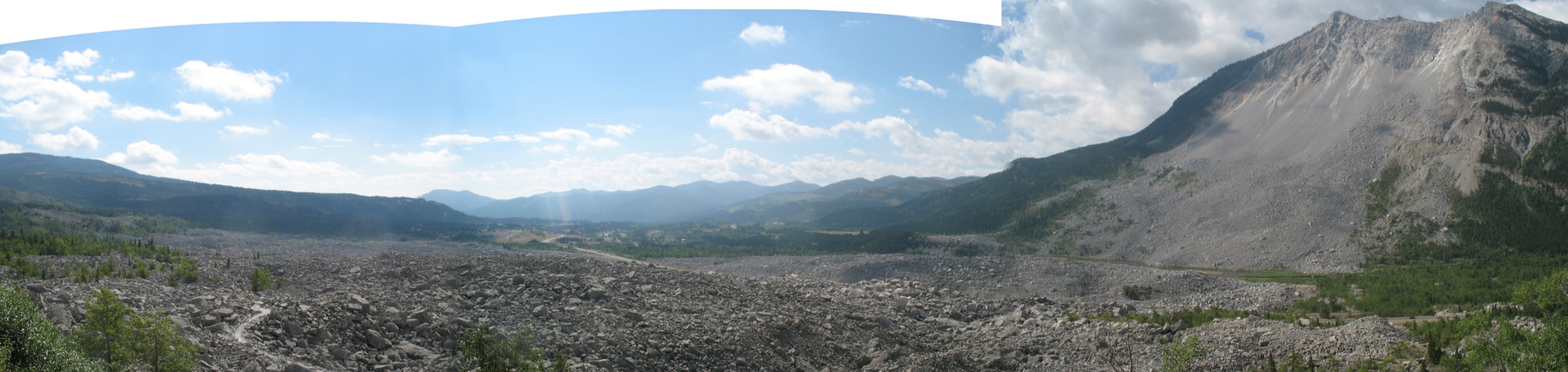
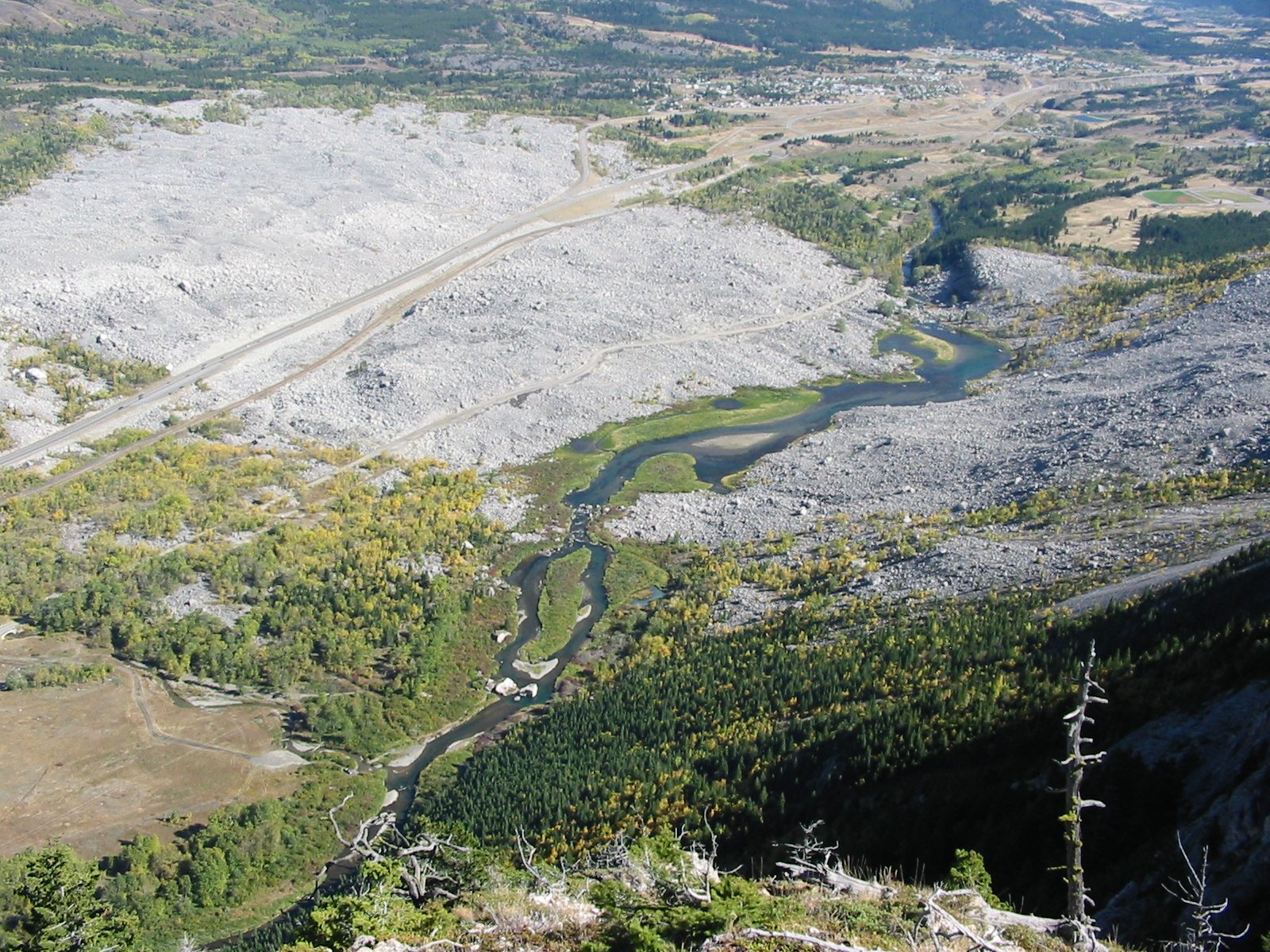
After about 2 km the gradient eases briefly and the route emerges onto open ridge with the first views west into the Crowsnest valley. Three successive false summits lead to a final short rock scramble on broken limestone to the North Peak (2,100 m). The summit looks directly down on the debris field of the 1903 Frank Slide — 30 million cubic metres of rock that detached from the upper east face of the mountain and buried the south end of the town of Frank, killing roughly 70–90 people. The Alberta Geological Survey maintains a real-time monitoring system on the summit ridge; instrumentation is visible. Continuing south along the ridge to the true (South) Peak at 2,210 m adds approximately 2 km and 110 m of gain over broken terrain and passes the main monitoring station — sensible only for experienced scramblers. Most parties turn back at the North Peak.
Why it is essential
Turtle Mountain is the cultural summit of the southern Canadian Rockies. The hike combines a serious 800-metre vertical day with a direct view onto Canada’s deadliest rockslide and onto the active monitoring programme that has tracked the south peak’s continued movement since 2003. Blackfoot and Ktunaxa oral traditions referred to it as “the mountain that moves” — a name justified by the 1903 event and by ongoing geophysical creep.
Equipment
- Trekking poles for the descent
- Bear spray
- Helmet recommended for the upper scramble (loose rock)
- 2–3 L water (no source on route)
- Sun protection
- Wind shell
Hazards and notes
The upper mountain is geologically unstable; the south peak is actively monitored for continuing slope creep. Stay on established lines and do not disturb monitoring equipment. Loose rock on the ridge requires care when parties are above one another. Black bear and occasional grizzly activity in the lower forest. The trailhead is in a residential area — park respectfully, no overnight parking. Lightning exposure is severe on the upper ridge. The exposed limestone is slippery when wet — avoid in rain.
GPX / KML links
| Source | URL | Format | Notes |
|---|---|---|---|
| Trailforks | trailforks.com | GPX (account) | Trailforks terms |
| Komoot | komoot.com | GPX (account) | Komoot terms |
| OpenStreetMap | openstreetmap.org | OSM data (export GPX) | ODbL 1.0; reusable with attribution |
Sources
- Wikipedia — Turtle Mountain (Alberta)
- Trailforks — Turtle Mountain Hike
- Monkeys and Mountains — Turtle Mountain hike guide
- Crowsnest Heritage — Heritage Trails
- Hike Bike Travel — 5 Best Crowsnest Pass Hikes
External links
| Source | URL |
|---|---|
| Parks Canada — Waterton Lakes National Park activity hub | parks.canada.ca |
| Parks Canada — Day hikes | parks.canada.ca |
| Parks Canada — Trail conditions | parks.canada.ca |
| BC Parks — Akamina-Kishinena Park | bcparks.ca |
| Waterton Inter-Nation Shoreline Cruise Co. (2026 boat schedule) | watertoncruise.com |
| Tamarack Outdoors — hiker shuttle | hikewaterton.com |
| Waterton Tourism — listings | watertontourism.com |
| CBC News — Five years after Kenow Wildfire | cbc.ca |
| Canadian Rockies Trail Guide — post-wildfire recovery | canadianrockiestrailguide.com |
| Wikimedia Commons — Waterton Lakes National Park category | commons.wikimedia.org |