Regional overview
The Chic-Choc Mountains form the high, cold, exposed backbone of the Gaspé Peninsula. The essential walking character is a mix of boreal forest, alpine tundra, cirques, broad summit plateaux, and sudden weather changes. The most reliable concentration of maintained day hikes is in Parc national de la Gaspésie, with additional routes extending into the surrounding wildlife reserve and International Appalachian Trail corridor.
The main hiking base is the Mont-Albert sector of Parc national de la Gaspésie, reached by Route 299. Mont Jacques-Cartier and the McGerrigle sector require close attention to shuttle access, opening windows, caribou-related restrictions, and seasonal trail closures. The usual hiking season is short: many higher routes open only from mid-June or July and close by late September or mid-October.
The terrain is non-technical in normal summer conditions, but several routes are steep, rocky, and exposed. Early or late season snow, cold wind, whiteout, and fragile alpine vegetation can make otherwise straightforward trails significantly more serious.
Selection rationale
These five hikes represent the core Chic-Choc day-hiking range: the classic Mont Albert plateau circuit, the highest accessible summit at Mont Jacques-Cartier, the Lac aux Américains / Xalibu cirque route, the quieter Mont Olivine ridge, and the Pic-de-l’Aube western crest viewpoint.
Summary table
| # | Hike | Country | Route type | Distance | Gain | Max elevation | Difficulty |
|---|---|---|---|---|---|---|---|
| 1 | Le Tour-du-Mont-Albert | Canada | Loop | 17.3 km | 860 m | approx. 1,151 m | Expert |
| 2 | Le Mont-Jacques-Cartier | Canada | Out-and-back, shuttle access | 8.2 km | 465 m | 1,268 m | Difficult |
| 3 | Le Mont-Xalibu via Lac aux Américains | Canada | Out-and-back | 10.6 km | 540 m | approx. 1,120 m | Difficult |
| 4 | Le Mont-Olivine | Canada | Out-and-back | 11.4 km | 460 m | Difficult | |
| 5 | Le Pic-de-l’Aube | Canada | Out-and-back | 11.8 km | 375 m | Difficult |
1. Le Tour-du-Mont-Albert

Snapshot
Itinerary
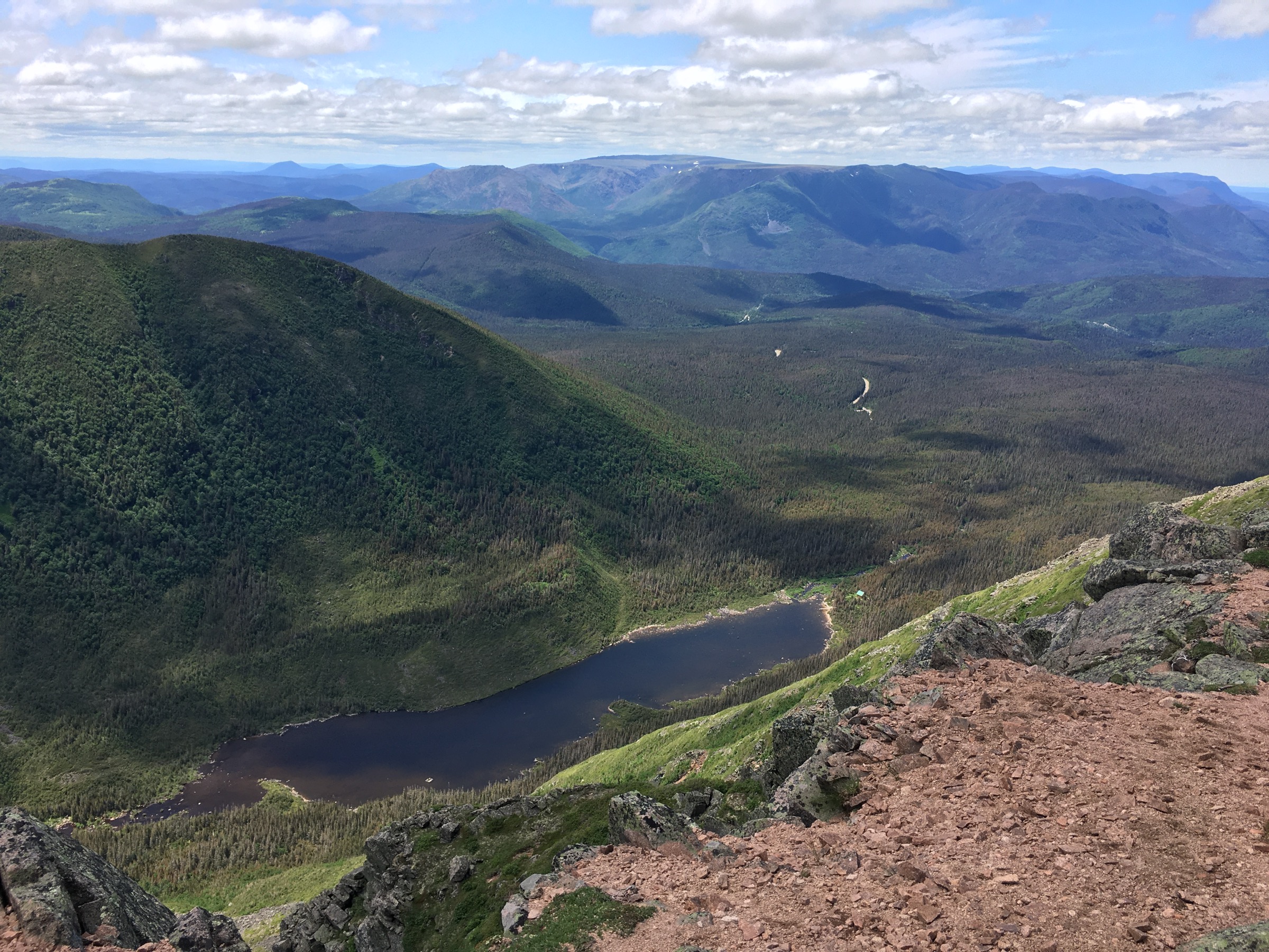
The route leaves the Discovery and Visitors Centre, climbs the northern slope of Mont Albert, reaches the broad summit plateau, then descends by the Cuve du Diable side to complete a long mountain circuit. The terrain changes from forest to exposed alpine plateau and steep rocky descent.
Why it is essential
Mont Albert is the signature Chic-Choc plateau hike, combining a major summit, alpine vegetation, long views, and the Cuve du Diable descent in a demanding but non-technical day.
Equipment
- Mountain hiking equipment: sturdy boots, waterproof and warm layers, food, water, map/GPS, navigation backup, headtorch, and trekking poles.
- Hat and gloves outside settled midsummer weather.
- Microspikes may be useful if snow remains early in the season.
Hazards and notes
- The plateau is highly exposed to wind, fog, and cold.
- Navigation can become difficult in poor visibility.
- Stay on marked trails to protect alpine vegetation.
- Early-season snow or autumn icing can materially change the difficulty.
GPX / KML links
| Source | URL | Format / access | Reuse status |
|---|---|---|---|
| Sépaq: Parc national de la Gaspésie trail table | sepaq.com | Official trail table / source route | Website terms not fully checked; no GPX found |
External links
2. Le Mont-Jacques-Cartier

Snapshot
Itinerary
The trail climbs from the Mont-Jacques-Cartier access point through subalpine forest and open tundra to the summit shelter and high point. The return follows the same route, within the controlled access window for the summit sector.
Why it is essential
Mont Jacques-Cartier is the highest and most emblematic accessible summit in the Chic-Chocs, with tundra habitat and broad views over the Gaspésie highlands.
Equipment
- Mountain hiking equipment, including sturdy boots, warm and waterproof layers, navigation backup, food, water, and sun / wind protection.
- Carry extra insulation even in summer.
Hazards and notes
- The route is exposed to severe wind, cold, and fog.
- Access is controlled, and the Sépaq visitor guide notes a daily access window of 10:00 to 16:00 for Mont Jacques-Cartier.
- Remain on the marked route to protect sensitive alpine habitat.
GPX / KML links
| Source | URL | Format / access | Reuse status |
|---|---|---|---|
| Sépaq: Parc national de la Gaspésie trail table | sepaq.com | Official trail table / source route | Website terms not fully checked; no GPX found |
| Sépaq: Parc national de la Gaspésie visitor guide (PDF) | sepaq.com | Official access / map context | Website / PDF terms not fully checked; GPX not found |
External links
- Sépaq — Parc national de la Gaspésie trail table
- Sépaq — Parc national de la Gaspésie visitor guide (PDF)
3. Le Mont-Xalibu via Lac aux Américains

Snapshot
Itinerary
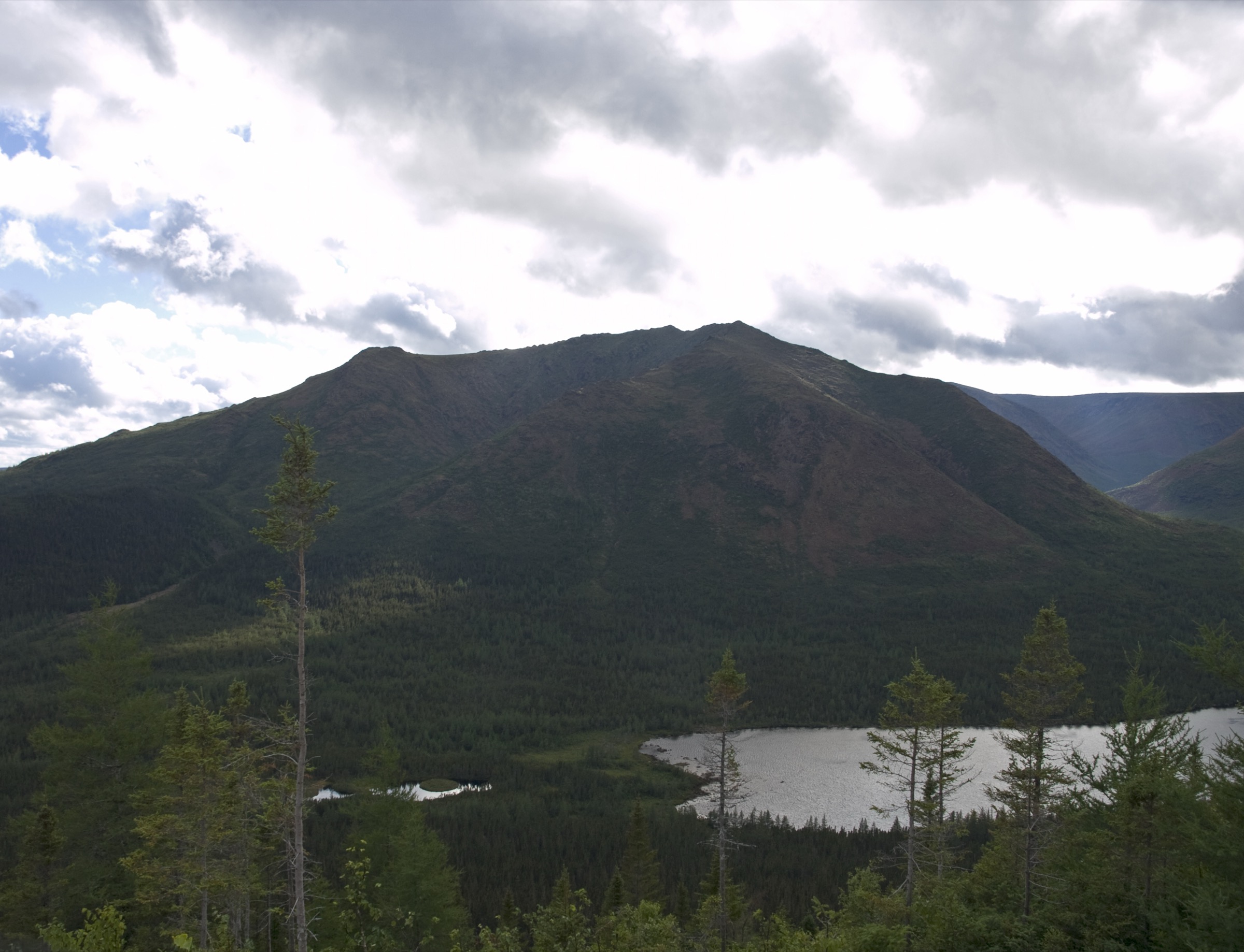
The route begins at Lac aux Américains, reaches the cirque lake, then continues above the basin toward Mont Xalibu. The upper trail enters rougher, more open terrain before returning by the same line.
Why it is essential
This route combines one of the park’s classic glacial lake basins with a higher McGerrigle summit approach, making it the key lake-and-tundra day hike in the region.
Equipment
- Mountain hiking equipment: boots, poles recommended, warm and waterproof layers, water, food, navigation backup, and sun / wind protection.
Hazards and notes
- The upper section is weather-exposed and can be slippery or snow affected early in the season.
- Stay on the marked path around Lac aux Américains and the alpine zone.
GPX / KML links
| Source | URL | Format / access | Reuse status |
|---|---|---|---|
| Sépaq: Parc national de la Gaspésie trail table | sepaq.com | Official trail table / source route | Website terms not fully checked; no GPX found |
External links
4. Le Mont-Olivine
Snapshot
Itinerary
The trail climbs from the Discovery and Visitors Centre through forest to an increasingly open ridge line with views toward Mont Albert, Lac du Diable, and the surrounding Chic-Choc terrain. The return follows the same trail.
Why it is essential
Mont Olivine gives a strong ridge-and-viewpoint alternative to the more crowded Mont Albert and Jacques-Cartier routes, with excellent sightlines into the central Chic-Chocs.
Equipment
- Mountain hiking equipment, including boots, waterproof and warm layers, water, food, map/GPS, and poles.
Hazards and notes
- The ridge can be windy and exposed, and the trail may be muddy or slippery after rain.
- Maximum elevation remains unresolved from official sources and should be verified from mapping or a new GPX.
GPX / KML links
| Source | URL | Format / access | Reuse status |
|---|---|---|---|
| Sépaq: Parc national de la Gaspésie trail table | sepaq.com | Official trail table / source route | Website terms not fully checked; no GPX found |
External links
5. Le Pic-de-l’Aube
Snapshot
Itinerary
The route follows marked park trail from the Pic-de-l’Aube trailhead through forest and higher crest terrain to the summit viewpoint, then returns by the same route.
Why it is essential
Pic-de-l’Aube adds western Chic-Choc representation to the selection and gives a less central but still substantial summit-view day hike within the maintained park network.
Equipment
- Mountain hiking equipment: sturdy footwear, weatherproof and warm layers, water, food, map/GPS, and navigation backup.
Hazards and notes
- Exposure, wet trail conditions, and limited rescue access should be expected.
- Maximum elevation and open-licence media still need follow-up verification.
GPX / KML links
| Source | URL | Format / access | Reuse status |
|---|---|---|---|
| Sépaq: Parc national de la Gaspésie trail table | sepaq.com | Official trail table / source route | Website terms not fully checked; no GPX found |
External links
Missing data / follow-up work
- No official downloadable GPX / KML files were found in this pass for the five routes.
- Elevation loss is not separately published by the official source; loop / out-and-back loss values are inferred as approximately equal to gain.
- Maximum elevations for Mont Olivine and Pic-de-l’Aube remain unresolved from official sources.
- Pic-de-l’Aube still needs a verified licence-compatible image.
- Shuttle schedules, opening dates, and trail restrictions should be rechecked before publication.