Regional overview
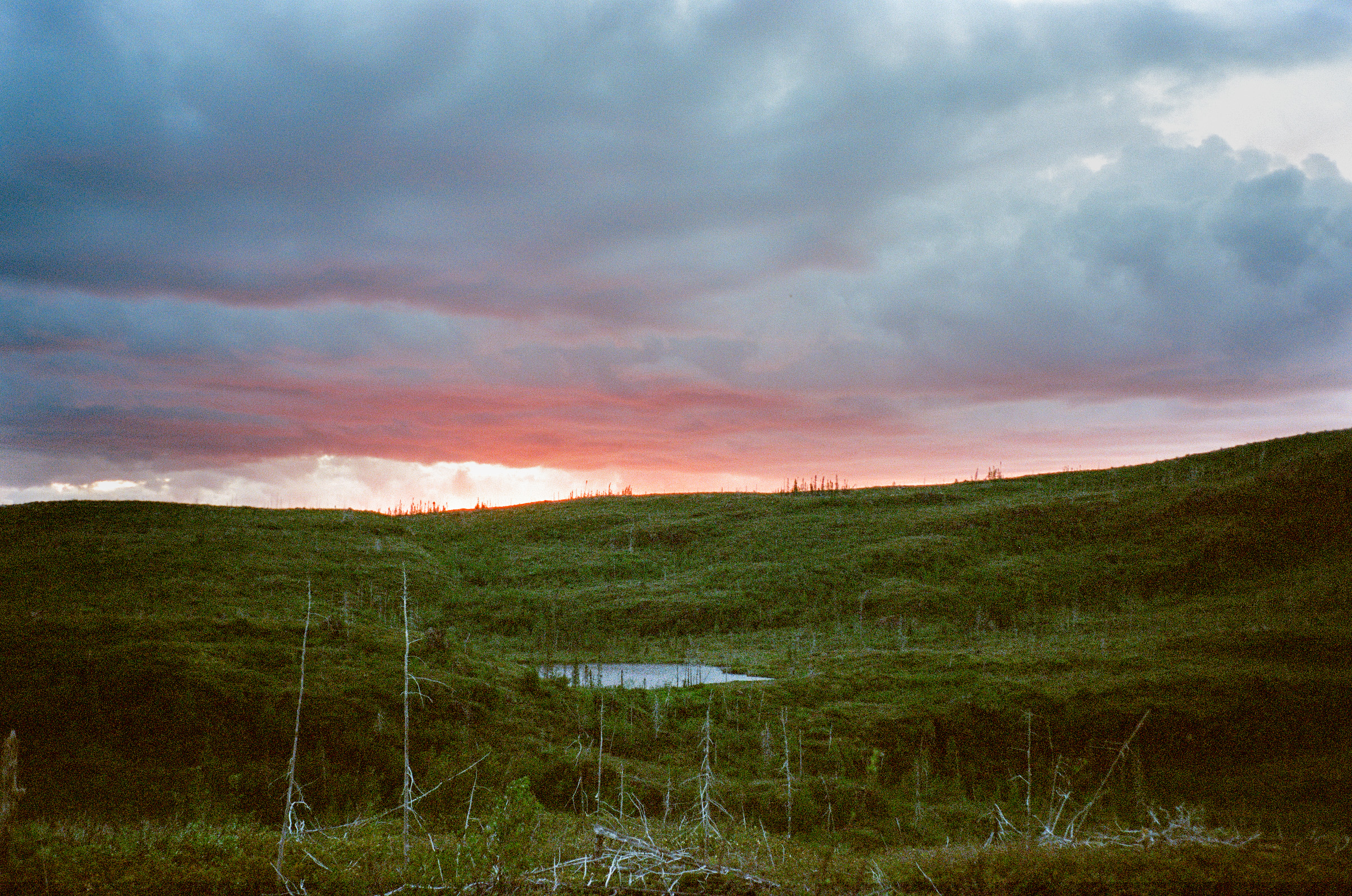
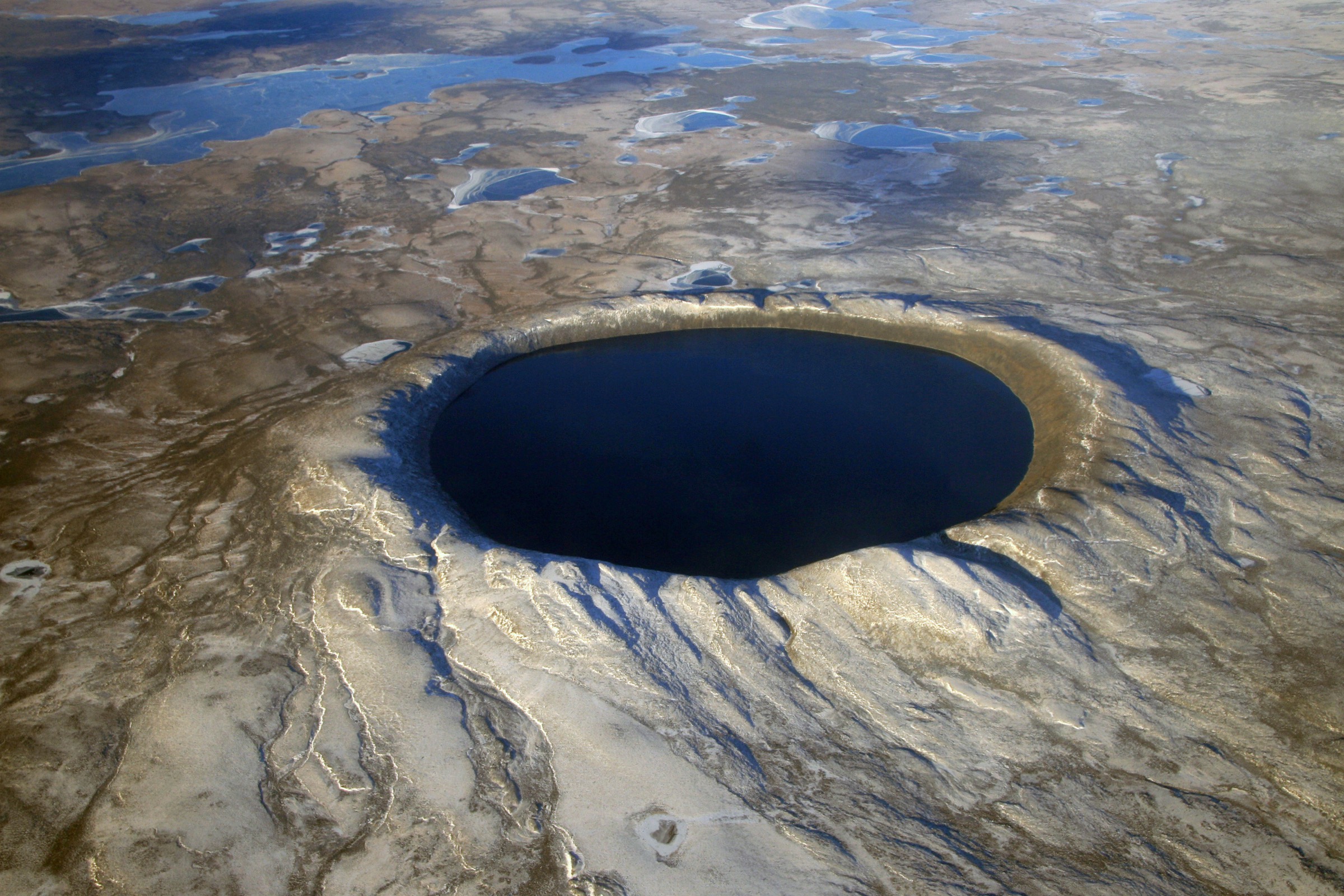
The Ungava Peninsula is the northern tip of Québec — the bulk of the Inuit homeland of Nunavik — and geologically a low northern extension of the Canadian Shield: an open, glacier-scoured plateau of ancient Precambrian rock, rolling at 300–600 m above sea level but cut by abrupt fault-controlled cuestas, river canyons, and coastal cliffs that make the relief feel mountainous. The highest published point in the day-hike catchment is the rim of the Pingualuit impact crater at 657 m above sea level. Tree-line lies hundreds of kilometres to the south; almost every walk described here is on exposed Arctic tundra of lichen, dwarf birch and granitic blockfield.
Two Nunavik parks anchor the walking on the peninsula: Parc national des Pingualuit, administered out of the Inuit village of Kangiqsujuaq on Hudson Strait, and the much larger Parc national Tursujuq, administered out of Umiujaq on Hudson Bay. Both parks are run jointly by the Kativik Regional Government and the Administration régionale Kativik and are commercially operated by Nunavik Parks (nunavikparks.ca). Trails are universally undeveloped — marked at best by cairns — and almost every visitor experience is sold as a guided package including charter flight, base-camp lodging at Manarsulik (Pingualuit) or the Tasiujaq camp (Tursujuq), and the services of Inuit guides. A fifth Nunavik park, Iluiliq National Park Reserve, is in creation around Cap Wolstenholme and Ivujivik; until it is gazetted, visits there are essentially ship-based or community-arranged.
The season is brutally compressed. The growing season around the Pingualuit crater is roughly 60 days, mid-June to mid-August. Snow normally lingers on north-facing slopes into July, and the first hard frosts can return in late August. Wind is the single most important objective hazard: there is no shelter on the plateau and a clear morning can become a horizontal sleet storm by mid-afternoon. Hudson Bay coast routes (Tursujuq, Nastapoka, Cap Wolstenholme) require active polar-bear awareness — the southern Hudson Bay subpopulation occupies all of this coastline and Inuit guides routinely carry firearms under their Nunavik Inuit Land Claim Agreement rights. Independent off-trail travel is, in practice, not permitted by either park; the meaningful day-hikes are those undertaken as part of a guided programme, and even hikers staying at the official camps are expected to register their walks and accept guide accompaniment for the longer routes.
Access is exclusively by air. Air Inuit operates scheduled flights from Montréal (YUL) through Kuujjuaq (YVP) or La Grande Rivière (YGL) to the regional hubs of Kangiqsujuaq (YWB), Umiujaq (YUD) and Ivujivik (YIK). Onward charters into the parks are by Twin Otter (Pingualuit) or motorboat (Tursujuq). The route distances below describe what fit walkers can complete in a single day from the relevant base camp; multi-day backcountry traverses exist in both parks but are excluded by the day-hike scope.
Selection rationale
The five routes have been chosen to represent the four geological signatures of the Ungava uplands — meteorite-impact crater, Hudsonian cuesta, Arctic river canyon and Hudson Strait sea-cliff — plus one cultural route that traces Inuit and Paleo-Inuit occupation around Le Goulet of Lac Guillaume-Delisle. The Pingualuit Crater Rim is included as the only true summit walk in the region and as the iconic image of Nunavik; the rim-and-descent half-day is the standard Pingualuit programme. Mont d’Youville and the Richmond Gulf cuesta walks are the standard day options offered from the Tasiujaq base camp at Tursujuq. Nastapoka Falls is the most-reproduced single day-walk in Tursujuq’s commercial programme. Le Goulet is included as the principal cultural day-walk in the Tursujuq sector.
Verification across the five entries is dominated by “Partially verified” (the two Pingualuit walks) and “Candidate only” (the Tursujuq walks): Nunavik Parks publishes route distances in marketing materials but not in public GPX downloads, and licence-compatible photography is concentrated almost entirely on the Pingualuit crater itself.
Summary table
| # | Hike | Country | Route type | Distance | Gain | Max elevation | Difficulty |
|---|---|---|---|---|---|---|---|
| 1 | Pingualuit Crater Rim circumnavigation | Canada | Loop | 18-22 km | ~250 m | 657 m | Strenuous |
| 2 | Pingualuit Crater Lake descent | Canada | Out-and-back | ~7 km | ~160 m | 600 m | Moderate (steep scramble) |
| 3 | Mont d’Youville / Richmond Gulf cuesta | Canada | Out-and-back | ~8 km | ~300 m | ~305 m | Moderate |
| 4 | Nastapoka Falls upper-rim walk | Canada | Out-and-back | ~10 km | ~80 m | ~80 m | Easy-moderate |
| 5 | Le Goulet cultural and archaeological walk | Canada | Out-and-back | 6-10 km | <100 m | ~150 m | Easy (exposed) |
1. Pingualuit Crater Rim circumnavigation
Snapshot
Itinerary
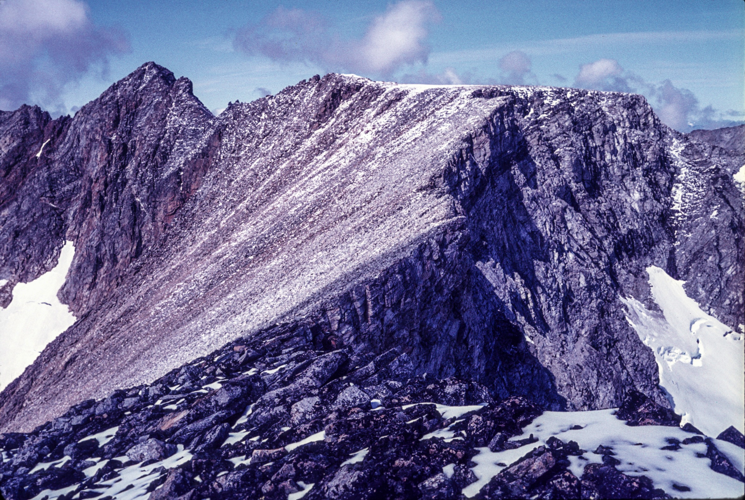
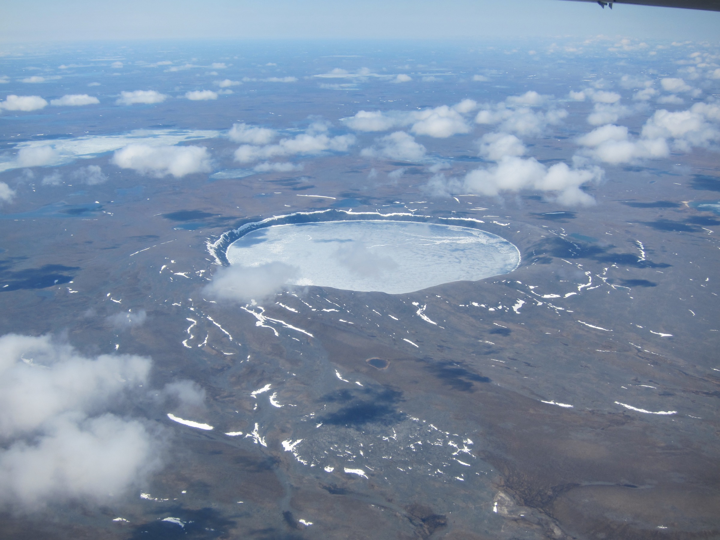
From the Manarsulik base camp on the shore of Lake Manarsulik the route follows an undeveloped path uphill across open tundra for about 2.5 km, gaining around 100 m to reach the south-west sector of the crater rim — the standard viewpoint. The rim itself is a near-circular ridge of impact-melted granitoid roughly 3.44 km in diameter; circumnavigation keeps the rim crest on the right and drops into and climbs out of several radial gullies. Footing is granite blockfield throughout with frequent loose slabs. The highest sector of the rim, on the north-eastern arc, lies at 657 m and gives the most complete view of the Pingualuk crater lake 267 m below — one of the deepest in North America and notable for its near-distilled-water clarity. Closing the loop, the path returns by the same access leg to camp. There is no water available on the rim itself.
Why it is essential
The Pingualuit crater is the single most iconic landscape feature of the Ungava Peninsula and one of the most-photographed-from-orbit lakes on Earth. The rim walk is the only day-hike in Nunavik that combines a recognisably summit experience with a globally significant geological feature, and it is the signature route of Parc national des Pingualuit.
Equipment
- Sturdy boots and trekking poles for the blockfield
- Windproof shell, full waterproofs, warm layer
- Hat and gloves even in midsummer
- Map and GPS with downloaded basemap; off-trail navigation by landmark and cairn
- Headtorch for early- or late-season days
- Nunavik Parks reservation — guide assignment is normal practice
- Bear-aware food storage at camp (black bear range; not polar bear country at the crater itself)
Hazards and notes
- Plateau at 61° N with no shelter; cold rain, fog and high wind can arrive within an hour
- Trekking poles strongly recommended for the blockfield
- The crater-lake descent (see Hike 2) is treated as a separate route
- Caribou of the Rivière aux Feuilles herd may be present May-July
- Dogs not permitted in Nunavik Parks back-country; independent unguided travel discouraged
GPX / KML links
No public route file. Nunavik Parks states that GPS files are available “through the Pingualuit park office” on request (819-338-3282). Crater centre approximately 61.2775°N, 73.6600°W.
External links
- Nunavik Parks — Parc national des Pingualuit
- Wikipedia — Pingualuit crater
- NASA Earth Observatory — Pingualuit Crater
2. Pingualuit Crater Lake descent
Snapshot
Itinerary
The first 2.5 km share the line of the rim circumnavigation, climbing across tundra from Manarsulik camp to the south-west sector of the crater rim. From the rim viewpoint the route drops directly into the crater on a guide-marked descent line through granite blockfield, losing roughly 160 m vertical at a sustained 40-45° angle, to reach the rocky north shore of Pingualuk Lake. The lake is among the clearest natural water in the world, with no inflow or outflow; visitors take a long break on the shore, and may be permitted, with a guide, a brief swim. Return is by the same line, reversing the scramble back up to the rim and descending the gentle tundra leg to camp.
Why it is essential
This is the only walk in Nunavik that ends at the inside of an impact-crater lake, and the only Pingualuit option that can be completed in half a day. Crater Explorer and Nunavik Parks describe the rim-and-descent combination as the standard short-stay outing at Pingualuit; it is the route used in the two-night Weekend in parc national des Pingualuit package.
Equipment
- Mountain hiking equipment with sticky-soled boots
- Trekking poles essential for the descent
- Helmet recommended on the descent line — loose blocks and rockfall on the 40-45° slope
- Nunavik Parks reservation and guide assignment (standard practice)
Hazards and notes
- The scramble to the lake is the single most dangerous standard manoeuvre in Pingualuit park literature: a 40-45° slope of unstable granite blocks with no fixed protection
- Park guides will refuse the descent in wet conditions
- No swimming without explicit guide authorisation; Pingualuk Lake water stays near 0 °C below a thin surface skin even in midsummer
GPX / KML links
No public route file; see Hike 1 for park-office contact. Descent line waypoint approximately 61.275°N, 73.665°W.
External links
3. Mont d’Youville / Richmond Gulf cuesta viewpoint
Snapshot
Itinerary
From the Tasiujaq base camp the standard cuesta walk climbs west-south-west across open tundra and dwarf birch, gaining elevation on a low-angle dip slope. As the gradient steepens, the walker reaches the cuesta crest with its escarpment dropping sharply on the seaward side; from the rim the view sweeps over Lac Guillaume-Delisle (Lac Tasiujaq / Richmond Gulf) inland, and over Hudson Bay and the Nastapoka Islands to the west. Nunavik Parks describes the Hudsonian cuestas of Tursujuq as “Quebec’s most extensive system of cuestas” and “the highest of the province.” Return is by the same line. No water on the cuesta itself; carry sufficient supplies from camp.
Why it is essential
The cuestas are the defining geological feature of Tursujuq and the reason the park was created; a representative cuesta ascent is the standard hiking activity offered by park staff from the base camp. The named summit “Monts D’Youville” is the highest mapped point in the immediate vicinity of the Tursujuq base-camp circuit.
Equipment
- Standard hiking equipment with sturdy boots
- Warm layer and windproof shell (cuesta crest is fully exposed to onshore Hudson Bay weather)
- Polar-bear deterrents — region is part of the Southern Hudson Bay polar bear subpopulation range
- Nunavik Parks reservation and guide accompaniment (standard at Tursujuq)
Hazards and notes
- Polar bear awareness mandatory anywhere the route descends towards the coast or the Tasiujaq shoreline
- Inuit guides normally carry a firearm under Nunavik Inuit Land Claim Agreement provisions
- Cuesta escarpments are steep on the coastal side — walking the rim itself requires care in wind
- Published statistics are imprecise; figures above are interpolated from generic park descriptions and the PeakVisor elevation for Monts D’Youville
GPX / KML links
No public route file. Park office: 819-331-5454. Monts D’Youville waypoint approximately 56.6°N, 76.5°W (PeakVisor — confirm before use).
External links
4. Nastapoka Falls upper-rim walk
Snapshot
Itinerary
A motorboat transfer of roughly one hour runs north from Umiujaq along the Hudson Bay coast to the mouth of the Nastapoka River, where there is an extensive sandy beach. From the beach the route climbs the south bank of the river and follows the rim of the lower canyon upstream for about 5 km to a viewpoint immediately above Nastapoka Falls, which plunge 35 m directly into Hudson Bay. The upper plateau gives a wide view over the Nastapoka Islands offshore (themselves cuestas) and over the lower river valley. Return is by the same line back to the beach for boat pick-up.
Why it is essential
Nastapoka Falls is the most-reproduced single image of Tursujuq National Park and is described in Nunavik Parks literature as the central artery of the park’s southern sector. The upper-rim walk is the standard summer day-trip sold from Umiujaq and is the only Nunavik day-hike that combines a Hudson Bay coastal beach with a true waterfall viewpoint.
Equipment
- Waterproof boots (beach landing and wet tundra)
- Windproof / waterproof shell — Hudson Bay coast is consistently cold and wet
- Polar-bear deterrents — active range of the Southern Hudson Bay polar bear subpopulation
- Inuit guide accompaniment — Nunavik Parks treats this route as guided-only
Hazards and notes
- Polar bears present along the entire route in summer
- Boat transfer is sensitive to Hudson Bay sea state and can be cancelled at short notice
- Footing near the falls rim is exposed and slippery in spray
- Independent unguided access is not feasible from Umiujaq
GPX / KML links
No public route file. Park office: 819-331-5454. Nastapoka Falls waypoint approximately 56.92°N, 76.83°W.
External links
- Nunavik Parks — Parc national Tursujuq
- Wikipedia — Nastapoka River
- Nunavik Parks — Polar bear best-practice guide (PDF)
5. Le Goulet cultural and archaeological walk
Snapshot
Itinerary
From the Tasiujaq base camp a motorboat carries walkers across to Le Goulet (“the bottleneck”), the 5 km glacier-polished passage where Lac Guillaume-Delisle drains into Hudson Bay between cliffs reaching up to 200 m. Park guides lead a walk along the cliff-top above the passage, stopping at a sequence of Paleo-Inuit, Dorset and Thule archaeological sites identified during the 2004-2010 Avataq Cultural Institute surveys; more than 70 sites have been documented around Lac Guillaume-Delisle. Reconstructed or in-situ qammaq (semi-subterranean stone-and-sod winter dwellings) and tent rings are typically included in the interpretive walk. The Goulet is also the entry point to one of the largest beluga sanctuaries on Hudson Bay. Return is by the same line to the boat.
Why it is essential
The cultural and archaeological heritage of the Lac Guillaume-Delisle region is the single most-emphasised non-geological reason for Tursujuq National Park’s creation, and the Goulet is the historical Inuit-Cree meeting and trading place. A short interpretive walk along the passage with Inuit guides is included in every Nunavik Parks summer expedition to Tursujuq.
Equipment
- Standard hiking equipment with sturdy boots
- Windproof shell — passage is wind-funnelled
- Polar-bear deterrents and Inuit guide accompaniment (mandatory in practice)
- Nunavik Parks reservation
Hazards and notes
- Passage walls are vertical to overhanging in places; the cliff-top line is exposed
- Archaeological sites are protected: do not move stones, pick up artefacts, or step on tent rings
- Polar bears present year-round along the Hudson Bay coast
- Cree and Inuit families continue to use the area for traditional activities; the guided programme builds in cultural protocols
GPX / KML links
No public route file. Park office: 819-331-5454. Goulet centre approximately 56.27°N, 76.83°W.
External links
- Nunavik Parks — Parc national Tursujuq
- Avataq Cultural Institute
- Wikipedia (fr) — Lac Guillaume-Delisle
External links
- Nunavik Parks — main site
- Nunavik Parks — Parc national des Pingualuit
- Nunavik Parks — Parc national Tursujuq
- Nunavik Parks — Polar bear best-practice guide (PDF)
- Wikipedia — Pingualuit National Park
- Wikipedia — Pingualuit crater
- Wikipedia — Tursujuq National Park
- Crater Explorer — Pingualuit Impact Crater
- NASA Earth Observatory — Pingualuit Crater
- Avataq Cultural Institute