Regional overview
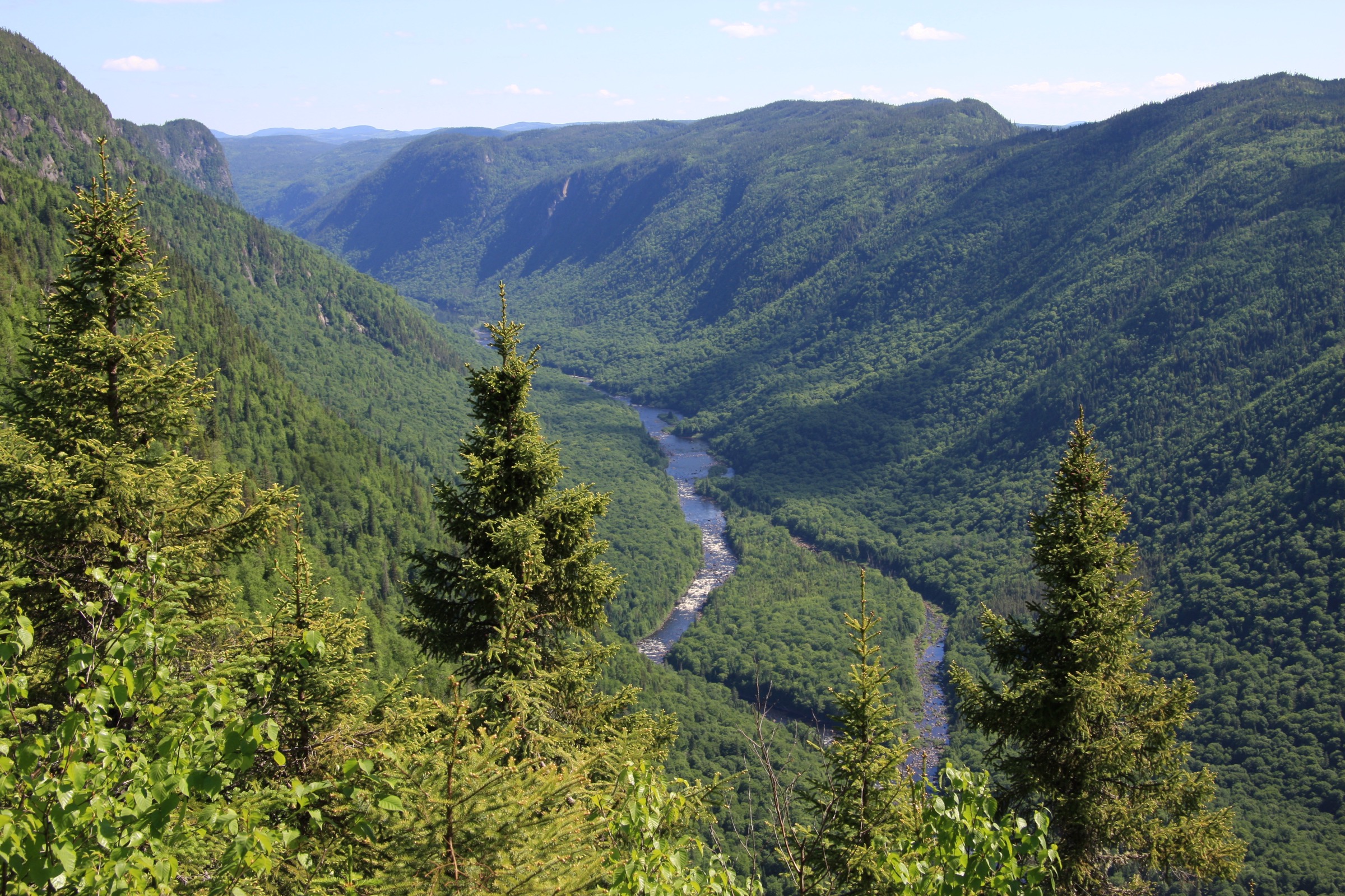
The Jacques-Cartier Highlands sit on the southern edge of the Laurentian Mountains, a deeply dissected sub-range of the Canadian Shield rising directly north of Québec City. The signature landscape is the Jacques-Cartier valley itself: a broad, U-shaped trough cut into Precambrian gneiss and granite, with valley walls climbing roughly 550 m from a river floor at about 170 m to plateau rims near 750 m. The plateau on either side carries boreal-mixed forest of sugar maple, yellow birch, balsam fir and black spruce, dotted with small kettle lakes, peatlands and beaver ponds. The valley floor is a corridor of mature mixedwood broken by the Jacques-Cartier and Sautauriski rivers, both classic Canadian Shield watercourses with long flatwater pools and rocky rapids.
Hiking access concentrates in three protected areas. Parc national de la Jacques-Cartier, managed by the Société des établissements de plein air du Québec (Sépaq), covers roughly 670 km² of the central valley and carries the densest network of waymarked summer trails (Les Loups, Le Scotora, L’Éperon, La Tourbière, La Croisée, Les Coulées and others). The much larger Réserve faunique des Laurentides sits immediately to the north and offers backcountry hiking around Camp Mercier and Lac à l’Épaule. South of the park boundary, the Vallée Bras-du-Nord — a coopérative de solidarité based in Saint-Raymond on the Bras-du-Nord tributary — manages around 80 km of summer trails to waterfalls, granite cliffs and ridge belvédères. Closer to the city, the small but botanically significant Parc de la forêt ancienne du mont Wright in Stoneham-et-Tewkesbury protects an old-growth yellow-birch and sugar-maple stand on the southern flank of the highlands.
The reliable hiking season runs from roughly mid-May (lower trails, mud permitting) through mid-October, with peak fall colour in late September. Higher viewpoints such as Les Loups and Le Scotora can hold snow and ice into early May and again from late October. Black flies and mosquitoes are intense from late May through mid-July. The area is black bear (not grizzly) habitat; bear-aware food storage is sensible but bear spray is rarely carried. The most distinctive practical issue is access: Parc national de la Jacques-Cartier requires a Sépaq daily access pass that frequently sells out for weekends and holidays in summer and during fall colour, and pre-booking up to 30 days in advance is strongly recommended. Several Vallée Bras-du-Nord trails also require an access fee at the Shannahan or Saint-Raymond reception. Cell coverage is patchy in the valley bottoms and absent on many summit ridges.
Selection rationale
The five hikes span the highlands’ main hiking centres and represent its dominant landscape signatures: a high valley-rim viewpoint hike that is the de facto signature route of the region (Les Loups); a longer, historical valley-rim ridge to a true Laurentian summit (Le Scotora to Mont Andante); an easier panoramic loop on the lower valley with multiple cliff-edge overlooks (L’Éperon on Montagne de l’Épaule); the iconic waterfall and suspension-bridge hike of the Vallée Bras-du-Nord (Sentier Bras-du-Nord to Chute Delaney, with optional Belvédère extension); and an accessible, year-round old-growth-forest summit on the southern edge of the highlands (Mont Wright). Together they cover summit, ridge, cliff-edge, valley and old-growth themes from three different protected areas, without duplicating any one objective. The Sentier du Philosore — the Vallée Bras-du-Nord’s flagship long route — was considered but excluded as a 30 km, multi-day point-to-point trek requiring overnight refuge stays rather than a one-day outing. Mont Jacques-Cartier in the Chic-Chocs of Gaspésie is sometimes confused with this region and is also excluded.
Summary
| # | Hike | Country | Route type | Distance | Gain | Max elevation | Difficulty |
|---|---|---|---|---|---|---|---|
| 1 | Sentier Les Loups | Canada | Out-and-back | ~10.6 km | ~755 m | ~700 m | Strenuous |
| 2 | Le Scotora (to Mont Andante) | Canada | Out-and-back | ~15.8–16 km | ~540–708 m | ~809 m | Strenuous |
| 3 | L’Éperon (Montagne de l’Épaule loop) | Canada | Loop | ~5.4 km | ~220 m | ~460 m | Moderate |
| 4 | Sentier Bras-du-Nord to Chute Delaney | Canada | Out-and-back | ~8–13 km | ~120–320 m | ~420 m | Moderate |
| 5 | Mont Wright (Sentier du Sommet loop) | Canada | Loop | ~5.5 km | ~280 m | 483 m | Moderate |
1. Sentier Les Loups
Snapshot
Itinerary
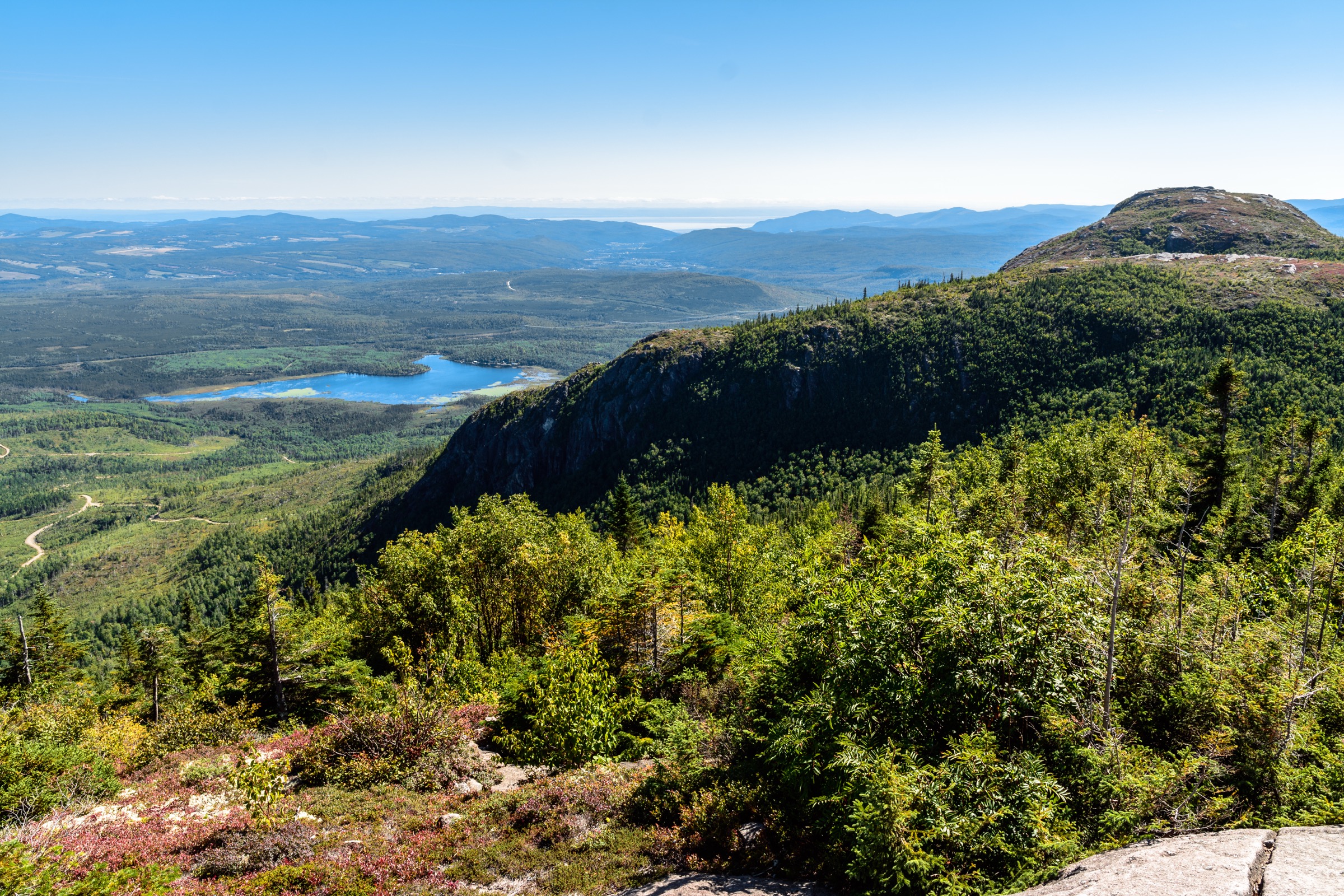
The trail begins on the west side of the valley at the Les Loups parking area on Chemin du Parc-National, opposite the Sautauriski confluence. It crosses the Jacques-Cartier River on a footbridge and immediately starts climbing the steep eastern valley wall through mature mixed forest. The grade is sustained for the first 2 km, gaining roughly 400 m via switchbacks on rocky single-track, before easing onto a forested shoulder. After a brief flatter section the trail steepens again to gain the broad summit area of Mont Sautauriski (sometimes signed as Pic Sautauriski) at approximately 700 m. A series of open belvédères — three principal viewpoints, of which Les Loups itself is the highest and most exposed — line the rim, with unobstructed views down the U-shaped valley to the south, across the Sautauriski drainage to the east, and toward the inner-park plateaus to the north. The descent retraces the ascent. The maintained summer trail is signed and well-trodden; the winter routing differs slightly and requires microspikes or crampons.
Why it is essential
Sentier Les Loups is the single most frequented hiking trail in Parc national de la Jacques-Cartier and the route most commonly used to introduce visitors to the deep valley landscape that defines the region. Its summit belvédères give the cleanest, most photographed view of the U-shaped glacial trough, and the trail is included in essentially every regional and provincial guidebook listing the essential Laurentian hikes near Québec City.
Equipment
- Sturdy hiking boots or supportive trail runners
- Trekking poles useful on the steep descent
- Weatherproof shell and warm mid-layer (summit exposed to wind)
- Sun protection
- 2 L water; no reliable on-route source after the river crossing
- Map and GPS download
- Insect repellent from late May through July
- Microspikes from late October into May; mandatory in winter
Hazards and notes
- Sustained steep ascent and descent; the descent is hard on knees.
- Cliff-edge belvédères are unfenced; keep well clear of the rim in icy or wet conditions.
- Black bear habitat; standard food-storage practice recommended.
- Sépaq daily access pass required and frequently sells out for weekends, holidays and fall colour; pre-book up to 30 days ahead.
- Dogs are not permitted on Sentier Les Loups.
- Cell coverage is patchy along the trail and absent at the summit.
Routes and maps
| Source | URL |
|---|---|
| Sépaq — short hiking trails (Jacques-Cartier) | sepaq.com |
| Balise Québec — Sentier Les Loups fiche (PDF) | baliseqc.ca |
| OpenStreetMap — Sentier des Loups | openstreetmap.org |
| AllTrails — Sentier les Loups | alltrails.com |
External links
- Sépaq — Parc national de la Jacques-Cartier
- Sépaq — Jacques-Cartier Visitor Guide (PDF)
- Versant plein air — Les Loups
2. Le Scotora (to Mont Andante)
Snapshot
Itinerary
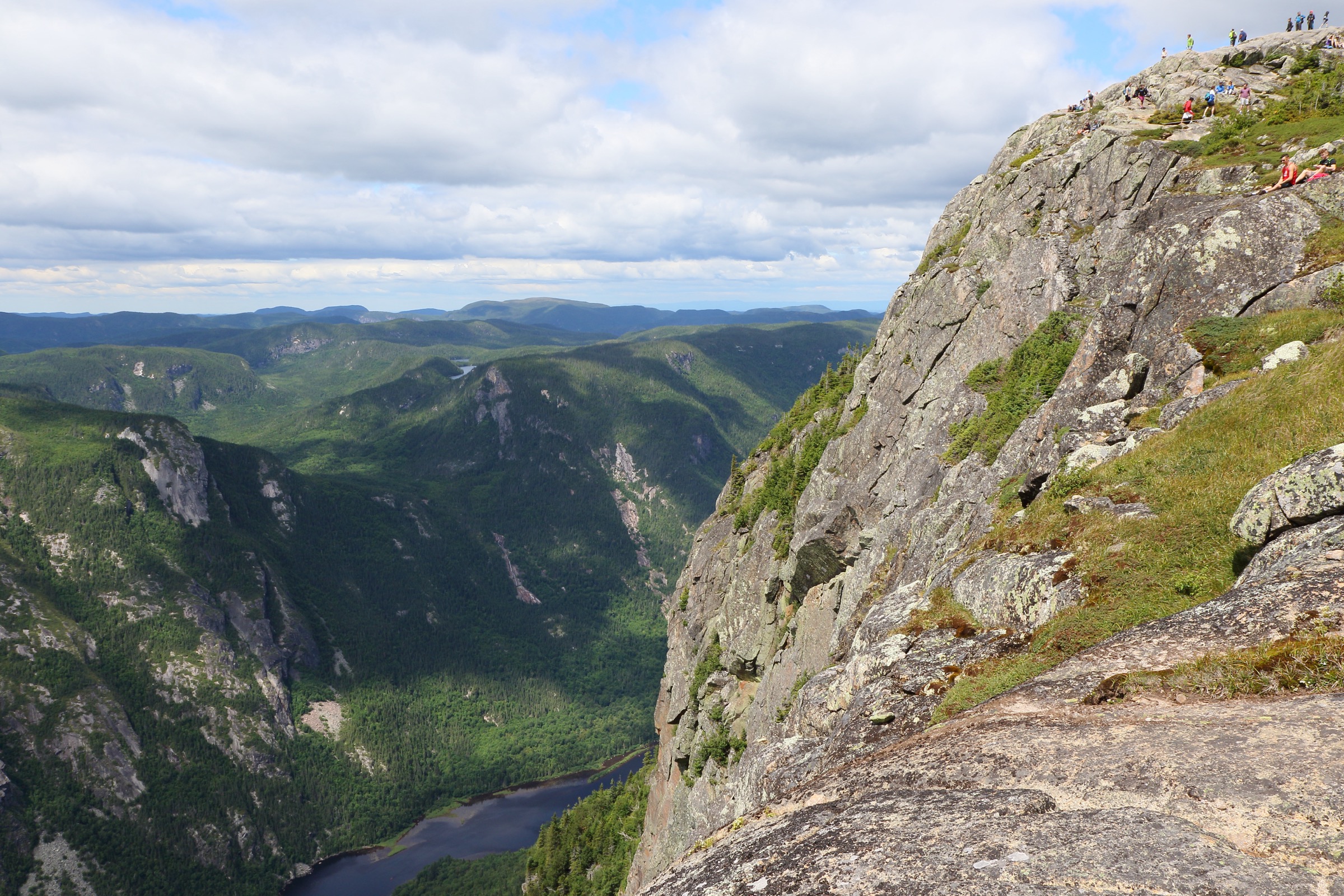
The trailhead sits near km 29 of the Chemin du Parc-National, deep in the upper Jacques-Cartier valley. The path starts gently on an old forest road along the lower flanks before becoming a foot trail and beginning a steady, sustained climb up the east-side valley wall. The grade is rarely sharp but is almost continuous, gaining elevation through closed mature forest with little exposure or view for most of the ascent. After approximately 7–8 km the trail tops out on the broad summit dome of Mont Andante at about 809 m — the highest objective on the park’s day-hike network. A short open belvédère gives a sweeping panorama over the Jacques-Cartier valley, the river roughly 600 m below, and the inner-park plateaus to the east and north. The descent retraces the ascent. The trail follows the line of a historic route used in earlier centuries by Innu travellers and, later, by Jesuit missionaries moving between the St Lawrence and the Saguenay watershed; interpretive material at the trailhead notes this heritage.
Why it is essential
Le Scotora is the longest and highest summer day-hike in Parc national de la Jacques-Cartier and the best route in the park for walkers seeking solitude and a true summit objective. It rewards a sustained climb with the broadest valley panorama available within the park, and it carries genuine cultural depth as a historic Indigenous and missionary route — qualities that distinguish it from the shorter, busier Les Loups hike.
Equipment
- Sturdy hiking boots
- Trekking poles recommended for the long sustained descent
- Weatherproof shell and warm mid-layer
- Sun protection
- 2.5–3 L water; no reliable on-route source above the lower forest road
- Map and GPS download; the route is signed but long
- Headtorch on shorter shoulder-season days
- Insect repellent late May through July
- Microspikes in early and late season
Hazards and notes
- Long, sustained ascent; turn-around time should be calculated before the summit.
- Limited views for most of the climb; the panorama is concentrated at the summit.
- Black bear habitat.
- Sépaq daily access pass required and may sell out for weekends; pre-book up to 30 days ahead.
- Dogs are not permitted on Le Scotora.
- Cell coverage absent on the summit and along most of the ascent.
Routes and maps
| Source | URL |
|---|---|
| Sépaq — short hiking trails (Jacques-Cartier) | sepaq.com |
| OpenStreetMap — Sentier Le Scotora | openstreetmap.org |
| AllTrails — Sentier Le Scotora | alltrails.com |
| Wikiloc — Le Scotora (Rando-Québec) | wikiloc.com |
External links
- Trekking-Québec — Le Scotora
- Gen-Hike — Stoneham-et-Tewkesbury, Mont Andante (Scotora)
- Dan en bottines — Sentier Scotora pour le Mont Andante
3. L’Éperon (Montagne de l’Épaule loop)
Snapshot
Itinerary
The trail leaves the parking area on the east side of the Chemin du Parc-National, crosses or skirts a small tributary, and begins climbing a moderately graded single-track up the lower west flank of Montagne de l’Épaule. The route is built as a loop, with the ascent on one arm and a slightly different return on the other. A series of three principal cliff-edge belvédères opens at intervals along the upper traverse, each one giving an overhead view of the Jacques-Cartier River as it meanders through its glacial trough. The middle belvédère, set squarely above one of the river’s tightest meanders, is the most photographed point on the route. The trail then loops back through mixed forest to the trailhead. Total elevation change is modest and the path is well graded, with rock steps and occasional handrails on the steeper sections near the rim.
Why it is essential
L’Éperon is the most accessible of the valley-rim viewpoint hikes in Parc national de la Jacques-Cartier, achievable in a half-day at moderate fitness, and the best short route for a first encounter with the U-shaped valley landscape. It is widely used as a warm-up before Les Loups or as a stand-alone family outing, and its belvédères are among the most photographed locations in the park.
Equipment
- Standard hiking shoes or light boots
- Weatherproof layer
- Water (1–1.5 L)
- Sun protection
- Insect repellent late May through July
- Optional trekking poles
Hazards and notes
- Cliff-edge belvédères are partially fenced but include sections without barriers; supervise children.
- Black bear habitat; food-storage practice recommended.
- Sépaq daily access pass required; the trail is busy on summer weekends and fall colour weekends.
- Dogs permitted on L’Éperon (one of five summer trails in the park where leashed dogs are allowed).
- Trail can be icy at the rim in shoulder season.
Routes and maps
| Source | URL |
|---|---|
| Sépaq — short hiking trails (Jacques-Cartier) | sepaq.com |
| OpenStreetMap — L’Éperon area | openstreetmap.org |
| AllTrails — Éperon Trail | alltrails.com |
| Gaia GPS — Montagne de l’Épaule via L’Éperon | gaiagps.com |
External links
- Spirit Bird Photography — L’Éperon trail guide
- Dan en bottines — Sentier de l’Éperon pour la Montagne de l’Épaule
- Wine, Wilderness and Wanderlust — L’Éperon Trail
4. Sentier Bras-du-Nord to Chute Delaney
Snapshot
Itinerary
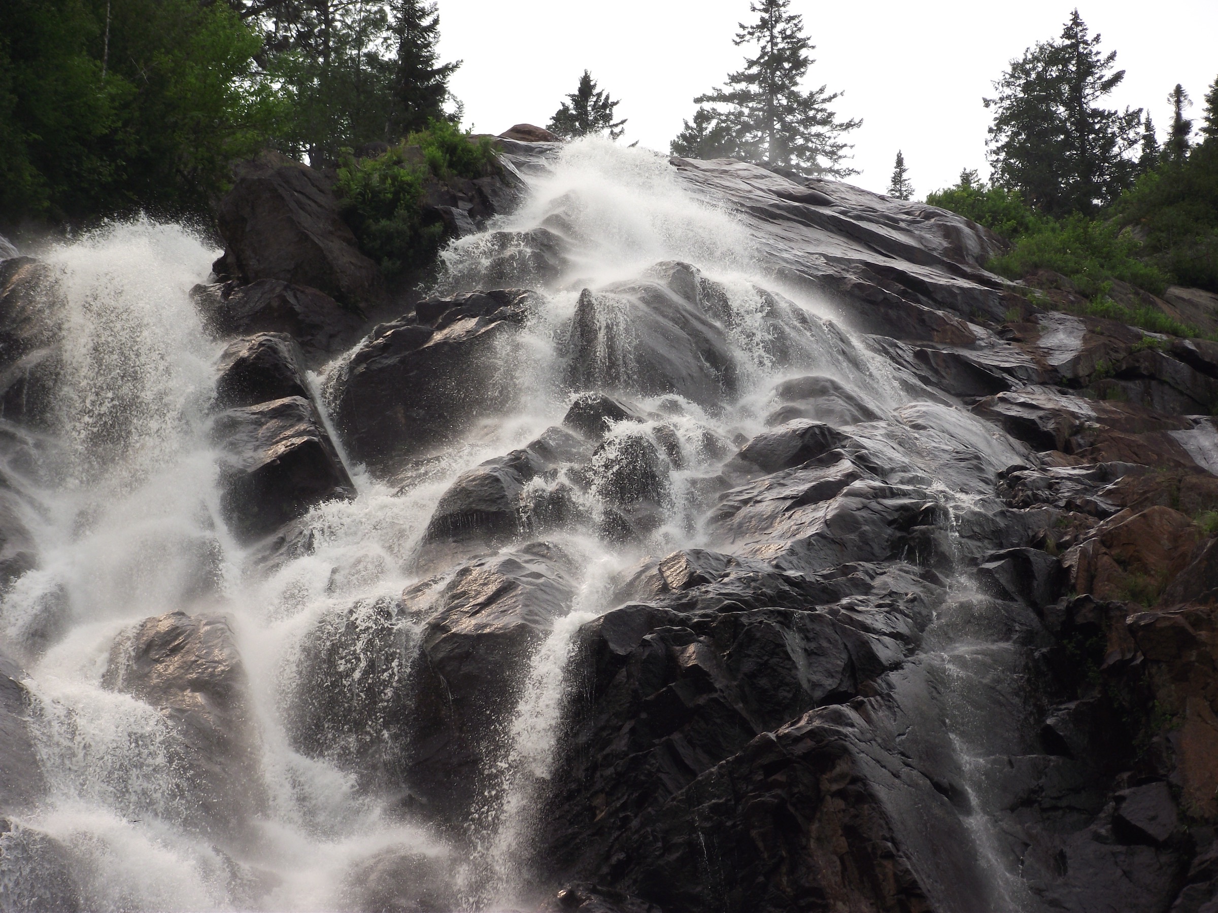
From the Shannahan reception the trail follows the south bank of the Bras-du-Nord upstream through mature riparian forest, crossing the river on a long suspension footbridge — one of the most photographed features in the network. The path then continues along the north bank on a well-graded single-track with several picnic areas and access points to the river, climbing gently for roughly 4 km to reach the base of Chute Delaney, a 150 m cataract sliding down a granite slab on a tributary cliff. The base of the falls is the natural turn-around for the shorter version of the hike. The full version adds a sustained climb of approximately 200 m up the headwall to a Belvédère perched at the lip of the falls, with a panoramic view down the Bras-du-Nord valley toward Mont Gibraltar and the surrounding Laurentian uplands. The descent retraces the ascent.
Why it is essential
The Bras-du-Nord trail to Chute Delaney is the signature day-hike of the Vallée Bras-du-Nord and the most representative route in the southern Jacques-Cartier Highlands. It combines the network’s iconic suspension bridge, a 150 m waterfall and — with the extension — a high cliff-edge belvédère over a deep tributary valley, landscape qualities that no Parc national de la Jacques-Cartier trail duplicates. It is also a flagship of the Vallée Bras-du-Nord coopérative de solidarité, a community-managed conservation and outdoor recreation project widely recognised in Quebec.
Equipment
- Hiking shoes or light boots
- Trekking poles useful on the Belvédère climb and descent
- Weatherproof layer
- Water (2 L) and food
- Sun protection
- Insect repellent late May through July
- Map and GPS download; the Vallée Bras-du-Nord trail network uses the Ondago app for digital maps
Hazards and notes
- The Belvédère above the falls is at the edge of a high cliff; railings and sign instructions must be respected.
- The Bras-du-Nord river can rise quickly after heavy rain; the suspension bridge handles this, but small tributary crossings on the trail may become slippery.
- Black bear habitat.
- A day-use access fee is charged at the Shannahan reception.
- Dog access varies by sector; check the current Vallée Bras-du-Nord rules.
- The trail is popular and parking at the Shannahan reception can fill on summer weekends; arrive early.
Routes and maps
| Source | URL |
|---|---|
| Vallée Bras-du-Nord — hiking trail map (PDF) | valleebrasdunord.com |
| Vallée Bras-du-Nord — interactive trail map | valleebrasdunord.com |
| OpenStreetMap — Sentier Bras-du-Nord (Shannahan) | openstreetmap.org |
| AllTrails — Bras-du-Nord Trail (Chute Delaney) | alltrails.com |
External links
- Vallée Bras-du-Nord — Sentier Bras-du-Nord
- Vallée Bras-du-Nord — hiking overview
- Onyva.quebec — Sentiers de la chute Delaney
5. Mont Wright (Sentier du Sommet loop)
Snapshot
Itinerary
From the main parking area on Chemin Saint-Edmond, the trail enters the protected old-growth stand on the Sentier de la Forêt Ancienne. Interpretive panels describe the yellow-birch and sugar-maple cohort, with several individual trees over 300 years old, and the distinctive “abris sous roches” — large granite blocks and overhangs left by glacial action that form natural shelters along the lower path. The trail climbs gradually through closed mature forest before steepening on the Sentier du Sommet to the upper part of the mountain. A short final climb reaches the summit at 483 m, where rain shelters and a viewpoint give a southern panorama over the Stoneham ski station, the Hibou and Hurons valleys and the front of the Laurentian range. The descent follows the Sentier Vaillant on the south side, completing the loop back to the parking area. Multiple variants are possible thanks to the 6.5 km network; the full perimeter loop is the most commonly recommended summer outing.
Why it is essential
Mont Wright protects one of the last accessible old-growth maple-birch stands in the Laurentian foothills and is recognised by the Quebec Ministry of Natural Resources as an exceptional forest ecosystem. The summit loop combines genuine botanical interest, geological features in the boulder shelters, and a representative Laurentian summit panorama — all within 30 km of central Québec City, making it the most accessible day-hike in the highlands for visitors without a full day in Parc national de la Jacques-Cartier. The park is also open year-round, including in shoulder seasons when Sépaq trails are closed for transition.
Equipment
- Hiking shoes or light boots
- Weatherproof layer
- Water (1.5 L)
- Sun protection
- Insect repellent late May through July
- Microspikes from late October to April
Hazards and notes
- Steep, root-laced sections on the upper Sentier du Sommet.
- Rock-climbing activity takes place on the cliffs; respect posted instructions and stay clear of climbing areas.
- A daily access fee is charged at the entrance (CAD 8 reported in 2024–2025).
- Leashed dogs are welcome on the park trails.
- Trail is open daily from sunrise to sunset.
Routes and maps
| Source | URL |
|---|---|
| Ville de Stoneham — Parc du Mont Wright | villestoneham.com |
| Plein air à la carte — Sentiers du Mont Wright | pleinairalacarte.com |
| OpenStreetMap — Mont Wright trail network | openstreetmap.org |
| AllTrails — Sommet du Mont Wright | alltrails.com |
External links
- Tourisme Jacques-Cartier — Mont Wright
- Parcs naturels Québec — Parc de la forêt ancienne du mont Wright
- Espaces — Mont Wright forêt ancienne à l’état pur