Regional overview
The Grands-Jardins and Hautes-Gorges parks form the mountainous core of the Charlevoix astrobleme, a 56 km diameter meteorite impact crater roughly 450 million years old that lifted and faulted the underlying anorthosite and Grenville basement into the highest summits of the southern Laurentian Mountains. Two adjacent SEPAQ parks protect this core: Parc national des Grands-Jardins (319 km², created 1981), a broad rolling plateau between Saint-Urbain and the Mont du Lac des Cygnes massif; and Parc national des Hautes-Gorges-de-la-Rivière-Malbaie (225 km², created 2000, Québec’s 20th provincial park), a glacially deepened gorge whose walls climb up to 800 m above the Malbaie River. Both parks sit within the UNESCO Charlevoix World Biosphere Reserve.
The hiking character is unusually varied for so compact an area. Grands-Jardins is the most northern-feeling landscape in southern Québec: a sub-arctic taiga of black spruce, lichen and dwarf shrub more typical of latitudes 500 km further north, with a small but symbolically important woodland caribou herd, broad views from rounded glaciated summits, and an arctic-alpine vegetation cap on the highest tops (Mont du Lac des Cygnes, 980 m). Hautes-Gorges is the opposite signature: a deep, narrow glacial valley with cliffs that rival anything east of the Rockies, sustained valley-floor walks along the Malbaie, and a single iconic summit climb (L’Acropole-des-Draveurs, on the flank of Montagne des Érables, 1,048 m — the highest peak in the park).
Access centres on Saint-Urbain (km 21 of Route 381, about 90 minutes from Quebec City) for Grands-Jardins, and on Saint-Aimé-des-Lacs (Route 138 to Rue Principale, about 30 km / 30 minutes to the Félix-Antoine-Savard visitor centre) for Hautes-Gorges. Grands-Jardins is open year-round and links into a winter snowshoe and backcountry-ski network. Hautes-Gorges operates roughly 20 April to 22 October; private cars are prohibited beyond the Félix-Antoine-Savard centre during the summer season, and a free continuous shuttle runs every fifteen minutes or so to the Le Draveur sector and the Acropole-des-Draveurs trailhead.
The typical snow-free season for upper trails is mid-May to mid-October in Grands-Jardins and late May to mid-October in Hautes-Gorges, with summits holding patches into early June. Both parks lie in black-bear range; there are no grizzlies. Weather on the exposed summits can deteriorate quickly, with cold rain or thunderstorms possible even in midsummer. The Acropole-des-Draveurs trailhead enforces firm daily access cut-offs (departures only between sunrise and 14:00, or sunrise and noon from 1 September) and the trail is closed each spring until conditions allow reopening, typically around the second Friday of June. Cell coverage is patchy in Grands-Jardins and largely absent in the Hautes-Gorges valley.
Selection rationale
The five hikes span both parks and the contrasting landscapes that make this region a single hiking unit: the arctic-alpine summit of Grands-Jardins (Mont du Lac des Cygnes); the most famous ridge climb in eastern Québec, a 1,048 m gorge-rim ascent (L’Acropole-des-Draveurs); a sub-arctic ridge loop that offers the longer wilderness traverse of Grands-Jardins (Le Pioui); a short but visually striking cliff-edge viewpoint above the Gouffre valley (La Chouenne); and a long, gentle valley-floor walk that delivers the gorge experience from below without a strenuous climb (Le Riverain to the Le Yéti viewpoint). The mix avoids stacking three near-identical summit views and gives one each of arctic-alpine summit, mythic ridge climb, multi-summit sub-arctic loop, short panoramic cliff viewpoint, and long gorge-floor walk. Shorter Grands-Jardins routes (La Pinède, Mont des Morios) and the Sentier de l’Érablière in Hautes-Gorges were considered but excluded as too short or repetitive against the chosen five.
Summary
| # | Hike | Country | Route type | Distance | Gain | Max elevation | Difficulty |
|---|---|---|---|---|---|---|---|
| 1 | Mont du Lac des Cygnes | Canada | Out-and-back | ~8.6 km | ~480 m | ~980 m | Moderate–strenuous |
| 2 | L’Acropole-des-Draveurs | Canada | Out-and-back | ~10.4–11.2 km | ~800 m | ~1,048 m | Strenuous |
| 3 | Le Pioui (loop with Mont du Lac des Cygnes) | Canada | Loop | ~10.4–11.6 km | ~480–615 m | ~980 m | Strenuous |
| 4 | La Chouenne | Canada | Out-and-back | ~4.6 km | ~230 m | ~730 m | Moderate |
| 5 | Le Riverain (to Le Yéti viewpoint) | Canada | Out-and-back | ~13.6 km | ~300 m | ~400 m | Moderate |
1. Mont du Lac des Cygnes
Snapshot
Itinerary
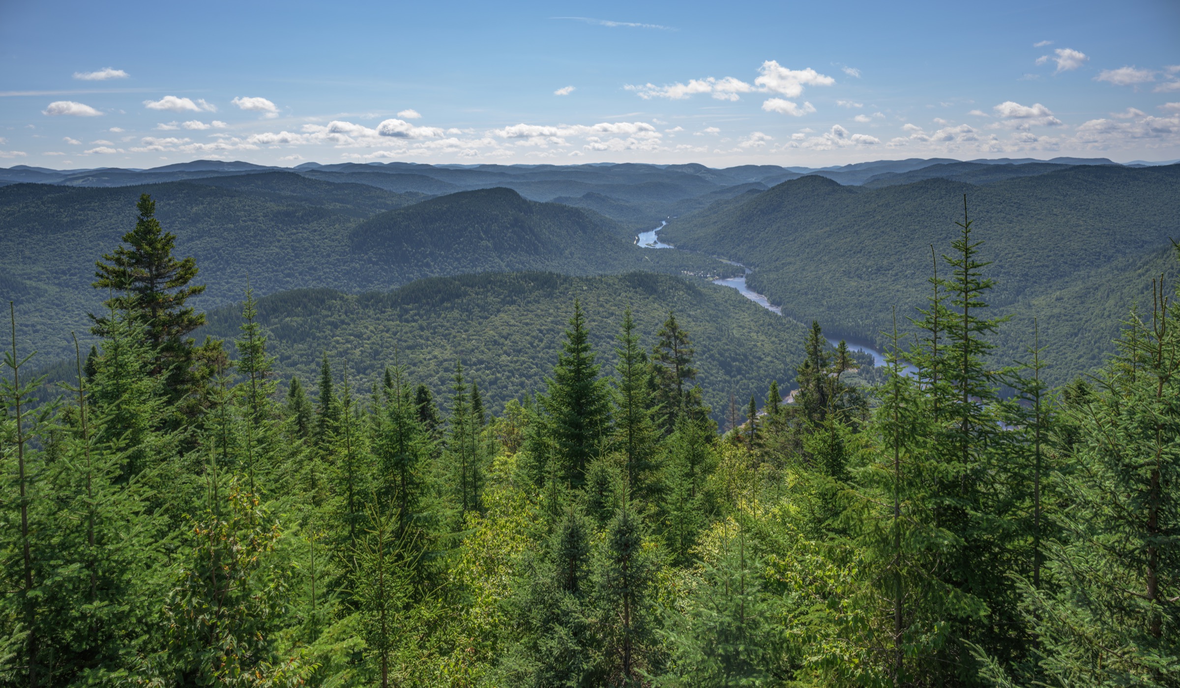
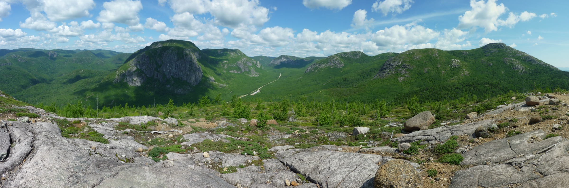
The trail leaves the rear of the Mont-du-Lac-des-Cygnes service centre at km 21 on Route 381 and climbs steadily through a mixed boreal forest of balsam fir, black spruce and white birch. The grade is consistent rather than punishing for the first 2 km, with sections of stone steps and rooted tread. In the upper third the path steepens significantly, with a long flight of wooden and stone steps that smooths what would otherwise be a steep scramble on slabby anorthosite bedrock. Above treeline the forest gives way to a krummholz of stunted spruce and then to true arctic-alpine vegetation — lichens, dwarf shrubs and cushion plants — colonising the exposed summit dome. From the 980 m top the panorama opens over Lac des Cygnes 660 m below, eastward across the Charlevoix astrobleme’s inner ring of mountains, north across the Grands-Jardins taiga plateau and south-east to the Saint Lawrence River and the Rivière du Gouffre valley. The descent retraces the same line.
Why it is essential
Mont du Lac des Cygnes is the signature summit of Grands-Jardins and one of the most iconic day-hikes in the Charlevoix region. It is the most accessible Québec summit where genuine arctic-alpine plant communities can be walked through, and the top offers the clearest single overview of the Charlevoix impact crater. It is the standard introduction to the park and is consistently cited as the headline hike by SEPAQ, Tourisme Charlevoix, Espaces and regional guidebooks.
Equipment
- Hiking boots or trail shoes with good grip on wet stone steps
- Trekking poles for the steep descent
- Weatherproof shell and warm layer (the summit can run 5–10 °C colder and windier than the trailhead)
- Sun protection
- 1.5–2 L water; no reliable source on the route
- Map (SEPAQ park map or Avenza geo-PDF)
- Microspikes and snowshoes in winter and shoulder season
- Insect repellent in June and early July (blackflies and mosquitoes)
Hazards and notes
- The summit is fully exposed; lightning risk during summer thunderstorms.
- Steep stair sections become slippery when wet or icy.
- Snow patches linger into late May.
- The trail can be busy on summer weekends; SEPAQ park-entry fee required.
- Black bears are present; standard food handling applies.
- Dogs are not permitted in SEPAQ parks.
- The arctic-alpine summit vegetation is fragile; stay on marked rock and boardwalk surfaces.
Routes and maps
| Source | URL |
|---|---|
| SEPAQ — Grands-Jardins hiking trails | sepaq.com |
| SEPAQ — Grands-Jardins visitor guide (PDF) | sepaq.com |
| OpenStreetMap — Mont du Lac des Cygnes | openstreetmap.org |
| AllTrails — Mont du Lac des Cygnes Summit | alltrails.com |
| Wikiloc — community tracks | wikiloc.com |
External links
- Wikipedia — Mont du Lac des Cygnes
- Géoparc de Charlevoix — Astrobleme view from Mont du Lac des Cygnes
- Espaces — Mont-du-Lac-des-Cygnes
- Tourisme Charlevoix — Parc national des Grands-Jardins
2. L’Acropole-des-Draveurs
Snapshot
Itinerary
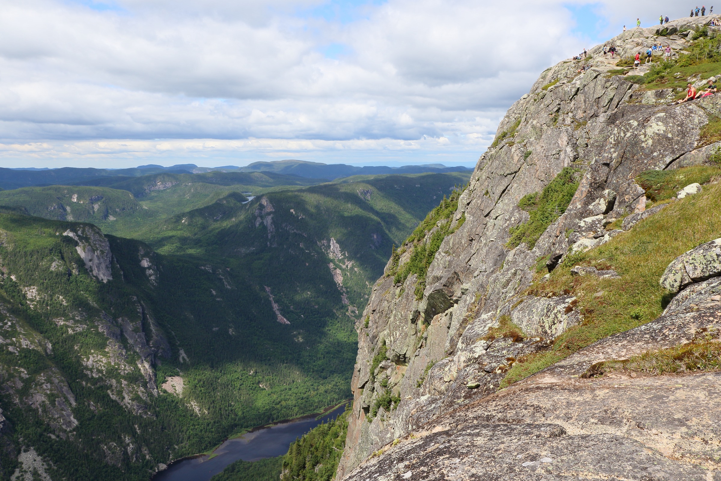
The trail leaves the Malbaie valley floor opposite the Pin-Blanc campground and immediately begins a sustained climb up the western flank of Montagne des Érables. The lower section ascends through mature mixed forest of sugar maple, yellow birch and balsam fir on a rooty, often stepped tread; the grade is unrelenting for the first 3–4 km. As the trail nears treeline the canopy opens onto a series of three successive rocky summits along the gorge rim, with the path stepping from one viewpoint to the next. The first summit is reached at roughly 5.2 km and delivers the headline view straight down into the Malbaie gorge and across to the cliffs of Cran des Érables. The second and third summits, slightly further along the ridge, extend the panorama and reach the highest point of the hike at 1,048 m on Montagne des Érables. Return is by the same route; the long descent is hard on knees.
The trail is closed each winter and reopens annually around the second Friday of June, once snow and runoff conditions allow. SEPAQ enforces a strict departure window: hikers may set out only between sunrise and 14:00, and between sunrise and 12:00 from 1 September.
Why it is essential
L’Acropole-des-Draveurs is the most famous day-hike in eastern Québec and the defining objective of Hautes-Gorges. It pairs the highest summit in the park with the most direct view down into a gorge whose walls rival anything east of the Canadian Rockies. SEPAQ, Tourisme Charlevoix, Espaces and every regional guidebook list it as the signature hike of Charlevoix; for many Québec walkers it is a once-in-a-lifetime, mythical trail.
Equipment
- Sturdy hiking boots with ankle support (recommended by SEPAQ)
- Trekking poles strongly recommended for the long descent
- Minimum 2 L water per person; no reliable source on the climb (refill at visitor centres)
- Weatherproof shell and warm layer; ridge exposure
- Sun protection
- Food for a full day
- Map (SEPAQ or the Avenza Maps “L’Acropole-des-Draveurs” geo-PDF)
- Insect repellent in June and early July
Hazards and notes
- Sustained climb; many parties underestimate the descent.
- Ridge sections are fully exposed to wind, sun and lightning.
- Snow patches and mud persist into early June.
- Departure cut-off is strictly enforced (14:00 in summer; 12:00 from 1 September).
- The free SEPAQ shuttle is required from the Félix-Antoine-Savard centre during summer high season; private vehicles are not permitted to the trailhead while the shuttle is operating.
- Black bears are present in the valley; SEPAQ food-storage rules apply.
- Dogs are not permitted in SEPAQ parks, including on the shuttle.
- Park gate / day-pass and shuttle reservation may be required; check the park access page before departure.
Routes and maps
| Source | URL |
|---|---|
| SEPAQ — Acropole-des-Draveurs important information | sepaq.com |
| SEPAQ — Hautes-Gorges visitor guide (PDF) | sepaq.com |
| Avenza Maps — Acropole-des-Draveurs geo-PDF | store.avenza.com |
| Trailforks — Acropole-des-Draveurs | trailforks.com |
| AllTrails — Acropole-des-Draveurs | alltrails.com |
External links
- SEPAQ — Parc national des Hautes-Gorges-de-la-Rivière-Malbaie
- Wikipedia — Hautes-Gorges-de-la-Rivière-Malbaie National Park
- Wikipedia — Montagne des Érables
- Tourisme Charlevoix — Acropole des Draveurs legendary hike
- Espaces — L’Acropole-des-Draveurs
3. Le Pioui (loop with Mont du Lac des Cygnes)
Snapshot
Itinerary
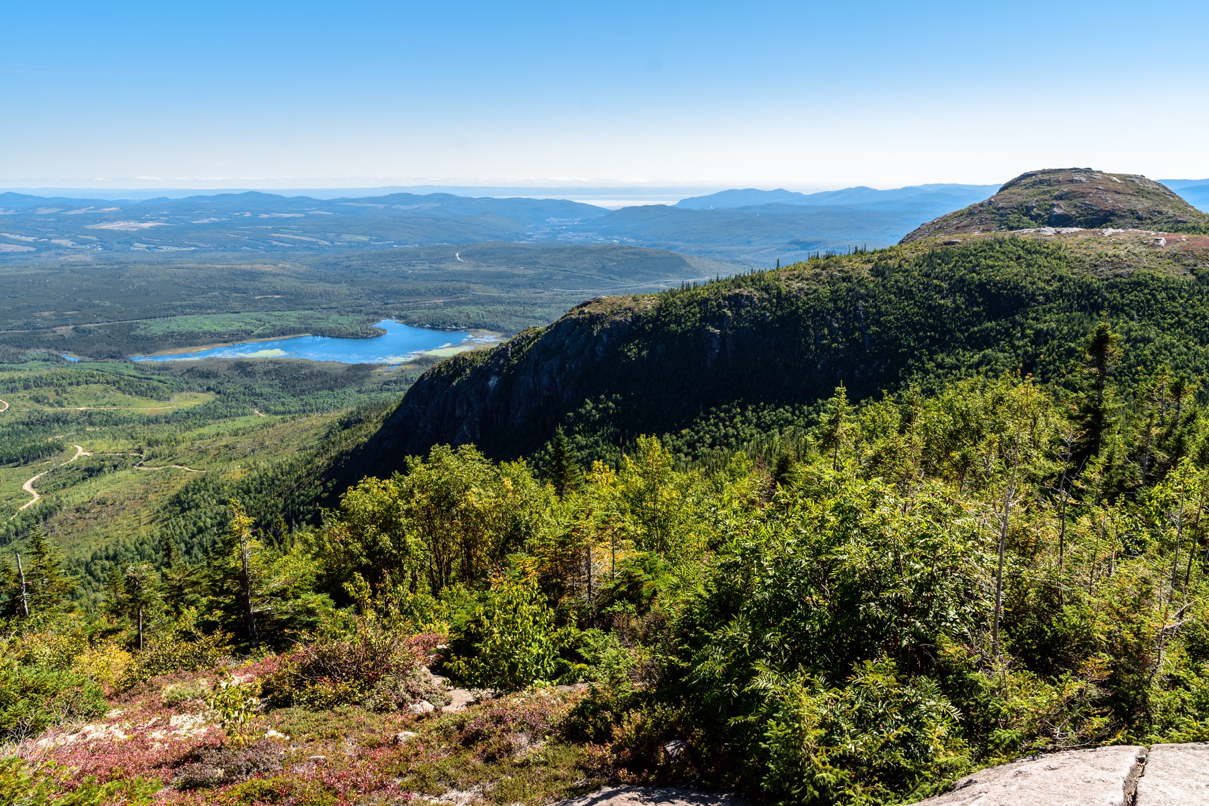
The Pioui trail leaves the same Mont-du-Lac-des-Cygnes service centre and climbs steeply for roughly 3 km on a technical tread of rocks and roots, gaining the ridge above Lac Pioui. The path then follows the open sub-alpine ridge of the Mont du Lac Pioui massif north-eastward, with intermittent panoramic windows over the Charlevoix astrobleme’s inner mountains and the surrounding taiga. The trail can be walked as a standalone 10.4 km loop, or extended over the summit of Mont du Lac des Cygnes for an 11–12 km combined ridge traverse with significantly more gain. After descending through sub-alpine forest, the path rejoins the lower trail network and returns to the service centre. The terrain is wilder and more lichen-dominated than the Mont du Lac des Cygnes path proper; bog-bridge, exposed bedrock and krummholz alternate across the ridge.
Why it is essential
Le Pioui delivers the longer, wilder ridge experience that complements the shorter and busier Mont du Lac des Cygnes climb. It crosses representative taiga and sub-alpine vegetation rarely accessible this far south, and the combined Pioui + Lac des Cygnes loop is one of the best single-day traverses in Québec for parties wanting a more sustained outing than the standard summit.
Equipment
- Sturdy boots; tread is rocky, rooted and technical
- Trekking poles
- Weatherproof shell and warm layer (ridge exposure)
- 2 L water; no reliable source on the ridge
- Sun protection
- Map; navigation is straightforward but signage assumes familiarity with the SEPAQ network
- Insect repellent through July
Hazards and notes
- The ridge is fully exposed to weather; thunderstorm risk in midsummer.
- The first 3 km is steep and technical; descent care is needed.
- Snow patches linger into early June on the upper ridge.
- Black bears are present.
- Dogs are not permitted.
- SEPAQ park-entry fee required.
Routes and maps
| Source | URL |
|---|---|
| SEPAQ — Grands-Jardins hiking trails | sepaq.com |
| SEPAQ — Grands-Jardins trail status (PDF) | sepaq.com |
| AllTrails — Le Pioui and Mont du Lac des Cygnes Loop | alltrails.com |
| Wikiloc — community tracks “Pioui” | wikiloc.com |
| OpenStreetMap — Grands-Jardins trails | openstreetmap.org |
External links
- Versant Plein Air — Sentier Pioui
- Dan en bottines — Boucle Pioui / Lac des Cygnes / Chouenne
- Seb’s Urban Adventures — Boucle Le Pioui et Mont-du-Lac-des-Cygnes
- Espaces — 5 plus belles randonnées du Parc national des Grands-Jardins
4. La Chouenne
Snapshot
Itinerary
The trail begins close to the southern entrance of Grands-Jardins on Route 381 and climbs steadily through a mixed forest of birch, maple and balsam fir. The grade is steady rather than punishing and the path is well graded with steps and short switchbacks. Within roughly an hour the trail emerges on a cliff-edge belvedere at the summit, where the bedrock drops away sharply to reveal a broad panorama south and east over the Rivière du Gouffre valley, the southern Charlevoix astrobleme, the Saint Lawrence River and (on clear days) the Île d’Orléans. Several viewpoints along the rim extend the panorama. Descent is by the same route.
Why it is essential
La Chouenne is the short-format companion to Mont du Lac des Cygnes: a low-commitment cliff-edge belvedere with one of the best panoramic views in southern Charlevoix. It is the standard family-friendly hike of Grands-Jardins, repeatedly listed as essential by Tourisme Charlevoix, Espaces and SEPAQ, and one of the few routes in the area that holds its character through all four seasons. It is also a key spring and autumn shoulder-season objective when higher trails are closed by snow or mud.
Equipment
- Hiking shoes or light boots
- Weatherproof layer and warm layer
- Water and a snack
- Microspikes or snowshoes in winter (the SEPAQ trail-status report confirms winter accessibility)
Hazards and notes
- The cliff-edge belvedere is unfenced; keep children close.
- Steep tread can be icy in the shoulder seasons.
- Black bears are present.
- Dogs are not permitted.
- SEPAQ park-entry fee required.
Routes and maps
| Source | URL |
|---|---|
| SEPAQ — Grands-Jardins hiking trails | sepaq.com |
| AllTrails — Sentier la Chouenne | alltrails.com |
| OpenStreetMap — La Chouenne area | openstreetmap.org |
| Wikiloc — community tracks “La Chouenne” | wikiloc.com |
External links
- Versant Plein Air — La Chouenne
- Espaces — 5 plus belles randonnées du Parc national des Grands-Jardins
- Gen-Hike — La Chouenne
- Tourisme Charlevoix — Parc national des Grands-Jardins
5. Le Riverain (to Le Yéti viewpoint)
Snapshot
Itinerary
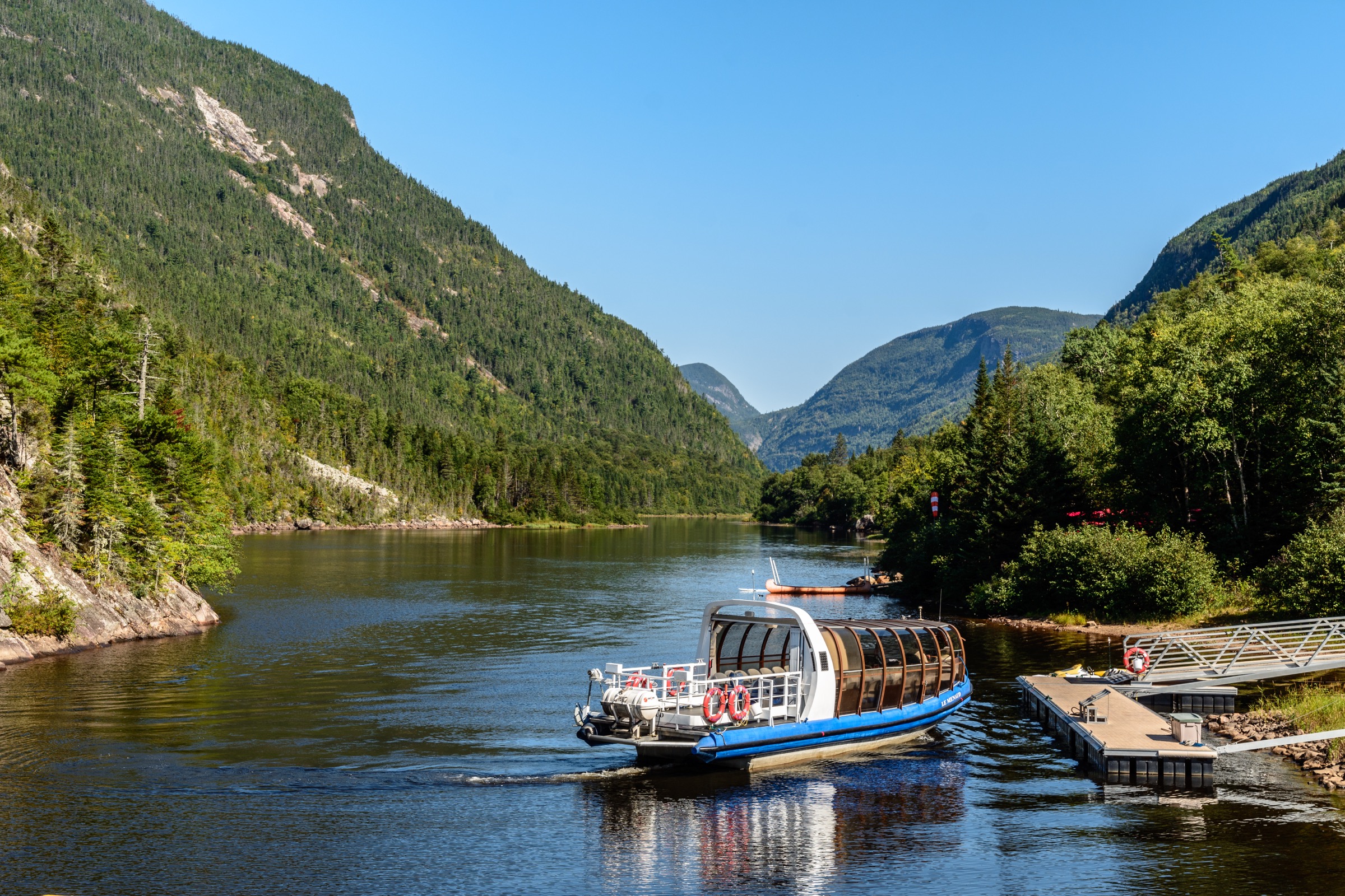
The trail leaves the Félix-Antoine-Savard service centre at the eastern end of the Malbaie valley and tracks the west bank of the Rivière Malbaie upstream on a wide, fine-gravel path. The first 4–5 km are nearly flat and deliver continuously changing views of the gorge walls — including the Cran des Érables cliffs directly across the river — without the climbing required by the Acropole. After approximately 6 km the trail forks: the main Riverain path continues to the Barrage des Érables (Maples Dam), while a short, steeper spur climbs Le Yéti viewpoint on the west wall of the gorge, roughly 400 m above the valley floor. From Le Yéti the panorama encompasses the full sweep of the upper Malbaie gorge, with the cliffs of L’Acropole-des-Draveurs directly opposite. Return is by the same route along the river.
A shorter variant called Le Riverain et les Rapides extends only to the rapids section closer to the visitor centre.
Why it is essential
Le Riverain delivers the gorge from below: the only way to walk the full length of the upper Malbaie valley floor with continuous views of the 800 m cliffs on both sides. It is the gentle, long-distance counterpoint to the Acropole climb and the standard non-strenuous gorge hike for visitors who cannot or do not want to commit to an 800 m vertical day. The short Le Yéti viewpoint spur adds a panoramic high point that captures the gorge from a perspective unavailable from the Acropole side.
Equipment
- Hiking shoes or trail shoes; the trail surface is wide gravel
- Trekking poles useful but not essential
- Weatherproof layer
- 1.5–2 L water
- Sun protection
- Insect repellent in June and July
- SEPAQ map of “Le Riverain (pt de vue Yéti) et Les Rapides” (Avenza geo-PDF available)
Hazards and notes
- Long route; pacing matters, especially in summer heat.
- The Le Yéti spur is steeper and rougher than the main path; the viewpoint is exposed.
- Black bears are present; SEPAQ food rules apply.
- Dogs are not permitted.
- The park typically closes 22 October and reopens around 20 April.
- Private vehicles are prohibited beyond Félix-Antoine-Savard centre in summer high season; use the free SEPAQ shuttle to inner trailheads if required.
- Park-entry fee required.
Routes and maps
| Source | URL |
|---|---|
| SEPAQ — Hautes-Gorges hiking trails | sepaq.com |
| SEPAQ — Hautes-Gorges visitor guide (PDF) | sepaq.com |
| Avenza Maps — Le Riverain (pt de vue Yéti) et Les Rapides | store.avenza.com |
| AllTrails — Le Riverain | alltrails.com |
| Trailforks — Sentier Le Riverain | trailforks.com |
External links
- SEPAQ — Parc national des Hautes-Gorges-de-la-Rivière-Malbaie
- Dan en bottines — Sentier Le Riverain / Point de vue Le Yéti
- Seb’s Urban Adventures — Le Riverain
- Défi des 5 sommets — Le Yéti (Sentier le Riverain)
- Tourisme Charlevoix — 5 great hikes the whole family will enjoy
External links
- SEPAQ — Parc national des Grands-Jardins
- SEPAQ — Parc national des Hautes-Gorges-de-la-Rivière-Malbaie
- Géoparc de Charlevoix — Charlevoix astrobleme
- Tourisme Charlevoix — Hautes-Gorges-de-la-Rivière-Malbaie
- Espaces — 5 meilleures randonnées du parc des Hautes-Gorges
- Wikipedia — Hautes-Gorges-de-la-Rivière-Malbaie National Park
- Wikipedia — Parc national des Grands-Jardins (FR)