Regional overview
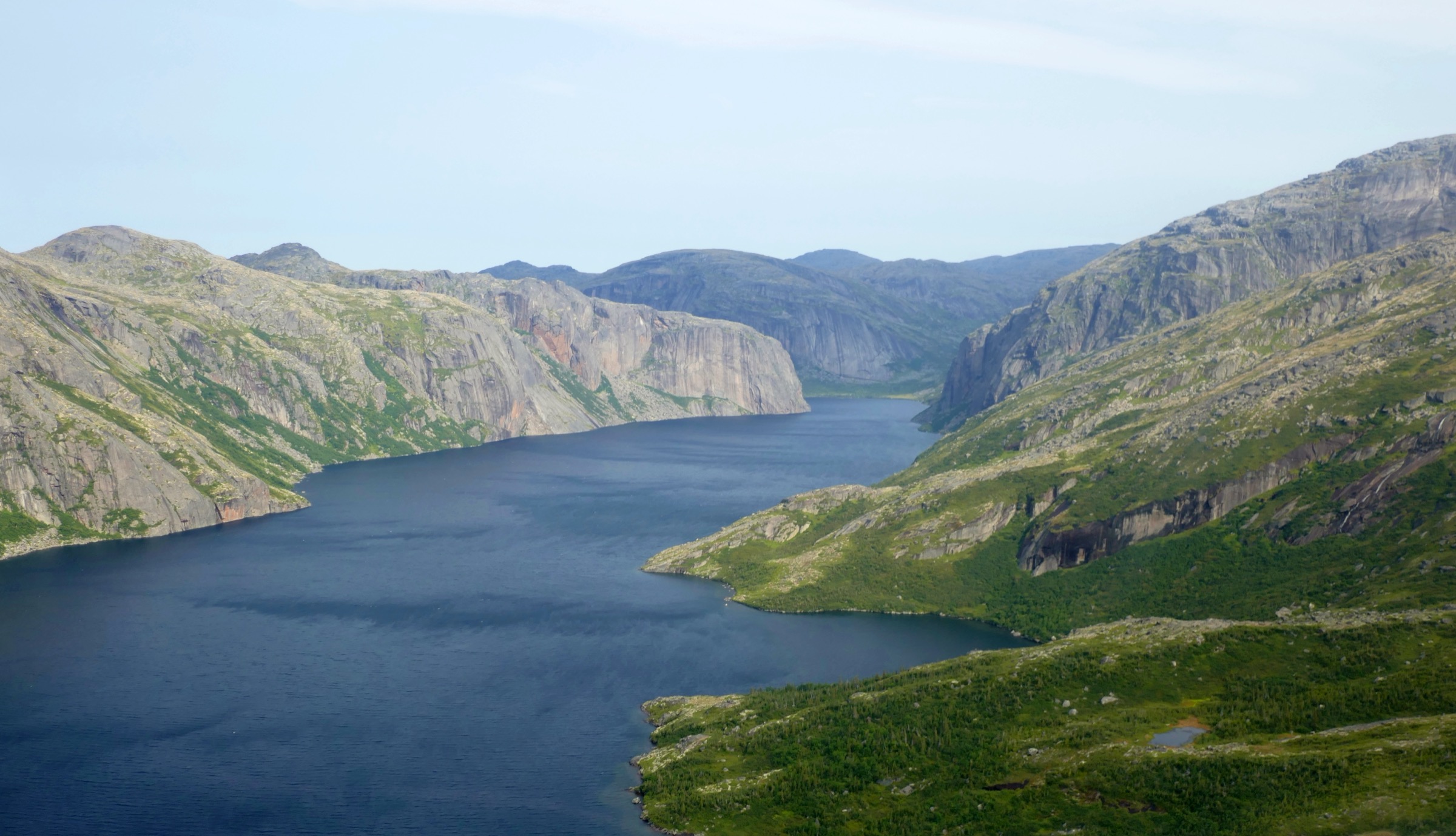
The Kiglapait Mountains are a compact, sharply serrated range on the northern Labrador coast about 50 km north of Nain. The name comes from the Inuktitut Kiglapait, “dog-tooth,” for the line of jagged summits seen from the sea. The range sits between the lower Aupalukitak hills to the south, the Kaumajet block across Okak Bay to the north, and Tikkoatokak Bay and Mugford Tickle to the east. The highest summits — Man O’War Peak (1,050 m), Peak 3400 (1,036 m), Peak 3300 (1,006 m), Mount Thoresby (~914 m) and Aupalukitak Mountain (914 m) — rise abruptly from saltwater and present some of the highest prominence-to-base ratios in the Canadian Shield. The range coordinates are approximately 57°06′N 61°35′W.
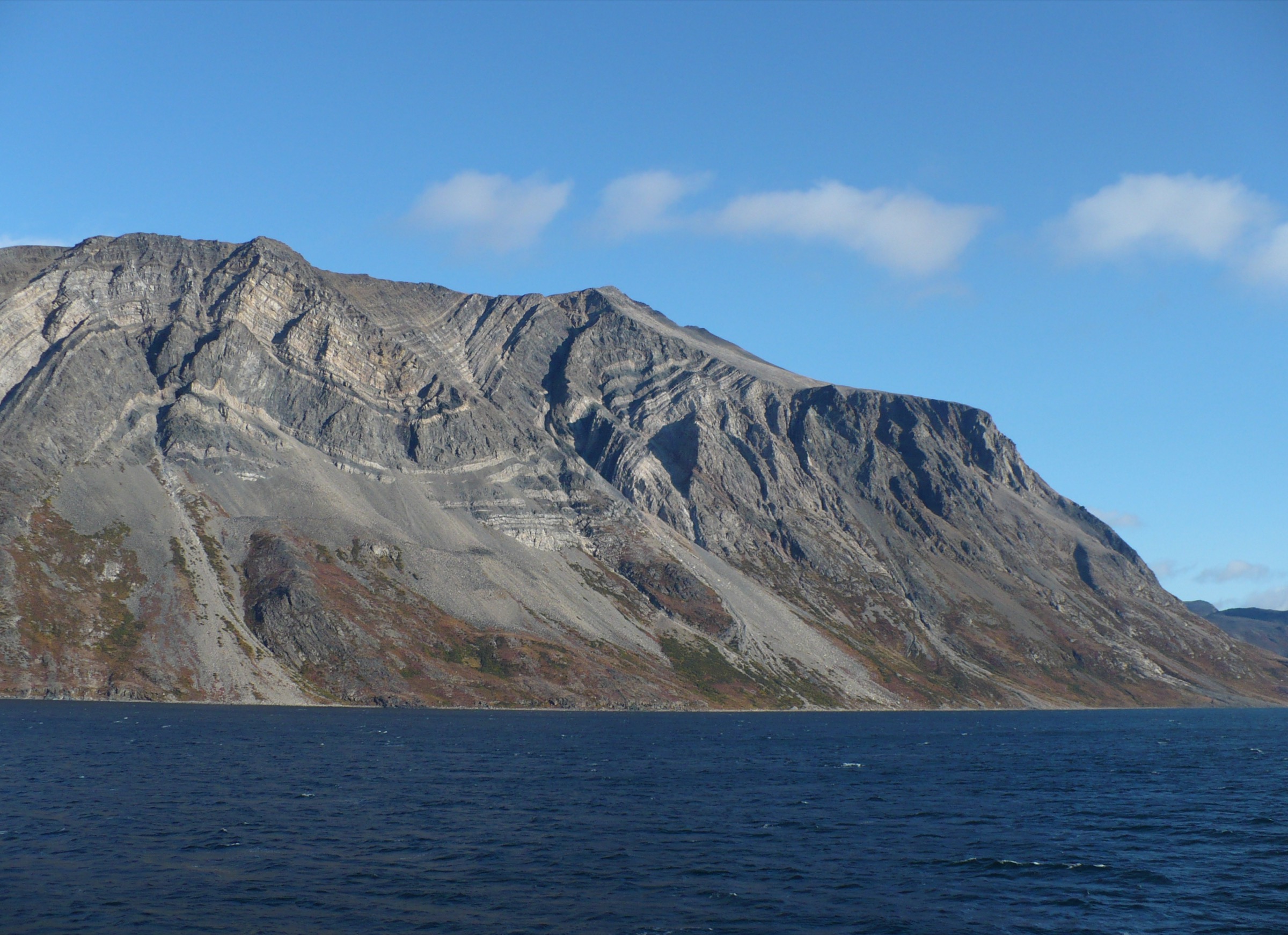
The geological framework of the range is the Kiglapait Intrusion — a 1,290-million-year-old layered troctolite intrusion about 85 km in length, exposed along the coast and one of the most studied layered mafic intrusions in the world (the type-area for several modern theories of magma-chamber crystallisation). The intrusion’s banded outcrops dominate the coastline from Tikkoatokak Bay south to Village Bay.
There are no settlements, roads, marked trails, or commercial accommodation in the Kiglapait. The closest settlement is Nain (population ~1,200), about 50 km south by sea. The standard approach is chartered boat from Nain — Air Borealis flies Goose Bay–Nain three days a week — or floatplane direct to one of the interior lakes from Goose Bay. The traditional staging point for climbing trips on Man O’War Peak and the central intrusion is a campsite at the head of Village Bay, on the south-east flank of the range. Sea-kayak parties typically work north from Nain along the coast in 5–7 days, putting in for day-walks from camp.
The walking season is mid-July to mid-September. Pack ice may block the inshore zone into early July, and autumn storms close the coast from mid-September. Polar bears are present on the coast year-round and remain the primary safety concern; black bear and wolf are also active in the lower valleys. Caribou (the northern Labrador herd) cross the inland tundra in late summer. The interior plateau holds light snow well into July and has been recorded with overnight frost in any summer month. There is no mobile coverage; satellite-messenger or HF radio is mandatory.
The Kiglapait are not formally protected and have no managed-park infrastructure. All five walks below are framed as candidate routes from coastal landings; none has a published or maintained track. Trip planning should be done with a qualified Nunatsiavut Inuit guide and registered with the Nunatsiavut Government.
Selection rationale
There are no established trails in the Kiglapait Mountains. The five walks below are picked to cover the range’s representative landscapes — the central high block at Man O’War Peak, the southern summit cluster at Mount Thoresby, the Aupalukitak ridge, the shore exposures of the Kiglapait Intrusion, and the upland tundra above Tikkoatokak / Village Bay. All are described as candidate routes; specific tracks must be confirmed with a local guide.
Summary table
| # | Hike | Country | Route type | Distance | Gain | Max elevation | Difficulty |
|---|---|---|---|---|---|---|---|
| 1 | Man O’War Peak shoulder walk | Canada | Out-and-back | 8-12 km | ~800-900 m | ~900-950 m | Strenuous |
| 2 | Mount Thoresby viewpoint walk | Canada | Out-and-back | 6-10 km | ~700-850 m | ~914 m | Strenuous |
| 3 | Aupalukitak Mountain ridge walk | Canada | Out-and-back | 8-12 km | ~700-900 m | ~914 m | Strenuous |
| 4 | Kiglapait Intrusion shore-geology walk | Canada | Linear / out-and-back | 6-10 km | ~150-250 m | ~250 m | Moderate |
| 5 | Village Bay tundra walk above Tikkoatokak | Canada | Out-and-back | 6-10 km | ~300-500 m | ~600 m | Moderate |
1. Man O’War Peak shoulder walk
Snapshot
Itinerary
From a camp at the head of Village Bay on the south-east side of the range, the walking line climbs the broad lower valley north-west onto an open scree shoulder of Man O’War Peak at about 900–950 m. The shoulder gives the highest accessible day-walk vantage in the Kiglapait without crossing into class 3+ scrambling on the summit pyramid itself. The route is off-track throughout, on Kiglapait Intrusion troctolite scree above the treeline.
Why it is essential
Man O’War Peak is the highest mountain in the Kiglapait at 1,050 m and the namesake summit of the range. The south-east shoulder reaches the upper-tundra zone of the central block, from which the line of “dog-tooth” summits north along the spine of the range can be seen at close quarters, with Okak Bay and Cod Island beyond.
Equipment
- Mountaineering boots
- Helmet
- Full waterproof and insulation layers
- Bivvy bag
- Bear-deterrent spray; firearm under guide
- Map, compass, GPS, satellite messenger
- 3 litres of water
Hazards and notes
- Polar bear risk on the approach from the coast
- Loose scree on the upper shoulder
- Sea-fog can close in within minutes
- Boat pickup weather-dependent
- A qualified Labrador-coast guide is mandatory
GPX / KML links
No open route file located. Man O’War Peak approximately 57.13°N, 61.65°W.
External links
2. Mount Thoresby viewpoint walk
Snapshot
Itinerary
From a south-east coastal landing, the walking line climbs the open lower slopes onto a tundra shelf and continues to the south shoulder of Mount Thoresby at about 914 m. The summit pyramid itself is a short class 2–3 scramble that can be added or skipped depending on conditions. Descent retraces the ascent route.
Why it is essential
Mount Thoresby is one of the named summits of the southern Kiglapait and gives the most accessible high-vantage view back into Village Bay, south toward Nain across Tikkoatokak Bay, and north along the spine of the range. The route covers the most representative cross-section of Kiglapait Intrusion outcrops on a single day.
Equipment
- Stiff hiking or mountaineering boots
- Helmet
- Full waterproof and insulation layers
- Bear deterrent
- Map, compass, GPS, satellite messenger
- 3 litres of water
- Bivvy bag
Hazards and notes
- Polar bear risk on the coast
- Loose rock and scree on the upper shoulder
- Sea-fog and sudden temperature drops
- Boat pickup weather-dependent
- Qualified guide strongly recommended
GPX / KML links
No open route file located. Mount Thoresby approximately 57.08°N, 61.55°W.
External links
3. Aupalukitak Mountain ridge walk
Snapshot
Itinerary
Aupalukitak Mountain (914 m, “red shining” in Inuktitut) lies on the southern edge of the Kiglapait above Tikkoatokak Bay. From a south-coast landing, the walking line climbs the broad lower slopes and follows the open ridge crest north to the summit shoulder, with steady views south to Nain and east to the Labrador Sea. The route is off-track and stays mostly above the treeline.
Why it is essential
The Aupalukitak ridge gives the most southern viewpoint of the range and the best continuous panorama of the Kiglapait line from a single ridge walk. The reddish-tinted gabbroic rock that gives the mountain its name is part of the southern boundary of the Kiglapait Intrusion.
Equipment
- Stiff hiking boots
- Helmet
- Full waterproof and insulation layers
- Bear deterrent
- Map, compass, GPS, satellite messenger
- 3 litres of water
Hazards and notes
- Polar bear and black bear active on the approach
- Loose scree on the upper slopes
- Sustained wind on the ridge
- Boat pickup weather-dependent
- Qualified guide strongly recommended
GPX / KML links
No open route file located. Aupalukitak Mountain approximately 57.00°N, 61.65°W.
External links
4. Kiglapait Intrusion shore-geology walk
Snapshot
Itinerary
The Kiglapait Intrusion outcrops continuously along the south-east coast of the range. The walking line uses a boat landing at the south end of the exposure, follows the rocky shore north past banded troctolite and anorthosite outcrops, climbs a low bench for the cross-section view, and continues to a pickup further north. The walking is on coastal rock, low scrub and short tundra benches.
Why it is essential
The Kiglapait Intrusion is one of the world’s most studied layered mafic intrusions and a type-section for crystallisation theory. The south-east coast walk gives the longest accessible cross-section of the layered sequence at sea level, exposing 1,290-million-year-old magmatic banding in continuous outcrop. The route is the only Kiglapait day-walk that is dominated by geology rather than altitude.
Equipment
- Hiking shoes / boots
- Wind- and waterproof shell
- Insulation layer
- Bear deterrent
- Map, compass, GPS, satellite messenger
- 2 litres of water
- Hand lens for outcrop work
Hazards and notes
- Polar bear risk; never walk alone
- Wet shore boulders are slippery
- Boat pickup weather-dependent
- Geological hammers are restricted in some Nunatsiavut Inuit cultural-use areas; confirm with guide before sampling
GPX / KML links
No open route file located. South-east coast of the intrusion approximately 57.10°N, 61.50°W.
External links
5. Village Bay tundra walk above Tikkoatokak
Snapshot
Itinerary
The traditional Inuit hunting camp at the head of Village Bay is the standard climbing-trip staging area for Man O’War Peak and the central Kiglapait. The shorter day-walk from camp climbs the open lower valley west onto a tundra shelf at about 600 m, with views back over Village Bay and south across Tikkoatokak Bay to Nain on a clear day. The route is off-track and avoids the steeper scree above the shelf.
Why it is essential
This is the lowest-stakes day-walk in the Kiglapait and a standard rest-day route from the Village Bay camp. The tundra shelf is excellent for caribou-watching in late summer and gives the best low-altitude view of the central Kiglapait summits without committing to a high summit attempt.
Equipment
- Stiff hiking boots
- Wind- and waterproof shell
- Insulation layer
- Bear deterrent
- Map, compass, GPS, satellite messenger
- 2 litres of water
Hazards and notes
- Polar bear and black bear both possible
- Boggy ground on the lower shelf in wet years
- Sea-fog can close in quickly
- Village Bay is a sensitive Inuit cultural-use area; respect guide protocols
GPX / KML links
No open route file located. Village Bay head approximately 57.05°N, 61.55°W.