Regional overview
The Omineca Mountains form a roughly 47,900 km² block of the Interior Mountains of north-central British Columbia, bounded by the Finlay River to the north, the Rocky Mountain Trench (filled by the Williston Lake reservoir) to the east, the Nation Lakes to the south, and the upper Omineca River to the west. The range comprises the Swannell Ranges (including the Wolverine, Ingenika and Tucha subranges), the Hogem Ranges (Connelly, Mitchell, Sikanni, Axelgold and Cariboo Heart), the Finlay Ranges (Russel and Butler), the Tatlatui Range, the Metsantan Range and the Samuel Black Range. The highest commonly cited point is approximately 2,400 m, with Sustut Peak in the northern Connellys at 2,475 m. The Ominecas sit between the Nechako Plateau to the south, the Skeena and Hazelton Mountains to the west, and the Spatsizi Plateau and Stikine Ranges to the north.
Hiking infrastructure is extremely sparse. Outside the immediate Fort St. James area, the Ominecas contain almost no marked, maintained day-hike trails. BC Parks describes Sustut Provincial Park, Tatlatui Provincial Park and Omineca Provincial Park as wilderness reserves with no developed trail systems; access to Sustut and Tatlatui is essentially by floatplane only, and Omineca Park is reached via long industrial gravel roads from Mackenzie or Fort St. James. The two practical road-access bases for visitors are Fort St. James (Highway 27, on Stuart Lake) and Mackenzie (Highway 39, on Williston Lake). A handful of front-country viewpoints — Mount Pope above Stuart Lake, Murray Ridge above Fort St. James and Morfee Mountain above Mackenzie — provide the only routinely day-hiked summits with usable signage and trailheads. Morfee Mountain is technically catalogued in the Misinchinka Ranges of the Hart Ranges (Northern Rocky Mountains) rather than the Ominecas, but Mackenzie sits in the structural saddle between the two ranges and Morfee is the standard panoramic viewpoint over Williston Lake and the Omineca front.
The hiking season is short. Snow typically lingers in the high country until late June or early July, and fresh snow can occur on summits from mid-September. The reliable summer hiking window is roughly early July to mid-September. Black bears and grizzly bears are both present throughout the region in significant numbers, including in the front-country viewpoints and ski-area trail networks; bear-aware practice — noise, group travel, secure food storage, bear spray — is appropriate on every route in this entry. Mosquitoes and black flies are heavy in early summer. Many trailheads sit on industrial Forest Service Roads with active logging traffic, where calling channel updates and high-clearance vehicles are commonly required. Cell coverage is unreliable away from the towns and absent in the protected areas; satellite communication is recommended for the more remote candidate routes below.
Selection rationale
Genuine essential day-hikes in the Ominecas are few. The five entries below have been chosen to reflect what is achievable in the region rather than to manufacture a polished top-five list:
- Mount Pope Summit Trail — the unambiguous front-country classic and the only marked, maintained, day-feasible summit trail in the southern Omineca front.
- Mount Pope T-Caves loop variant — the natural full-mountain alternative, combining the summit trail with the climbers’ approach trail past the limestone caves on the lower slopes.
- Murray Ridge summer summit ramble — the only other Fort St. James-area summit with a viable summer access, using the ski area’s lift-line and access road corridor.
- Morfee Mountain summit road and ridge — the standard Mackenzie front-country viewpoint over Williston Lake and the eastern Omineca front, included with a geographic caveat.
- The Thumb, Sustut Provincial Park — the only nationally notable named feature in the central Ominecas, presented honestly as a fly-in wilderness objective with a day-hike summit component.
Several frequently mentioned candidates were excluded. Mount Sir Alexander is a 3,275 m glaciated mountaineering objective in the Northern Continental Ranges of the Rockies, not in the Ominecas, and is not a day hike under any reasonable definition. Mount Carrie could not be verified as a peak in the Mackenzie / Omineca area in the underlying research. Mount Milligan is a porphyry copper-gold mine site with no recreational summit trail. The Omineca Park / Manson Creek-area historic routes are described by BC Parks as undeveloped and unmapped, with no verifiable day-hike section identified.
Summary table
| # | Hike | Country | Route type | Distance | Gain | Max elevation | Difficulty |
|---|---|---|---|---|---|---|---|
| 1 | Mount Pope Summit Trail | Canada | Out-and-back | ~13 km | ~790 m | ~1,463 m | Moderate–strenuous |
| 2 | Mount Pope T-Caves loop variant | Canada | Loop | ~13–15 km | ~790–850 m | ~1,463 m | Moderate–strenuous |
| 3 | Murray Ridge summer summit ramble | Canada | Out-and-back | ~6–10 km | ~530 m | ~1,231 m | Moderate |
| 4 | Morfee Mountain summit road and ridge | Canada | Out-and-back / drive-and-walk | ~5 km on foot (upper); ~29 km full road | ~400–800 m on foot | ~1,775 m | Easy–moderate on foot |
| 5 | The Thumb, Sustut Provincial Park | Canada | Fly-in wilderness scramble | ~5–10 km day component | ~600–900 m | ~1,848 m | Strenuous wilderness |
1. Mount Pope Summit Trail

Snapshot
Itinerary
The route begins at the signed trailhead on Stones Bay Road, reached by driving north out of Fort St. James on Stuart Drive W (which becomes Highway 27) and turning west on Stones Bay Road; the parking lot lies approximately 4 km along on the right. The trail enters second-growth conifer forest and climbs steadily by switchback up the southeast flank of the mountain, with a well-groomed pine-needle tread and no significant exposure on the lower kilometres. Roughly 4 km up, the climbers’ access trail (the “old trail” or T-Caves trail) joins from the right at a marked junction; the main route continues left up the broader summit ridge.
The grade eases through subalpine forest in the upper third of the route before the trail emerges above treeline onto a rocky knob occupied by a wooden gazebo at the site of a former forestry fire lookout. The summit offers a 360-degree panorama: Stuart Lake stretching southwest, the Nechako Plateau to the south, the Swannell and Hogem ranges of the Ominecas to the north, and the southernmost Skeena Mountains across the lake to the west. Return is by the ascent route.
Why it is essential
Mount Pope is the only marked, maintained, day-feasible summit trail in the southern Omineca front, and is the standard introductory hike for visitors basing in Fort St. James. The summit provides one of the most accessible panoramic vantages of the Omineca range. The trail is documented by BC Parks, the District of Fort St. James and multiple independent guides, and is the only Omineca-area route consistently recommended by regional tourism material as a single-day objective. Published summit elevations differ — ~1,420 m, 1,463 m and 1,467 m appear across reference sources — and the BC Parks page does not state a precise figure.
Equipment
- Sturdy boots, weatherproof and warm layers, navigation backup, sun protection and food.
- A minimum of 2 L of water per person; BC Parks notes no potable water on the trail.
- Bear spray and bear-aware food storage; black and grizzly bears both use the mountain.
- Trekking poles for the steeper switchback sections.
- Headtorch for late starts; microspikes in shoulder season for lingering snow patches on the upper section.
Hazards and notes
- Black and grizzly bears are common; the trail crosses active wildlife habitat. Cougars are also present in the wider area.
- No water on the route. Overnight camping is prohibited within the park.
- The summit gazebo provides limited shelter but no facilities.
- Cellular coverage is unreliable above the lower switchbacks.
- The trail is shared with descending mountain bikers and, in winter, snowshoers.
- The access road off Stones Bay Road is paved/maintained close to town; remote Omineca FSRs are not relevant to this trailhead but apply to other entries below.
- The trail crosses unceded territory of the Nak’azdli Whut’en First Nation; respectful use is expected.
GPX / KML links
| Source | URL | Format / access | Reuse status |
|---|---|---|---|
| BC Parks: Mount Pope Park | bcparks.ca | Park page with trailhead coordinates | BC Parks page; no official open GPX |
| OpenStreetMap | openstreetmap.org | OSM XML / GPX export | ODbL; reusable with attribution |
| Trailforks: Mount Pope Trail | trailforks.com | Community trace (account required) | Trailforks terms apply; reference only |
| Gaia GPS: Mount Pope | gaiagps.com | Subscription GPX | Gaia terms; reference only |
External links
- BC Parks — Mount Pope Park
- District of Fort St. James — Mount Pope Provincial Park
- iHikeBC — Mount Pope Trail Hike
- Peakbagger — Pope Mountain
2. Mount Pope T-Caves loop variant
Snapshot
Itinerary
The variant uses the standard summit trail described in Hike 1 for the ascent, then descends via the older climbers’ access trail signed on Trailforks as “Old trail (aka climbers)”. From the main summit trail, after returning from the gazebo, the climbers’ trail branches off at the marked junction roughly 2.5 km below the summit and drops more directly down the southeast slope through limestone bands.
The T-Caves area — a band of karst features and short cave entrances developed in the mountain’s limestone — lies on the lower flank and is the principal interest of this trail. The Mount Pope rock-climbing area, with approximately 39 documented routes, is centred on the same band. The climbers’ trail rejoins the main trail and access road system near the trailhead. The loop adds modest distance and a more interesting return than the standard out-and-back but is not formally signed as a loop and requires reasonable route-finding judgement.
Why it is essential
The T-Caves variant is the only documented loop option on Mount Pope and adds the mountain’s distinctive limestone karst geology to the summit experience. It is the form of the hike most often used by Fort St. James climbers and is the only way to see both the panoramic summit and the lower-slope cave features in a single day.
Equipment
- As for Hike 1, plus a headtorch useful at any short cave entrance.
- Trekking poles for the steeper, looser climbers’ trail descent.
- Helmet recommended if approaching active climbing routes, owing to rockfall potential from parties above.
- Bear spray, food, water (no source on route), sun protection and layers.
Hazards and notes
- The climbers’ trail is rougher, steeper and less maintained than the main summit trail.
- Route-finding is required at the upper junction and at cave-area branches.
- Rockfall hazard exists where active climbing routes overhang the trail.
- Bear, cougar and weather considerations are identical to Hike 1.
- Cave entrances are not developed and should not be entered without caving equipment and experience.
- Dogs may have difficulty on the steeper sections.
GPX / KML links
| Source | URL | Format / access | Reuse status |
|---|---|---|---|
| Trailforks: Mt. Pope Provincial Park region | trailforks.com | Region map (account required) | Trailforks terms; reference only |
| Trailforks: Old trail (aka climbers) | trailforks.com | Community trace | Trailforks terms; reference only |
| OpenStreetMap | openstreetmap.org | OSM XML / GPX export | ODbL; reusable with attribution |
| RockClimbPG: Mt. Pope | rockclimbpg.ca | Page text and approach diagrams | All rights reserved; reference only |
External links
- Trailforks — Mt. Pope Provincial Park
- AllTrails — Mount Pope T-Caves
- RockClimbPG — Mt. Pope
- BC Parks — Mount Pope Park
3. Murray Ridge summer summit ramble
Snapshot
Itinerary
In summer, the Murray Ridge Ski Area is closed and the lifts do not operate, but the access road, T-bar lift line and downhill ski runs provide a hikeable corridor to the ridge summit. From the base lodge at 700 m, the route follows the lower runs and service roads northeast up the cleared lift-line corridor, gaining the ridge at around 1,231 m. The summit ridge offers an open view south over Stuart Lake and Fort St. James and a broader panorama over the southern Omineca front.
Descent is by the same corridor. Approximately 20 km of cross-country ski trails adjacent to the alpine area provide alternative lower-elevation loops in summer where they remain identifiable. Murray Ridge is not formally promoted by the Fort St. James District as a summer hiking destination; summer use is informal and at the user’s risk.
Why it is essential
Murray Ridge is the second of the two Fort St. James-area summits that can plausibly be walked in a day, and is the only one that uses the local ski-area infrastructure. The ridge is the principal local-recreation feature of the southern Omineca front and is included here to balance the catalogue with a non-park, working-landscape route that represents the day-to-day hiking character of the area.
Equipment
- Sturdy boots, weatherproof and warm layers.
- Navigation: GPS recommended as no summer trail is signed.
- Sun protection, water (no on-route source in dry conditions) and food.
- Bear spray and bear-aware practice; black and grizzly bears commonly feed on the cleared ski runs.
- Trekking poles useful on the steeper run sections.
Hazards and notes
- No summer trail is signed or maintained; route-finding skill required.
- Active maintenance work or contractor traffic may be present on the access road and runs during the snow-free months.
- The ski area is private land operated by the Fort St. James Ski Club on unceded Nak’azdli territory; summer access permission should be confirmed locally before departure.
- Black and grizzly bears commonly use cleared ski runs as feeding corridors.
- Cellular coverage is intermittent.
- Wildfire smoke can be a significant issue in midsummer.
- Dogs are not formally restricted but on-leash practice is appropriate.
GPX / KML links
| Source | URL | Format / access | Reuse status |
|---|---|---|---|
| Murray Ridge Ski Area | murrayridge.com | Winter trail map PDF | All rights reserved; indicative geometry only |
| OpenStreetMap | openstreetmap.org | OSM XML / GPX export | ODbL; reusable with attribution |
| District of Fort St. James: Murray Ridge | fortstjames.ca | Page reference | Site terms apply |
External links
- Murray Ridge Ski Area
- District of Fort St. James — Murray Ridge Ski Area
- Wikipedia — Murray Ridge Ski Area
- District of Fort St. James — All-Season Recreation
4. Morfee Mountain summit road and ridge
Snapshot
Itinerary
The Morfee Mountain Road leaves Highway 39 approximately 1 km north of Mackenzie at a signed parking area with a sled ramp. The road climbs steadily by switchback up the south face of the mountain. A high-clearance vehicle can drive most of the way to the summit ridge under summer conditions; trucks, ATVs and dirt bikes share the road. The standard summer day-walk variant drives to a high pull-out and then walks the remaining road or open ridge to the radio installations on the summit at ~1,775 m.
The summit provides an open view east over the Hart Ranges of the Rockies, west over Williston Lake and the Omineca front (the Swannell Ranges across the lake), and south over the Parsnip Reach. The 14 km Morfee Mountain Downhill mountain-bike system opened in 2023 and shares the descent corridor with shuttle-supported riders; hikers should yield to descending bikes. The full road climb on foot is feasible but rarely done as a hike; most visitors drive most of the elevation.
Why it is essential
Morfee Mountain is the standard Mackenzie front-country viewpoint and provides the only easily reached panoramic overlook of Williston Lake and the eastern Omineca front. While the peak itself is not strictly in the Ominecas — it sits in the Misinchinka Ranges of the Hart Ranges — it is the route a Mackenzie-based visitor will use to obtain a regional overview of the Ominecas, and Mackenzie tourism material consistently markets the mountain in this role. Including it with the geographic caveat is more useful than omitting it.
Equipment
- Sturdy footwear, weatherproof and warm layers; the summit ridge is exposed and 1,000 m higher than the town.
- Water, food, navigation and sun protection.
- Bear spray.
- Hi-vis or bright colours useful given shared motorised use of the road in summer.
- A vehicle with reasonable clearance for the road approach.
Hazards and notes
- Active motorised use of the road by trucks, ATVs and dirt bikes in summer; downhill mountain bikes from the 2023 shuttle system descend the main ridge-line route at speed.
- The road is an industrial-style access route subject to summer washouts and dust; pre-trip checks with local operators are sensible.
- The summit is exposed to weather and lightning.
- Bears (black and grizzly) are common on the lower forested sections of the road.
- Wildfire smoke can be a significant midsummer issue.
- The summit installations are working communications infrastructure; do not enter fenced areas.
- Cellular coverage is reasonable on the upper ridge due to the installations but cannot be relied upon.
- Dogs should be leashed given the road’s motorised use.
- Range-attribution caveat: Morfee is in the Hart Ranges per Wikipedia and PeakVisor, not strictly in the Ominecas.
GPX / KML links
| Source | URL | Format / access | Reuse status |
|---|---|---|---|
| Trailforks: Morfee Mountain Road | trailforks.com | Community trace | Trailforks terms; reference only |
| Trailforks: Morfee Mountain region | trailforks.com | Region map | Trailforks terms; reference only |
| OpenStreetMap | openstreetmap.org | OSM XML / GPX export | ODbL; reusable with attribution |
| MORATA — Mackenzie Outdoor Route & Trail Association | morata.ca | Project descriptions | Site terms apply |
External links
- Wikipedia — Mount Morfee
- District of Mackenzie — Parks, Playgrounds, Trails
- Mackenzie Chamber of Commerce — Things to See and Do
- Mountain Biking BC — Mackenzie
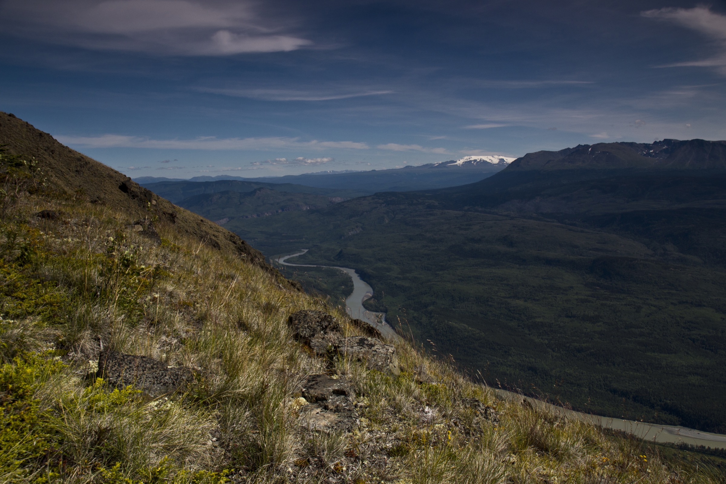
5. The Thumb, Sustut Provincial Park
Snapshot
Itinerary
Sustut Park has no road access and no developed trails. The Thumb is the highest of the four named peaks in the park and the most-cited individual objective: an active fumarole on a basaltic escarpment, approximately 2.4 m high with a depression in the top from which carbon dioxide emanates. First Nations knowledge of the feature long predates the geological literature; the Sekani noted that birds flying over the fumarole are killed in mid-air, an account consistent with the CO₂ emissions.
Access is by floatplane to one of the park’s lakes. Operators are limited to permitted air charter companies; historically Tsayta Aviation Ltd. has operated out of Fort St. James, and Alpine Lakes Air Ltd. has operated out of Telkwa. From the lakeside camp, the summit day involves an off-trail approach across subalpine and alpine terrain to the base of The Thumb, then a short scramble to the cone. Exact distance and gain depend on the chosen drop-off. The route is not described in detail in publicly available trip reports.
Why it is essential
The Thumb is the only nationally notable named feature in the central Omineca Mountains and is the only mountain objective in the Connelly/Hogem heartland that receives any consistent visitor attention. Including it acknowledges the wilderness character of the Ominecas honestly, in contrast to pretending that the front-country viewpoints exhaust the range. It is included as a candidate because the day component sits inside a fly-in trip rather than functioning as a stand-alone day hike.
Equipment
- Full backcountry kit: tent, sleeping bag rated for sub-freezing summer alpine nights, stove.
- Satellite communicator — mandatory in practice, as there is no cellular coverage anywhere in the park.
- Full navigation kit: map, compass and GPS with offline topography.
- Bear spray and bear-resistant food canister; grizzly density is high.
- Helmet for the basalt scramble near the summit.
- Gloves and a buff to avoid skin contact with fumarole vapours.
- Confirmed air-charter booking.
Hazards and notes
- Fly-in access only: floatplane drop-off and pickup with permitted air charter companies. Flexible scheduling is required for weather; operators may not be available at short notice.
- Carbon-dioxide accumulation in the depression at the top of the fumarole cone has historically killed birds and is a real, if localised, asphyxiation hazard for humans who linger in low spots in still air.
- Grizzly bears are present throughout the park; the basaltic alpine slopes are documented mountain-goat habitat.
- No marked trail, no signage, no developed campsites and no rescue infrastructure beyond what the visitor brings.
- The park lies within the territories of the Carrier Sekani Tribal Council, the Gitxsan First Nation and the Tsay Keh Dene Nation.
- Hunting is permitted under BC regulations during open season.
- BC Parks describes dogs as unsuitable for the park’s backcountry due to wildlife concerns.
GPX / KML links
| Source | URL | Format / access | Reuse status |
|---|---|---|---|
| BC Parks: Sustut Park | bcparks.ca | Park overview; no GPX provided | BC Parks page; reference only |
| BC Geographical Names: The Thumb | apps.gov.bc.ca | Place data | Provincial open data; coordinates only |
| OpenStreetMap | openstreetmap.org | OSM XML / GPX export | ODbL; reusable with attribution |
External links
- BC Parks — Sustut Park
- Wikipedia — Sustut Provincial Park and Protected Area
- PeakVisor — Sustut Provincial Park
- Wikipedia — Connelly Range
External links
| Source | URL |
|---|---|
| BC Parks — Mount Pope Park | bcparks.ca |
| BC Parks — Sustut Park | bcparks.ca |
| BC Parks — Tatlatui Park | bcparks.ca |
| BC Parks — Omineca Park | bcparks.ca |
| BC Parks — Nation Lakes Park | bcparks.ca |
| BC Geographical Names — Sustut Park | apps.gov.bc.ca |
| District of Fort St. James — Parks & Recreation | fortstjames.ca |
| District of Fort St. James — Mount Pope Provincial Park | fortstjames.ca |
| District of Fort St. James — Murray Ridge Ski Area | fortstjames.ca |
| District of Mackenzie — Parks, Playgrounds, Trails | districtofmackenzie.ca |
| District of Mackenzie — Tourism Guide (PDF) | districtofmackenzie.ca |
| Mackenzie Chamber of Commerce — Visitor Guide | mackenziechamber.bc.ca |
| Wikipedia — Omineca Mountains | en.wikipedia.org |
| Wikipedia — Mount Pope Provincial Park | en.wikipedia.org |
| Wikipedia — Mount Morfee | en.wikipedia.org |
| Wikipedia — Sustut Provincial Park | en.wikipedia.org |
| PeakVisor — Omineca Mountains | peakvisor.com |
| Peakbagger — Omineca Mountains | peakbagger.com |
| Trailforks — Mount Pope Trail | trailforks.com |
| Trailforks — Morfee Mountain Road | trailforks.com |