Regional overview
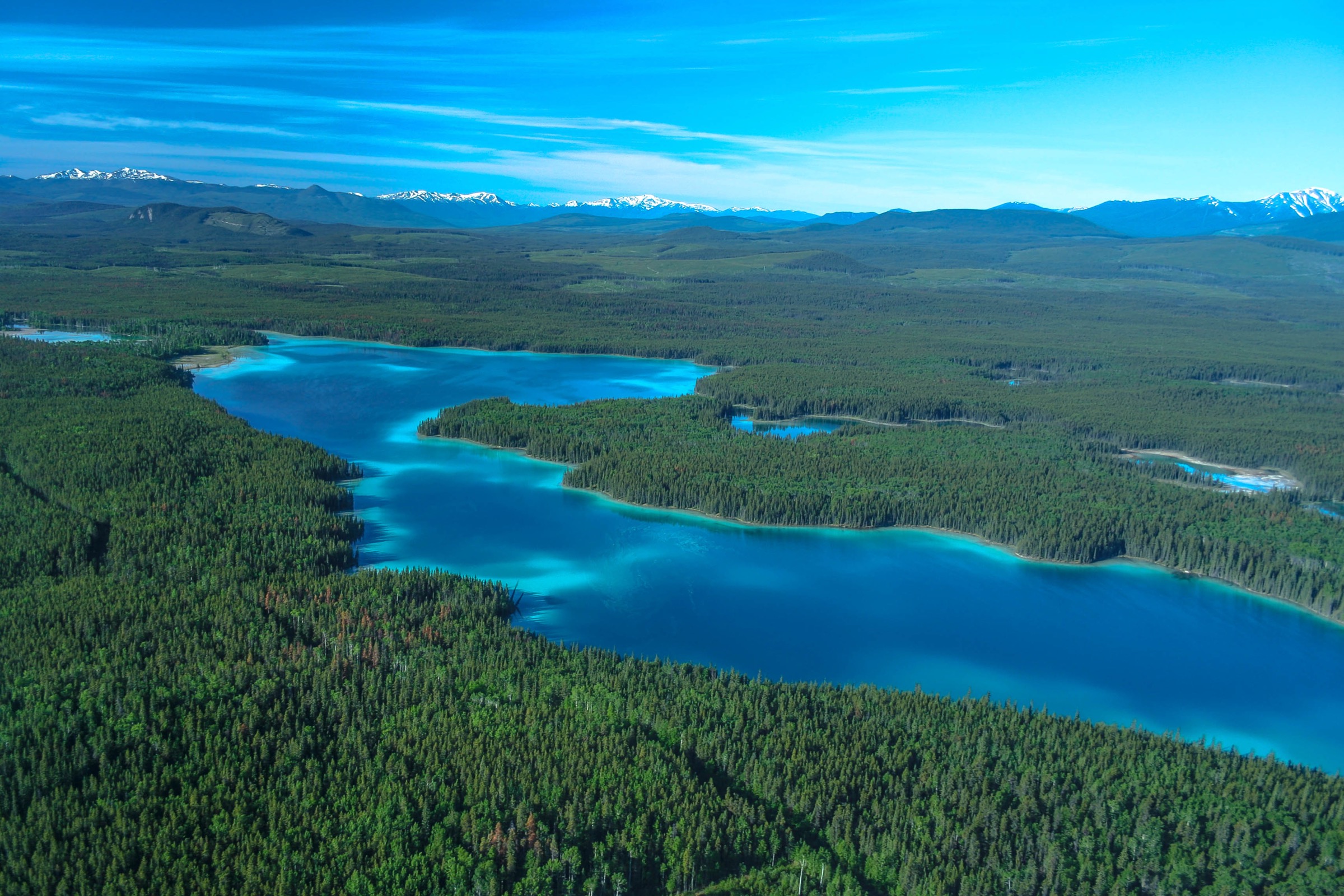
The Cassiar Mountains form the northernmost subdivision of British Columbia’s Interior Mountains, extending roughly 440 km from the Yukon border south-east to the confluence of the Finlay and Fox rivers in north-central BC. The range is bounded by the Liard River to the north, the Rocky Mountain Trench to the east, the Finlay River basin to the south, and the Stikine Plateau to the west. Major subranges include the Stikine Ranges, Kechika Ranges, Sifton Ranges and Horseranch Range, together with the Dease Plateau. Thudaka Peak in the southern Stikine Ranges is the highest summit at approximately 2,748 m. The general landscape is one of moderately rugged, glacially rounded, flat-topped peaks; alpine tundra; broad subarctic plateaus; spruce-willow-birch and boreal white and black spruce forest; cold lakes; and wide unbridged rivers.
The only road access into the heart of the range is provided by the Stewart-Cassiar Highway (Highway 37), which threads the western flank from Meziadin Junction north past Iskut, Tatogga, Dease Lake, Jade City and Boya Lake to the Alaska Highway. From this corridor a small number of secondary roads — most importantly the Ealue Lake Road / BC Rail grade towards Spatsizi Plateau Wilderness Provincial Park, the Telegraph Creek Road towards the Grand Canyon of the Stikine, and short access tracks to Boya Lake and Kinaskan Lake provincial parks — give the only road touchpoints with the interior. The principal protected areas of interior-side character are Spatsizi Plateau Wilderness Provincial Park, Mount Edziza Provincial Park, Stikine River Provincial Park, Tatlatui Provincial Park and Ta Ch’ila / Boya Lake Provincial Park.
The practical hiking season is short. BC Parks states that generally suitable backcountry travel weather in Mount Edziza Park occurs only between 1 July and 15 September, with snow and freezing rain possible on any day of the year; equivalent windows apply to Spatsizi and Tatlatui. Even within the season, trails are typically unmaintained, water crossings are unbridged, navigation is by cairn or by experience, magnetic volcanic rock can disturb compass readings in the Edziza area, and grizzly bear, black bear, moose, caribou and Stone’s sheep are present. Cellular service is absent for long stretches of Highway 37; the nearest medical and emergency services along the corridor are at Dease Lake and Stewart.
Selection rationale
The five hikes below were chosen to represent the interior and inland character of the Cassiar Mountains rather than the highway-coastal viewpoints of the Stewart-Cassiar corridor. Day-hikeable trail mileage reachable from a vehicle is sparse on the interior side, so the catalogue combines viewpoint trails inside Stikine River Provincial Park, plateau and creek day-hikes radiating from the fly-in base camp at Cold Fish Lake in Spatsizi, the Todagin alpine route above Tatogga, and a remote fly-in volcanic-landscape objective in the Edziza complex.
- Spatsizi Plateau Trail from Cold Fish Lake — the namesake plateau day-hike of one of Canada’s largest wilderness parks, reached from a floatplane base.
- Black Fox Creek Trail from Cold Fish Lake — the second BC Parks-recommended day-hike from the same Spatsizi base, sampling a creek-and-basin landscape.
- Tuya River Valley Viewpoint, Stikine River Provincial Park — the only signed, road-accessible interior viewpoint trail along the inland Cassiar corridor, overlooking the Grand Canyon of the Stikine.
- Todagin Mountain Trail — the best-documented road-accessed alpine day-hike on the corridor, climbing into Stone’s-sheep country above Tatogga.
- Eve Cone from Buckley Lake base, Mount Edziza — a remote fly-in objective on one of the most symmetrical young basaltic cinder cones in Canada.
A companion Stewart-Cassiar corridor article centred on Todagin Mountain, Cascade Falls, Natadesleen Lake, Boya Lake and Eve Cone; only Todagin and Eve Cone sit in interior alpine and volcanic terrain typical of the Cassiar Mountains and Tahltan Highland, so both are retained here. The Spatsizi-based pair and the Tuya River viewpoint replace the lower-elevation highway stops to better characterise the interior plateau landscape.
Summary table
| # | Hike | Country | Route type | Distance | Gain | Max elevation | Difficulty |
|---|---|---|---|---|---|---|---|
| 1 | Spatsizi Plateau Trail from Cold Fish Lake | Canada | Out-and-back | ~12.7 km | ~840 m | Not resolved | Hard |
| 2 | Black Fox Creek Trail from Cold Fish Lake | Canada | Out-and-back | Full-day, not resolved | Not resolved | Not resolved | Moderate–hard |
| 3 | Tuya River Valley Viewpoint | Canada | Short out-and-back | Sub-3 km estimated | Minor | ~900–1,000 m | Easy |
| 4 | Todagin Mountain Trail | Canada | Out-and-back | 6.6 km | 680 m | ~1,500–1,700 m | Hard |
| 5 | Eve Cone from Buckley Lake base | Canada | Remote fly-in out-and-back | ~11 km linear one-way | Not resolved | 1,702–1,740 m | Hard / remote |
1. Spatsizi Plateau Trail from Cold Fish Lake
Snapshot
Itinerary
The trail leaves Cold Fish Lake Campground on the north shore of Cold Fish Lake and climbs the wooded slope behind the cabins, steepening as it gains the open subalpine plateau above. Once on the plateau, the route opens into rolling alpine tundra typical of the southern Stikine Ranges and northern Skeena Mountains margin, with broad sightlines across the Spatsizi River basin, the Eaglenest Range and the Gladys Lake Ecological Reserve to the north-east.
BC Parks describes the route as a recommended day-hike from Cold Fish Lake, steep in sections, valuable for wildlife observation — Stone’s sheep, mountain caribou, mountain goat and grizzly bear — and panoramic views. There is no maintained tread on the plateau itself; hikers return by the ascent line.
Why it is essential
Spatsizi Plateau is the defining feature of the central interior Cassiar / Skeena interface and the namesake of one of the largest wilderness parks in Canada. The Spatsizi Plateau Trail is the only documented day-hike that takes a hiker from the Cold Fish Lake fly-in base directly into the high-tundra landscape that gives the park its character, and it is the closest the region offers to a representative alpine-tundra day route.
Equipment
- Mountain hiking equipment: sturdy boots, trekking poles, full rain shell, warm layer, hat and gloves.
- Bear spray and bear-aware food storage.
- Topographic map (NTS 104H/12 or 104H/13) with compass and GPS backup; cairns are scarce on the unmaintained plateau.
- Satellite communicator strongly recommended; no cellular coverage anywhere in the park.
- Insect protection — mosquito and blackfly are heavy in early summer.
Hazards and notes
- BC Parks: none of the park’s trails are frequently travelled or maintained; the route is suitable only for experienced, fit, properly equipped backcountry hikers.
- The trail is steep in sections; the plateau is exposed to fast-changing weather, including snow in any month.
- Camping, hunting, fishing, fires and collecting are forbidden inside the adjacent Gladys Lake Ecological Reserve.
- Cold Fish Lake camp facilities (cabins, cookhouse) are first-come-first-served and unattended.
- Floatplane access only; the BC Rail grade beyond 30 km is closed by washout. Confirm flight schedules with operators in advance.
- Grizzly habitat throughout; travel in a group where possible and carry bear spray.
GPX / KML links
| Source | URL | Format / access | Reuse status |
|---|---|---|---|
| BC Parks — Spatsizi Wilderness Park hiking | bcparks.ca | Official route description; no GPX | BC Parks website terms not evaluated; reference only |
| BC Parks — Spatsizi Plateau Park map (PDF) | nrs.objectstore.gov.bc.ca | Official PDF map | Government of BC terms not evaluated; reference only |
| AllTrails — Spatsizi Plateau Trail | alltrails.com | User-contributed map | AllTrails terms apply; reference only |
| TrailPeak — Spatsizi Plateau Trail | trailpeak.com | User-contributed map | TrailPeak terms apply; reference only |
External links
| Source | URL |
|---|---|
| BC Parks — Spatsizi Plateau Wilderness Park | bcparks.ca |
| BC Parks — Spatsizi Plateau Wilderness Park hiking | bcparks.ca |
| Wikipedia — Spatsizi Plateau Wilderness Provincial Park | en.wikipedia.org |
| PeakVisor — Spatsizi Plateau Wilderness Provincial Park | peakvisor.com |
2. Black Fox Creek Trail from Cold Fish Lake
Snapshot
Itinerary
The Black Fox Creek Trail leaves Cold Fish Lake Campground and climbs moderately along Black Fox Creek into the upland basin between the campground and Black Fox Lake. BC Parks describes a moderately steep route taking a full day depending on fitness, with sections that can be wet or muddy after rain. The upper basin offers open subalpine and alpine views typical of the central plateau, and hikers return by the same line; no loop is documented.
Why it is essential
Together with the Spatsizi Plateau Trail, Black Fox Creek is one of only two day-hikes BC Parks specifically recommends from the Cold Fish Lake base. It complements the plateau route by sampling a representative creek-and-basin landscape, and it is the second-most-cited interior Cassiar day-hike in the published BC Parks inventory.
Equipment
- Mountain hiking equipment with waterproof boots; the trail includes wet and muddy sections after rain.
- Bear spray, bear-aware food storage, satellite communicator.
- Topographic map and GPS; trail markers are sparse and game trails can confuse the route.
- Insect protection, warm layer and rain shell.
Hazards and notes
- Trail is unmaintained and lightly travelled; route-finding skill required.
- Sudden weather changes, with snow possible in any month.
- Grizzly bear country; carry bear spray and travel in a group where possible.
- Floatplane access only; confirm pickup window with operator before departure.
- No cellular coverage; satellite communication is the only reliable contact option.
GPX / KML links
| Source | URL | Format / access | Reuse status |
|---|---|---|---|
| BC Parks — Spatsizi Wilderness Park hiking | bcparks.ca | Official route description; no GPX | BC Parks website terms not evaluated; reference only |
| BC Parks — Spatsizi Plateau Park map (PDF) | nrs.objectstore.gov.bc.ca | Official PDF map | Government of BC terms not evaluated; reference only |
External links
| Source | URL |
|---|---|
| BC Parks — Spatsizi Plateau Wilderness Park | bcparks.ca |
| BC Parks — Spatsizi Plateau Wilderness Park hiking | bcparks.ca |
| Wikipedia — Spatsizi Plateau Wilderness Provincial Park | en.wikipedia.org |
3. Tuya River Valley Viewpoint, Stikine River Provincial Park
Snapshot
Itinerary
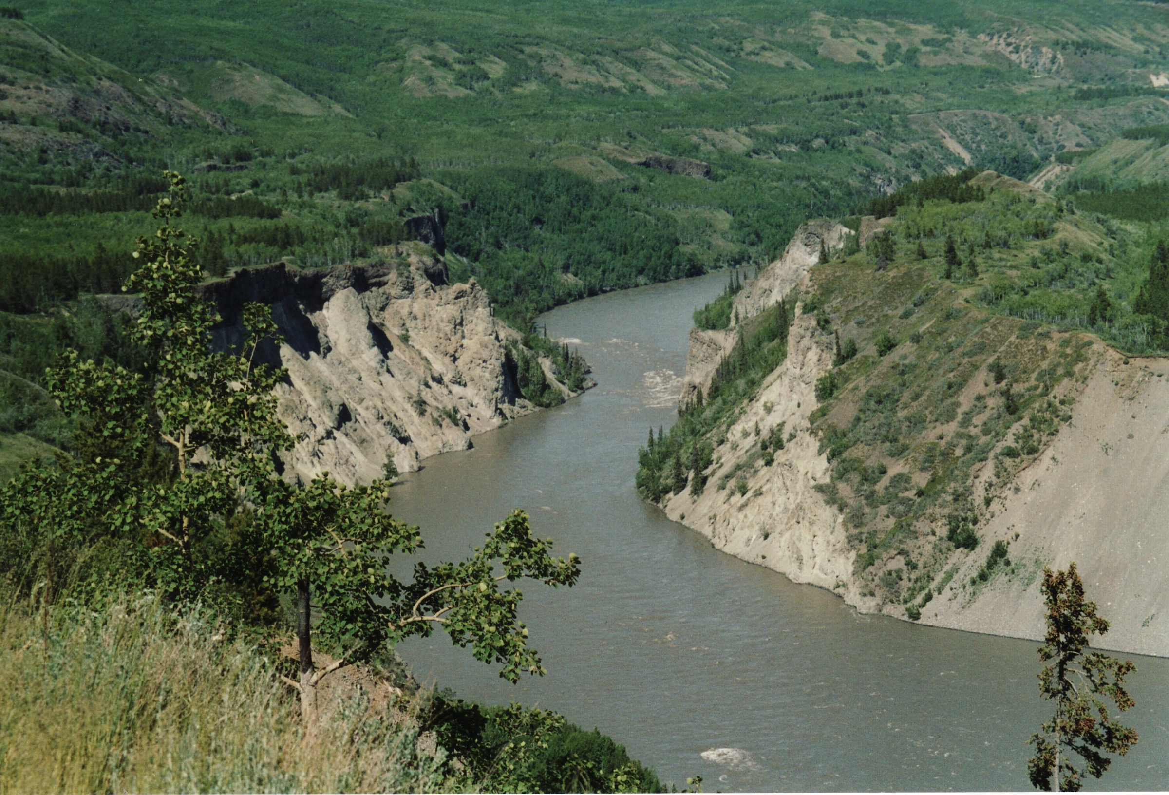
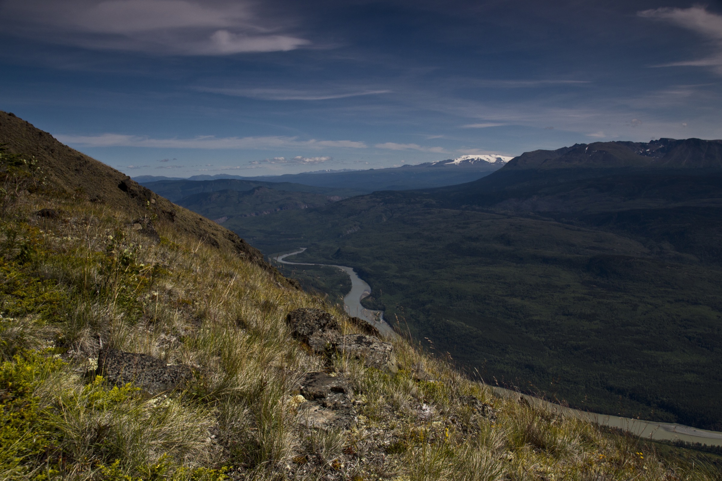
The trail begins at a signposted pullout on the north side of Telegraph Creek Road inside Stikine River Provincial Park, roughly 60 km west of Dease Lake. From the pullout a short, well-defined path leads through subalpine spruce and willow to an open rim viewpoint overlooking the Tuya River Valley and, beyond it, the western reaches of the Grand Canyon of the Stikine.
BC Parks emphasises that sharp drop-offs border the canyon rim throughout the park and that visitors must obey posted signs and stay on the designated trail to protect vegetation and avoid the unstable broken-rock edges.
Why it is essential
This is the only signed, road-accessible interior viewpoint trail along the inland Cassiar corridor. It provides a representative, very-low-commitment introduction to the Grand Canyon of the Stikine landscape — a 72 km, up-to-300 m deep canyon eroded into Tanzilla Plateau and Klastline Plateau sediments and volcanics — without requiring the canyon descent, which is reserved for experienced whitewater expeditions.
Equipment
- Standard hiking equipment with sturdy footwear; rim terrain is loose and uneven.
- Bear spray; the area is grizzly habitat.
- No water source on the trail; carry water.
- Sun protection and wind shell on the exposed plateau rim.
Hazards and notes
- BC Parks: sharp drop-offs border the entire Grand Canyon, broken rock is prevalent, and approaching the rim is extremely dangerous.
- The Telegraph Creek Road is unpaved, narrow, with steep grades and limited turnouts; inappropriate for large RVs and trailers below the Tuya River descent.
- Dease Lake is the closest fuel and emergency service point (approx. 60 km east).
- No camping at the trailhead; designated Forest Service campsites lie further west toward Glenora.
- Grizzly bear habitat throughout the canyon corridor.
GPX / KML links
| Source | URL | Format / access | Reuse status |
|---|---|---|---|
| BC Parks — Stikine River Park | bcparks.ca | Official park page; no GPX | BC Parks website terms not evaluated; reference only |
External links
| Source | URL |
|---|---|
| BC Parks — Stikine River Park | bcparks.ca |
| Wikipedia — Grand Canyon of the Stikine | en.wikipedia.org |
| Wikipedia — Tanzilla Plateau | en.wikipedia.org |
| Travel British Columbia — Stewart-Cassiar Highway 37 | travel-british-columbia.com |
4. Todagin Mountain Trail
Snapshot
Itinerary
From the unmarked pullout south of Tatogga Lake Resort, the trail crosses Highway 37 and ascends the west face of Todagin Mountain. BC Parks describes an unmaintained but generally well-defined trail climbing through mixed spruce-aspen forest, then subalpine fir, then subalpine meadow and open tundra. A creek crossing precedes a continuous steep section.
The upper subalpine bench opens to extensive views of Kinaskan Lake and Eddontenajon Lake to the west and the Klastline Plateau and Mount Edziza beyond. Continuation across the Todagin plateau toward Todagin South Slope Park proper requires stronger navigation and lies outside the basic day-hike objective.
Why it is essential
Todagin is the best-documented road-accessed alpine day-hike on the Cassiar corridor and the most direct way for a non-flying visitor to reach the subalpine zone of the western Stikine Plateau / Cassiar transition. The slope supports one of the densest populations of Stone’s sheep in British Columbia.
Equipment
- Mountain hiking equipment: sturdy boots, trekking poles, warm layer and rain shell.
- Bear spray and navigation backup; BC Parks notes the trailhead is unmarked and the route is unmaintained.
- 2 L water; the upper bench has no reliable water source.
- Topographic map and GPS for the open plateau above the bench.
Hazards and notes
- BC Parks: the trail is unmaintained, has deadfall and is continuously steep after the creek crossing.
- The trailhead is unmarked from the highway; expect to look for it.
- The BC Parks route lies outside Todagin South Slope Provincial Park itself; the open plateau crossing is more committing than the basic day-hike.
- Grizzly bear, black bear and Stone’s sheep present; the slope is also a working guide-outfitter area in season.
- No cellular service; Dease Lake and Stewart are the nearest emergency points.
GPX / KML links
| Source | URL | Format / access | Reuse status |
|---|---|---|---|
| BC Parks — Todagin South Slope Park hiking | bcparks.ca | Official route description; no GPX | BC Parks website terms not evaluated; reference only |
| AllTrails — Todagin Mountain Trail | alltrails.com | User-contributed map | AllTrails terms apply; reference only |
External links
| Source | URL |
|---|---|
| BC Parks — Todagin South Slope Park hiking | bcparks.ca |
| AllTrails — Todagin Mountain Trail | alltrails.com |
| Travel British Columbia — Stewart-Cassiar Highway 37 | travel-british-columbia.com |
5. Eve Cone from Buckley Lake base, Mount Edziza
Snapshot
Itinerary
From a remote base at Buckley Lake, the Buckley Lake to Mowdade Lake route runs south along Buckley Creek and gradually onto the northern end of the Big Raven Plateau, where Eve Cone, Sidas Cone and the broader Snowshoe Lava Field come into view. BC Parks specifies that climbers of Eve Cone must use only the main designated route on the south-eastern flank, which leads to a small bench on the north-eastern side and provides access to the crater rim.
The cone is one of the youngest and most symmetrical basaltic cinder cones in Canada, rising 172 m above the plateau. Hikers descend by the same designated line; off-route travel rapidly scars the loose surface.
Why it is essential
The Mount Edziza volcanic complex is the dominant landscape feature of the western Cassiar / Tahltan Highland and the only Holocene volcanic field in the region. Eve Cone is its single most photographed and most distinctive surface feature, and the only one to which BC Parks has designated a maintained access route. Although not road-accessible, the cone belongs in the catalogue because no honest inventory of essential interior Cassiar / Stikine Plateau hiking landscapes can omit it.
Equipment
- Full remote mountain hiking equipment: sturdy boots suitable for loose scoria and lava clinker, warm layers, hat, gloves, waterproof shell.
- Satellite communicator, full topographic map set and GPS; magnetic anomalies in volcanic rock can make compass bearings unreliable on the plateau.
- Bear-proof food storage and bear spray.
- Confirmed floatplane pickup window with operator before departure.
- Stove, fuel and rations for the full base-camp stay; no resupply on the plateau.
Hazards and notes
- BC Parks: Mount Edziza is an isolated wilderness with no vehicle access, unmaintained overland access trails, lingering snow, possible freezing rain on any day of the year, sudden creek rises and high winds.
- Floatplane access only; aircraft landings in restricted zones require written authorisation from the BC Parks Stikine Senior Park Ranger, and only Alpine Lakes Air and BC Yukon Air are currently authorised.
- BC Parks asks hikers to stay strictly on the designated route on Eve Cone’s south-eastern flank to prevent surface scarring; cones are fragile.
- The full Klastline River Trail or Buckley Lake to Mowdade Lake traverse is a 70 km, minimum-seven-day backpacking expedition — distinct from the day objective described here.
- Magnetic volcanic rock can disturb compass readings; redundant GPS navigation is essential.
- Grizzly and black bear habitat; carry bear spray and store food in approved containers.
GPX / KML links
| Source | URL | Format / access | Reuse status |
|---|---|---|---|
| BC Parks — Mount Edziza Park hiking | bcparks.ca | Official route / access notes; no GPX | BC Parks website terms not evaluated; reference only |
| BC Parks — Mount Edziza prohibited aircraft take-off and landing zone (KMZ) | nrs.objectstore.gov.bc.ca | KMZ regulatory layer | Government of BC terms not evaluated; not a hiking route |
External links
| Source | URL |
|---|---|
| BC Parks — Mount Edziza Park | bcparks.ca |
| BC Parks — Mount Edziza Park hiking | bcparks.ca |
| Wikipedia — Eve Cone | en.wikipedia.org |
| Wikipedia — Mount Edziza volcanic complex | en.wikipedia.org |
External links
| Source | URL |
|---|---|
| BC Parks — Spatsizi Plateau Wilderness Park | bcparks.ca |
| BC Parks — Spatsizi Plateau Park map (PDF) | nrs.objectstore.gov.bc.ca |
| BC Parks — Mount Edziza Park | bcparks.ca |
| BC Parks — Mount Edziza Park hiking | bcparks.ca |
| BC Parks — Stikine River Park | bcparks.ca |
| BC Parks — Todagin South Slope Park hiking | bcparks.ca |
| BC Parks — Tatlatui Park | bcparks.ca |
| BC Parks — Ta Ch’ila / Boya Lake Park | bcparks.ca |
| Wikipedia — Cassiar Mountains | en.wikipedia.org |
| Wikipedia — Stikine Ranges | en.wikipedia.org |
| Wikipedia — Mount Edziza | en.wikipedia.org |
| Wikipedia — Grand Canyon of the Stikine | en.wikipedia.org |
| PeakVisor — Cassiar Mountains | peakvisor.com |
| PeakVisor — Mount Edziza Provincial Park | peakvisor.com |
| Travel British Columbia — Stewart-Cassiar Highway 37 | travel-british-columbia.com |
| Stewart-Cassiar Highway tourism portal | stewartcassiarhighway.com |