Regional overview
Haida Gwaii — the archipelago formerly known as the Queen Charlotte Islands — sits roughly 100 km off the north coast of British Columbia, separated from the mainland by the Hecate Strait. The Queen Charlotte Mountains form the spine of the islands’ western edge, running from the Naikoon plateau on northeastern Graham Island down through Moresby Island and the smaller southern islands of Gwaii Haanas. Summits are modest by Cordilleran standards — the highest, Mount Moresby on Moresby Island, reaches only 1,164 m — but the maritime climate makes them feel much wilder. Annual rainfall on the windward (west) coast exceeds 4 m, the treeline sits low because of wind and bog soils, and weather can shift from calm to gale within hours. Vegetation grades from dense Sitka spruce, western hemlock and red cedar rainforest on the lower slopes, through stunted yellow-cedar and mountain hemlock krummholz, to small alpine bowls of heather, blueberry and exposed slate.
The islands are the homeland of the Haida Nation, who have lived here for millennia. The legal and political context is distinctive: Gwaii Haanas at the southern end is co-managed by the Council of the Haida Nation and Parks Canada (and Fisheries and Oceans Canada for the marine portion), and Naikoon Provincial Park at the northern end is managed by BC Parks. Many landmarks have had their Haida names officially restored — Tow Hill became Taaw Tldáaw in 2022, Queen Charlotte was renamed Daajing Giids in 2022, and Skidegate is known as HlG̱aagilda. Visitors are expected to behave respectfully around cultural sites; some areas in Gwaii Haanas require a Haida Gwaii Watchmen orientation before access.
Practical access is by BC Ferries from Prince Rupert to Skidegate (about a 7-hour crossing, two to five round trips weekly depending on season) or by air to Sandspit (YZP) and Masset (ZMT). On-island travel runs on Highway 16, which connects Skidegate and Daajing Giids in the south with Tlell, Port Clements and Masset in the north; Moresby Island is reached by the short Kwuna ferry from Skidegate to Alliford Bay. Logging-road access into the mountains is rough and frequently active; high-clearance vehicles are recommended for the Honna and Moresby road systems.
The catalogue of established alpine day-hikes is unusually short. Most “mountain” walking is concentrated in three places: the cluster of slate peaks west of Daajing Giids (Sleeping Beauty / Tarundl, Slatechuck), a single demanding route up Mount Moresby, and a series of bog- and beach-oriented walks within Naikoon Provincial Park. Safety considerations are unusually significant: weather exposure, sea-fog navigation problems, fixed-rope sections that degrade in the wet, sparse cellular coverage off the highway, no organised mountain rescue, and a black bear population (Ursus americanus carlottae) noted by biologists for unusually large body size.
Selection rationale
Only the Sleeping Beauty (Tarundl) and Mount Moresby routes are genuinely alpine day-hikes. Slatechuck Mountain is a credible extension to Sleeping Beauty but uses the same trailhead system and is included as part of the Sleeping Beauty entry. To fill the catalogue to five, the entry adds Taaw Tldáaw / Tow Hill (very short but iconic and the only formed summit walk in Naikoon), Pesuta Shipwreck on the East Beach Trail (the standard Naikoon coastal walk, marked Candidate only because it is coastal-forest rather than mountain), and the Spirit Lake Trail at Skidegate (low-elevation but the most-used community trail; also Candidate only). Cape Fife is a multi-day backpack and is not included. The inventory is honestly thin: Haida Gwaii is not a day-hike destination in the conventional sense.
Summary table
| # | Hike | Sub-region | Route type | Distance | Gain | Max elevation | Difficulty |
|---|---|---|---|---|---|---|---|
| 1 | Sleeping Beauty / Tarundl (Mount Raymond) | Graham Island — Daajing Giids | Out-and-back | ~7–8 km | ~640–840 m | ~1,013 m | Hard |
| 2 | Mount Moresby | Moresby Island | Out-and-back | ~13.6 km | ~1,050 m | 1,164 m | Very hard |
| 3 | Taaw Tldáaw (Tow Hill) & Blow Hole | Graham Island — Naikoon PP | Loop | ~2.5 km | ~100 m | 125 m | Easy |
| 4 | Pesuta Shipwreck (East Beach) — Candidate | Graham Island — Naikoon PP | Out-and-back | ~12 km | negligible | ~10 m | Moderate |
| 5 | Spirit Lake Trail — Candidate | Graham Island — Skidegate | Loop network | ~4.3 km | minimal | ~30 m | Easy |
1. Sleeping Beauty / Tarundl (Mount Raymond)
Snapshot
Itinerary
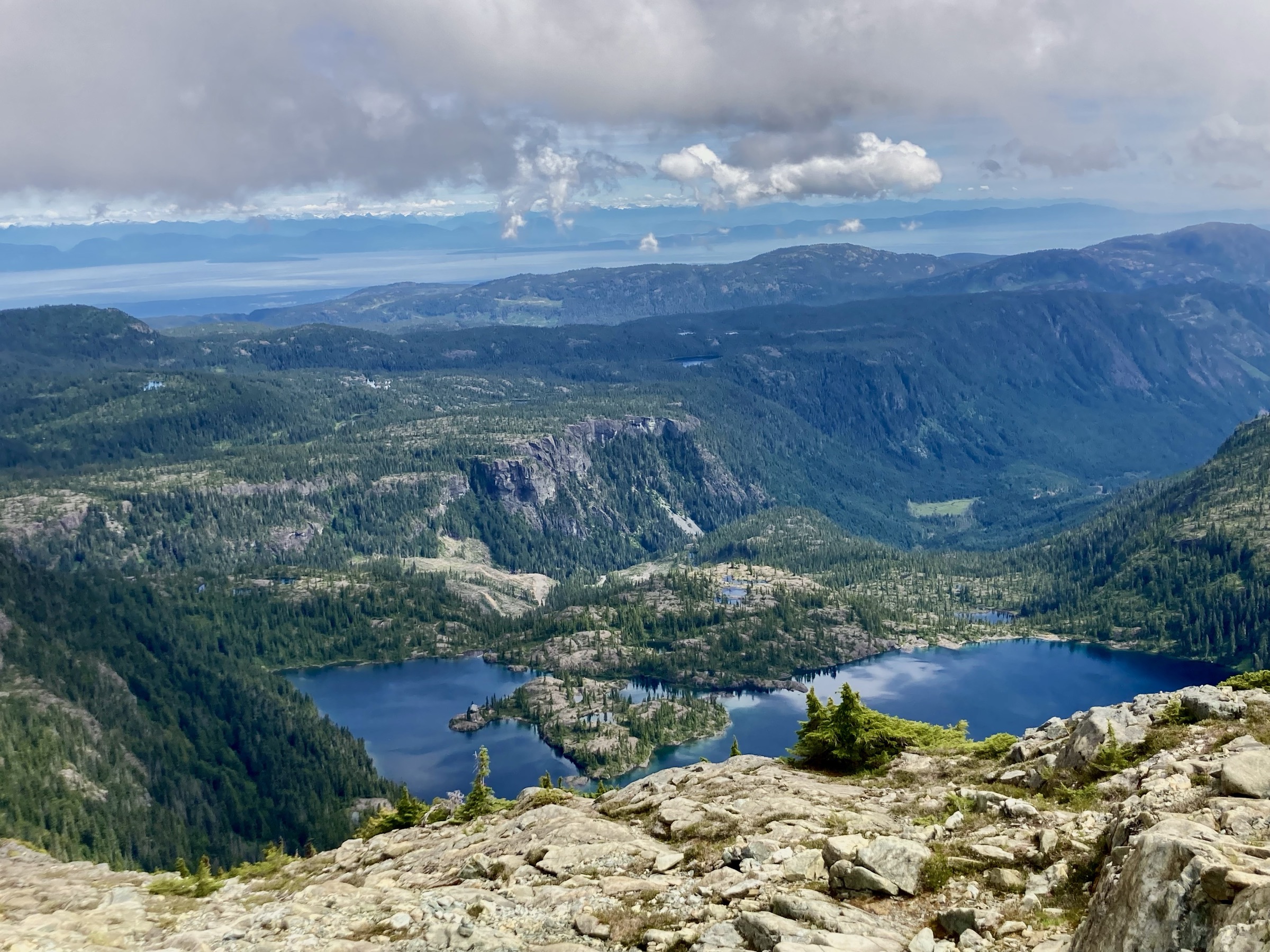
The Tarundl Trail leaves Daajing Giids west on Oceanview Drive past the cemetery and Haydn Turner campground, then turns right onto the Honna Forest Service Road. After roughly 3.8 km, a marked right turn climbs past the Kagan Bay Recreation Site, and a further 1.3 km of spur road reaches the signed Sleeping Beauty cut-off. The trailhead proper sits about 3.5 km past the Slatechuck trailhead at a small clearing capable of holding several vehicles. The lower trail crosses a footbridge over Tarundl Creek and follows a short section of reclaimed road before turning into mature western hemlock and red cedar rainforest. The climb is steep almost immediately, gaining roughly 550 m in 2.25 km through a series of muddy switchbacks, rooted steps, and six fixed-rope sections that ease passage over slick slabs. The forest opens onto a hanging bowl with a small tarn and stunted mountain hemlock. From the bowl, the route scrambles up the south ridge of Mount Raymond on heather and broken slate to the 1,013 m summit, where the panorama on a clear day takes in Bearskin Bay, Skidegate Inlet, Yakoun Lake, and the inland peaks toward Rennell Sound. Parties with energy can continue south along a connector ridge across a minor bump and onto Slatechuck Mountain, adding roughly 2 km return and around 200 m of additional gain.
The mountain is known in Haida as Kuu Jad TlldaGaaw K’yuu, a name now used on local signage and visitor-centre materials.
Why it is essential
The Tarundl route is the only roadhead-to-alpine day-hike on Graham Island. The combination of dense lower rainforest, a hanging tarn, and a true 360-degree summit with views across two oceans (Hecate Strait to the east, the open Pacific over Rennell Sound to the west) makes it the regional standard for an alpine day in the islands.
Equipment
- Waterproof boots and gaiters.
- Full rain shell and an insulating layer — weather changes fast at 1,000 m.
- Gloves for the rope sections.
- Headlamp.
- Navigation: offline map and GPS — cell coverage is intermittent.
- Bear spray.
- Food and a minimum 2 L of water; no reliable water above the tarn.
- Trekking poles useful for the descent.
Hazards and notes
- Steep mud and slick roots low down; six rope sections that should be tested before weight is committed.
- Exposed slate and small cornices near the summit into early July.
- Sudden fog can obscure the descent route off the summit ridge.
- The access road is active logging country — yield to industrial traffic and carry a spare tyre.
- Black bears are present along the lower trail and in the bowl.
- No formal trail maintenance schedule; consult the Daajing Giids Visitor Centre for current conditions.
GPX / KML links
| Source | URL | Format / access | Reuse status |
|---|---|---|---|
| Sonny Bou trip report (sleepingbeauty.zip) | sonnybou.ca | GPX (zipped) | Personal trip-report; no explicit licence — reference only |
| AllTrails community trace | alltrails.com | GPX (account required) | AllTrails terms — not redistributable |
External links
- Hike Haida Gwaii — Sleeping Beauty Trail
- Daajing Giids Visitor Centre — Sleeping Beauty Trail
- Sonny Bou — Mount Raymond and Slatechuck
- Bivouac.com — Sleeping Beauty and Mount Raymond
2. Mount Moresby
Snapshot
Itinerary
The approach begins at Alliford Bay (vehicle ferry from Skidegate). Drive south on Alliford Bay Mainline for about 12 km to a three-way junction, bear left onto South Bay Mainline for a further 6.2 km, then turn right onto Moresby Road and continue roughly 11 km to an unsigned junction near Moresby Camp. The final spur to the trailhead is deactivated, so most parties park some distance short and walk the last 1–1.5 km. From the trail’s start the path climbs steeply through old-growth western hemlock and yellow-cedar adjacent to a creek, then hits two fixed-rope sections used to surmount steep mossy slabs. Above these the angle eases briefly before a long, exposed grassy slope leads to treeline. The upper mountain is rocky alpine: heather benches give way to broken talus and a final scramble up a defined ridge to the rounded summit at 1,164 m, the highest point on Haida Gwaii. On a clear day the view encompasses Cumshewa Inlet, Skidegate Inlet, Sandspit and — across Hecate Strait — the mainland Coast Mountains. The descent reverses the route; both rope sections require slow, controlled lowering with a pack.
Why it is essential
Mount Moresby is the high point of the entire archipelago and the only day-feasible route to genuine alpine on Moresby Island. The combination of long approach, heavily forested base, fixed-rope crux, and clear summit makes it the most demanding sanctioned day-hike in the region.
Equipment
- Sturdy waterproof boots.
- Gloves; helmet optional but sensible for the rope sections in wet conditions.
- Full rain shell and insulating layer.
- Headlamp — parties often finish in the dark.
- Navigation tools and a downloaded GPX; no signage above treeline.
- Bear spray.
- 2.5–3 L water, food, and a basic first-aid kit.
- Two-way satellite messenger strongly recommended.
Hazards and notes
- Active logging on the access roads; check Mosaic Forest Management or BC Timber Sales schedules.
- Fixed ropes are maintained informally and should not be loaded without testing.
- Snow can persist in the upper bowl into July and reappears by late September.
- The descent is the dangerous half: parties have been benighted, and a small slip on the upper slabs can have serious consequences.
- No signage and a faint trail above treeline — a GPX track is essential for safe descent in fog.
GPX / KML links
| Source | URL | Format / access | Reuse status |
|---|---|---|---|
| Sonny Bou trip report (moresby.zip) | sonnybou.ca | GPX (zipped) | Personal trip-report; no explicit licence — reference only |
| Trailforks community track | trailforks.com | GPX (account required) | Trailforks terms — not redistributable |
External links
- Wikipedia — Mount Moresby
- Sonny Bou — Mount Moresby trip report
- Haida Gwaii Observer — hikers summit Mount Moresby
- Trailforks — Mt Moresby Trail
3. Taaw Tldáaw (Tow Hill) and Blow Hole
Snapshot
Itinerary
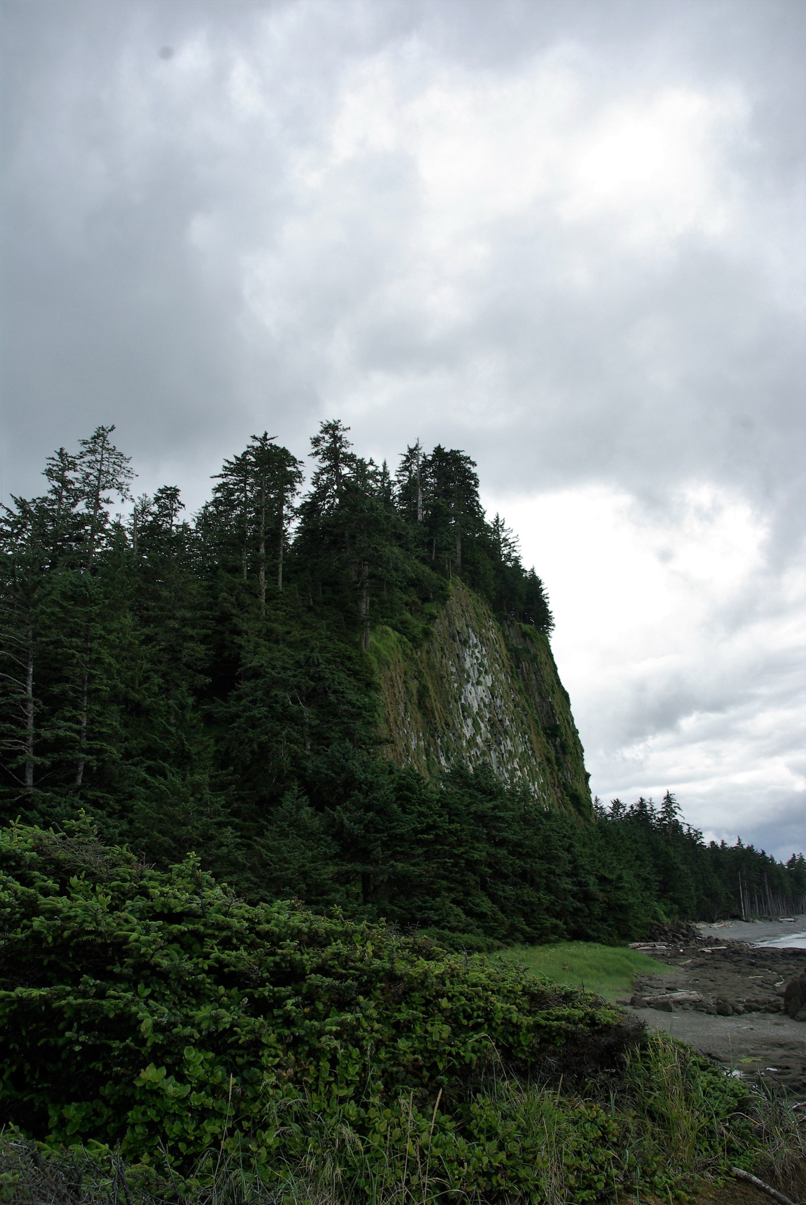
The trail starts at the BC Parks day-use area beside the Hiellen River. A boardwalk leads roughly 500 m through Sitka spruce and red cedar to a junction. The right-hand branch drops to the foreshore and the Blow Hole, a cavity in the columnar basalt at the base of the volcanic plug that produces a spray on a flooding tide with surf. The left-hand branch climbs by a series of wooden staircases and elevated boardwalk to two summit viewpoints fitted with mounted binoculars and interpretive panels. On a clear day, the upper viewpoint reveals North Beach, Rose Spit and — across Dixon Entrance — the southern coast of Alaska. The boardwalk loops back through old-growth forest to the trailhead.
The hill is geologically unusual: an eroded volcanic plug of columnar-jointed basalt that solidified roughly two million years ago. Its restored Haida name Taaw Tldáaw was made official in 2022; “Tow” derives from a Haida word meaning “place of food,” and the site is culturally significant.
Why it is essential
At only 125 m, Taaw Tldáaw is not alpine, but it is the only formed summit trail in Naikoon and one of very few maintained mountain walks on Haida Gwaii. The combination of basalt geology, sea-views across the Dixon Entrance to Alaska, and accessible boardwalk infrastructure makes it the most-completed mountain walk on the islands.
Equipment
- Waterproof footwear — boards are slippery when wet.
- Rain shell.
- Binoculars optional (mounted ones provided at the upper viewpoint).
- Insect repellent in summer.
Hazards and notes
- The unrailed sections of the upper boardwalk pass close to steep, brush-covered cliffs; BC Parks signage requires dogs on a leash for this reason.
- The Blow Hole spur should not be approached in heavy surf or on a fast incoming tide.
- Winter conditions can ice the boardwalk; the site has no winter maintenance.
- Black bears use the river corridor, particularly during salmon runs.
GPX / KML links
| Source | URL | Format / access | Reuse status |
|---|---|---|---|
| OpenStreetMap (query Tow Hill Trail) | openstreetmap.org | OSM data | ODbL — reusable with attribution |
| Trailforks community track | trailforks.com | GPX (account required) | Trailforks terms — reference only |
External links
4. Pesuta Shipwreck via East Beach
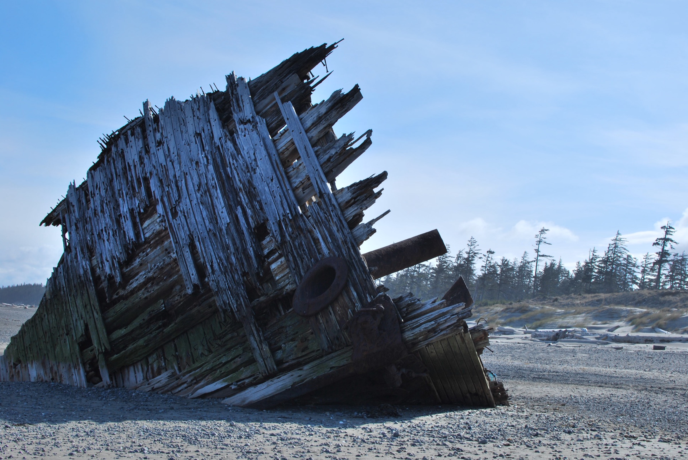
Snapshot
Itinerary
The trail leaves the Tlell River Picnic Area on Highway 16 and follows the south bank of the Tlell River through Sitka spruce and shore pine for about 2.5 km, on a mixture of forest path, wooden staircase and short boardwalks. The path then meets an old dirt access track that continues parallel to the river for a further 3.5 km, with the river widening into a tidal estuary. At the river mouth the route emerges onto open sand on the southern flank of East Beach; the rusted bow of the log barge Pesuta — wrecked here in a December 1928 gale — lies a short distance up the beach. From the trailhead the wreck is roughly 6 km one-way.
This walk is the southern end of the 89 km East Beach Trail, the multi-day route that runs north to Rose Spit and on to Tow Hill.
Why it is essential
This is the most-walked day route in Naikoon, the standard introduction to the East Beach coastline, and the only readily accessible section of the long East Beach traverse. Included as a candidate only because it is a coastal-forest and beach walk rather than a mountain hike; the regional inventory is too thin to omit it.
Equipment
- Waterproof boots or trail runners that can take saltwater.
- Gaiters for the dune section.
- Rain shell and wind layer.
- Tide table for the river mouth.
- Bear spray.
- Water (1–1.5 L).
- Insect repellent during summer.
Hazards and notes
- The crossings at the Tlell River mouth become impassable at high tide; plan around low or receding water.
- ATVs and 4×4 vehicles are permitted on the beach and can move fast — stay alert.
- The forest section is dim and root-laced; ankles need attention.
- No cell coverage beyond the highway.
- Drinking water is unsafe to take from the river.
GPX / KML links
| Source | URL | Format / access | Reuse status |
|---|---|---|---|
| AllTrails community track | alltrails.com | GPX (account required) | AllTrails terms — not redistributable |
| Trailforks community track | trailforks.com | GPX (account required) | Trailforks terms — not redistributable |
| Gaia GPS trailhead coordinates | gaiagps.com | Reference coords (53.5957°N, 131.9700°W) | Gaia terms — reference only |
External links
- BC Parks — Naikoon Park
- Happiest Outdoors — Pesuta Shipwreck Trail
- AllTrails — Pesuta Shipwreck Trail
- Atlas Obscura — Pesuta Shipwreck
5. Spirit Lake Trail (K’yuu Aanagung)
Snapshot
Itinerary
From the trailhead at the gravel parking lot — marked by a carved welcome figure attributed to Bill Bellis — the network branches into three signed routes. The shortest is a Forest Walk that loops through mossy old-growth Sitka spruce and western red cedar with interpretive panels on Haida traditional use, including Culturally Modified Trees where bark strips have been taken historically for weaving and toolmaking. The main Spirit Lake Loop circles the two small lakes on a 1–1.5 m wide gravel path, with wooden bridges over outlet creeks and picnic platforms at the lake edges. The Lake Connector Loop adds a longer circuit between the two basins. The trails intersect repeatedly and a complete circuit comes to about 4.3 km. The recently added K’yuu Aanagung Connector — Haida for “look out / around trail” — extends the network roughly 2 km westward as a point-to-point.
Why it is essential
Spirit Lake is the community trail of HlG̱aagilda Skidegate and is the closest formal interpretive walk to the ferry terminal. It is included as the regional baseline easy walk and as the only routinely accessible Haida-named forest network on the islands. A candidate only — it is not a mountain hike — but the regional inventory leaves it as the most defensible fifth selection.
Equipment
- Light hiking shoes.
- Waterproof shell in wet weather.
- Binoculars for waterfowl on the lakes.
- Mosquito repellent in early summer.
Hazards and notes
- Trail surfaces are well-built but slippery when wet, particularly on the bridge decks.
- Black bears are present in the surrounding forest.
- Cultural sites and CMTs along the route should not be approached, touched or photographed close-up out of respect for Haida protocol — interpretive signage indicates appropriate behaviour.
GPX / KML links
| Source | URL | Format / access | Reuse status |
|---|---|---|---|
| Trailforks community track | trailforks.com | GPX (account required) | Trailforks terms — not redistributable |
External links
- Hike Haida Gwaii — Spirit Lake Connector / K’yuu Aanagung
- eh Canada Travel — Spirit Lake Trail
- eh Canada Travel — K’yuu Aanagung Connector
- Ursula’s Weekly Wanders — Spirit Lake Trail
Missing data / follow-up work
- The inventory of true alpine day-hikes on Haida Gwaii is genuinely thin; only Sleeping Beauty / Tarundl and Mount Moresby are unambiguous mountain day-hikes from a road.
- No CC-licensed image of Sleeping Beauty / Mount Raymond / Slatechuck (Hike 1) was located. Commons coverage of the islands’ interior peaks is very sparse.
- No CC-licensed image of the Mount Moresby summit (Hike 2) was located.
- No CC-licensed image of the Spirit Lake Trail at Skidegate (Hike 5) was located on Wikimedia Commons or Flickr CC in this pass.
- No openly licensed official GPX is available for any of the five routes. An OSM-based extraction would be the most reusable option but coverage on the upper sections of Sleeping Beauty and Mount Moresby is incomplete.
- Sandspit’s local trails (Dover / Onward Point) are well under 5 km and not mountain — screened out. Dover Trail is the strongest community walk on Moresby Island if the catalogue is widened.
- Mosquito Mountain requires paddling Mosquito Lake to reach the trailhead — not a day-hike from a road in the usual sense.
- Anvil Trail at Tlell is a 5 km loop through riparian floodplain — excluded as not mountain.
- Cape Fife Loop (35 km) is correctly multi-day backcountry; excluded.
- Gwaii Haanas is boat / kayak access only; no road-accessible day-hikes within the park.
- Haida cultural context is summarised at a high level only; deeper place-name and protocol research with the Council of the Haida Nation and Haida Heritage Centre at Kay Llnagaay would strengthen revisions.
- Logging road access on Honna FSR and the Moresby Mainline is subject to active operations; conditions should be re-checked before publication and seasonally thereafter.
External links
| Source | URL |
|---|---|
| BC Parks — Naikoon Provincial Park | bcparks.ca |
| Parks Canada / Council of the Haida Nation — Gwaii Haanas | parks.canada.ca |
| Go Haida Gwaii | gohaidagwaii.ca |
| Daajing Giids Visitor Centre | daajinggiidsvisitorcentre.com |
| Hike Haida Gwaii | hikehaidagwaii.com |
| Sandspit, Haida Gwaii (community site) | sandspitbc.ca |
| BC Ferries — Prince Rupert / Skidegate | bcferries.com |
| Bivouac.com — Sleeping Beauty and Mount Raymond | bivouac.com |
| Sonny Bou trip reports | sonnybou.ca |
| Trailforks — Haida Gwaii region | trailforks.com |
| AllTrails — Naikoon Provincial Park | alltrails.com |
| Wikipedia — Mount Moresby | en.wikipedia.org |
| Wikipedia — Taaw Tldáaw | en.wikipedia.org |