Regional overview
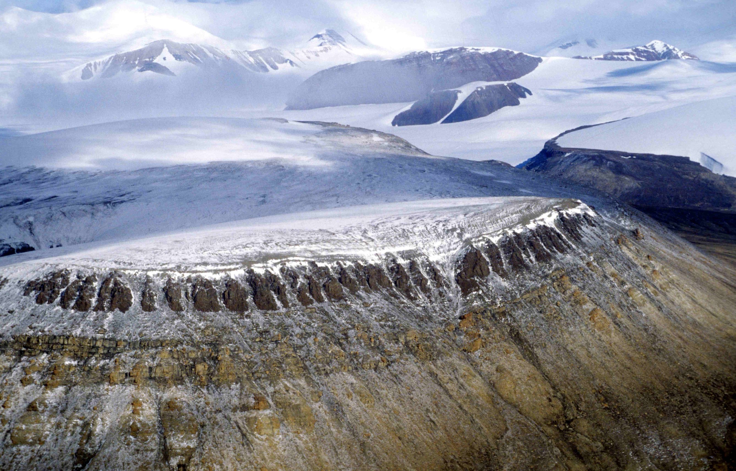
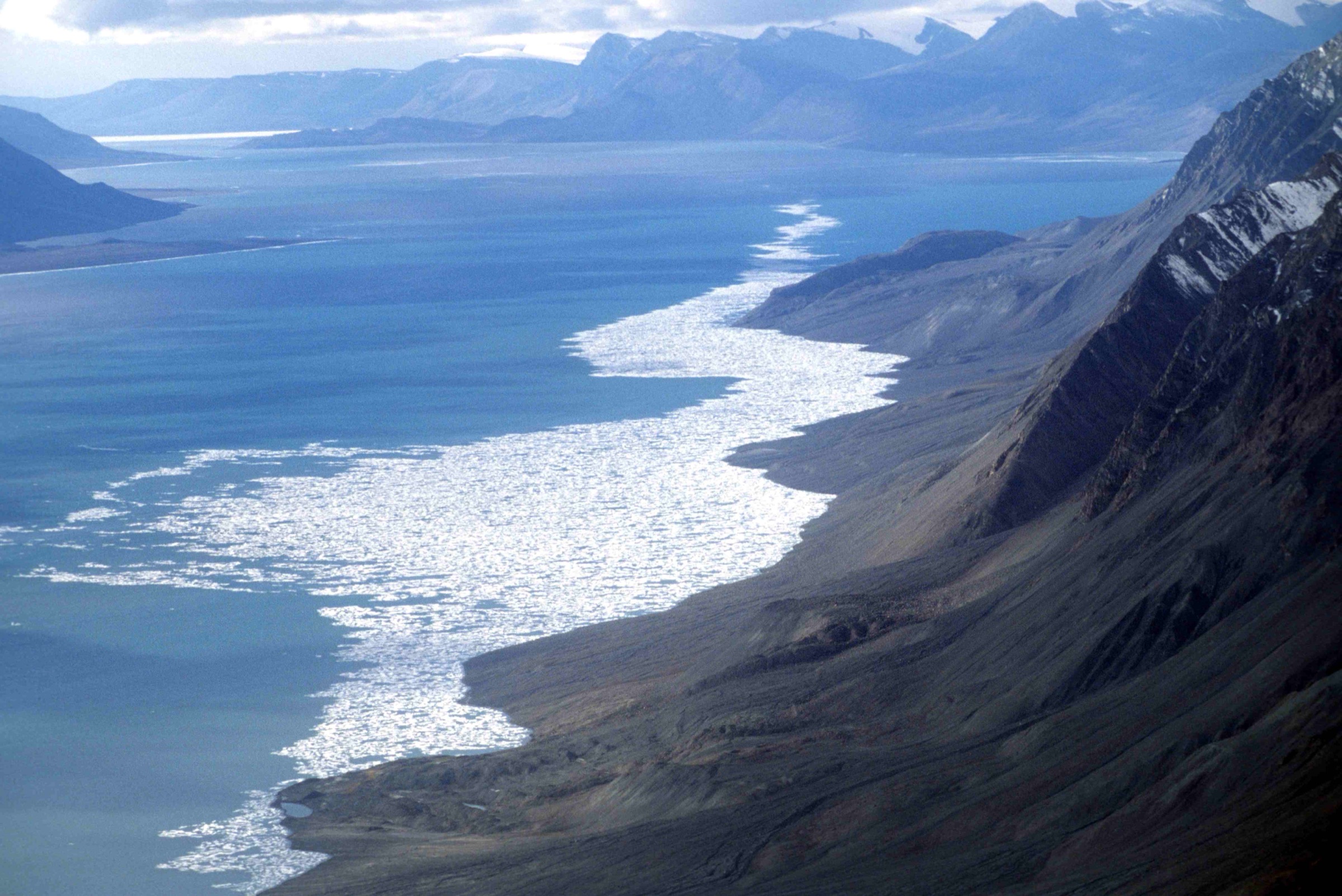
The Grant Land Mountains are the historic and informal name for the mountainous interior of Grant Land — the entire northern lobe of Ellesmere Island, named in honour of US President Ulysses S. Grant by the British Arctic Expedition under George Nares in 1875–76. In current usage the upland complex is subdivided into the formal British Empire Range (containing Barbeau Peak at 2,616 m — the highest summit in Nunavut and in eastern North America — together with Mount Whisler around 2,500 m and Mount Oxford at 2,210 m), the United States Range to the east (Mount Eugene 1,880 m), and the Challenger Mountains to the north. The Grant Ice Cap (high point about 1,437 m) and the Ad Astra Ice Cap (1,676 m, retreating) sit on the high ground around and between these named ranges. Roughly 36 % of Quttinirpaaq National Park is glaciated, with some ice masses approximately one kilometre thick.
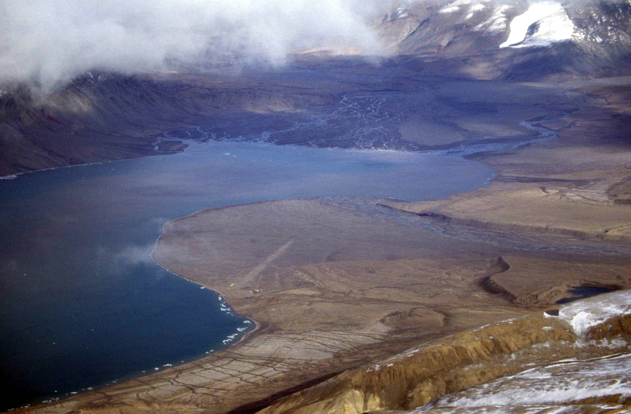
The southern gateway to the Grant Land Mountains complex is Tanquary Fiord, where three named rivers — the Air Force, the Macdonald and the Rollrock — converge at the fiord head. The Parks Canada warden station here was first built as the Operation Tanquary scientific base in 1963 under Geoffrey Hattersley-Smith and the Defence Research Board; the original Quonset hut and Jamesway tents are still in use. Tanquary is reached by chartered Twin Otter from Resolute Bay (CYRB) — typically operated by Kenn Borek Air with 8–9 passenger capacity, a 1,200 kg payload limit, and round-trip charter costs commonly quoted in the C$60,000–70,000 range per group leg, fuel-dependent. There is no road, no scheduled passenger service and no alternative access. Every visitor must register with Parks Canada and attend a mandatory in-person orientation before flying north, with daily excursion fees (CAD $16 in the 2024 schedule), camping permits (CAD $33.25/day) and Weatherhaven shelter rates (CAD $28–33.50) applying through the season.
Two formally published Parks Canada walking documents exist for this sector: the Kettle Lake Walking Tour brochure (a 5 km interpretive loop covering Pre-Dorset and Independence I archaeological sites along the Macdonald-valley delta) and the much longer Tanquary Fiord Hiking Guide (a 5.6 MB PDF covering area-overview walking from the warden station). These are the only formal trail documents anywhere in the 37,775 km² national park. Everything else in this article is the best inferable day-walk objective from the warden station, derived from the Tanquary Hiking Guide, the Wikipedia and Wikivoyage Tanquary entries, the American Alpine Journal expedition reports for the high range, and the published Ansgar Walk 1997 photographs.
The walks listed here run from the warden station up the lower river valleys that drain the Grant Land Mountains southwards. They are not climbs of named summits — the Grant Land high peaks are mountaineering objectives, almost entirely glaciated, with perhaps a few dozen total ascents in recorded history. They are walking days that approach the ice mass and give the visitor a fair sense of the range without committing to expedition-level travel.
Selection rationale
The five routes below sample the named walking objectives within day-trip distance of the Tanquary Fiord warden station. The Kettle Lake Walking Tour is included because it is the only formally published Parks Canada walking route in the entire park and the canonical introduction to the area. The Macdonald and Rollrock valley walk-ups follow the lower portions of two of the three named river systems that drain the Grant Land Mountains south into Tanquary, and they are walked outbound on day one by every multi-day backpacking party crossing the park. The Gull Glacier viewpoint walk visits the most distinctive single landscape feature visible from the warden station — a glacier toe immediately opposite the camp, locally nicknamed the “Hand of God.” The lower Air Force River valley walk-up is the longest of the five and approaches the toe of the Air Force Glacier, which descends from the Grant Ice Cap and is the standard mountaineering exit route from Barbeau Peak. Together the five walks span the area’s defining themes — the official interpretive walk, the three lower river valleys, and the closest glacier viewpoint within day-trip range of the camp.
Summary table
| # | Hike | Country | Route type | Distance | Gain | Max elevation | Difficulty |
|---|---|---|---|---|---|---|---|
| 1 | Kettle Lake Walking Tour (Muskox Way) | Canada | Loop | About 5 km | About 70 m | About 120–150 m | Easy |
| 2 | Macdonald River lower-valley walk | Canada | Out-and-back | About 12–18 km return | Minimal (valley floor) | About 200 m | Easy–moderate |
| 3 | Rollrock River lower-valley walk | Canada | Out-and-back | About 10–18 km return | Minimal | About 200 m | Easy–moderate |
| 4 | Gull Glacier (“Hand of God”) viewpoint | Canada | Out-and-back | About 6–10 km return | Minimal | About 100 m | Easy |
| 5 | Lower Air Force River valley walk | Canada | Out-and-back | About 16–24 km return for a sensible day’s objective | About 200–400 m | About 400–600 m | Strenuous (expedition day) |
Before you go
Required equipment
- Sturdy waterproof boots; the fiord-head deltas, the Macdonald and Rollrock floodplains and the Air Force lower valley are sodden in mid-summer.
- Bear spray and bear-aware food handling; polar bears are documented at Tanquary Fiord at any season.
- Multiple insulating layers and a wind- and waterproof shell. Air temperatures at the fiord head can range from above 20 °C in calm valley sections to well below freezing on the high glacier toes within a single day.
- Iridium satellite phone or PLB; Parks Canada requires functional satellite communications.
- GPS with NTS 1:50,000 topo sheets (340D and 340G cover the Tanquary side); compasses are unusable at this latitude. Sun-compass technique is the standard backup.
- Two to three litres of water capacity; valley streams and lake water are the usual sources, treated.
- Sun protection (sun hat, high-SPF, glacier-grade sunglasses); 24-hour daylight and high snow reflectance off the glacier toes make UV exposure intense.
- Wading shoes or sandals for the smaller stream crossings; the larger rivers (lower Air Force in particular) may be impassable on warm days and should be checked with the warden.
Current access and safety notes
- Visitor registration with Parks Canada Iqaluit (+1 867-975-4673) is mandatory and must be completed well in advance of travel; orientation sessions are delivered at Resolute Bay or by Parks Canada staff at the warden station on arrival.
- The Tanquary Fiord warden station is normally staffed early June to late July; the practical walking season is mid-July to mid-August.
- Access is by chartered Twin Otter from Resolute Bay only. Kenn Borek Air operates the standard flights; group charter cost is commonly quoted in the C$60,000–70,000 range and varies with fuel.
- The Parks Canada “Northern Iconic Experience” charter offers a shared-cost alternative in some seasons.
- Self-rescue is not realistic; Parks Canada-organised rescue may take a week or more.
- Polar bears, muskoxen and Arctic wolves are all documented in the Tanquary area; the warden brief on arrival should cover current encounter status.
- The 1.5 km no-camping zone around Kettle Lake and the Porsild’s Bryum Moss Protection Zone are formally marked on Parks Canada maps; do not camp inside either.
- All archaeological sites in the park are protected by the Inuit Heritage Trust and the Parks Canada Cultural Resources programme; do not touch, move or collect anything.
- Magnetic compasses are unusable at this latitude; carry a GPS and learn sun-compass technique.
- The Tanquary Fiord airstrip is at the fiord head adjacent to the warden station; weather can ground charter flights for days.
1. Kettle Lake Walking Tour (Muskox Way)
Snapshot
Itinerary
The Kettle Lake Walking Tour is the only formally published Parks Canada walking route anywhere in Quttinirpaaq National Park. The line leaves the warden station on the north shore of the fiord head, climbs onto the first raised beach ridge above the Air Force / Rollrock / Macdonald delta, contours north-east to the upper terrace above Kettle Lake itself, then circumnavigates the lake at a respectful distance (the marked 1.5 km no-camping zone applies) before returning over the second raised beach ridge to the campsite. Total distance is about five kilometres; total elevation gain is around seventy metres across the two raised beach systems; the maximum elevation reached on the upper terrace is in the order of 120 to 150 metres above sea level.
The route is signposted in the Parks Canada brochure as the “Muskox Way” — a 3,000- to 4,000-year-old Paleo-Inuit walking line documented by Pre-Dorset and Independence I archaeological remains: tent rings with mid-passage hearths, microblade flint scatters, food caches, and later Thule food caches superimposed on the older sites. The Macdonald Valley viewpoint on the upper terrace looks west toward the Macdonald River and the Air Force Glacier ice mass beyond. Parks Canada loans GPS units pre-loaded with waypoints to interested visitors at the warden station; the brochure itself includes a hand-drawn sketch map. Walking is on uneven tundra with loose rock; there is no marked path on the ground.
Why it is essential
The Kettle Lake Walking Tour is the visitor’s introduction to the Grant Land Mountains and the only published self-guided route in the park. The walk gives an honest sample of the area’s defining themes within a half-day window: the raised beach geology that records 4,000 years of post-glacial uplift, the Pre-Dorset and Thule archaeological landscape, the river-delta hydrology of the fiord head, and the standing view onto the Air Force Glacier and the British Empire Range beyond. Parks Canada’s framing of the walk as the “Muskox Way” foregrounds the Inuit and Paleo-Inuit history of the route — the loop is as much a cultural-history walk as a landscape one.
Equipment
Sturdy boots, layered clothing, wind- and waterproof shell, bear spray, satellite phone, GPS, sun protection, one to two litres of water capacity, the Parks Canada brochure (available at the warden station). Loaner GPS units with waypoints are available from the warden on request.
Hazards and notes
- Polar bears can occur on the fiord head; carry bear spray and stay aware.
- Do not approach, touch or move any archaeological feature; the Pre-Dorset / Independence I and Thule sites along the route are protected.
- The 1.5 km no-camping zone around Kettle Lake is formally marked on the Parks Canada map; the Porsild’s Bryum Moss Protection Zone also applies. Walk through; do not pitch.
- Muskox are common on the delta in summer; observe from distance and do not block their line.
- The terrain is non-technical; ankle care on uneven raised-beach gravel is the principal physical risk.
GPX / KML links
| Source | URL | Format / access | Reuse status |
|---|---|---|---|
| Parks Canada — Kettle Lake Walking Tour PDF | parks.canada.ca | PDF brochure with sketch map | Parks Canada terms; no GPX |
| Parks Canada — Quttinirpaaq hiking | pc.gc.ca | Plain-text guidance | Parks Canada terms |
| NTS 1:50,000 sheets 340D and 340G | maps.canada.ca | National topographic maps | Open Government Licence — Canada |
External links
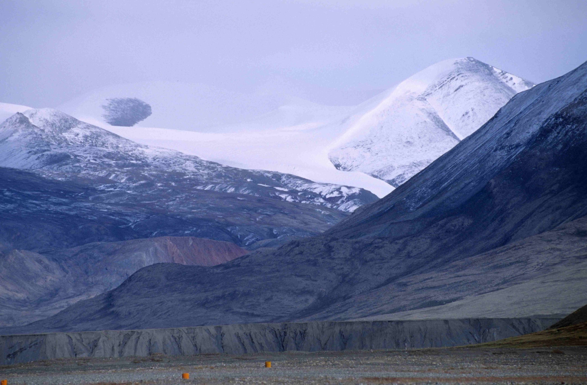
2. Macdonald River lower-valley walk
Snapshot
Itinerary
The Macdonald River valley climbs west-south-west from the head of Tanquary Fiord toward the watershed that separates the Tanquary drainage from Very River drainage to the north. The lower 8–10 km is the standard first day’s walking inland for the classic Tanquary-to-Lake Hazen backpacking traverse via the Macdonald and Very rivers — so the line is well-trodden by Parks Canada’s small number of multi-day visitors, and the warden has practical advice on the current condition of the route in any given season.
From the warden station the line crosses the river delta west of the campsite (low water in mid-morning is best), gains the lower valley floor and follows the river upstream on grass-and-gravel tundra. Walking is generally easy on dry terraces with intermittent sodden ground; there is no path. The valley rises gradually — perhaps 200 metres from the fiord head over the first ten kilometres — and the standing view back south-east toward Tanquary Fiord opens out steadily as the party climbs. Common turnaround points are the first major confluence (about six to seven kilometres from camp) or the second open-valley section (about nine kilometres). The descent retraces the line back to the warden station.
Why it is essential
The Macdonald River is one of the three named rivers that converge at the head of Tanquary Fiord and the western of the two principal land routes inland toward the Grant Land Mountains. The lower-valley walk gives a faithful sample of the southern foothill terrain — the open delta, the river-terrace walking, the steady standing view onto the Conger Range and the Ad Astra Icecap to the north — without committing to the multi-day traverse. For parties with one or two day-trips from the warden station the Macdonald and Rollrock walks are the two natural objectives, complementing the formal Kettle Lake walk and the lower Air Force valley.
Equipment
Sturdy boots, layered clothing, wind- and waterproof shell, bear spray, satellite phone, GPS, sun protection, two to three litres of water capacity, wading shoes for the smaller stream crossings. The first crossing at the delta is the only significant one; brief the warden on river state before departure.
Hazards and notes
- The Macdonald delta crossing at the start of the line can be high after warm days; check with the warden.
- The valley is non-technical; the principal hazards are weather, river state and bear awareness.
- Polar bears are documented at Tanquary; muskox herds may use the valley terraces.
- Long flat walking on uneven ground is the main physical burden; trekking poles are useful.
- Cloud can close in fast on the upper valley; carry GPS waypoints for the return line and brief the warden on planned turnaround.
GPX / KML links
| Source | URL | Format / access | Reuse status |
|---|---|---|---|
| Parks Canada — Tanquary Fiord Hiking Guide PDF | parkscanadahistory.com | PDF brochure | Parks Canada terms; no GPX |
| Parks Canada — Quttinirpaaq hiking | pc.gc.ca | Plain-text guidance | Parks Canada terms |
| NTS 1:50,000 sheets 340D and 340G | maps.canada.ca | National topographic maps | Open Government Licence — Canada |
External links
3. Rollrock River lower-valley walk
Snapshot
Itinerary
The Rollrock River drains north-north-west into the head of Tanquary Fiord between the Macdonald and Air Force deltas. Multi-day backpacking parties heading for the Viking Ice Cap and the Ad Astra circuit ascend the lower Rollrock as their day-one line, so the valley is well-trodden by Parks Canada’s small visitor stream; a lobe from the Viking Ice Cap descends into the upper Rollrock valley well beyond a single-day’s walking distance from the warden station. The lower valley itself — perhaps the first ten kilometres — is the natural day-trip objective.
From the warden station the line follows the fiord head north, picks up the lower Rollrock delta and follows the river inland on grass-and-gravel terraces. Walking is generally easy on dry tundra with intermittent sodden ground; there is no path. The valley is broader than the Macdonald at its lower end and gives a more open view of the Conger Range to the north and the southern Grant Land Mountains crest. The published-record turnaround for a single-day’s walking from the warden station is around six to nine kilometres inland — typically at a named valley feature that the warden can identify at registration. Descent retraces the line.
Why it is essential
The Rollrock is the central of the three rivers feeding the Tanquary head and the natural northern counterpart to the Macdonald walk. The two together give a fair sample of the southern foothill terrain — the open river deltas, the broad lower valleys, and the standing view north into the Grant Land Mountains crest — without committing to the multi-day Viking Ice Cap traverse. For parties with two day-trips from camp the Macdonald and Rollrock walks are the two standard objectives.
Equipment
Sturdy boots, layered clothing, wind- and waterproof shell, bear spray, satellite phone, GPS, sun protection, two to three litres of water capacity, wading shoes for the smaller stream crossings. As with the Macdonald, the delta crossing at the start is the only significant fording; brief the warden on river state.
Hazards and notes
- The Rollrock delta crossing at the start of the line can run high after warm days.
- The valley is non-technical; weather, river state and bear awareness are the principal hazards.
- Polar bears, muskox and Arctic wolves are all possible on the lower valley terraces.
- The upper Rollrock — beyond a single-day’s walking distance — leads to the Viking Ice Cap and is mountaineering terrain; do not extend beyond the warden-agreed turnaround.
- Cloud and visibility deterioration are common; carry GPS waypoints for return.
GPX / KML links
| Source | URL | Format / access | Reuse status |
|---|---|---|---|
| Parks Canada — Tanquary Fiord Hiking Guide PDF | parkscanadahistory.com | PDF brochure | Parks Canada terms; no GPX |
| Parks Canada — Quttinirpaaq hiking | pc.gc.ca | Plain-text guidance | Parks Canada terms |
| NTS 1:50,000 sheets 340D and 340G | maps.canada.ca | National topographic maps | Open Government Licence — Canada |
External links
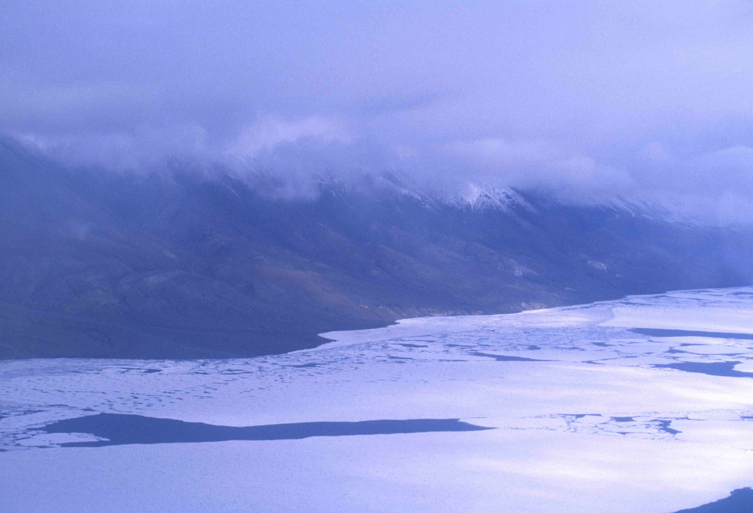
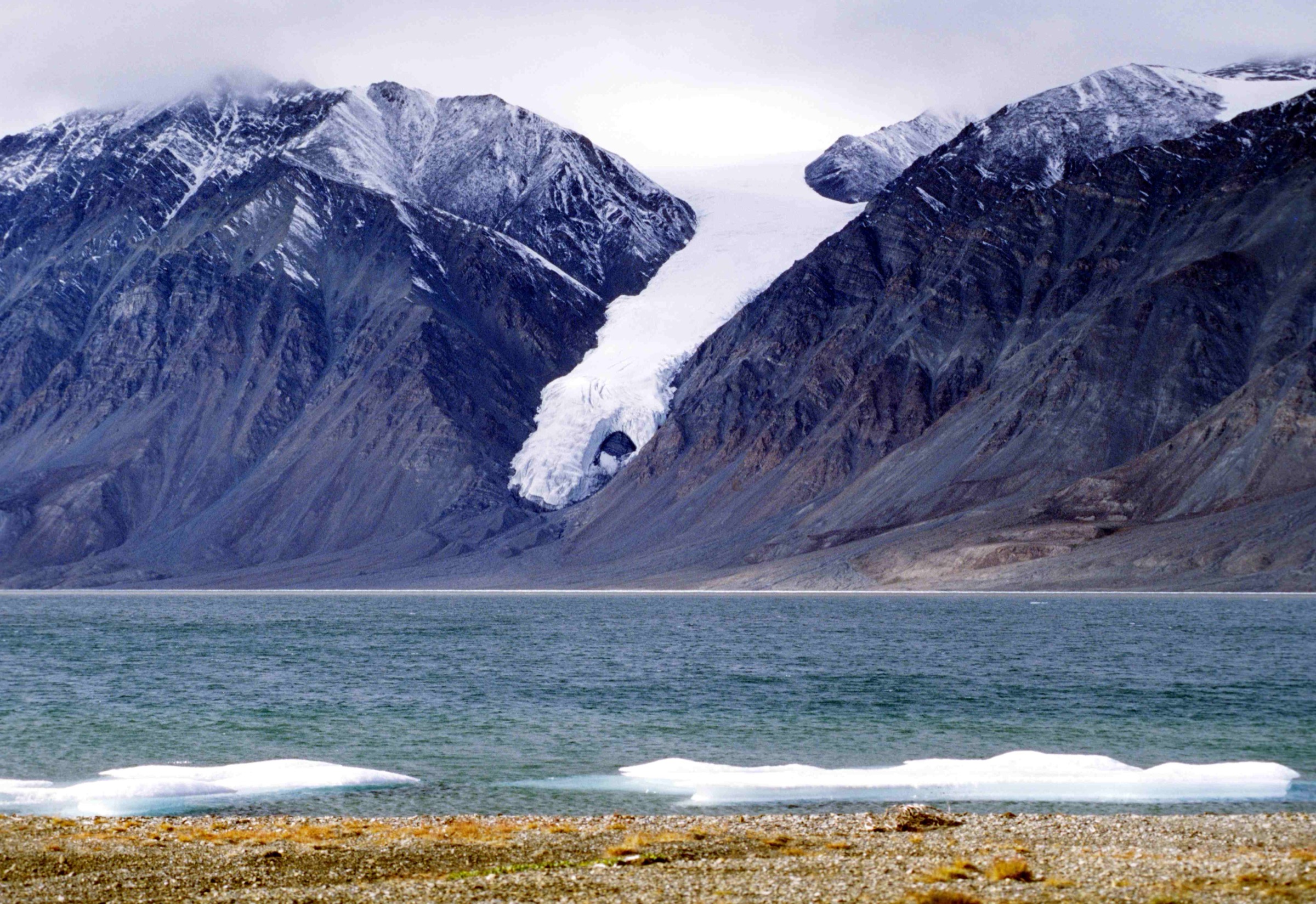
4. Gull Glacier (“Hand of God”) viewpoint walk
Snapshot
Itinerary
The Gull Glacier descends from a small upland icefield south of Tanquary Fiord and reaches the fiord head almost directly opposite the Parks Canada campsite. The glacier toe and the broad, splayed lower lobes have given the feature its informal local name — the “Hand of God” — and it is the single most distinctive landscape feature within direct sight of the warden station. Reaching a viewpoint of the toe is a half-day walking objective from camp.
The standard line follows the fiord-head shore east-south-east from the campsite for around three to five kilometres on tundra terraces, with the glacier toe directly across the fiord. Walking is on dry-to-sodden ground with intermittent gravel beach; there is no path. The shoreline does not require a fiord crossing — the viewpoint is the south-eastern side of the fiord-head, which is reachable on foot without leaving the warden-station shore. The descent retraces the line. A longer variant extends to a more elevated tundra terrace inland of the standard viewpoint for a higher perspective onto the glacier toe.
Why it is essential
The Gull Glacier is the closest named glacier landscape feature to the Tanquary warden station and the only one visible from the campsite itself. The walk gives a half-day’s outing with a glacier toe as the centrepiece of the standing view, complementing the more demanding lower Air Force valley walk-up. For parties on a weather-bound rest day or for an introductory walk on day one after the orientation, the Gull Glacier line is the natural objective.
Equipment
Sturdy boots, layered clothing, wind- and waterproof shell, bear spray, satellite phone, GPS, sun protection, binoculars for the glacier-toe view, one to two litres of water capacity.
Hazards and notes
- The fiord-shore line is non-technical; the principal hazards are weather and bear awareness.
- The shoreline narrows to gravel beach in places; intermittent wet sections require detour onto the higher tundra.
- Do not attempt to cross the fiord to the glacier toe itself; sea ice can be unreliable and Parks Canada explicitly discourages glacier-front approaches.
- Polar bears are documented on the fiord ice and shore in some seasons; brief the warden.
- The glacier toe is actively calving; remain on the warden-side shore.
GPX / KML links
| Source | URL | Format / access | Reuse status |
|---|---|---|---|
| Parks Canada — Quttinirpaaq hiking | pc.gc.ca | Plain-text guidance | Parks Canada terms |
| NTS 1:50,000 sheets 340D and 340G | maps.canada.ca | National topographic maps | Open Government Licence — Canada |
| Wikimedia Commons — Gull Glacier photo metadata | commons.wikimedia.org | Photo source page | CC BY-SA 2.5 |
External links
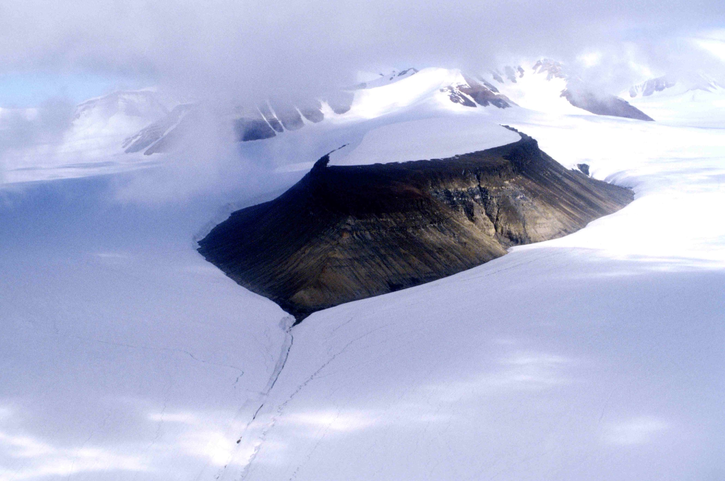
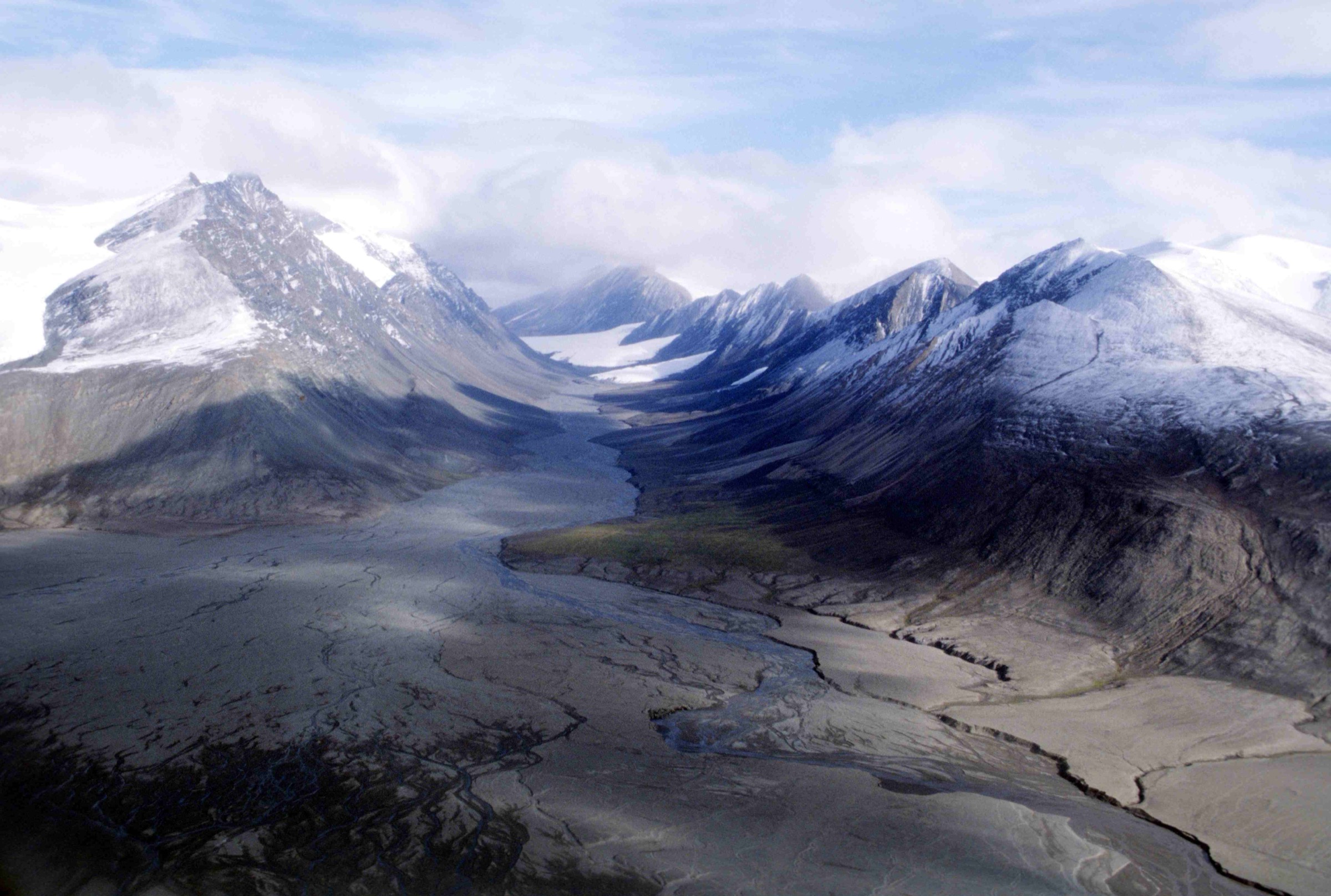
5. Lower Air Force River valley walk
Snapshot
Itinerary
The Air Force River drains the Air Force Glacier — itself an outlet of the Grant Ice Cap that fronts the southern flank of Barbeau Peak — south-east into the head of Tanquary Fiord. The American Alpine Journal expedition reports for Barbeau ascents describe the standard descent line from summit basecamp as down the Air Force Glacier toe and out along the lower Air Force River valley to the warden station. The lower-valley walk — covering the first ten to twelve kilometres inland from the campsite — is the longest of the four valley walks and approaches the glacier-toe view that no other day-trip from Tanquary delivers.
From the warden station the line crosses the Air Force delta east of the campsite (low water in mid-morning is best) and follows the lower valley floor inland on grass-and-gravel tundra. Walking is generally easy with intermittent sodden ground; the valley rises perhaps 200 to 400 metres over the first ten kilometres. The line passes the lower valley junction with a smaller tributary and continues on the open valley floor toward the glacier-toe view. A sensible single-day turnaround is in the order of eight to twelve kilometres inland — a long but feasible day from the warden station that gives a fair view onto the Air Force Glacier toe and the Fiala Glacier confluence beyond.
The full toe-of-Air Force-Glacier objective is not a single-day’s walking from the warden station for most parties; the glacier toe sits roughly 30 to 40 kilometres inland and is a multi-day commitment. The valley is included in this list because the lower-valley walk is the closest day-trip approach to the Grant Ice Cap and Barbeau Peak terrain that the casual walker can reach from Tanquary.
Why it is essential
The Air Force River is the eastern of the three rivers feeding Tanquary Fiord and the only one of the three that ascends directly toward the Grant Ice Cap and the high range. The lower-valley walk gives the closest day-trip approach to the central ice mass of the Grant Land Mountains — and to the southern flanks of Barbeau Peak — within day-trip range of the warden station. The line is included as the natural step-up from the Macdonald and Rollrock valley walks, with a longer day and a more dramatic standing view as the reward.
Equipment
Sturdy boots, full layered clothing system, wind- and waterproof shell, bear spray, satellite phone, GPS with NTS 340D and 340G loaded, sun protection, three litres of water capacity, trekking poles for the long flat walking, headlamp despite 24-hour daylight, wading shoes for the Air Force delta crossing. Glacier-grade sunglasses for the upper valley.
Hazards and notes
- The Air Force delta crossing is the most significant single hazard on this line; brief the warden on river state before departure, and turn back if the river is high.
- The valley is non-technical but long; total walking distance approaches the upper limit of a comfortable day from the warden station.
- Weather can deteriorate fast in the inner valley with the Grant Ice Cap above; expect rapid temperature drops on the upper line.
- Cloud and visibility deterioration are common; carry GPS waypoints for return.
- Do not extend onto the glacier toe itself without crampons, rope and crevasse-rescue equipment — the Air Force Glacier toe is an active mountaineering surface.
- Brief the warden in detail before departure and agree a check-in time.
GPX / KML links
| Source | URL | Format / access | Reuse status |
|---|---|---|---|
| Parks Canada — Tanquary Fiord Hiking Guide PDF | parkscanadahistory.com | PDF brochure | Parks Canada terms; no GPX |
| Parks Canada — Quttinirpaaq hiking | pc.gc.ca | Plain-text guidance | Parks Canada terms |
| NTS 1:50,000 sheets 340D and 340G | maps.canada.ca | National topographic maps | Open Government Licence — Canada |
| AAC Publications — Many First Ascents Near Barbeau Peak | publications.americanalpineclub.org | Expedition report | American Alpine Club terms |
External links
Missing data and follow-up work
- No published GPX tracks exist for any walk in this article. Parks Canada loans GPS units pre-loaded with Kettle Lake waypoints at the warden station; those waypoint files are not published online. The Tanquary Fiord Hiking Guide is a 5.6 MB PDF whose precise distance recommendations are inside the brochure; values quoted here are the inferable single-day objectives derived from the brochure cover material, the Wikipedia and Wikivoyage Tanquary entries, the Ansgar Walk 1997 photo metadata, and the published American Alpine Journal expedition reports.
- Tanquary Fiord warden station coordinates are quoted variously in published sources between roughly 81°00′N and 81°25′N; the article uses about 81°22′N 77°W as an indicative figure and refers the reader to Parks Canada for the precise position.
- Name “Grant Land Mountains” vs. formal sub-range names — Wikipedia and modern Parks Canada usage subdivide the upland complex into the formal British Empire Range, United States Range and Challenger Mountains. The article uses “Grant Land Mountains” as the user-supplied umbrella term and notes the sub-ranges in the regional overview.
- Landmark-specific high-resolution photographs for the lower Macdonald valley, the lower Rollrock valley, and the Air Force River valley specifically (rather than the Air Force Glacier above) do not exist on Wikimedia Commons under reusable licences. Per-hike figures are taken from the Ansgar Walk 1997 Ellesmere series; figcaptions are honest about the illustrative use.
- Charter flight cost is quoted as a 2024 ballpark of C$60,000–70,000 per Twin Otter leg; the figure varies substantially with fuel cost and operator scheduling. Confirm current rates with Kenn Borek Air at the planning stage.
- First-ascent attribution for Barbeau Peak — the historical record gives 7 June 1967, led by Geoffrey Hattersley-Smith of the Defence Research Board with Keith Arnold and four Royal Air Force party members; this corrects an earlier guidebook attribution of “Patterson, Boucher” that the published record does not support.
External links
| Source | URL |
|---|---|
| Parks Canada — Quttinirpaaq National Park | parks.canada.ca |
| Parks Canada — Quttinirpaaq hiking | pc.gc.ca |
| Parks Canada — Kettle Lake Walking Tour brochure | parks.canada.ca |
| Parks Canada — Tanquary Fiord Hiking Guide PDF mirror | parkscanadahistory.com |
| Parks Canada — plan your visit | parks.canada.ca |
| Quttinirpaaq 2023 Management Plan | parks.canada.ca |
| Wikipedia — Quttinirpaaq National Park | en.wikipedia.org |
| Wikipedia — Tanquary Fiord | en.wikipedia.org |
| Wikipedia — Grant Land | en.wikipedia.org |
| Wikipedia — British Empire Range | en.wikipedia.org |
| Wikipedia — Barbeau Peak | en.wikipedia.org |
| Wikipedia — Operation Hazen | en.wikipedia.org |
| Wikipedia — Geoffrey Hattersley-Smith | en.wikipedia.org |
| Wikivoyage — Quttinirpaaq National Park | en.wikivoyage.org |
| AAC Publications — Many First Ascents Near Barbeau Peak | publications.americanalpineclub.org |
| Inuit Heritage Trust | ihti.ca |
| Polar Continental Shelf Program | nrcan.canada.ca |
| Kenn Borek Air | borekair.com |