Regional overview
The Northern Coast Mountains form the most northerly of the three formal subdivisions of British Columbia’s Coast Mountains, sweeping from the Nass and Skeena drainages along the Boundary Ranges to the BC–Alaska border and the fringes of the Stikine Icecap. The defining features are deep glacial fjords (Portland Canal, Khutzeymateen, Observatory Inlet), large valley glaciers descending from the Cambria Icefield and Stikine Icecap, and a vast expanse of coastal western hemlock and Sitka spruce rainforest yielding to a short, stunted subalpine and a wind-blasted alpine. Annual precipitation along the outer coast and around Stewart commonly exceeds 2,500 mm, much of it as winter snow that lingers at altitude well into July.
The main hiking gateways are Prince Rupert on Kaien Island, at the mouth of the Skeena; Terrace, on the Skeena, at the convention boundary with the Kitimat Ranges; Stewart, at the head of Portland Canal in the Boundary Ranges; and Gitlaxt’aamiks (New Aiyansh) in the Nass Valley. The Nass Valley adds a unique element to the region: the Tseax volcanic field, source of Canada’s most recent confirmed volcanic eruption (c. 1700 CE), preserved within Anhluut’ukwsim Lax̱mihl Angwinga’asanskwhl Nisg̱a’a / Nisga’a Memorial Lava Bed Provincial Park — the first park in BC jointly managed by a First Nation and the province.
Terrain is uncompromising: roadless backcountry beyond a thin highway corridor, very steep relief from sea level to 2,000 m peaks within a few horizontal kilometres, persistent wet weather, dense devil’s club and slide-alder bushwhacking on neglected trails, and large grizzly populations (notably around the Khutzeymateen estuary and along the Nass and Bear rivers). The reliable alpine season runs roughly mid-July to early September; lowland and rainforest trails near Prince Rupert and Terrace remain walkable April to October with the caveat of extreme rainfall.
Access is via Highway 16 (Yellowhead) west from Prince George to Terrace and Prince Rupert; Highway 37 (Stewart–Cassiar) north from Kitwanga; and the 65 km spur of Highway 37A (the Glacier Highway) west into Stewart. BC Ferries’ Inside Passage and Haida Gwaii routes terminate at Prince Rupert. Safety considerations include grizzly density (carry bear spray as standard equipment), very limited or no cell coverage outside the towns, unpredictable frontal-system weather, glacier and crevasse hazards on or near ice, and limited or weather-restricted helicopter rescue.
Selection rationale
The five hikes below span the four physiographic settings that define this subdivision (coastal rainforest, summit/ridgeline, glacier viewpoint and Nisga’a volcanic landscape), remain genuinely day-feasible, and draw on the three sustained hiking communities of Prince Rupert, Stewart and the Nass Valley. Famous fjord features (Khutzeymateen, Misty Fiords) are excluded because they have no road-accessible Canadian-side day hike; multi-day routes such as Mount Edziza are out of scope.
Sleeping Beauty Mountain (Terrace) was reviewed and is documented under the companion Kitimat / Bella Coola entry, where Wikipedia and PeakVisor place the peak in the Kitimat Ranges. Mount Hays (Prince Rupert) sits at a similar overlap point on Kaien Island and is flagged accordingly.
Summary table
| # | Hike | Country | Route type | Distance | Gain | Max elevation | Difficulty |
|---|---|---|---|---|---|---|---|
| 1 | Butze Rapids Loop | Canada | Loop | ~5 km | ~140 m | ~100 m | Easy |
| 2 | Mount Hays via Kiwanis Trail | Canada | Out-and-back | ~8.3 km | ~650 m | ~700–732 m (sources vary) | Hard |
| 3 | Ore Mountain Trail (Stewart) | Canada | Out-and-back | ~11 km | ~940 m | ~1,150 m | Hard |
| 4 | Salmon Glacier Summit Viewpoint walks | Canada (access via Hyder, USA) | Short out-and-backs from road | ~1–4 km variable | ~50–200 m | ~1,145 m | Easy–Moderate |
| 5 | Vetter Falls + Crater Creek interpretive trails (Nisga’a Memorial Lava Bed) | Canada | Combined short out-and-backs | ~3–5 km combined | <30 m each | ~250 m | Easy |
1. Butze Rapids Loop
Snapshot
Itinerary
The trail begins from a signed Highway 16 pull-off about 5 km east of downtown Prince Rupert. It is a 5 km easy, well-maintained, mostly chip-covered interpretive loop through coastal western hemlock and Sitka spruce rainforest with frequent muskeg openings. At roughly 1.8 km from the trailhead a wooden viewing platform overlooks the Butze Rapids — a tidal reversing rapid in Fern Passage created by the difference in tidal phase between Prince Rupert Harbour and Morse Basin around Kaien Island. The loop continues from the viewpoint back through forest and muskeg to the trailhead.
Why it is essential
The reversing tidal rapid is the only easily accessible large hydraulic feature of its kind on the BC north coast, and the loop is the most accessible introduction to the Great Bear Rainforest character of Kaien Island and the wider Northern Coast Mountains lowlands.
Equipment
- Standard rainforest day-hike kit: waterproof shell, waterproof boots.
- Snacks and water.
- Bear spray (a small but present black-bear population on Kaien Island).
- Insect repellent in summer.
Hazards and notes
- The trail is signposted and benched but consistently wet; boardwalk sections are slick when frosted.
- The viewpoint is unrailed at the cliff edge above the rapids — exercise caution with children.
- Black bears are present; grizzlies are uncommon on Kaien Island but not impossible.
- Tides should be checked before the visit if a reversing-current photo is the objective.
GPX / KML links
| Source | URL | Format / access | Reuse status |
|---|---|---|---|
| Recreation Sites and Trails BC — Butze Rapids Interpretive Trail (REC6575) | sitesandtrailsbc.ca | Official trail record | No GPX confirmed; provincial terms vary |
| OpenStreetMap | openstreetmap.org | OSM XML / GPX export | ODbL; reusable with attribution |
| AllTrails community trace | alltrails.com | Community trace | AllTrails terms; not redistributable |
External links
2. Mount Hays via Kiwanis Trail
Snapshot
Itinerary
The Kiwanis Trail leaves a small parking area near the Oldfield Creek Fish Hatchery in southwest Prince Rupert and climbs steeply through coastal rainforest and muskeg. Trail reports describe the route as steep, root-laden and frequently overgrown, with marshy sections that hold standing water through the summer. After roughly 3 km the gradient eases and the trail enters subalpine heath; the route then meets and partly joins the gravel service road that climbs to the summit antenna site. The true summit is a concrete monolith marking the top of the former Mount Hays gondola installation. Views encompass Prince Rupert Harbour, Chatham Sound, the southern Tsimshian Peninsula and, on clear days, the southeast tip of Annette Island in Alaska.
Why it is essential
Mount Hays is the only substantial alpine summit in the immediate Prince Rupert area reachable from town on foot in a day. It provides the regionally signature view of the working harbour, the Skeena estuary and the outer coast.
Equipment
- Mountain hiking equipment, robust waterproofs and gaiters (mud is constant).
- Microspikes if attempting before late June.
- Bear spray; insect head net in July–August.
- Satellite communicator recommended; cell reception is patchy off-summit.
- Wind shell — the summit is exposed even on calm days lower down.
Hazards and notes
- Trail marking is variable and route-finding can be problematic in the marshy mid-section.
- Loose roots and wet rock make descent slips a real injury risk.
- Service-road traffic to the antenna site is rare but possible; yield to vehicles.
- Black bears are regular along the lower trail; grizzlies uncommon on Kaien Island.
GPX / KML links
| Source | URL | Format / access | Reuse status |
|---|---|---|---|
| Trailpeak — Mount Hays via the Kiwanis Trail | trailpeak.com | Community description | Site terms; not reusable |
| AllTrails community trace | alltrails.com | Community trace | AllTrails terms; not redistributable |
| OpenStreetMap | openstreetmap.org | OSM XML / GPX export | ODbL; reusable with attribution |
External links
3. Ore Mountain Trail (Stewart)
Snapshot
Itinerary
From the Clements Lake Recreation Site pull-off on Highway 37A, walk 300 m along an old road to the signed trailhead. The trail climbs the east side of the Bear River valley steeply through old growth, with sustained gradient and considerable deadfall in the lower 3 km. At about 3 km the timber thins and a recognised viewpoint over the Bear River valley, the toe of Bear Glacier and the Cambria Icefield outflow is reached. The marked tread continues another kilometre or so through subalpine fir and mountain hemlock to break into open heath; a rougher, unmarked continuation leads to a small unnamed alpine tarn near the trail’s nominal end. Return is by the same line.
Why it is essential
Ore Mountain is the most reliable single-day alpine outing in the Stewart area and delivers the signature Boundary Ranges experience — heavy hemlock-spruce forest below, an abrupt break into open subalpine, and direct views onto a major valley glacier and the southern margin of the Cambria Icefield.
Equipment
- Mountain hiking equipment: microspikes for residual snow into July.
- Robust waterproof shell.
- Trekking poles strongly recommended for the steep descent.
- Bear spray (grizzlies known on the Bear River drainage).
- Satellite communicator essential — no cell coverage. Headtorch in shoulder season.
Hazards and notes
- The trail is unmaintained above the named viewpoint; route-finding becomes the responsibility of the party in the upper basin.
- Cornices can persist on north aspects above the tarn into August.
- Bears are common; Clements Lake itself is a popular fishing site.
- Trip reports note significant deadfall and washouts.
- Highway 37A is reliable in summer but can close briefly in winter avalanche cycles.
GPX / KML links
| Source | URL | Format / access | Reuse status |
|---|---|---|---|
| Recreation Sites and Trails BC — Ore Mtn. Tr. (REC0996) | sitesandtrailsbc.ca | Official trail record | No GPX confirmed; provincial terms vary |
| Trailpeak — Ore Mountain Trail | trailpeak.com | Community description | Site terms; not reusable |
| OpenStreetMap | openstreetmap.org | OSM XML / GPX export | ODbL; reusable with attribution |
External links
4. Salmon Glacier Summit Viewpoint walks

Snapshot
Itinerary
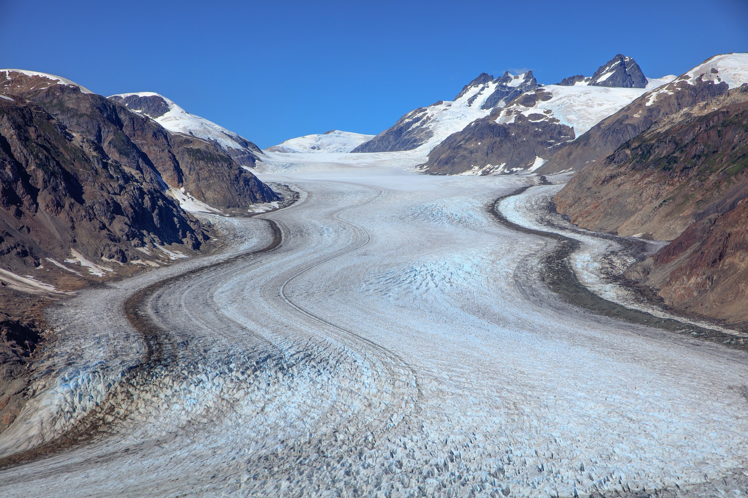
The hike here is the cluster of informal foot routes radiating from the Summit Viewpoint pull-off on Granduc Road, the main vantage over the Salmon Glacier — a tongue of the Cambria Icefield system and the fifth-largest glacier in Canada. The viewpoint sits at about 1,145 m. From the pull-off, informal paths climb across the road into open heath and alpine wildflower meadows in July and August, joining a single use-path along the rocky ridge above the glacier. Several variants exist: a short 10–15 minute walk to a rocky knoll above the road; a longer ridge wander of 1–2 hours through meadows to additional viewpoints over a small unnamed glacier on the ridge; and (for experienced parties only) further extensions toward the head of the glacier. Access from Stewart involves driving 4 km south to Hyder, Alaska (no US border post), then 37 km north on Granduc Road; returning involves the Canadian border post (passport required).
Why it is essential
Outside of fly-in operations, the Summit Viewpoint is the only place in the Coast Mountains where a roadside walk delivers a direct overview of an active valley glacier of this scale, with an icefall, terminus and proglacial lake all in one panorama. Wildflower display in July and August is exceptional.
Equipment
- Standard day-hike kit.
- Passport (mandatory for return into Canada).
- High-clearance vehicle for Granduc Road; spare tyre, water and warm layers.
- Bear spray; satellite communicator recommended.
- Microspikes only if attempting before late June.
Hazards and notes
- Granduc Road is an active mining road: narrow, unsealed, no guardrails, exposed drop-offs, dust, and occasional industrial traffic.
- Snow can block the road into late June.
- The ridges above the viewpoint are open and unmarked — crevasse hazard exists on the small ridge glaciers; stay off ice without proper equipment.
- Border crossing: re-entry into Canada via the Stewart port requires passport or NEXUS, with limited shoulder-season hours. There is no US Customs post at Hyder when entering Alaska.
- Cell service is nil.
GPX / KML links
| Source | URL | Format / access | Reuse status |
|---|---|---|---|
| District of Stewart — Glacier Highway self-guided auto tour (PDF) | districtofstewart.com | Official PDF | Government / tourism; reference only |
| OpenStreetMap (Granduc Road) | openstreetmap.org | OSM XML / GPX export | ODbL; reusable with attribution |
External links
- Stewart Tourism — Salmon Glacier
- District of Stewart — Glacier Highway auto tour (PDF)
- Wikipedia — Salmon Glacier
5. Vetter Falls and Crater Creek interpretive trails (Nisga’a Memorial Lava Bed)
Snapshot
Itinerary
The lava-bed interpretive system comprises five short signed walks along Highway 113 inside Anhluut’ukwsim Lax̱mihl Angwinga’asanskwhl Nisg̱a’a Park. A representative day plan visits at least three:
- Vetter Falls / Vetter Creek Trail — a 5-minute walk from the highway pull-off through Sitka spruce to a wooden viewing platform overlooking the falls (about 0.5 km return; ~10 m gain).
- Crater Creek / Ksi Wil Ksi-Baxhl Mihl Trail — about 600 m return, 15–20 minutes, through jumbled aa lava to a viewpoint where the lava emerged from the cone area. The source of the eruption was the Tseax Cone; the lava flow buried two Nuxalk villages around c. 1700 CE.
- Beaupré Falls Trail — about 1 km return to a cascading waterfall.
- Tree Mould Trail and Fish Wheel Trail are also part of the network.
The Tseax Cone (Beaupré Cone) summit hike itself is not freely accessible. Unguided access to the cone is prohibited; visiting the crater is permitted only on a guided tour with Nass Valley Tours, run by a Nisga’a guide a few days a week from late June to early September. The guided tour is about 6 km and 4 hours of moderate hiking; reservations and a fee are required through the Nisga’a Visitor Centre or Nass Valley Tours.
Why it is essential
These walks together access the youngest confirmed volcanic landscape in Canada (c. 1700 CE eruption), the only park in BC jointly managed by a First Nation and the province under the 2000 Nisga’a Treaty, and a cultural landscape of profound importance — the lava flow buried two villages and killed an estimated 2,000 Nisga’a people. Interpretation is grounded in Nisga’a oral history (adaawak).
Equipment
- Standard light walking kit; sturdy footwear (lava rock is very sharp).
- Insect repellent in summer; water; bear spray.
- For the guided cone tour: longer hiking trousers, sun protection, drinking water, no off-trail wandering.
Hazards and notes
- Lava rock is sharp; trails over it can be uneven. Long trousers are recommended on Crater Creek.
- Off-trail access onto the lava bed and to the cone is prohibited under park regulations to protect cultural and geological features.
- Joint management protocols are set by Nisga’a Lisims Government and BC Parks — respect them.
- Bears (both species) frequent the Nass Valley.
- Photography is generally permitted but may be restricted at culturally sensitive sites; defer to onsite signage and guides.
GPX / KML links
| Source | URL | Format / access | Reuse status |
|---|---|---|---|
| BC Parks: Nisga’a Memorial Lava Bed Park | bcparks.ca | Official description | BC Parks website terms not evaluated; no GPX found |
| OpenStreetMap | openstreetmap.org | OSM XML / GPX export | ODbL; reusable with attribution |
External links
- BC Parks — Anhluut’ukwsim Lax̱mihl Angwinga’asanskwhl Nisg̱a’a / Nisga’a Memorial Lava Bed Park
- Wikipedia — Nisga’a Memorial Lava Bed Provincial Park
- Wikipedia — Tseax Cone
External links
| Source | URL |
|---|---|
| BC Parks — Anhluut’ukwsim Lax̱mihl Angwinga’asanskwhl Nisg̱a’a / Nisga’a Memorial Lava Bed | bcparks.ca |
| BC Parks — Bear Glacier Park | bcparks.ca |
| Recreation Sites and Trails BC — Butze Rapids Interpretive Trail | sitesandtrailsbc.ca |
| Recreation Sites and Trails BC — Ore Mountain Trail | sitesandtrailsbc.ca |
| Visit Prince Rupert — Hiking Butze Rapids | visitprincerupert.com |
| Stewart Tourism — Hiking | stewart-tourism.com |
| Stewart Tourism — Salmon Glacier | stewart-tourism.com |
| Stewart Tourism — Bear Glacier | stewart-tourism.com |
| District of Stewart — Glacier Highway auto tour (PDF) | districtofstewart.com |
| Trailpeak — Mount Hays via Kiwanis Trail | trailpeak.com |
| Trailpeak — Ore Mountain Trail | trailpeak.com |
| Wikipedia — Coast Mountains | en.wikipedia.org |
| Wikipedia — Cambria Icefield | en.wikipedia.org |
| Wikipedia — Salmon Glacier | en.wikipedia.org |
| Wikipedia — Nisga’a Memorial Lava Bed Provincial Park | en.wikipedia.org |
| Wikipedia — Tseax Cone | en.wikipedia.org |
| Wikipedia — Kaien Island | en.wikipedia.org |