Regional overview
The Chilcotin Ranges sit on the eastern flank of the southern Coast Mountains in interior British Columbia, between the Fraser Plateau and the more heavily glaciated Pacific Ranges. The defining hiking centres are South Chilcotin Mountains Provincial Park, around Gold Bridge, Tyaughton Lake and Spruce Lake; Big Creek Provincial Park further north on the Chilcotin plateau side; and Ts’ilʔos (Ts’yl-os) Provincial Park around Chilko Lake. Mount McLean above Lillooet sits at the southeastern margin of the range and provides one of the few road-accessible summit objectives.
The landscape is unusual for the Coast Mountains. The rain shadow of the Pacific Ranges keeps the area drier and warmer than the coast, and broad alpine meadows, rust-coloured volcanic ridges and chains of small lakes replace heavy forest and ice. South Chilcotin Mountains Park alone contains over 200 km of interconnecting trails, but most were built for horse parties, hunters and miners rather than weekend hikers; many classic routes are multi-day backpacks or shuttled mountain-bike rides, and a true one-day version often means turning around at an alpine pass or basin rather than completing a loop.
Access is the dominant constraint. Trailheads sit at the end of long forest service roads — the Hurley FSR from Pemberton, Highway 40 along Carpenter Lake from Lillooet, the Slim Creek, Mud Creek and Taylor Creek FSRs into the South Chilcotin park, and the gravel roads from Hanceville or Tatla Lake into Ts’ilʔos. Higher-clearance vehicles are normal, and 4WD is required for some approaches. There is no public transport into any of these trailheads, no cell coverage across most of the region, and bear (grizzly and black) encounters are routine. Satellite communication, bear spray and conservative trip planning are appropriate on every route below.
The walking season is short. Snow normally lingers in the alpine into late June and returns from late September; the most reliable window is mid-July to early September. Dogs are prohibited in South Chilcotin Mountains Park because of grizzly density, and are strongly discouraged in Ts’ilʔos. Several access roads have recent washouts or seasonal closures (the Hurley is typically open mid-May to late October), and conditions need to be confirmed locally before any trip.
Selection rationale
The five selected hikes balance an iconic lake-and-valley objective (Spruce Lake), a classic alpine pass (Windy Pass), a colourful mining-history basin (Taylor Basin), a Ts’ilʔos summit viewpoint over Chilko Lake (Tullin Mountain), and a strenuous Coast-edge summit accessible from Lillooet (Mount McLean). They cover the four main hiking centres of the range and represent its three signature landscapes: the rust-and-red volcanic ridges of the South Chilcotin, the deep turquoise glacial lakes of Ts’ilʔos, and the dry interior summits above Lillooet. Multi-day classics such as Spectrum Pass, Lorna Pass, Yohetta Valley and Tchaikazan Valley were excluded because no realistic one-day version exists from a road trailhead. Big Creek Provincial Park was considered but has no road access to the park boundary and is not feasible as a day-hike destination.
Summary table
| # | Hike | Country | Route type | Distance | Gain | Max elevation | Difficulty |
|---|---|---|---|---|---|---|---|
| 1 | Spruce Lake via Gun Creek Trail | Canada | Out-and-back | 15.8 km | approx. 820 m | approx. 1,600 m | Hard |
| 2 | Windy Pass from Eldorado Basin | Canada | Out-and-back | 10 km | 600 m | approx. 2,250 m | Hard |
| 3 | Taylor Creek to Taylor Basin | Canada | Out-and-back | 13–19 km | 700–850 m | approx. 2,100 m | Hard |
| 4 | Tullin Mountain (Ts’ilʔos / Chilko Lake) | Canada | Out-and-back | 14 km | 870 m | approx. 1,786 m | Hard |
| 5 | Mount McLean above Lillooet | Canada | Out-and-back | approx. 25 km | approx. 2,170 m | approx. 2,430 m | Very hard |
1. Spruce Lake via Gun Creek Trail
Snapshot
Itinerary
The route starts at the Jewel Bridge / Jewel Creek trailhead, reached by following the Slim Creek FSR approximately 12–13 km north from Highway 40, about 7 km east of Gold Bridge. From the bridge, the Gun Creek Trail climbs gently through lodgepole pine and aspen along the north side of Gun Creek, opening at intervals to grassland and mid-elevation meadow with views across to Mount Sheba and the Shulaps Range. The path crosses a series of side creeks and passes the Hummingbird Lakes turn-off before reaching the south end of Spruce Lake, where a designated wilderness campground sits among open meadow at the foot of a long ridge. Strong parties extend the day by continuing 1.5 km along the lake to the second campsite or by climbing the short side-trail toward Windy Pass for a higher viewpoint before returning along the same route.
Why it is essential
Spruce Lake is the keystone destination of the southern half of South Chilcotin Mountains Park. The lake, the meadows above it and the colour-banded peaks visible from its shore are the image most associated with the South Chilcotin in BC Parks and tourism material, and the Gun Creek Trail is the most reliable access into that landscape from a road trailhead.
Equipment
- Mountain hiking equipment for a long remote day.
- Sturdy boots, trekking poles, layered warm and waterproof clothing.
- Water filter or treatment, bear spray and a satellite communicator.
- Bear-aware food handling at any break stop; designated food caches exist at the lake campsites.
- Dogs are prohibited in the park.
Hazards and notes
- Grizzly and black bears are common along Gun Creek; make noise and travel in a group.
- The Slim Creek FSR has been periodically blocked or rough; check current status before committing to the drive.
- No cell coverage; carry a satellite messenger.
- The route is unmaintained in places and can be wet after rain or during early-season runoff.
- Distance and gain are taken from a secondary trail database and have not been confirmed against an official BC Parks figure.
GPX / KML links
| Source | URL | Format / access | Reuse status |
|---|---|---|---|
| AllTrails — Spruce Lake via Gun Creek Trail | alltrails.com | App track | AllTrails terms apply; GPX reuse unresolved |
| BC Parks — South Chilcotin trail map (PDF) | nrs.objectstore.gov.bc.ca | Georeferenced PDF map | BC Parks terms not evaluated; official map, not a hiking GPX |
| Trailforks — Mid Gun Creek Trail | trailforks.com | App track | Trailforks terms apply; GPX reuse unresolved |
External links
- BC Parks — South Chilcotin Mountains Park
- BC Parks — South Chilcotin trail map (PDF)
- AllTrails — Spruce Lake via Gun Creek Trail
2. Windy Pass from Eldorado Basin
Snapshot
Itinerary
From the Eldorado Basin trailhead, the route follows the old Lucky Strike mining track through subalpine forest and then opens into the broad, flower-covered meadows of Eldorado Basin. The trail steepens on the final 1–2 km, climbing through scree and rock benches to the saddle of Windy Pass between the Eldorado and Gun Creek drainages. The pass sits on a colour-banded ridge with views south down Gun Creek toward Spruce Lake and north across the upper reaches of the Eldorado / Taylor system. Return is by the same route. Strong parties sometimes continue north to descend into Gun Creek as a long shuttle, but that is no longer a day hike from this trailhead.
Why it is essential
Windy Pass is the classic alpine pass objective of the South Chilcotin. The traverse through Eldorado Basin shows the meadow-and-rust landscape that defines the range, and the pass itself is a recognised connecting point used by horse, hiking and biking parties alike. As a day hike it is the strongest pass-style route in the park.
Equipment
- Full mountain hiking equipment for a remote alpine day.
- Sturdy boots, trekking poles, warm and waterproof layers.
- Map and compass, GPS or downloaded mapping; navigation backup essential.
- Bear spray and a satellite communicator.
- Sun protection — the basin is exposed.
Hazards and notes
- Grizzly bear habitat; mountain goats and marmots present in the upper basin.
- Snow can linger on the north side of the pass into mid-July.
- The Mud Creek / Paradise Creek FSR is rough; high clearance and ideally 4WD recommended.
- Weather can change rapidly; the pass is exposed and offers no shelter.
- Dogs are prohibited in the park.
- Maximum elevation is interpreted from regional topographic data; no official figure was located.
GPX / KML links
| Source | URL | Format / access | Reuse status |
|---|---|---|---|
| South Chilcotin Mountain Provincial Park reference page — Windy Pass | southchilcotinmountainprovincialpark.com | Trail description | Site terms not evaluated; no GPX file located |
| Trailforks — Taylor Basin / Windy Pass / Gun Creek route | trailforks.com | App track | Trailforks terms apply; multi-day route, GPX reuse unresolved |
| BC Parks — South Chilcotin trail map (PDF) | nrs.objectstore.gov.bc.ca | Georeferenced PDF map | BC Parks terms not evaluated; official map, not a hiking GPX |
External links
- BC Parks — South Chilcotin Mountains Park
- South Chilcotin Mountain Provincial Park reference — Windy Pass
- Trailforks — Taylor Basin / Windy Pass / Gun Creek route
3. Taylor Creek to Taylor Basin
Snapshot
Itinerary
The Taylor Creek Trail leaves the FSR trailhead and follows an old mining road up the north side of Taylor Creek through pine forest. After several kilometres the valley opens into the broad subalpine basin under Eldorado Mountain and Taylor Peak. The old Lucky Strike cabin sits in the basin and is the most common day-hike turnaround. Stronger parties continue up the basin toward Taylor Pass for views over the head of the drainage before returning by the same route. The trail is shared with mountain bikers, horse parties and the occasional ATV outside the park boundary, and is generally well-graded by South Chilcotin standards because it follows the old miners’ track.
Why it is essential
Taylor Basin is the most accessible alpine basin in the South Chilcotin from a road trailhead and contains the cleanest expression of the range’s volcanic colour bands: rust, ochre and grey ridgelines above flower meadows. The route also carries the range’s mining history, with the Lucky Strike cabin and old workings still visible.
Equipment
- Full mountain hiking equipment for a long remote day.
- Sturdy boots, trekking poles, full weather protection.
- Map, compass, GPS or downloaded mapping.
- Water filter or treatment, bear spray and a satellite communicator.
- Insect repellent — the basin can be heavily mosquitoed in early summer.
Hazards and notes
- Grizzly bears use the basin; the area is described in trip reports as grizzly country.
- The lower trail is shared with motorised users outside the park; expect dust and noise on weekends.
- The Mud Creek / Taylor Creek FSR is passable in a normal vehicle for most of its length but rough in places; check current condition.
- Weather and visibility can change quickly on the higher ridges.
- The full Taylor Basin to Lick Creek Loop on AllTrails is about 40 km / 1,775 m gain and is not a day hike; the figures above refer only to an out-and-back into the basin.
GPX / KML links
| Source | URL | Format / access | Reuse status |
|---|---|---|---|
| AllTrails — Taylor Basin to Lick Creek Loop | alltrails.com | App track | AllTrails terms apply; stats are for the full loop, not the day-hike out-and-back |
| Trailforks — Taylor Creek Trail | trailforks.com | App track | Trailforks terms apply; GPX reuse unresolved |
| BC Parks — South Chilcotin trail map (PDF) | nrs.objectstore.gov.bc.ca | Georeferenced PDF map | BC Parks terms not evaluated; official map, not a hiking GPX |
External links
- BC Parks — South Chilcotin Mountains Park
- AllTrails — Taylor Basin to Lick Creek Loop
- Trailforks — Taylor Creek Trail
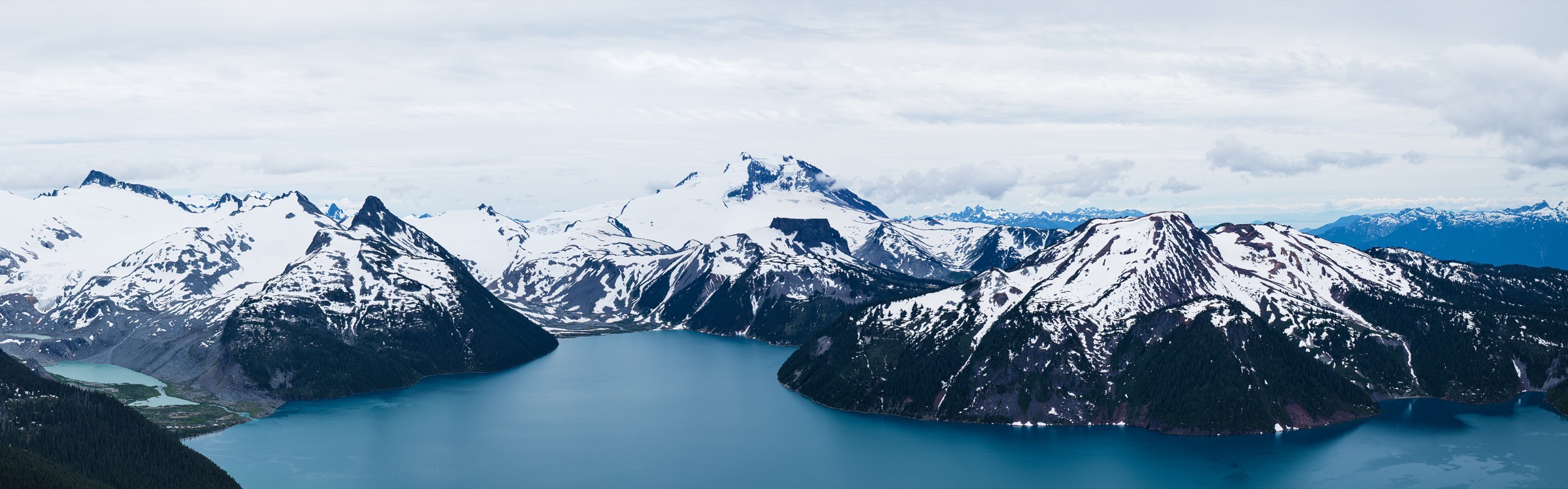
4. Tullin Mountain — Ts’ilʔos / Chilko Lake
Snapshot
Itinerary
The route starts at Gwa Da Ts’ih Campground, at the end of the gravel road in from Tatla Lake on Highway 20. The trail leaves the campground area and climbs steeply through lodgepole pine and aspen on the north side of Tullin Mountain. Orange blazes mark the line where it becomes indistinct. After a sustained ascent the path emerges from forest into open subalpine slopes with progressively bigger views down Chilko Lake to the south. The final stretch crosses open ridge and rock to the summit area, from which the long blue trench of Chilko Lake, the glaciated Niut Range to the west and Ts’ilʔos (Mount Tatlow) to the south-east are all visible. Descent is by the ascent route.
Why it is essential
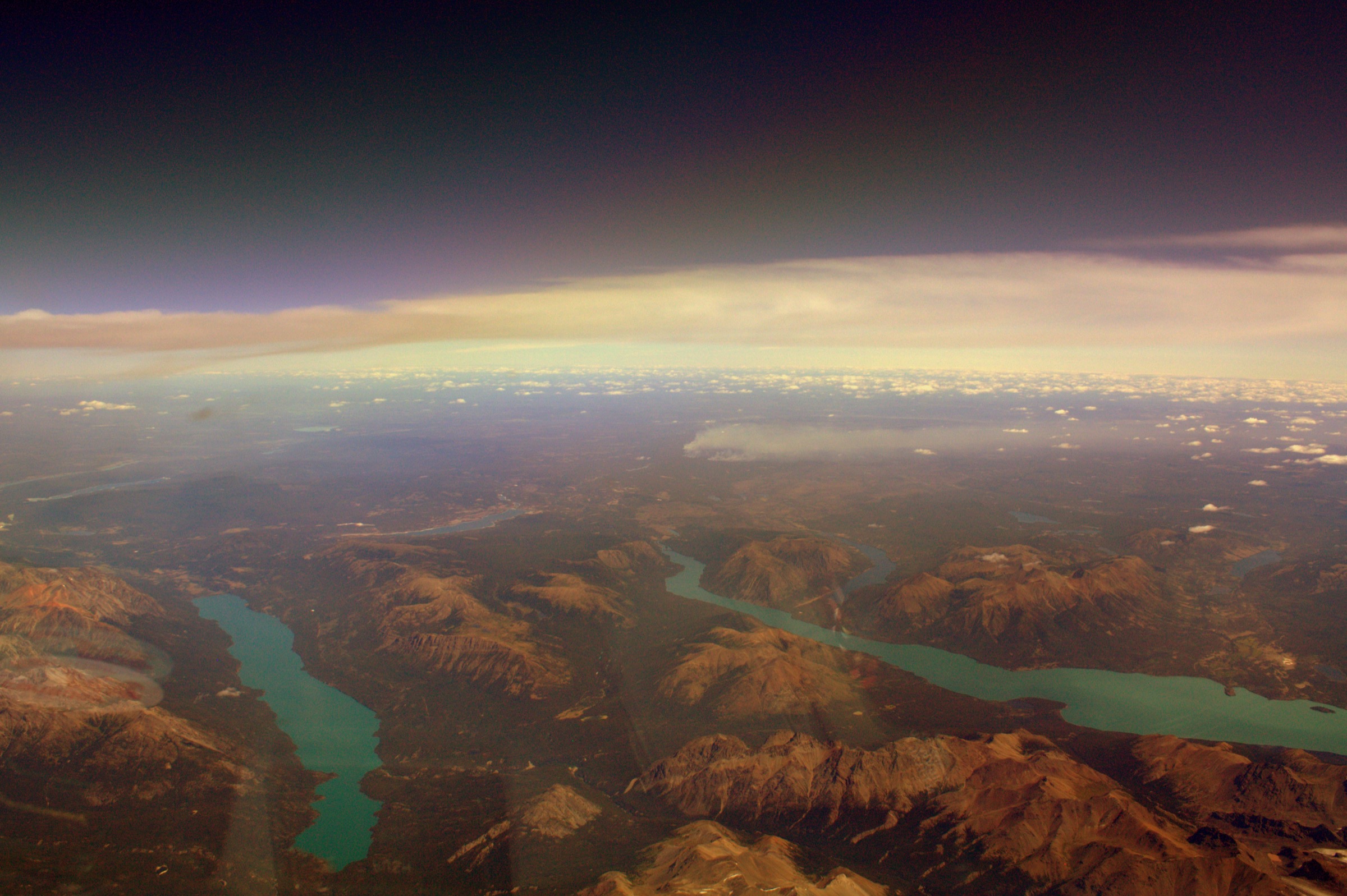
Tullin Mountain is the only well-documented summit day hike inside Ts’ilʔos Provincial Park and provides the definitive overhead view of Chilko Lake — the largest natural high-elevation lake in Canada and the cultural centre of the park’s Xeni Gwet’in landscape. It is the strongest day objective in the western Chilcotin Ranges.
Equipment
- Full mountain hiking equipment for a remote ascent.
- Sturdy boots, trekking poles, warm and waterproof layers, sun protection.
- Map and compass; the upper route is not signposted beyond orange blazes.
- Bear spray and bear-aware food handling; both grizzly and black bears are present.
- Satellite communicator — there is no rescue service in the park.
Hazards and notes
- Ts’ilʔos is a wilderness park with no rescue services; all hikers are expected to be self-sufficient.
- Grizzly bear density in Ts’ilʔos is described by BC Parks as much higher than elsewhere in the region.
- Chilko Lake is subject to sudden severe winds; the campground is exposed.
- The access road from Tatla Lake is long gravel — Williams Lake to the trailhead is 4–6 hours and may require a high-clearance vehicle.
- Cultural note: BC Parks records the Xeni Gwet’in tradition that pointing at Ts’ilʔos mountain offends Ts’ilʔos and can bring severe weather; visitors are asked to respect that protocol.
- Dogs are strongly discouraged in the backcountry.
GPX / KML links
| Source | URL | Format / access | Reuse status |
|---|---|---|---|
| BC Parks — Ts’ilʔos Park | bcparks.ca | Official trail description | BC Parks terms not evaluated; no GPX provided |
| AllTrails — Tullin Mountain | alltrails.com | App track | AllTrails terms apply; GPX reuse unresolved |
| Hiking Project — Tullin Mountain | hikingproject.com | App track | Hiking Project terms apply; GPX reuse unresolved |
External links
5. Mount McLean above Lillooet
Snapshot
Itinerary
The standard line starts at the Red Rock trailhead on the northern edge of Lillooet to avoid the original trailhead, which crosses Sek’wel’was (Cayoose Creek) reserve land and is now signed against trespass. The route climbs through arid pine and Douglas fir on long switchbacks, gaining altitude steadily on the old fire road and trail above the Fraser River. Around 1,200 m the road completes a final switchback and traverses north-west toward the upper slopes of Mount McLean. The forest gives way to open subalpine slope, then to scree and meadow. The final summit ridge is broad and offers a panorama north over the Yalakom Valley and the southern Chilcotin Ranges, west toward the Cayoosh Range, and east across the Fraser Canyon. Descent reverses the route.
Why it is essential
Mount McLean is the largest accessible summit at the southern edge of the Chilcotin Ranges and the only strenuous Coast-edge peak that can be done from a town trailhead without crossing a multi-day backcountry approach. It is the standard fitness benchmark for the Lillooet area and provides the long view over the Fraser–Bridge River confluence that defines the southeastern margin of the range.
Equipment
- Full mountain hiking equipment for a very long day.
- Sturdy boots, trekking poles, plenty of water (the lower mountain is dry and hot in mid-summer).
- Sun protection, warm and waterproof layers for the upper mountain.
- Headtorch — finishing in the dark is realistic.
- Bear spray; map and GPS for the upper switchbacks and any lingering snow.
- Microspikes or snowshoes are sometimes useful in early season.
Hazards and notes
- Heat exhaustion is a real risk on the lower mountain; start early.
- Trailhead access: the historic trailhead crosses Sek’wel’was reserve land and is signed against trespass. Use the Red Rock alternative and respect signage; confirm current trailhead status with Visit Lillooet before the trip.
- Snow can linger above 1,850 m well into July; in shoulder season it can be wet, postholing snow.
- Bear sightings on the lower trail are routine.
- Cell coverage exists in the lower Fraser corridor but is unreliable on the upper mountain.
- Maximum elevation and exact route geometry should be confirmed against a topographic source; AllTrails statistics use the full historic route from town.
GPX / KML links
| Source | URL | Format / access | Reuse status |
|---|---|---|---|
| AllTrails — Mount McLean | alltrails.com | App track | AllTrails terms apply; GPX reuse unresolved |
| Steven Song — Mount McLean trip report | stevensong.com | Trip report | Personal site; terms not evaluated, not a hiking GPX |
| Visit Lillooet — Red Rock Trail | visitlillooet.ca | Trail description | Tourism site terms not evaluated; trailhead reference, no GPX |
External links
Missing data / follow-up work
- No official BC Parks distance or elevation statistics were located for any of the five hikes; all figures are taken from secondary trail databases (AllTrails, Trailforks) or interpreted from topographic context. Official figures should be confirmed where possible.
- The BC Parks South Chilcotin trail report PDF is the most likely source of canonical statistics but could not be parsed in this pass; it should be re-fetched and read manually.
- No GPX file with an explicit reusable licence was located for any of the five hikes. All available tracks sit behind AllTrails or Trailforks terms.
- The Tullin Mountain figure uses an aerial view of Chilko Lake (the lake the summit overlooks) rather than the summit itself; no Tullin-specific CC image was located. The Windy Pass figure block uses a Wolverine Pass image from the same alpine system rather than Windy Pass itself.
- Maximum-elevation figures for Windy Pass, Taylor Basin and Mount McLean are interpreted rather than sourced; they should be confirmed against a 1:50 000 topographic map.
- Mount McLean trailhead access is sensitive: the historic route crosses Sek’wel’was reserve land. Current trailhead status and any First Nation guidance should be confirmed with Visit Lillooet before each season.
- Road status for the Hurley FSR, Slim Creek FSR and Mud Creek / Taylor Creek FSR changes year to year; any final published version should include a current-season check.
- Big Creek Provincial Park was considered and excluded because it has no road access to the park boundary; if a future pass identifies a feasible day-hike approach from Tyaughton Creek or Relay Creek, it would be a strong candidate.
External links
| Source | URL |
|---|---|
| BC Parks — South Chilcotin Mountains Park | bcparks.ca |
| BC Parks — Ts’ilʔos Park | bcparks.ca |
| BC Parks — Big Creek Park | bcparks.ca |
| BC Parks — South Chilcotin trail map (PDF) | nrs.objectstore.gov.bc.ca |
| BC Parks — South Chilcotin trail report (PDF, 2019) | nrs.objectstore.gov.bc.ca |
| Cariboo Chilcotin Coast Tourism — Chilcotin hiking trails | landwithoutlimits.com |
| Visit Lillooet — Outdoor activities | visitlillooet.ca |
| Visit Lillooet — Red Rock Trail | visitlillooet.ca |
| British Columbia Magazine — Ts’yl-os Provincial Park and Chilko Lake | bcmag.ca |
| South Chilcotin Mountain Provincial Park reference — Gun Creek Trail | southchilcotinmountainprovincialpark.com |
| South Chilcotin Mountain Provincial Park reference — Windy Pass | southchilcotinmountainprovincialpark.com |
| AllTrails — Spruce Lake via Gun Creek Trail | alltrails.com |
| AllTrails — Taylor Basin to Lick Creek Loop | alltrails.com |
| AllTrails — Tullin Mountain | alltrails.com |
| AllTrails — Mount McLean | alltrails.com |
| Trailforks — South Chilcotin trail region | trailforks.com |
| Trailforks — Taylor Creek Trail | trailforks.com |
| Ramble On — Tullin Mountain | rambleon.ca |
| Ramble On — Taylor Basin | rambleon.ca |
| Steven Song — Mount McLean trip report | stevensong.com |