Regional overview
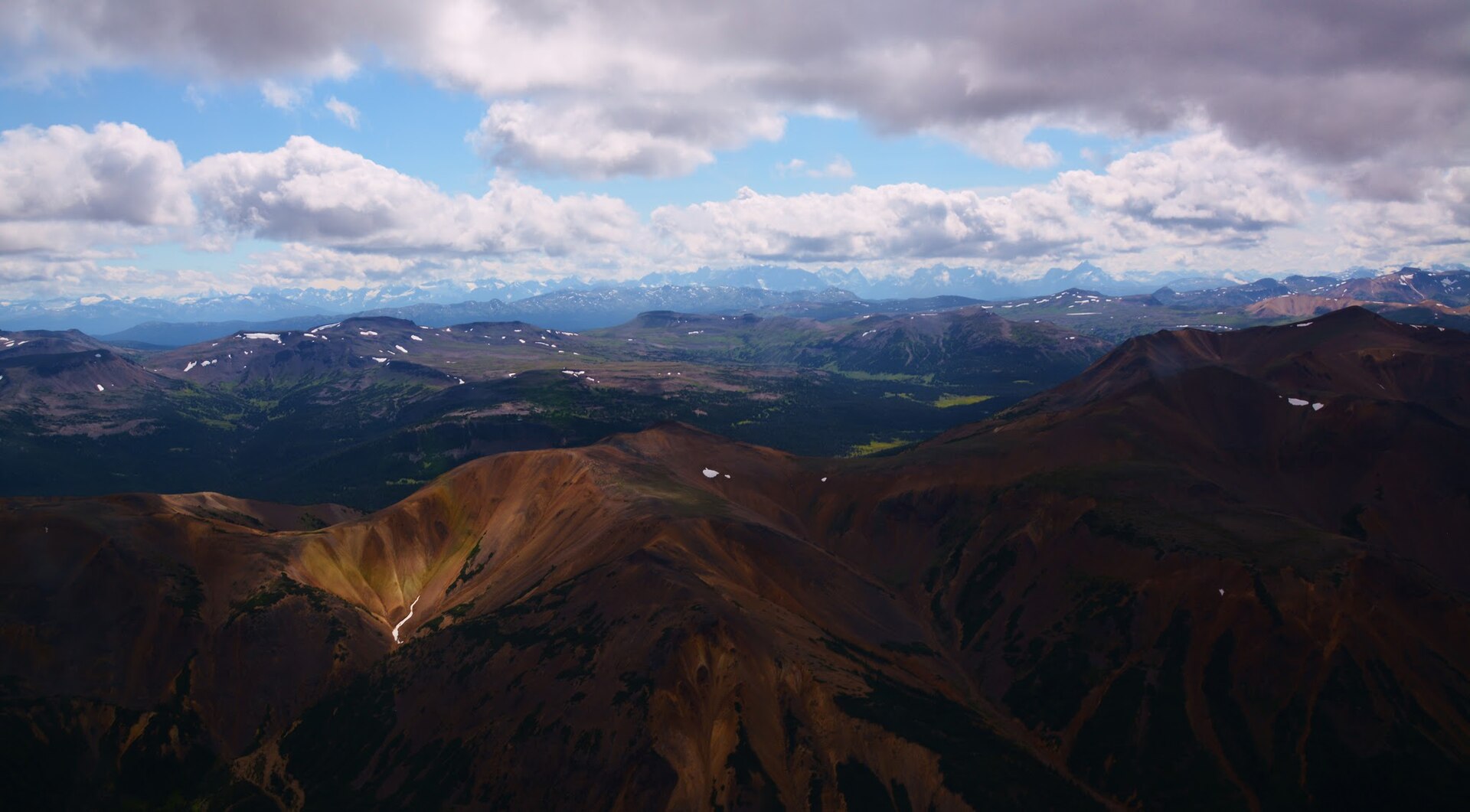
The Kitimat Ranges form the central subdivision of the Coast Mountains, bounded by the Nass River and Portland Inlet to the north, the Bella Coola River and Burke Channel to the south, and the Hazelton and Bulkley ranges to the east. Their signatures are deep glacial fjords (Douglas Channel, Gardner Canal, Dean Channel, Bentinck Arm, Kitlope), a thick blanket of coastal western hemlock and Sitka spruce rainforest climbing steep valley walls, a short subalpine band, and granitic alpine peaks rising to about 2,500–2,800 m. The eastern fringe merges into the Chilcotin Plateau and the Rainbow Range — a peralkaline shield volcano of the Anahim Volcanic Belt whose oxidised lavas paint the range in reds, oranges and yellows.
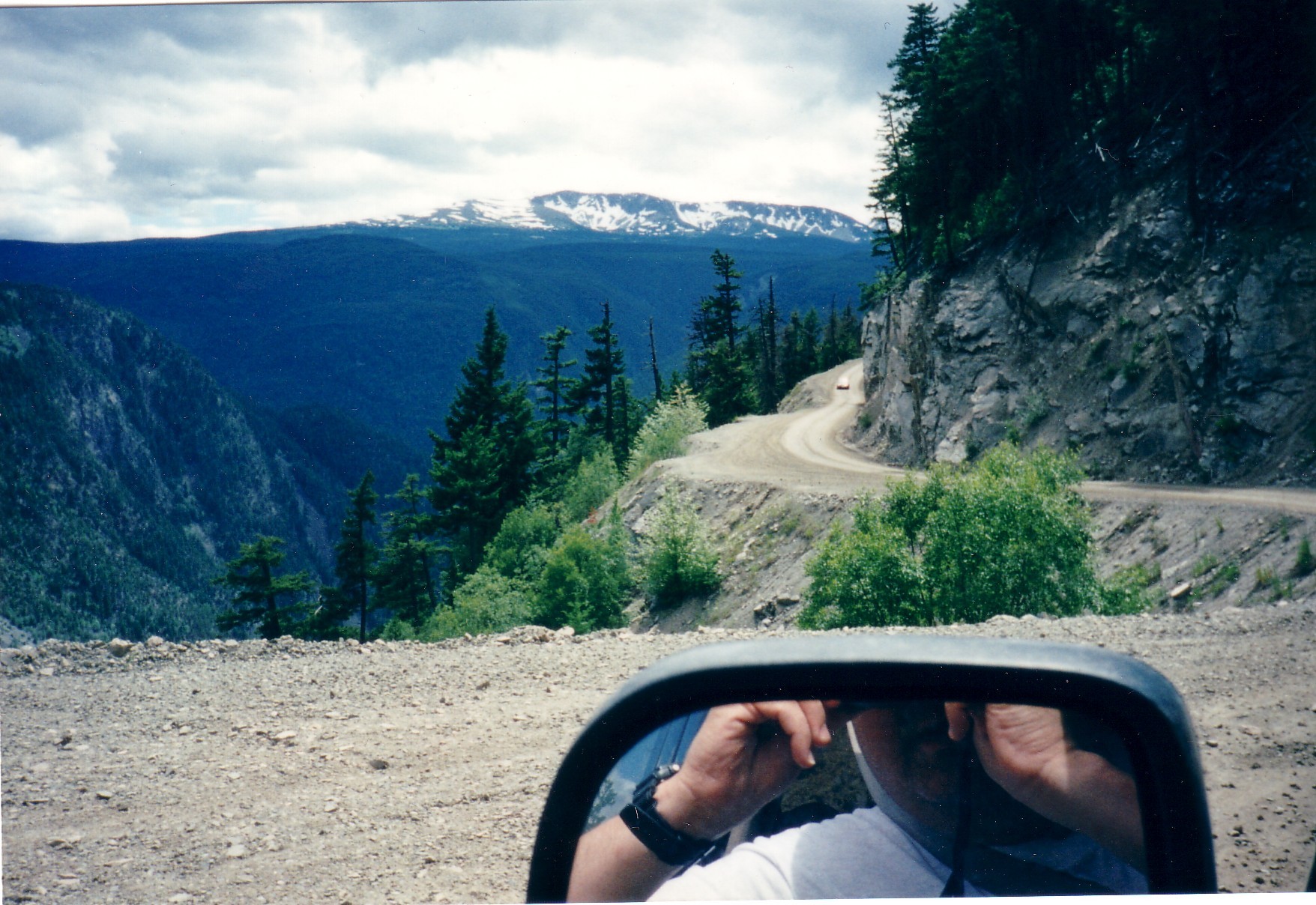
The hiking centres are few and widely spaced. Bella Coola and Hagensborg, at the head of North Bentinck Arm, anchor the southern end and provide the gateway to Tweedsmuir South Provincial Park via Highway 20. The Hill — the unpaved Heckman Pass descent on Highway 20, with grades up to 18% — is the only road across the Coast Mountains in this corridor. Kitimat and Kitamaat Village (the seat of the Haisla Nation) sit at the head of Douglas Channel and are reached by Highway 37 south from Terrace. Terrace itself, at the convention boundary with the Boundary Ranges to the north, remains the practical hub for the Sleeping Beauty, Thornhill and Copper Mountain trail networks. The Nuxalk Nation holds traditional title in the Bella Coola valley and the Atnarko–Talchako–Kitlope reaches; the Haisla hold the Douglas Channel and Kitimat–Kitlope corridor; the Kitselas (Tsimshian) hold the Skeena canyon east of Terrace.
Terrain is uncompromising. Coastal precipitation is heavy, seasonal snowpack lingers above 1,500 m well into July, and most non-paved access roads degrade quickly between maintenance cycles. Trail signage and maintenance vary widely: Tweedsmuir South trails are nominally BC Parks-maintained but are periodically grown-in after fire and beetle damage; volunteer-built Kitimat-area trails are well-cairned but unbridged and muddy after rain; the Mackenzie Heritage Trail receives only intermittent volunteer maintenance over its 420 km length. Cell coverage is non-existent on essentially every trail listed below; a satellite communicator is the practical norm.
Access: Highway 20 (“Bella Coola Highway”) runs west from Williams Lake; The Hill is gravel, narrow, single-lane in places, unsuitable for trailers but passable in standard cars in summer. Highway 37 connects Terrace to Kitimat and Kitamaat Village. BC Ferries’ Discovery Coast Connector seasonally links Port Hardy and Bella Coola in summer — confirm the current schedule before travel. Safety considerations include high grizzly density along all salmon-bearing rivers (Atnarko, Bella Coola, Dean, Kemano, Kitimat), unpredictable atmospheric-river weather, exposed alpine plateaus with no shelter, river crossings prone to spate, and limited rescue resources. Respect protocols on Nuxalk, Haisla and Kitselas territory — petroglyph and totem sites should be visited only with permission or guides.
Selection rationale
True day-hike infrastructure in this region is objectively limited: most of its famous features (Hunlen Falls, the Turner Lake Circuit, the Mackenzie Heritage Trail in full, Tweedsmuir North) are fly-in or multi-day backcountry. The five routes below cover the four physiographic settings that define the central Coast Mountains — coastal rainforest valley, volcanic alpine plateau, glaciated alpine summit and Skeena canyon — and include one explicit cultural/historical route. They draw on the three principal communities of Bella Coola/Hagensborg, Kitimat and Terrace, exclude routes that work only as multi-day expeditions, and carve out a 1-day section of the otherwise multi-week Mackenzie Heritage / Nuxalk-Carrier Grease Trail at its western terminus.
Mount Elizabeth sits at the upper edge of day-feasibility; that is noted explicitly. Hunlen Falls is excluded as a day-hike because the only day-form access is a floatplane from Nimpo Lake. Sleeping Beauty Mountain is included here on the basis of Wikipedia and PeakVisor placing the peak in the Kitimat Ranges; the companion Northern Coast Mountains entry flags the overlap.
Summary table
| # | Hike | Country | Route type | Distance | Gain | Max elevation | Difficulty |
|---|---|---|---|---|---|---|---|
| 1 | Rainbow Range Trail (Heckman Pass, Tweedsmuir South) | Canada | Out-and-back | ~14 km | ~300 m | ~1,800–1,900 m | Moderate |
| 2 | Mount Elizabeth Trail (Kitamaat Village / Kitimat) | Canada | Out-and-back | ~11–14 km (sources vary) | ~1,440–1,540 m | ~1,683–1,886 m (sources disagree) | Hard |
| 3 | Sleeping Beauty Mountain (Terrace) | Canada | Out-and-back | ~15 km return to ridge | ~950 m | ~1,500–1,650 m | Hard |
| 4 | Burnt Bridge Loop + Valley View Lookout | Canada | Loop | ~5 km | ~200 m | ~700 m | Moderate |
| 5 | Kitselas Canyon Interpretive Trail | Canada | Out-and-back | ~3 km | ~90 m | ~150 m | Easy |
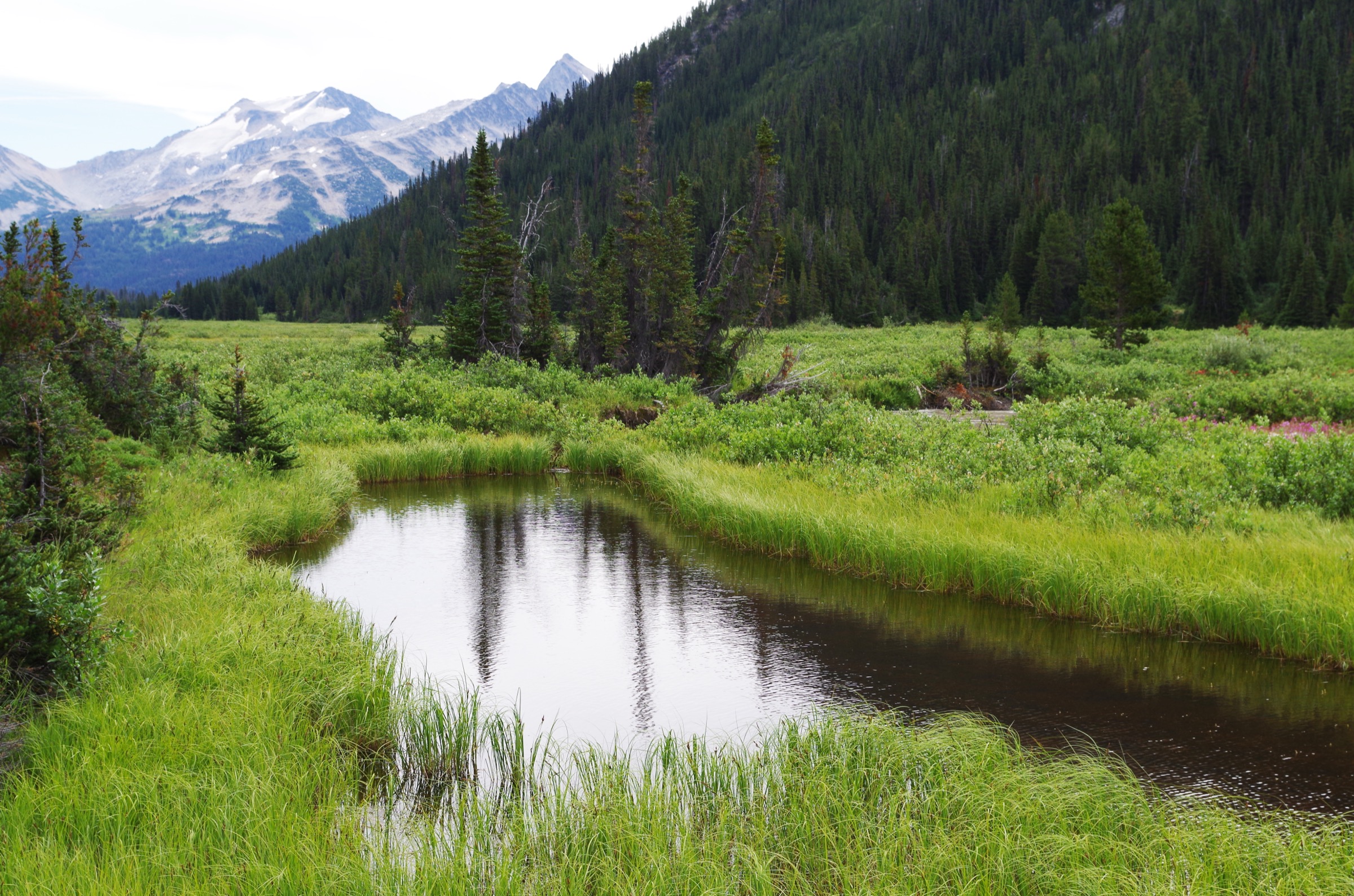
1. Rainbow Range Trail (Heckman Pass, Tweedsmuir South)
Snapshot
Itinerary
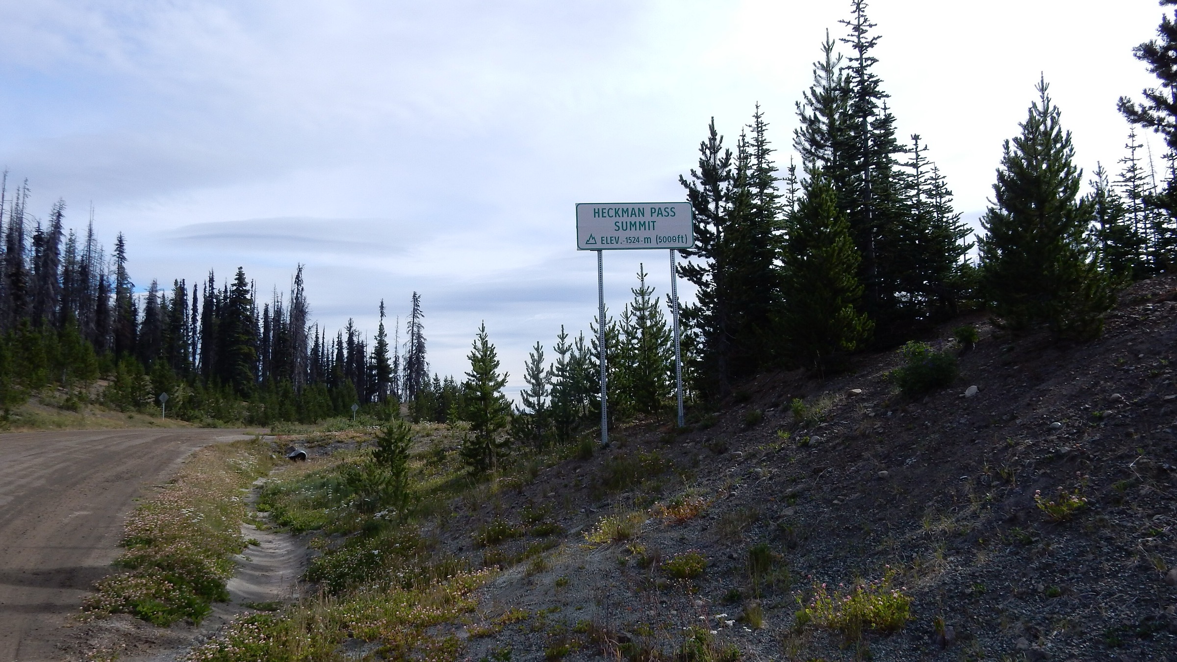
The trail leaves Highway 20 just west of the Tweedsmuir Park east boundary near the Heckman Pass summit and climbs steadily through open lodgepole pine and whitebark pine / subalpine fir forest to a small unnamed alpine lake on the edge of the Rainbow Range. The forested section is roughly the first 4–5 km; the route then breaks into rolling alpine tundra and ash-and-cinder slopes characteristic of the eroded Miocene peralkaline shield volcano. Cairns mark the trail across the alpine, and the destination is a viewpoint over the multicoloured Rainbow Range — the streaked red, orange, yellow and lavender slopes that give the range its name. The route continues west into multi-day backcountry; the day-hike turn-around is at the lake or a short way past, where the colour-banded ridges open out.
Why it is essential
The Rainbow Range is the only readily accessible peralkaline shield volcano in the Coast Mountains and one of very few in Canada that combines colour-banded volcanic terrain with broad walking alpine. The Heckman Pass day-trip is the only practical way to experience that landscape on foot without a multi-day backcountry trip or a Hunlen-type fly-in.
Equipment
- Mountain hiking equipment: layered insulation, hardshell, hat and gloves.
- Sun protection — the plateau is exposed.
- 2 L of water; alpine creeks can dry mid-season.
- Micro gaiters for ash slopes; bear spray (grizzly and black bear range; caribou and mountain goat range as well).
- Paper map, GPS or satellite communicator — no cell coverage anywhere near the route.
Hazards and notes
- Cell coverage is absent throughout. Weather changes very fast on the exposed plateau; afternoon thunderstorms occur.
- The trailhead sits at the top of The Hill — check road conditions before committing, particularly in spring and after heavy rain.
- Woodland caribou and mountain goat populations are sensitive; give space.
- Lingering snow is possible into early July.
- Do not attempt the longer onward routes (Tanya Lakes, Octopus Lake) as a day trip.
GPX / KML links
| Source | URL | Format / access | Reuse status |
|---|---|---|---|
| BC Parks: Tweedsmuir Park hiking | bcparks.ca | Official description | BC Parks website terms not evaluated; no GPX found |
| OpenStreetMap | openstreetmap.org | OSM XML / GPX export | ODbL; reusable with attribution |
| Tweedsmuir Park Lodge — Rainbow Range | tweedsmuirparklodge.com | Operator description | All rights reserved; reference only |
External links
2. Mount Elizabeth Trail (Kitamaat Village / Kitimat)
Snapshot
Itinerary
The route starts at the end of a rough 4×4 spur off the North Hirsch Mainline. Vehicles without high clearance should park at the bottom of the spur (about 2 km lower); most parties walk this approach road. The maintained trail climbs steeply through dense coastal western hemlock forest with a damp, root-laced, often muddy tread. After roughly 2–2.5 hours the trail opens out at a first viewpoint and begins to climb a heathery subalpine ridge toward Little Elizabeth (a subsidiary summit reached in approximately 3.5–4.5 hours). From Little Elizabeth the route drops slightly into a saddle then climbs the final ridge to the true summit. The summit gives broad views over Kitimat townsite, Douglas Channel, the Kitimat River valley and across the Kitimat Ranges to the Coast crest. A memorial cairn near the summit marks a 2002 fatality and underscores the weather hazard.
Why it is essential
Mount Elizabeth is the standard alpine objective above Kitimat and the most accessible 1,800-m-class summit in the central Kitimat Ranges. The Douglas Channel and Kitimat fjord view from the ridge is the iconic Haisla territorial vista, and no other day-feasible route in the Kitimat area reaches comparable elevation or exposure.
Equipment
- Mountain hiking equipment: full waterproofs (the lower forest is wet most of the season), micro gaiters, sturdy boots, trekking poles.
- Layered insulation including warm hat and gloves.
- 3 L of water; no reliable water on the upper ridge.
- High-energy food, headtorch (the descent often runs into dusk), bear spray.
- GPS or 1:50,000 map and compass; satellite communicator strongly advised. Helmet is not normally required, but the final ridge involves some hands-on scrambling.
Hazards and notes
- Weather changes very fast on the upper ridge; it is reasonable to turn at Little Elizabeth if cloud is rising.
- Cell coverage is absent above the lower valley.
- The 4×4 approach road is rough and may be impassable to standard vehicles.
- Cairns above Little Elizabeth can be difficult to follow in mist.
- The trail is on Haisla traditional territory; respect any posted protocols.
GPX / KML links
| Source | URL | Format / access | Reuse status |
|---|---|---|---|
| BC Recreation Sites and Trails — Mount Elizabeth Tr (REC0604) | sitesandtrailsbc.ca | Official trail record | No GPX confirmed; provincial terms vary |
| District of Kitimat — Trail map (PDF) | kitimat.ca | Official PDF map | Municipal terms; reference only |
| OpenStreetMap | openstreetmap.org | OSM XML / GPX export | ODbL; reusable with attribution |
External links
- BC Recreation Sites and Trails — Mount Elizabeth Tr
- District of Kitimat — Trails
- Kitimat Bound — Hiking and walking
3. Sleeping Beauty Mountain (Terrace)
Snapshot
Itinerary
From the upper parking area on Erlandsen FSR, the route follows an old section of road for approximately 1.3 km before joining the marked trail. The trail climbs steeply through second-growth hemlock, levels off, and switchbacks up through old-growth mountain hemlock and amabilis fir to a small subalpine lake with a rustic camping area. This is the end of the maintained trail and the practical day-hike turn-around. An unmarked route continues onto the ridge and, eventually, to the summit of Sleeping Beauty Mountain itself (route-finding required, alpine ridge travel with some easy scrambling). Many day parties stop at the lake or the ridge above.
Why it is essential
Sleeping Beauty is the most prominent and most popular alpine objective on the north side of the Skeena from Terrace, and the standard area introduction to subalpine and alpine hiking. The lake-and-ridge form gives a flexible day-hike turn-around: parties without alpine experience stop at the lake, while those with route-finding skills can extend to the ridge or summit.
Equipment
- Mountain hiking equipment: hardshell, mid-layer insulation, hat and gloves, sturdy boots, trekking poles.
- 2.5 L of water; bear spray.
- GPS or satellite communicator — no cell coverage.
- Map and compass for the unmarked ridge extension.
- Microspikes through mid-July in many years.
Hazards and notes
- The access road has been improved but high-clearance vehicles are still recommended.
- The trail above the lake is unmarked and route-finding-dependent; parties without experience should stop at the lake.
- Lingering snow into July; grizzly and black bear country.
- The park is small (~3 km²) and remote; no facilities.
GPX / KML links
| Source | URL | Format / access | Reuse status |
|---|---|---|---|
| BC Parks: Sleeping Beauty Mountain Park | bcparks.ca | Official description | BC Parks website terms not evaluated; no GPX found |
| OpenStreetMap | openstreetmap.org | OSM XML / GPX export | ODbL; reusable with attribution |
| Visit Terrace — Sleeping Beauty | visitterrace.com | Tourism description | All rights reserved; reference only |
External links
- BC Parks — Sleeping Beauty Mountain Park
- Visit Terrace — Sleeping Beauty Mountain
- Wikipedia — Sleeping Beauty Mountain Provincial Park
4. Burnt Bridge Loop + Valley View Lookout
Snapshot
Itinerary
The route begins at the signed parking lot on the north side of Highway 20 at the west boundary of Tweedsmuir Provincial Park. The lot also marks the western terminus of the 420 km Alexander Mackenzie / Nuxalk-Carrier Grease Trail, which finishes 4 km further at the Bella Coola estuary. A short approach (10–15 minutes) leads to the Valley View Lookout — an unrailed bluff overlooking the Bella Coola Valley to the west, with Stupendous Mountain (2,682 m) rising on the south side. The full loop continues above Burnt Bridge Creek through Douglas-fir, western redcedar and black cottonwood forest to a suspension bridge over the creek and returns down the opposite bank to the parking area. Sections of the loop coincide with the ancient Nuxalk-Carrier grease-trail network used for ooligan-oil trade between the coast and interior — the same corridor Alexander Mackenzie followed to reach the Pacific in 1793.
Why it is essential
The loop is the only short day-walk in the region that combines the iconic Bella Coola valley overlook (Stupendous Mountain and the U-shaped fjord-head valley), a representative slice of coastal Douglas-fir / cedar / cottonwood rainforest, and a culturally documented section of the Nuxalk-Carrier Grease Trail at its western terminus. It is also the most efficient way to experience a 1-day fragment of the famous Mackenzie route.
Equipment
- Standard hiking equipment: waterproof shell, waterproof footwear.
- Snacks, water, insect repellent in summer.
- Bear spray — Belarko, only a few kilometres east on Highway 20, is one of the highest-density grizzly viewing sites in BC.
- Headtorch.
Hazards and notes
- The Valley View Lookout is unrailed at the cliff edge — exercise caution with children and dogs.
- The suspension bridge is a single-cable wooden-deck design and is slick when wet or frosted.
- Bears (both species) are abundant in the Bella Coola valley, especially during the August–October salmon runs on the Atnarko / Bella Coola system.
- The route is on Nuxalk traditional territory; the broader Grease Trail corridor has cultural significance well beyond the immediate trail markings.
- Cell coverage is intermittent at best along this section of Highway 20.
GPX / KML links
| Source | URL | Format / access | Reuse status |
|---|---|---|---|
| BC Parks: Tweedsmuir Park hiking | bcparks.ca | Official description | BC Parks website terms not evaluated; no GPX found |
| Bella Coola Trails Alliance — Burnt Bridge Loop | bellacoolatrails.ca | Community description | Volunteer-managed; reference only |
| Bella Coola Valley Trail Guide (PDF) | bellacoola.ca | Official tourism PDF | Tourism Bella Coola; reference only |
| OpenStreetMap | openstreetmap.org | OSM XML / GPX export | ODbL; reusable with attribution |
External links
- BC Parks — Tweedsmuir Park hiking
- Bella Coola Forest — Burnt Bridge Loop and Valley View Lookout
- Wikipedia — Alexander Mackenzie Heritage Trail
5. Kitselas Canyon Interpretive Trail
Snapshot
Itinerary
The trail leaves the interpretive precinct (four reconstructed longhouses in the traditional Tsimshian / Kitselas style) and passes four contemporary clan poles set among towering western hemlock and Sitka spruce. Interpretive panels explain the history of the Gitselasu villages of Gitsaex (north end, east bank) and the fortified Gitlaxdzawk (“people of the ravine,” west bank promontory in the canyon) that controlled trade through this Skeena chokepoint until the 1870s. The path leads to a viewing platform over the 1.7 km north–south gorge cut by the Skeena River through the western flank of the Hazelton Mountains. Canyon walls on the east rise 20–30 m to terraces; the west side rises more steeply toward Kitselas Mountain.
Why it is essential
Kitselas Canyon is one of the most significant Indigenous archaeological and cultural landscapes on the BC north coast — designated a National Historic Site in 1972 and occupied for roughly 5,000 years. The canyon was the single most important trade chokepoint on the lower-middle Skeena and the site of two distinct fortified villages — a configuration unique on the north coast. For a region whose other day-hikes are landscape-led, Kitselas anchors the cultural slot with direct Gitselasu / Kitselas Nation interpretation.
Equipment
- Standard short-walk equipment: sturdy shoes, water, rain shell, insect repellent in summer.
- Bear spray; the lower Skeena corridor is bear country.
Hazards and notes
- The viewing platform is on the canyon rim; supervise children.
- The site is a managed cultural venue — guided tours operate seasonally; check operating hours and admission terms with the Kitselas First Nation before visiting.
- The site is on Kitselas Indian Reserve No. 1; access protocols and seasonal hours are set by the Kitselas First Nation.
- Photography of certain features may be restricted; defer to onsite signage and guides.
- CN rail tracks cross the precinct on a trestle — observe rail-corridor signage.
GPX / KML links
| Source | URL | Format / access | Reuse status |
|---|---|---|---|
| Kitselas Canyon National Historic Site | kitselascanyon.ca | Official First-Nation-operated site | No GPX confirmed |
| Kitselas First Nation | kitselas.com | First Nation source | No GPX confirmed |
| Parks Canada — Directory of Federal Heritage Designations | pc.gc.ca | Federal designation record | Reference only |
| OpenStreetMap | openstreetmap.org | OSM XML / GPX export | ODbL; reusable with attribution |
External links
- Kitselas Canyon National Historic Site
- Kitselas First Nation — Kitselas Canyon
- Parks Canada — Kitselas Canyon NHS
External links
| Source | URL |
|---|---|
| BC Parks — Tweedsmuir Park hiking | bcparks.ca |
| BC Parks — Sleeping Beauty Mountain Park | bcparks.ca |
| BC Parks — Sir Alexander Mackenzie Park | bcparks.ca |
| BC Recreation Sites and Trails — Mount Elizabeth Tr | sitesandtrailsbc.ca |
| BC Recreation Sites and Trails — Clague Mountain Trail | sitesandtrailsbc.ca |
| District of Kitimat — Trails | kitimat.ca |
| District of Kitimat — Trail map (PDF) | kitimat.ca |
| Kitimat Bound — Hiking and walking | kitimatbound.ca |
| Bella Coola Forest — Burnt Bridge Loop | bellacoolaforest.com |
| Bella Coola Trails Alliance | bellacoolatrails.ca |
| Bella Coola Valley Trail Guide (PDF) | bellacoola.ca |
| Visit Terrace — Sleeping Beauty Mountain | visitterrace.com |
| Kitselas Canyon National Historic Site | kitselascanyon.ca |
| Kitselas First Nation — Kitselas Canyon | kitselas.com |
| Wikipedia — Kitimat Ranges | en.wikipedia.org |
| Wikipedia — Rainbow Range (Chilcotin Plateau) | en.wikipedia.org |
| Wikipedia — Alexander Mackenzie Heritage Trail | en.wikipedia.org |
| Wikipedia — Kitselas Canyon | en.wikipedia.org |