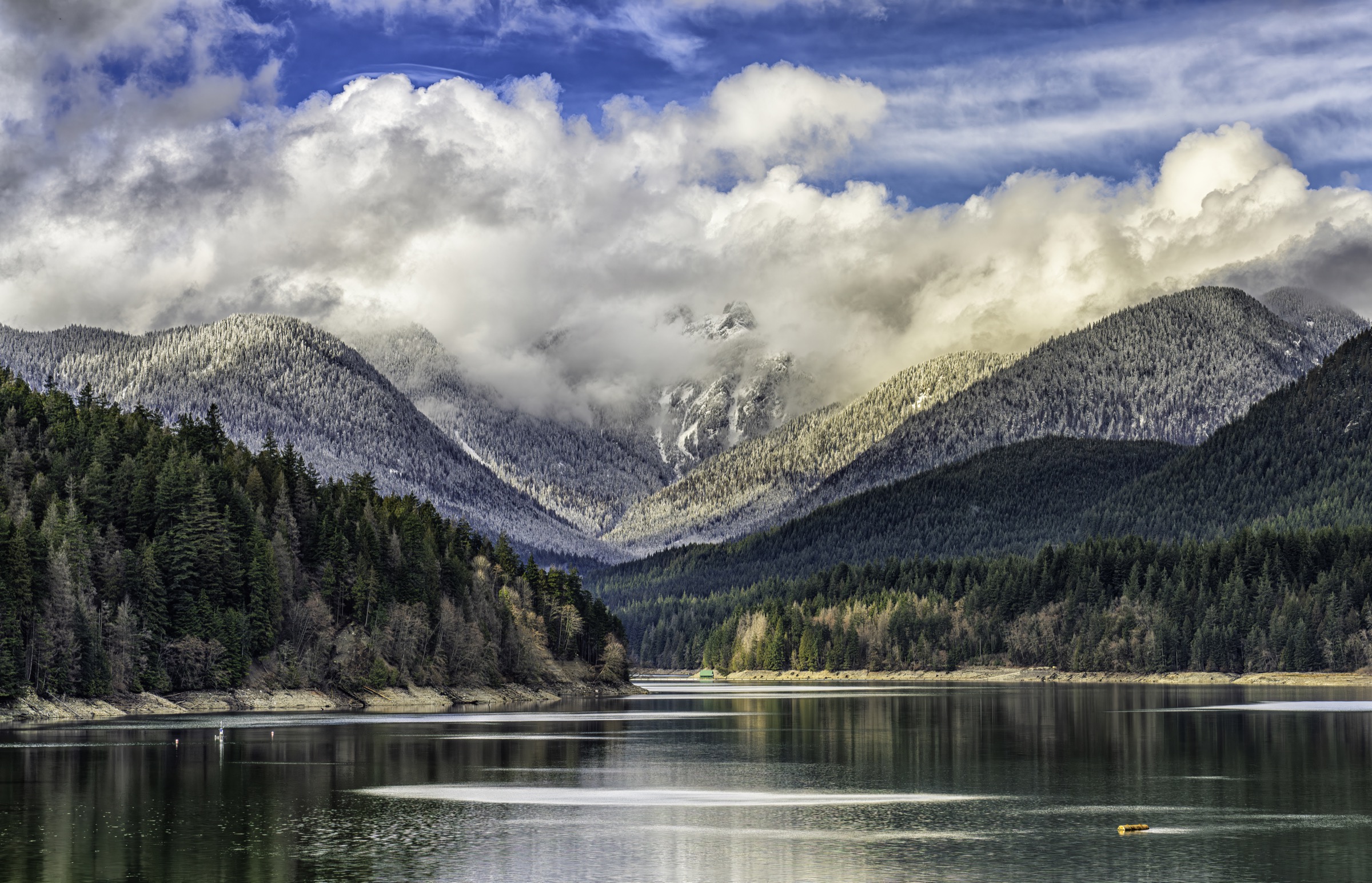
Regional overview
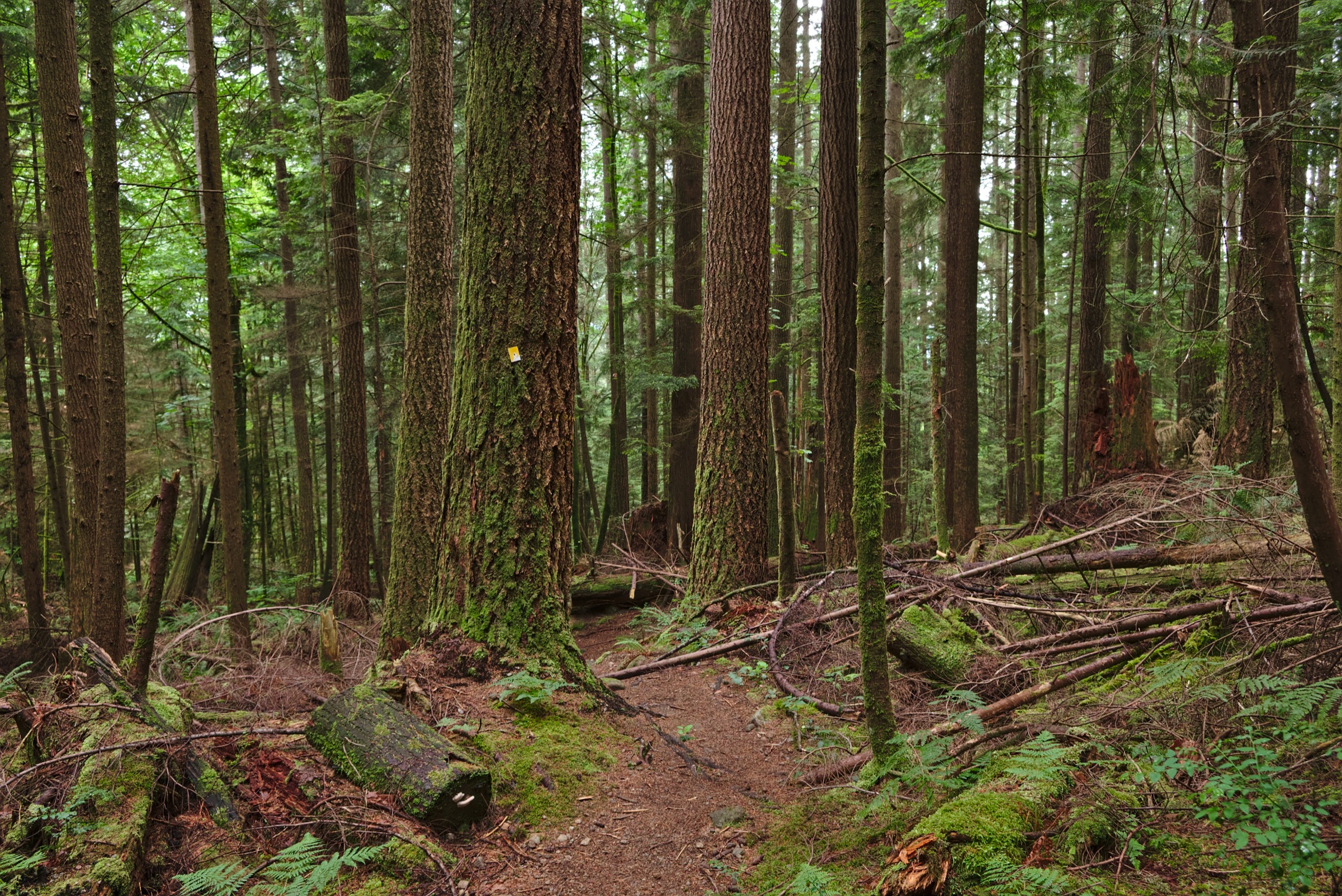
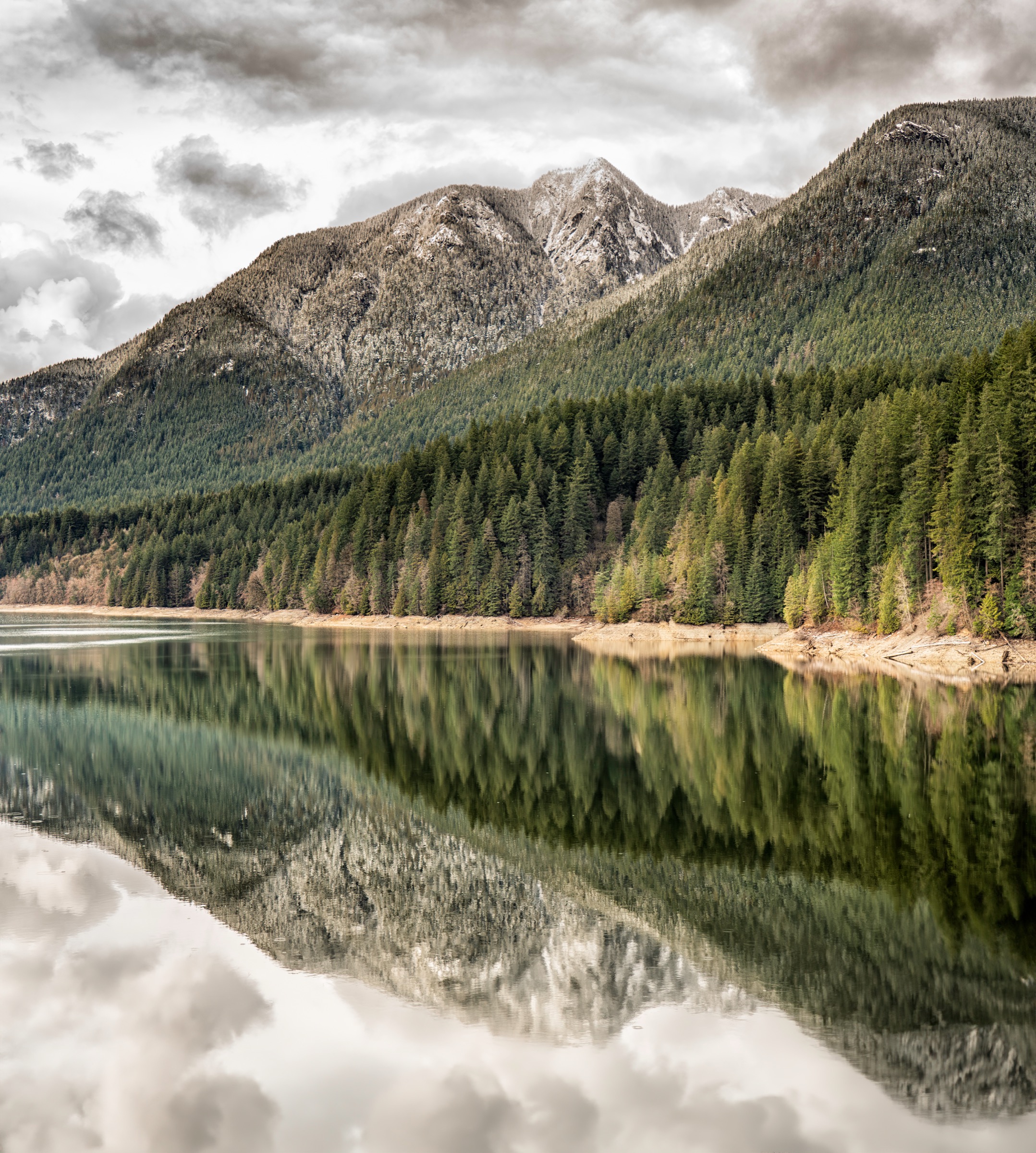
The North Shore Mountains rise abruptly from the saltwater of Burrard Inlet and Howe Sound, forming the immediate backdrop to Vancouver. They sit on the eastern edge of the Coast Mountains’ Pacific Ranges. Below roughly 1,000 m the slopes are clothed in dense coastal western hemlock rainforest of Douglas-fir, western hemlock, western redcedar and amabilis fir, with deeply incised creeks (Capilano, Lynn, Seymour) carved into glacially-scoured granitic and dioritic bedrock. Above the treeline a narrow subalpine belt of mountain hemlock and yellow-cedar gives way to small heather meadows, granite bluffs and the bare summits of peaks between 1,200 m and 1,700 m.
Four hiking nodes dominate. From west to east these are Cypress Provincial Park (Black Mountain, Hollyburn Mountain, Mt Strachan, and access to the Howe Sound Crest Trail leading to the Lions), the Grouse area (Grouse Grind, BCMC, Dam Mountain, Goat Mountain, Crown Mountain), the Lynn Headwaters / Lower Seymour Conservation Reserve corridor (Lynn Peak, Coliseum, Mt Burwell), and Mount Seymour Provincial Park (Pump Peak, Tim Jones Peak, Mt Seymour summit, Mt Elsay, Mt Bishop). Cypress and Mt Seymour are BC Parks; Lynn Headwaters is a Metro Vancouver regional park; Grouse Mountain is a private resort whose Skyride and trail network adjoin BC Mountains Recreation Area land.
Season is bimodal. Forested low-elevation routes (Lynn Loop, Baden-Powell sections, Grouse Grind) are essentially year-round. Alpine routes are reliably snow-free only from late June or early July through to October. Snow lingers in the north-facing gullies of Mt Seymour, Crown Mountain and the Lions well into July, and avalanche terrain exists on the Howe Sound Crest Trail, Crown Pass and the north side of Mt Seymour from November to May.
Access is overwhelmingly car-based. Cypress Provincial Park has no scheduled summer transit and is reached by car or seasonal private shuttles. Mt Seymour requires a free BC Parks day-use vehicle pass on winter weekends and holidays (12 Dec 2025 – 29 March 2026 in the current season, daily until 4 Jan 2026 then weekends/holidays only). Grouse Mountain is reachable by TransLink bus #236 from Lonsdale Quay. Lynn Headwaters has bus #228. Lions Bay is accessed by car via the Sea-to-Sky Highway with strict, enforced pay parking on Sunset Drive ($3/hr, $24/day; fines around $195 and towing to North Vancouver). North Shore Rescue is one of North America’s busiest volunteer SAR teams, recording 226 callouts in its peak pandemic year (2021) and 158 in 2023; sudden marine cloud, glaze ice on granite slabs, off-trail bluffs and route-finding failures in cloud are recurring incident patterns.
Selection rationale
Five hikes were chosen to represent the geographic range and character types of the North Shore. Mt Seymour to Pump Peak is the iconic, family-grade subalpine summit reached from a high trailhead in a BC Park. Hollyburn Mountain is the classic Cypress Park subalpine summit. The Lions via Binkert Trail is the culturally iconic objective: the twin peaks visible from every street in central Vancouver, named in the Squamish language (Ch’ich’iyúy Elxwíkn) and on the Lions Gate Bridge, included as a strenuous ridge hike with the West Lion summit block flagged explicitly as scrambling. Lynn Peak is the representative forest-to-ridge balcony route from a low (sea-level) trailhead inside a Metro Vancouver regional park. Crown Mountain is the technical North Shore summit: a long, exposed scramble from the Grouse gondola and the most frequent source of NSR callouts among the named peaks.
Summary table
| # | Hike | Sub-region | Route type | Distance | Gain | Max elevation | Difficulty |
|---|---|---|---|---|---|---|---|
| 1 | Mt Seymour to Pump Peak (with optional Tim Jones / Mt Seymour summit) | Mt Seymour Provincial Park | Out-and-back | 7–9 km | 450–550 m | 1,449 m | Moderate (summit traverse: difficult) |
| 2 | Hollyburn Mountain | Cypress Provincial Park | Out-and-back | 7–8 km | 400–450 m | 1,326 m | Moderate |
| 3 | The Lions via Binkert Trail | Lions Bay / Cypress Provincial Park | Out-and-back | 15–16 km | ~1,280 m | ~1,525 m at col (1,654 m if scrambling West Lion) | Difficult; summit block class 3–4 scramble |
| 4 | Lynn Peak (to lookout) | Lynn Headwaters Regional Park | Out-and-back | 8–9 km | ~720 m | ~921 m | Moderate–difficult |
| 5 | Crown Mountain (from Grouse Skyride) | Grouse Mountain / North Shore Recreation Area | Out-and-back | ~10 km | ~800 m cumulative | 1,504 m | Difficult; exposed summit scramble |
1. Mt Seymour to Pump Peak
Snapshot
Itinerary
The trail leaves the north end of the upper ski-area lot at about 1,000 m and climbs through subalpine mountain hemlock under the chairlifts. After about 1 km a junction marks Dinkey Peak, a short worthwhile detour. The route then traverses below Brockton Point and emerges onto open granite slabs marked with orange paint. A series of short rocky rises lead to Pump Peak (First Peak) at roughly 1,400 m, with open views across Indian Arm, downtown Vancouver and the Strait of Georgia. Most parties turn here.
To continue, drop into the col north of Pump Peak on a steep, rooted track, then climb directly to Tim Jones Peak (Second Peak, 1,425 m, renamed in 2017 for the North Shore Rescue leader who died on the mountain in 2014). A second, deeper col with short rocky steps and exposure leads to the true Mt Seymour summit (Third Peak, 1,449 m). Return follows the same route — there is no through-route to the resort base.
Why it is essential
Pump Peak is the most-walked alpine summit on the North Shore and the standard introduction to BC Coast Mountain ridge hiking. The high trailhead means significant alpine views are reached with modest gain.
Equipment
- Sturdy boots with good edging on granite.
- Layered shell and warm mid-layer; the summit is regularly 10 °C colder and 30 km/h windier than the parking lot.
- 2 L water.
- Paper map and offline GPS — cloud forms quickly on the ridge.
- Headlamp.
- Microspikes and snowshoes November through May; avalanche transceiver, probe and shovel for off-piste winter travel.
Hazards and notes
- The cols between Pump, Tim Jones and the true summit are the most-frequent NSR callout location on the mountain. Parties routinely lose the painted route in cloud and descend the wrong drainage into Suicide Gully (avalanche terrain, no exit).
- Stay on the marked trail and turn around in whiteout.
- Dogs permitted on leash. Toilets at the lower lot. No reliable cell coverage past Brockton Point.
GPX / KML links
| Source | URL | Format / access | Reuse status |
|---|---|---|---|
| OpenStreetMap | openstreetmap.org | OSM ways (export to GPX) | ODbL 1.0; relation not directly located in this pass |
| Vancouver Trails — Mount Seymour | vancouvertrails.com | Embedded map | Site terms; not freely redistributable |
| AllTrails — Pump Peak | alltrails.com | GPX (AllTrails Plus) | Site terms; not freely redistributable |
External links
- BC Parks — Mount Seymour Park: Hiking
- BC Gov News — 2025-26 winter day-use pass
- Vancouver Trails — Mount Seymour
- North Shore Rescue
2. Hollyburn Mountain
Snapshot
Itinerary
From the Nordic parking lot at roughly 920 m, the route passes the BC Parks information kiosk onto the powerline service road. After roughly 400 m it intersects the Baden-Powell Trail near Fourth Lake. The signed Hollyburn Peak trail bears uphill. The path climbs steadily through old-growth yellow-cedar and mountain hemlock with intermittent boardwalks across boggy meadows. Two small tarns (Triangle and West lakes) sit just east of the line. The grade steepens in the final 800 m as the trail emerges from forest into berry-rich heather meadows. A short rocky scramble of perhaps 10 m delivers the summit knoll at 1,326 m, with a panorama that spans the Strait of Georgia, the Gulf Islands, Vancouver Island’s mountains, the Lions to the northwest, Crown and Grouse to the east, and Mt Baker in Washington on a clear day. Return is by the same trail.
Why it is essential
Hollyburn is the archetypal Cypress Park subalpine summit. It packs the full character of the Coast Mountains’ eastern fringe — cedar bog, lake-dotted meadow, granite ridge — into a half-day from a paved trailhead, and offers the closest unobstructed view of the Lions accessible without scrambling.
Equipment
- Boots with grip for rooted, wet sections.
- Light shell and warm mid-layer.
- Insect repellent in July.
- 1.5 L water.
- Headlamp.
- Snowshoes and a transceiver-probe-shovel kit for winter.
Hazards and notes
- Hollyburn Ridge has a long history of winter SAR callouts; the trail is unmarked under snow, and the slope onto the lakes is committing terrain in poor visibility.
- Backcountry skiers regularly trigger small slides on the steeper southwest face in spring — stay on marked routes.
- Limited parking; arrive before 09:00 on summer weekends.
- Dogs on leash. Washrooms at the Nordic lodge. No camping in the park.
GPX / KML links
| Source | URL | Format / access | Reuse status |
|---|---|---|---|
| OpenStreetMap | openstreetmap.org | OSM ways | ODbL 1.0; specific way IDs not extracted in this pass |
| Vancouver Trails — Hollyburn Mountain | vancouvertrails.com | Embedded map | Site terms; not freely redistributable |
External links
- BC Parks — Cypress Park hiking and skiing
- Vancouver Trails — Hollyburn Mountain
- Friends of Cypress Provincial Park
- Hollyburn Heritage Society
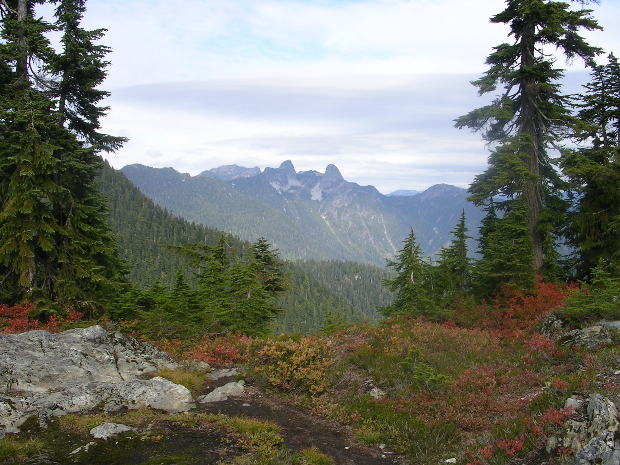
3. The Lions via Binkert Trail
Snapshot
Itinerary
The route begins at the yellow gate at the top of Sunset Drive, roughly 200 m above sea level. The first 5 km follow a steady, exposed gravel access road switchbacking through second-growth Douglas-fir and western redcedar; the road crosses Harvey Creek with a waterfall view. Where the road ends, the singletrack Binkert Trail begins. The trail steepens through hemlock, breaks above 1,300 m onto small heather benches, and traverses a boulder field beneath the south face of West Lion. A short gully scramble leads to the col between the two Lions at roughly 1,525 m, where the route ends for hikers; sightlines open to both Lion summits, the Howe Sound Crest Trail to the north, and Howe Sound to the west.
Continuing to the West Lion summit (1,654 m) involves class 3–4 scrambling on exposed rock with route-finding decisions and falling consequences — this is the territory of experienced scramblers only, not hikers. The East Lion (1,606 m) lies within the Greater Vancouver watershed and is closed to public access. Return is by the same route.
Why it is essential
The Lions are the cultural symbol of Vancouver — named for the Squamish reference to twin sisters (Ch’ich’iyúy Elxwíkn), depicted on the Lions Gate Bridge, the BC Lions and Lionsgate Entertainment. Reaching the col at their base from sea level is one of the defining strenuous day-hikes of the BC south coast and the standard way to stand among the peaks legally without technical climbing.
Equipment
- Stiff boots with good edging.
- 3 L water — creeks dry by August.
- Poles for the descent.
- Helmet for any party attempting the West Lion scramble.
- Map and compass plus offline GPS.
- Emergency shelter and headlamp — many parties underestimate this hike’s time and finish in the dark.
Hazards and notes
- The West Lion summit block is a class 3–4 scramble with fatal-fall exposure and should not be attempted by hikers without scrambling experience.
- Verglas can persist on the upper rock into July.
- The boulder field below the col holds snow and is a chronic site of slip injuries.
- NSR is regularly called to this route; cell coverage is poor above the access road.
- Dogs permitted but discouraged above the boulder field. No camping at the col.
GPX / KML links
| Source | URL | Format / access | Reuse status |
|---|---|---|---|
| OpenStreetMap (Binkert Trail and connector to Howe Sound Crest) | openstreetmap.org | OSM ways | ODbL 1.0; reusable with attribution |
| Trailforks — The Lions (Binkert Trail) | trailforks.com | Embedded; user GPX export | Trailforks terms; not openly licensed |
| Howe Sound Crest Trail map (BC Parks PDF) | nrs.objectstore.gov.bc.ca | PDF only | Crown copyright, BC; reference only |
External links
- Vancouver Trails — The Lions Binkert Trail
- Wikipedia — The Lions (peaks)
- Village of Lions Bay — Parking
- 10Adventures — The Lions via Binkert Trail
4. Lynn Peak
Snapshot
Itinerary
Cross the Lynn Creek suspension bridge from the parking area and turn right along the wide gravel Lynn Loop Trail. After about 1 km a signed junction sends the Lynn Peak Trail steeply uphill to the east. The route climbs continuously through mossy second-growth Douglas-fir and western hemlock with occasional veterans of original-growth cedar. Three named viewpoints — Enzbrenner Bench (a memorial), the South Lookout, and the main viewpoint — punctuate the climb. The main lookout at roughly 921 m offers a broad view across the Seymour Valley to Mt Seymour, the Strait of Georgia and on clear days the Olympic Peninsula. Continuing north along the rolling ridge for another 1.5 km reaches the true summit, which is treed with limited views — most parties turn at the lookout. Return is by the same route, or via Lynn Loop for a slightly varied finish.
Why it is essential
Lynn Peak is the representative low-trailhead North Shore “balcony” hike — a sea-level start in a Metro Vancouver regional park, sustained gradient through coastal rainforest, and an honest view of the next ridge over. It is the year-round option in this set: snow-free far longer than Mt Seymour or the Lions.
Equipment
- Trail-running shoes or light boots.
- 2 L water — no reliable water on the climb.
- Trekking poles for the descent.
- Headlamp on shorter days.
- Microspikes from November through March.
- Bear spray reasonable — Lynn Headwaters has black bear activity.
Hazards and notes
- Steep rooted rock is slippery when wet; slip-and-fall injuries are common, and the descent is harder on the knees than the climb.
- Cougars and black bears use the lower forest.
- Dogs on leash. No camping.
- Park gates close at dusk — vehicles left inside are locked in.
- Cell coverage is reliable on the lower trail and at the lookout (line-of-sight to downtown).
GPX / KML links
| Source | URL | Format / access | Reuse status |
|---|---|---|---|
| OpenStreetMap (Lynn Peak Trail) | openstreetmap.org | OSM ways | ODbL 1.0; reusable with attribution |
| Metro Vancouver Lynn Headwaters trail map (PDF) | metrovancouver.org | Crown / Metro Vancouver; reference only |
External links
- Vancouver Trails — Lynn Peak
- Outdoor Vancouver — Lynn Peak
- Best Hikes BC — Lynn Peak
- Metro Vancouver — Lynn Headwaters Regional Park
5. Crown Mountain
Snapshot
Itinerary
From the Grouse chalet, the Alpine Trail leads past the wind turbine and chairlift base. The track climbs to Dam Mountain, traverses Little Goat and skirts the south flank of Goat Mountain. After about 2.5 km the route splits — bear left at the Crown Mountain sign. The trail then drops steeply into Crown Pass on rooty switchbacks and a short fixed-chain section, losing roughly 200 m of hard-won elevation. From the pass the climb to Crown is direct and steep, with two boulder fields and a short ridge approach. The final 30 m is an exposed scramble on cracked granite with a small step-across move at the top — the summit cairn sits on a rounded block above several hundred metres of fall potential on multiple sides. Many parties reach the false summit just below and turn back. Return is by the same route; the climb out of Crown Pass back to Grouse is the crux of the return leg.
Why it is essential
Crown is the technical North Shore summit, the natural extension of the Goat Mountain ridge and the highest peak readily reached from a public lift. It is included as the catalogue’s representative scrambling objective: a serious day with route-finding, exposure and stamina demands rarely combined elsewhere in Metro Vancouver.
Equipment
- Stiff boots with good edging.
- Helmet for the summit block.
- 3 L water.
- Gloves for the chains in Crown Pass.
- Map, compass and offline GPS.
- Headlamp.
- Spare layers — Crown holds wind.
- Microspikes useful into early July for the north-facing snow patches.
Hazards and notes
- NSR is repeatedly called to Crown Mountain; the most common failure modes are exhaustion on the climb out of Crown Pass, summit-block falls, and benightment on the descent in fog.
- Time the day to be off the summit by mid-afternoon and below Crown Pass before sunset.
- The last Skyride down is at a fixed time — check the day’s schedule with Grouse Mountain Resort and plan to descend the BCMC Trail (3 km, ~800 m) if missed.
- Dogs strongly discouraged because of the chains and summit scramble. No camping.
- Cell coverage drops off in Crown Pass.
GPX / KML links
| Source | URL | Format / access | Reuse status |
|---|---|---|---|
| OpenStreetMap (Crown Mountain Trail; Alpine Trail) | openstreetmap.org | OSM ways | ODbL 1.0; reusable with attribution |
| Vancouver Trails — Crown Mountain | vancouvertrails.com | Site map (embedded) | Site terms; not openly licensed |
| AllTrails — Crown Mountain | alltrails.com | AllTrails Plus GPX | Site terms; not openly redistributable |
External links
- Vancouver Trails — Crown Mountain
- Outdoor Vancouver — Crown Mountain
- Best Hikes BC — Crown Mountain
- Grouse Mountain Resort — Alpine trails and Skyride schedule
Missing data / follow-up work
- No licence-compatible photo of the Lynn Peak lookout view was located in this pass. A dedicated Flickr CC search and a Wikimedia Commons category check for
Lynn Peak(separate from the broader Lynn Headwaters category) should be repeated. - The Hollyburn Mountain trail image used here is 2,048 × 1,536 px — below the 2,400 px long-edge preference. A higher-resolution Hollyburn summit image was not identified.
- A separate high-resolution summit-perspective image of the Lions (distinct from the Capilano Lake cover view) was not identified at a usable resolution; the Andrew Plowright “The Lions summits” image on Commons is only 1,200 × 443 px.
- Specific OSM relation IDs for each trail (Pump Peak spur, Hollyburn Peak Trail, Binkert Trail, Lynn Peak Trail, Crown Mountain Trail) were not retrieved in this pass — the Baden-Powell Trail relation ID is 936034. A follow-up Overpass query (e.g.
name=~"Binkert") is required to produce reusable GPX exports. - The current 2026 status of Lions Bay’s resident-shuttle and Cypress summer transit proposals should be re-verified before publication.
- The true summit of Lynn Peak and the Mount Seymour summit traverse beyond Tim Jones Peak were verified by description only; on-the-ground verification of route condition (chains, fixed lines) post-2024 is recommended.
- Coliseum Mountain (long, lower-traffic, classic Hanes Valley return) deserves consideration as a sixth catalogue entry to round out the eastern Lynn Headwaters / LSCR sub-region.
External links
| Source | URL |
|---|---|
| BC Parks — Mount Seymour Park | bcparks.ca |
| BC Parks — Mount Seymour: Hiking | bcparks.ca |
| BC Parks — Cypress Park | bcparks.ca |
| BC Parks — Cypress Park: Hike / Ski | bcparks.ca |
| BC Parks — Day-use passes | bcparks.ca |
| BC Gov News — 2025-26 winter day-use pass | news.gov.bc.ca |
| Metro Vancouver — Lynn Headwaters Regional Park | metrovancouver.org |
| Village of Lions Bay — Parking | lionsbay.ca |
| North Shore Rescue | northshorerescue.com |
| North Shore News — 2023 NSR call data | nsnews.com |
| Vancouver Trails | vancouvertrails.com |
| Outdoor Vancouver | outdoorvancouver.ca |
| Best Hikes BC | besthikesbc.ca |
| Grouse Mountain Resort | grousemountain.com |