Regional overview
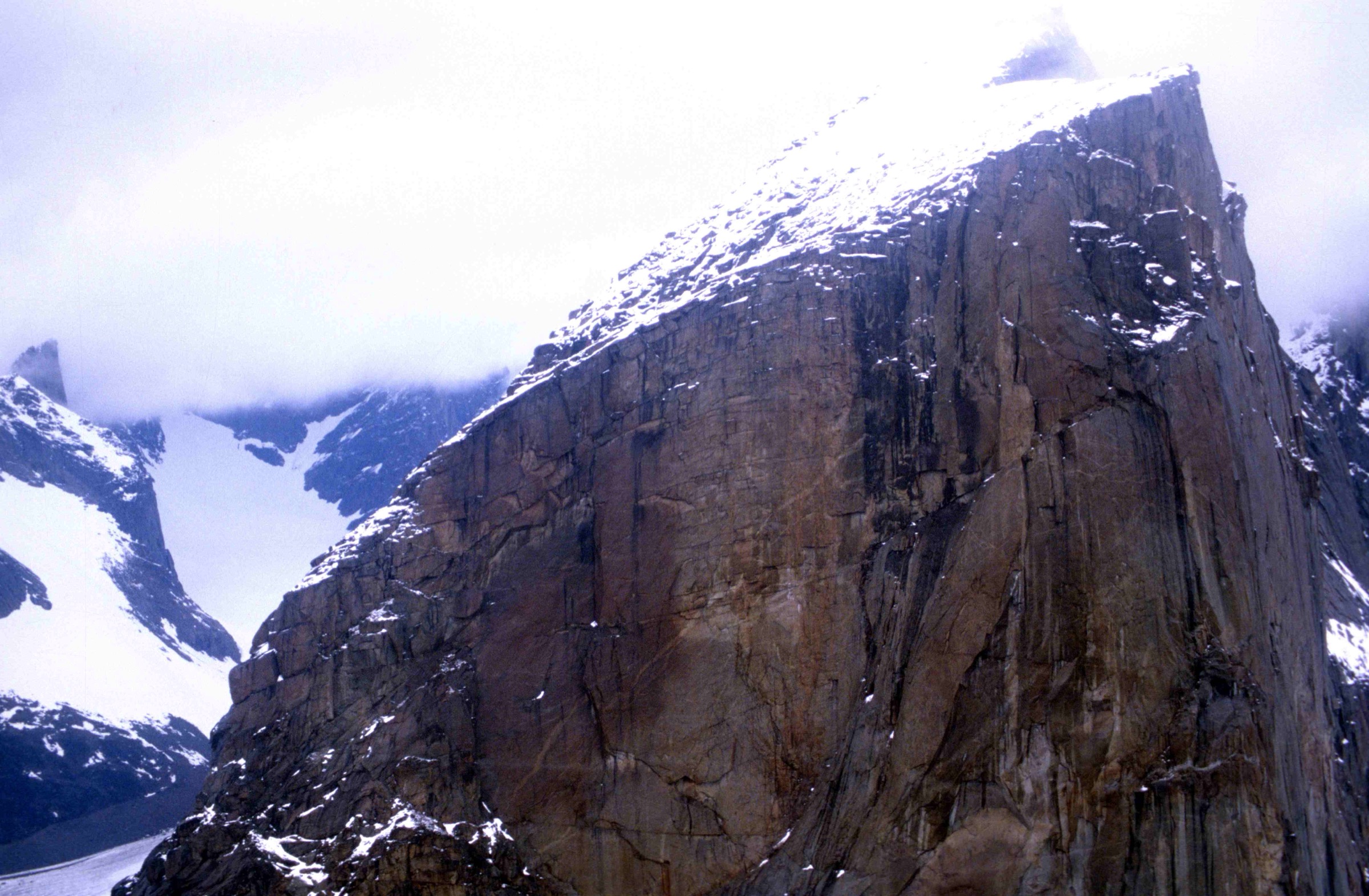
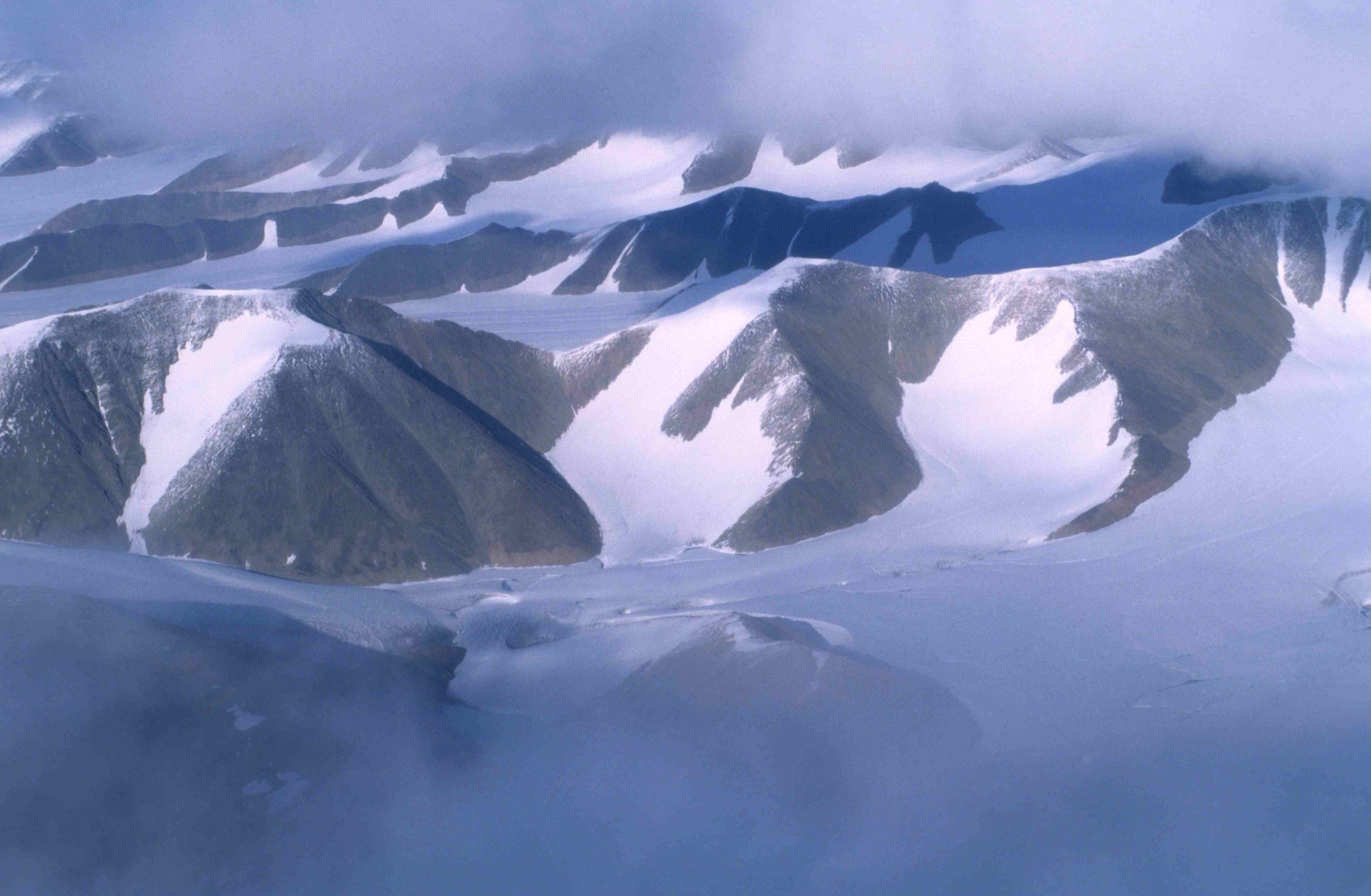
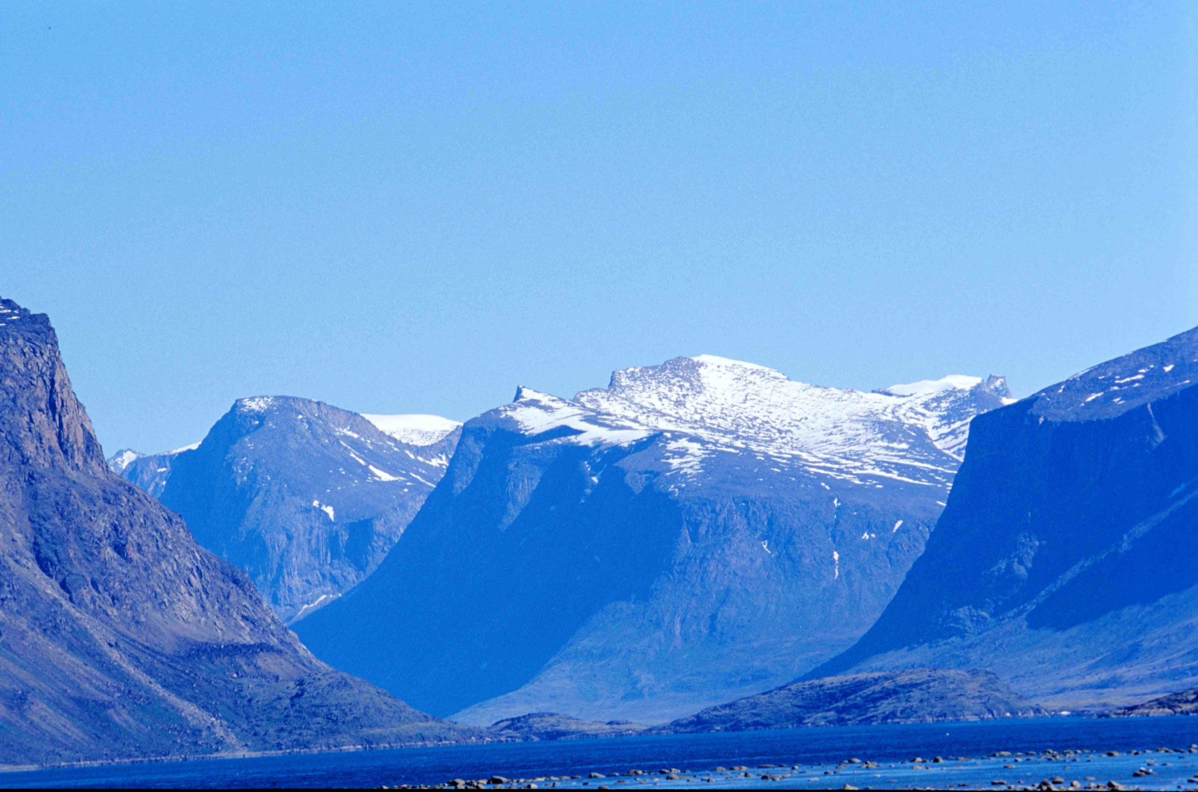
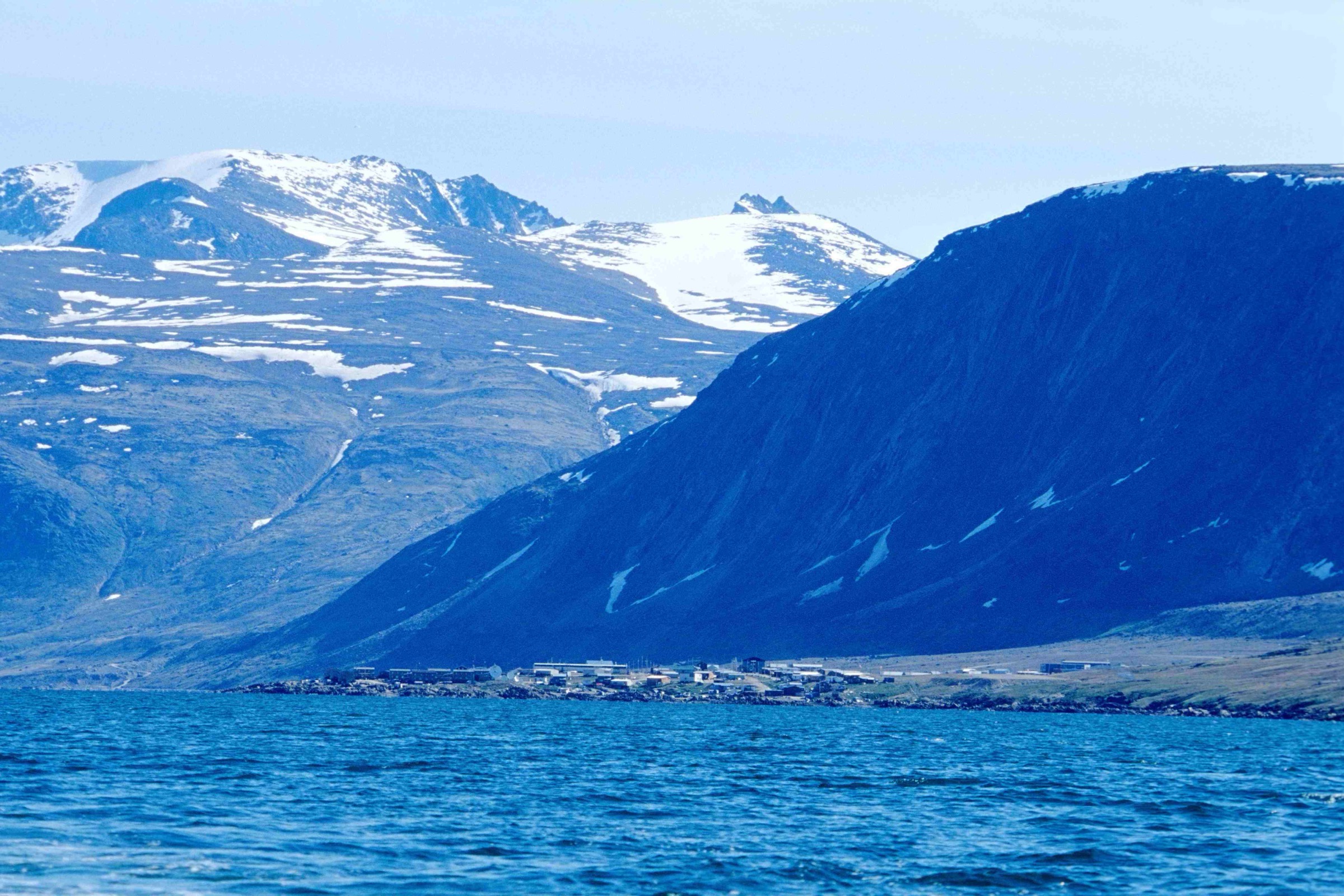
The Cumberland Peninsula forms the eastern arm of Baffin Island in Nunavut, bounded by Cumberland Sound to the south, Davis Strait to the east, and a wide saddle of land linking it to the rest of Baffin Island to the west. Its core is the Penny Ice Cap, around which deep glacially carved fjords — Pangnirtung Fiord, Kingnait Fiord, North Pangnirtung Fiord, Padle Fiord and Maktak Fiord — cut down to the coast, separating the granite peaks of the Baffin Mountains. Inside Auyuittuq National Park these culminate at Mount Odin (2,143 m) and the great walls of Mount Asgard and Mount Thor.
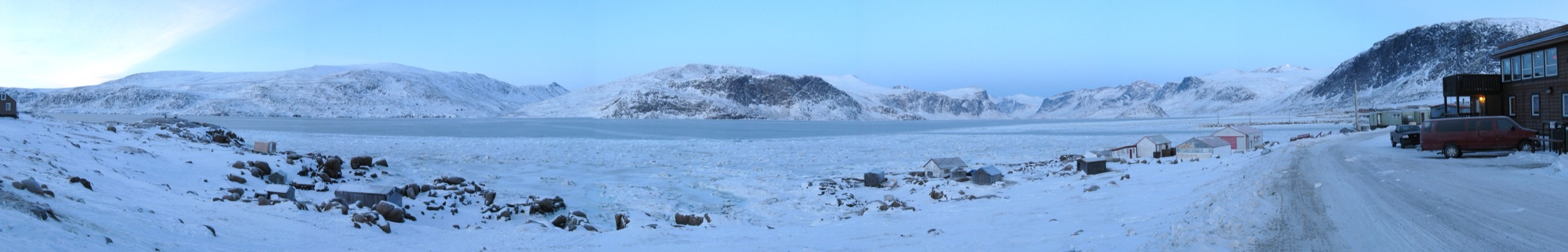
Two Inuit hamlets sit at the foot of this landscape: Pangnirtung at the head of Pangnirtung Fiord on the south coast, and Qikiqtarjuaq on Broughton Island on the east coast. Neither is connected to a road network: access is by fixed-wing aircraft only, via Iqaluit. Established day-walking is sparse. The peninsula is best known for the multi-day Akshayuk Pass traverse through Auyuittuq, which is treated as a separate region. From the settlements themselves, the only widely documented summit walk is Mount Duval above Pangnirtung. Parks Canada and the Hamlet of Pangnirtung otherwise package the day options as guided trips combining a boat or snowmobile transfer with a short walk — to Ulu Peak, to the Arctic Circle marker at the southern end of Akshayuk Pass, or to the historic whaling station at Qikiqtan (Kekerten) Territorial Park.
The walking season is short. Snow-free ground is normally only feasible from late June to mid-August, and even then sudden snow, sub-zero overnight temperatures and katabatic winds off the Penny Ice Cap are routine. Unbridged fjord-side streams swollen by afternoon glacier discharge can become impassable. Polar bears are present anywhere away from the immediate settlement footprint — on the open tundra, along the coast and on sea ice early and late in the season. Local advice strongly favours travelling with a registered Inuit guide outside the village edges, carrying a bear deterrent, and renting a satellite communicator: no cell coverage exists beyond the hamlets. All travel into Auyuittuq requires registration, a pre-departure orientation and a permit at the Parks Canada office in Pangnirtung or Qikiqtarjuaq; Kekerten visits are normally arranged through licensed local outfitters because of the three-hour boat passage from Pangnirtung.
International English spelling is used throughout. The spelling “Pangnirtung Fiord” follows Canadian government usage; “Fiord” and “Fjord” appear interchangeably in sources.
Selection rationale
The five hikes below are the most defensible day options on the Cumberland Peninsula outside the main multi-day Akshayuk Pass corridor. Mount Duval is the single well-documented walk from a settlement and the only Cumberland Peninsula route with a genuine reputation as a must-do day hike. The Pisuktinu Tunngavik shoreline and ridge walk is the practical short option from the hamlet itself. Ulu Peak and the Arctic Circle / Crater Lake trips are Parks Canada-led guided days at the southern fringe of Auyuittuq from Pangnirtung — both are short walks tied to a boat or snowmobile transfer and they are explicitly the day-trip offerings advertised by the park. The Qikiqtan (Kekerten) interpretive trail is the only formally signed walking trail on the peninsula outside Auyuittuq and provides the cultural and historical day. Two of the five sit at the very edge of Auyuittuq and are short walks within longer guided days; the main Akshayuk Pass coverage belongs in a separate entry.
Summary table
| # | Hike | Country | Route type | Distance | Gain | Max elevation | Difficulty |
|---|---|---|---|---|---|---|---|
| 1 | Mount Duval from Pangnirtung | Canada | Out-and-back | ~8-10 km | ~830-870 m | ~850 m | Strenuous |
| 2 | Pisuktinu Tunngavik shoreline and ridge | Canada | Loop / out-and-back | ~3-5 km | ~80-150 m | ~150 m | Easy-Moderate |
| 3 | Ulu Peak day trip from Pangnirtung | Canada | Out-and-back (boat-assisted) | ~6-10 km on foot | up to ~400 m | ~400 m | Moderate (guided) |
| 4 | Arctic Circle and Crater Lake from Overlord | Canada | Out-and-back (boat- or snowmobile-assisted) | ~6-10 km on foot | ~200-300 m | ~250 m | Moderate (guided) |
| 5 | Qikiqtan (Kekerten) whaling-station interpretive trail | Canada | Interpretive loop (boat-assisted) | ~1.5-3 km | minimal | ~20 m | Easy |
1. Mount Duval from Pangnirtung
Snapshot
Itinerary
The route begins at the small reservoir on the Duval River above the eastern edge of Pangnirtung, reached by walking up the gravel road behind the hamlet. From the reservoir, the line goes steeply east up tundra slopes and through boulder fields onto Mount Duval’s broad western shoulder. There is no maintained trail; cairns appear intermittently and the safest line picks its way among bedrock outcrops, avoiding loose moraine. The grade is sustained from the start and rarely eases until the upper plateau. The summit is a broad rocky ridge with open views over Pangnirtung Fiord south to Cumberland Sound, north towards the entrance to Auyuittuq National Park, and east across the Duval River cirque to Alaniuja Mountain. Descent retraces the ascent line; care is needed on the loose upper slopes with tired legs.
Why it is essential
Mount Duval is the only summit on the Cumberland Peninsula that fit walkers can reach from a settlement on foot in a single day without boat support. The view from the top encompasses the fjord, the hamlet itself, and the gateway peaks of Auyuittuq — a complete summary of the Cumberland Peninsula landscape. It is consistently cited by Lonely Planet, Travel Nunavut and Pangnirtung tourism materials as the local hike.
Equipment
Mountain hiking equipment: sturdy boots, weatherproof shell, warm insulating layer, hat and gloves (even mid-summer), trekking poles for descent, water (no reliable source above the reservoir), food, navigation device with offline mapping, and sun protection. A bear deterrent (spray or air horn) is standard local advice for any walk above the village fence. A satellite messenger or PLB is recommended — no mobile signal exists above the reservoir.
Hazards and notes
No formal trail; off-trail navigation needed in cloud or wind. Steep, loose boulder slopes. Polar bears have been reported on the Duval slopes; many local guides require a deterrent. Stream crossings on the lower Duval River can rise quickly when the glacier above thaws on warm afternoons. Wind on the summit ridge is often severe. No emergency shelter. Consult the Hamlet of Pangnirtung office or Auyuittuq Lodge before departure. The hike is on Inuit-owned land outside the hamlet; courtesy and local advice apply.
GPX / KML links
| Source | URL | Format / access | Reuse status |
|---|---|---|---|
| AllTrails — Mount Duval (user submission) | alltrails.com | GPX (user-generated) | AllTrails proprietary terms; cross-reference only |
| OpenStreetMap — Mount Duval area | openstreetmap.org near Mount Duval | OSM data (ODbL) | Coordinates and waypoints derivable |
No official Parks Canada or Government of Nunavut GPX exists. Trailhead waypoint: Pangnirtung reservoir, approximately 66.150 N, 65.700 W. Summit: 66 09 N, 65 38 W.
External links
2. Pisuktinu Tunngavik Shoreline and Ridge Walk
Snapshot
Itinerary
Pisuktinu Tunngavik Territorial Park sits on the shore of Cumberland Sound at the western edge of Pangnirtung. The park has been upgraded with tent platforms, picnic facilities and an outhouse, and doubles as a community campground. Nunavut Tourism describes two short walking lines: a shoreline trail that follows the head of Cumberland Sound and gives wide views south down the sound, with chances to spot seals and seabirds; and a ridge trail rising onto the tundra bench behind the park, opening views north up Pangnirtung Fiord towards the Auyuittuq peaks. The two can be combined into a single short loop. Surfaces are unformed Arctic tundra, soft underfoot when wet, with occasional bedrock steps. There are no bridges and no maintained boardwalks.
Why it is essential
This is the most accessible introduction to the Cumberland Peninsula landscape — the only short, settlement-based walk on the south coast that combines a fjord/sound view with a tundra ridge perspective on the gateway to Auyuittuq. It works as a half-day acclimatisation walk before larger objectives such as Mount Duval, and is feasible for visitors who do not wish to hire a boat.
Equipment
Standard hiking equipment: waterproof hiking shoes (tundra holds water), weatherproof shell, warm layer, water, food, sun protection. A bear deterrent is advisable even at the park edge.
Hazards and notes
Polar bears can move along the coast in any season, including summer; the park is at the edge of the hamlet and bear sightings have been recorded. Stream crossings are possible if extending the ridge trail north. The ridge is exposed to wind. There is no signage online indicating closures; conditions and access should be confirmed at the Hamlet office.
GPX / KML links
| Source | URL | Format / access | Reuse status |
|---|---|---|---|
| OpenStreetMap — Pisuktinu Tunngavik area | openstreetmap.org near Pisuktinu Tunngavik | OSM data (ODbL) | Coordinates derivable; informal paths only partially mapped |
| Route-file status | No GPX published by Nunavut Parks | Unresolved | Unresolved |
Trailhead waypoint: approximately 66.144 N, 65.722 W (Pisuktinu Tunngavik Territorial Park, Pangnirtung).
External links
- Nunavut Parks — Pisuktinu Tunngavik Territorial Park
- Travel Nunavut — Pangnirtung community
- Travel Nunavut — Majestic Fjords and More: Pangnirtung
3. Ulu Peak Day Trip from Pangnirtung
Snapshot
Itinerary
The day starts at the Auyuittuq National Park Visitor Centre in Pangnirtung at 08:30 with park orientation and registration. Parks Canada staff lead the group throughout. Departure from Pangnirtung is at 09:00, followed by about an hour of motorboat travel up Pangnirtung Fiord to a landing at the southern entrance of Auyuittuq, in the area between Overlord and Ulu Peak. From the landing the route climbs across raised beach terraces and onto Ulu Peak’s lower shoulder, with views over the fjord, Overlord Peak and the entrance to Akshayuk Pass. Parks Canada interpreters present Inuit cultural and natural history during the walk. The group descends to the boat for the return passage, with arrival in Pangnirtung typically by 17:00. The day does not summit Ulu Peak (1,271 m), which is a separate mountaineering objective.
Why it is essential
This is one of only two formally programmed Parks Canada day trips for Auyuittuq from Pangnirtung and the easiest way for a non-mountaineer day-visitor to experience the entrance to the park. The boat transit through Pangnirtung Fiord is itself one of the most scenic excursions on the Cumberland Peninsula.
Equipment
Mountain hiking equipment: waterproof boots (wet tundra and shallow water crossings expected), weatherproof shell, warm insulating layer, hat and gloves, water, food, sun protection. Park entry fee (CAD 16 per person per day at last published rate) and outfitter cost (CAD 225 per person at last published rate; cash or e-transfer only). Mandatory park orientation. Polar bears occur along Pangnirtung Fiord; Parks Canada staff handle bear safety on the guided trip.
Hazards and notes
Weather- and ice-dependent; trips can be cancelled at short notice. Sea conditions in Pangnirtung Fiord can deteriorate rapidly. Backcountry terrain includes wet tundra, slippery rock and stream crossings. All visitors must register and complete the Parks Canada orientation in Pangnirtung. Auyuittuq National Park rules apply: no dogs, no firearms (deterrents only via the guide), pack out waste. Schedule and prices noted here are 2024-2025; confirm the current season with the Parks Canada Pangnirtung office (867-473-2500).
GPX / KML links
| Source | URL | Format / access | Reuse status |
|---|---|---|---|
| Parks Canada — Discover Ulu Peak | parks.canada.ca | Programme page; no GPX | Crown copyright; no reusable route file |
| Route-file status | No published GPX for the day-trip walking line | Unresolved | Unresolved |
No GPX is published. Approximate landing area: south-eastern shore of Pangnirtung Fiord near the park boundary, derived from PeakVisor and Mountain Project entries for Ulu Peak.
External links
- Parks Canada — Discover Ulu Peak
- Parks Canada — Guided day trips, Auyuittuq National Park
- Wikipedia — Ulu Mountain
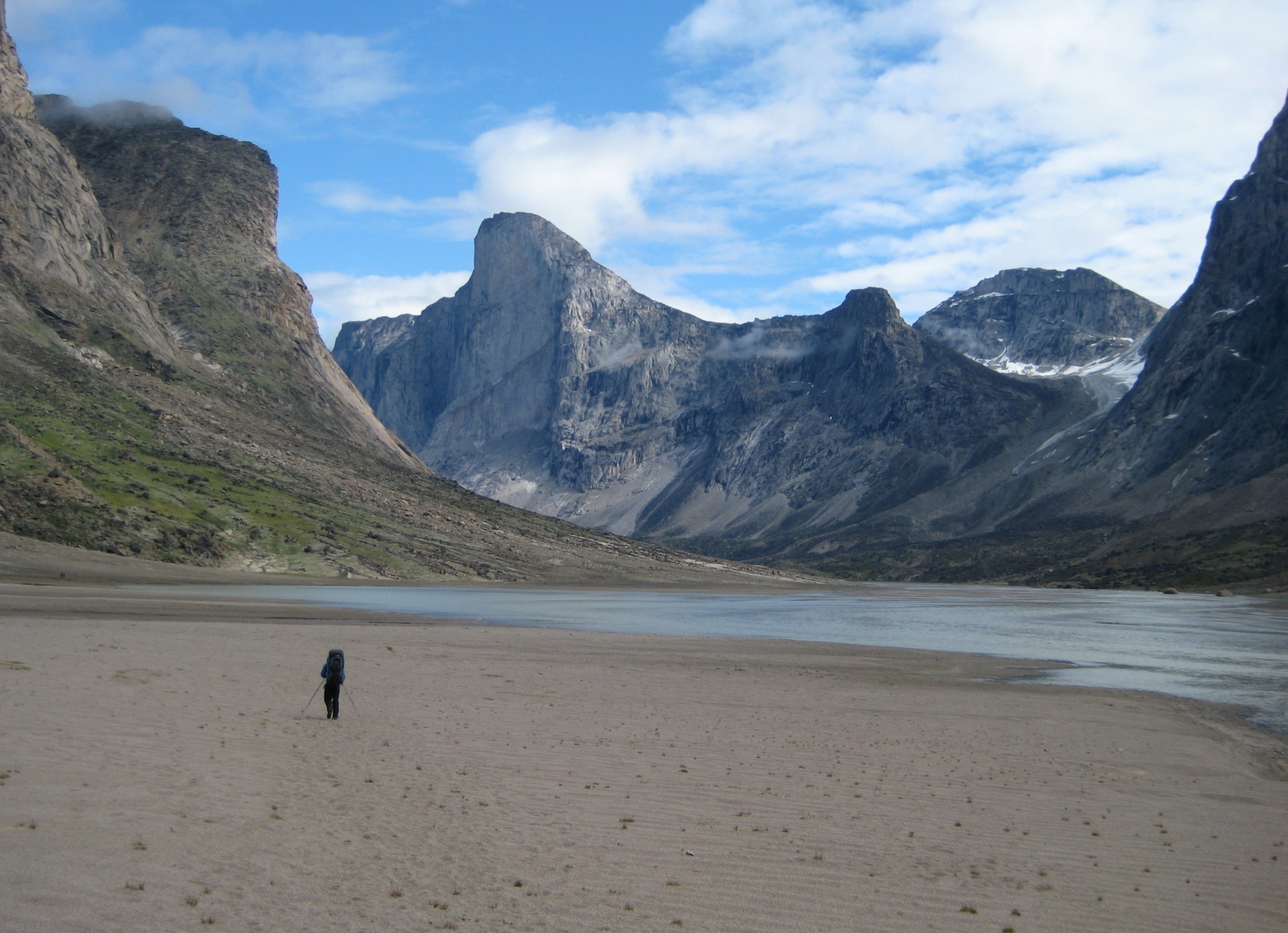
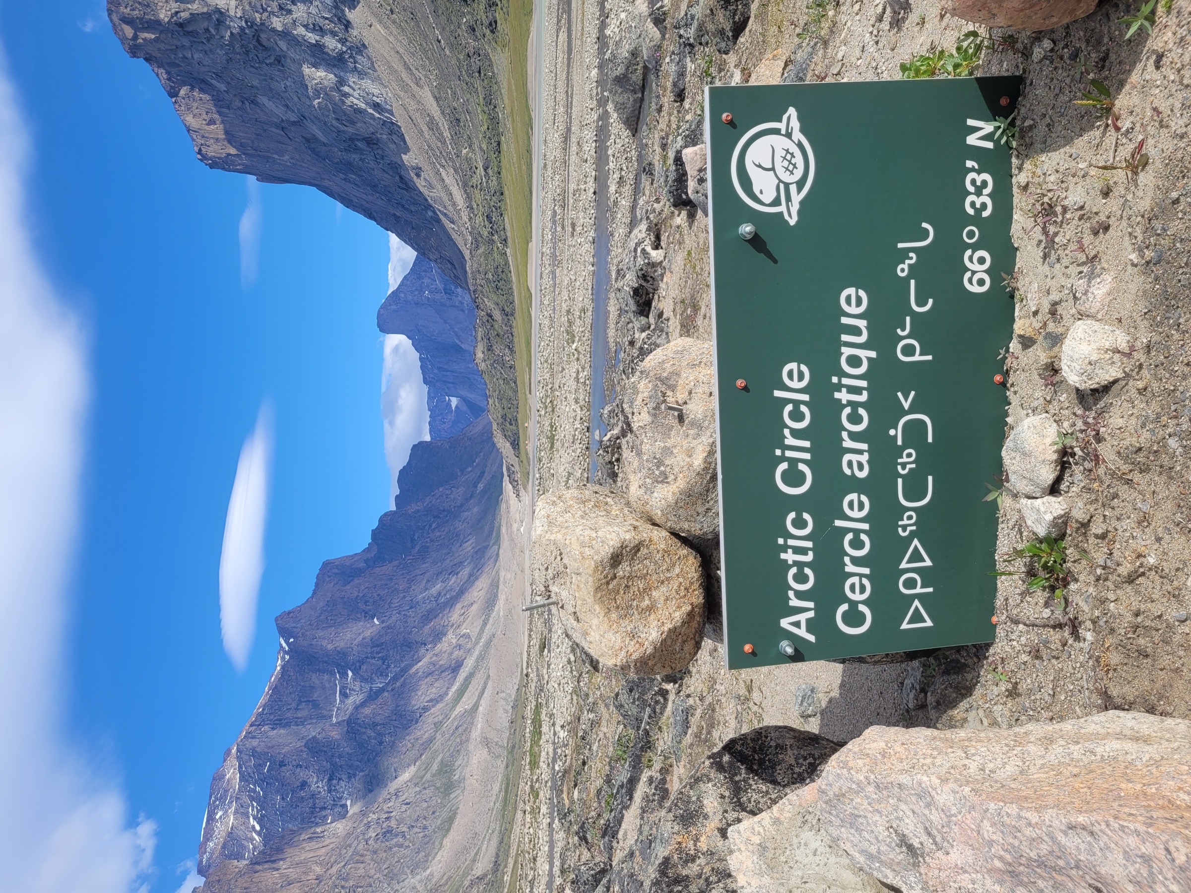
4. Arctic Circle and Crater Lake from Overlord
Snapshot
Itinerary
In spring, Parks Canada runs the trip on selected Saturdays in April by snowmobile and qamutik (Inuit sled) from Pangnirtung. After park orientation at the Auyuittuq Visitor Centre at 08:30, the group crosses Pangnirtung Fiord, enters the park at Overlord and continues up the frozen Weasel River, stopping below Crater Lake. From there, participants walk on foot up to Crater Lake — a moraine-dammed pond at the head of the lower Weasel valley — and continue to the Arctic Circle marker, a Parks Canada sign on the west bank of the Weasel River with Mount Thor visible to the north. In summer, the itinerary is delivered with a motorboat to Overlord and a longer on-foot section up the Weasel River valley; the full Overlord-to-Arctic-Circle distance is about 12.5 km each way, but most fit groups shorten this with a drop-off closer to Crater Lake. The return is on the same line.
Why it is essential
The Arctic Circle marker at the Weasel River is one of the few formal landmarks in Auyuittuq National Park reachable as a day objective. It crosses a culturally significant landscape — the Akshayuk Pass has been used by Inuit travellers for generations — and gives a direct view of Mount Thor, the Weasel River and Schwartzenbach Falls on the opposite valley wall. It is the standard day-visitor experience of the park.
Equipment
Equipment varies with season. Spring trip: full insulated layering, windproof shell, balaclava, mitts, sunglasses for snow glare; Parks Canada and the outfitter supply the qamutik and operational kit. Summer trip: waterproof boots, weatherproof shell, warm layer, hat, gloves, water, food, sun protection. Mandatory Parks Canada orientation and permit; park entry fee applies. The guide carries a bear deterrent.
Hazards and notes
The spring version depends entirely on sea-ice and river-ice conditions. The summer version depends on river levels — the Weasel River can require unbridged crossings; the historic Windy Lake suspension bridge was washed out in 2008 and is gone. Polar bears are a known hazard. Weather changes rapidly. All access requires a Parks Canada permit and orientation; cash or e-transfer only for the outfitter. Confirm dates and conditions with Parks Canada Pangnirtung (867-473-2500) before travel.
GPX / KML links
| Source | URL | Format / access | Reuse status |
|---|---|---|---|
| Parks Canada — Experience the Arctic Circle | parks.canada.ca | Programme page; no GPX | Crown copyright; no reusable route file |
| OpenStreetMap — Akshayuk Pass corridor | openstreetmap.org near Akshayuk Pass | OSM data (ODbL) | Lower Weasel River corridor partially mapped |
Approximate Arctic Circle marker location: 66 33 N, 65 20 W, on the west bank of the Weasel River, Auyuittuq National Park.
External links
- Parks Canada — Experience the Arctic Circle
- Parks Canada — Hiking, Auyuittuq National Park
- Wikipedia — Akshayuk Pass
5. Qikiqtan (Kekerten) Whaling-Station Interpretive Trail
Snapshot
Itinerary
Kekerten Island lies in Cumberland Sound roughly 50 km south of Pangnirtung; the passage by chartered Inuit-guided motorboat takes about three hours each way. On the island, an interpretive walking trail links the principal remains of the 19th-century Scottish and American whaling station: foundations of storehouses built in 1857, cast-iron try-pots once used for rendering whale oil, blubber-hauling pins, ship-wreck remnants, and the whalers’ graveyard. Signage at each station explains the history in English, Inuktitut and (on some panels) French. Whale-spotting lookouts on the coastline give views over Cumberland Sound. Visitors stay on the boardwalk and signed line through the historic site. The walk itself is short and flat; the day is full because of travel time.
Why it is essential
Kekerten (Qikiqtan Territorial Park) is the only signed, formally interpreted walking trail on the Cumberland Peninsula outside Auyuittuq. It is also a Canadian National Historic Site, recording the most important whaling station of Cumberland Sound (1860-1880) and a key chapter of Inuit-European contact on Baffin Island. For a cultural and historical day on the peninsula it is the standard choice.
Equipment
Standard hiking equipment: waterproof boots, weatherproof shell, warm layer (an open boat is cold even in July), hat, gloves, water, food, sun protection. The guide’s outfit handles bear safety. Binoculars for whale and seabird spotting from the boat. Camera. Confirm outfitter, sea-state and timing in advance.
Hazards and notes
The principal hazard is the boat passage, not the walking. Cumberland Sound can be rough; trips are routinely postponed for weather. Polar bears are sometimes recorded on Kekerten Island; the guide carries deterrents. Visitors are asked not to leave the marked path through the historic site. The site is administered as Qikiqtan Territorial Park by the Government of Nunavut; respect any temporary closures advised by Nunavut Parks or the Hamlet of Pangnirtung. Bring all food and water for the day; there are no services on the island.
GPX / KML links
| Source | URL | Format / access | Reuse status |
|---|---|---|---|
| Nunavut Parks — Kekerten (Qikiqtan) Territorial Park | nunavutparks.com | Park page; no GPX | Government of Nunavut; no reusable route file |
| Parks Canada — Kekerten Island Whaling Station NHS | pc.gc.ca | NHS page; no GPX | Crown copyright; no reusable route file |
Approximate boat landing: Kekerten Island, ~65 41 N, 65 20 W.
External links
- Nunavut Parks — Kekerten (Qikiqtan) Territorial Park
- Parks Canada — Kekerten Island Whaling Station NHS
- Government of Nunavut — Kekerten brochure (PDF)
Missing data / follow-up work
- No official GPX file exists for any of the five routes. AllTrails and Wikiloc have user-uploaded traces for Mount Duval that should be cross-checked against OpenStreetMap; reuse is restricted by AllTrails terms and Wikiloc per-track licences.
- Mount Duval elevation: Wikipedia and Mountain-Forecast quote 850 m; PeakVisor’s body text gives 670 m but the same page contradicts itself by listing the nearest higher peak at 745 m. The 850 m figure is used here and should be confirmed against the 1:50,000 NTS topographic sheet (NTS 026-I).
- Mount Duval distance and gain are derived from the sea-level Pangnirtung start, the ~2 km horizontal separation between hamlet and summit, and the 850 m summit altitude. Confirm with a measured GPX trace.
- Pisuktinu Tunngavik Territorial Park: Nunavut Parks and Travel Nunavut describe two distinct trails (shoreline and ridge) but do not publish distances, gain or a trail map. Distances and gain are estimated.
- Ulu Peak day trip: Parks Canada does not publish walking distance, gain or a specific landing coordinate. Confirm with the park office for the 2026 season; outfitter price and park entry fee should be updated.
- Arctic Circle / Crater Lake day trip: 2026 dates and transport mode (snowmobile in spring vs boat in summer) must be confirmed with Parks Canada Pangnirtung. The Windy Lake bridge across the Weasel River is gone (washed out 2008); current crossing options should be confirmed.
- Kekerten interpretive trail: precise on-ground distance is not published; estimate is from the brochure footprint. No licence-compatible photograph of the site has been confirmed.
- A Qikiqtarjuaq Inukshuk Hill / community walk was considered for the fifth slot and set aside in favour of Kekerten because route description and distances could not be verified beyond cruise-operator material. Worth a future verification pass with Qik.travel and the Hamlet of Qikiqtarjuaq.
- All routes outside the immediate settlement footprints require local Inuit guides for safety (polar bears) and cultural reasons; no national booking system exists. Confirm outfitters seasonally.
- Public transport: there is none. Access is by scheduled fixed-wing flight to Pangnirtung (YXP) or Qikiqtarjuaq (YVM) from Iqaluit, then on foot or by chartered boat or snowmobile.
External links
| Resource | Link |
|---|---|
| Parks Canada — Auyuittuq National Park | parks.canada.ca |
| Parks Canada — Guided day trips, Auyuittuq | parks.canada.ca |
| Parks Canada — Hiking, Auyuittuq | parks.canada.ca |
| Parks Canada — Discover Ulu Peak | parks.canada.ca |
| Parks Canada — Experience the Arctic Circle | parks.canada.ca |
| Parks Canada — Kekerten Island Whaling Station NHS | pc.gc.ca |
| Nunavut Parks — Pisuktinu Tunngavik Territorial Park | nunavutparks.com |
| Nunavut Parks — Kekerten (Qikiqtan) Territorial Park | nunavutparks.com |
| Nunavut Tourism — Auyuittuq National Park | nunavuttourism.com |
| Travel Nunavut — Pangnirtung community | travelnunavut.ca |
| Travel Nunavut — Qikiqtarjuaq community | travelnunavut.ca |
| Wikipedia — Cumberland Peninsula | en.wikipedia.org |
| Wikipedia — Auyuittuq National Park | en.wikipedia.org |
| Wikipedia — Akshayuk Pass | en.wikipedia.org |
| Wikipedia — Pangnirtung | en.wikipedia.org |
| Wikipedia — Mount Duval (Nunavut) | en.wikipedia.org |
| Wikimedia Commons — Category: Auyuittuq National Park | commons.wikimedia.org |
| Wikimedia Commons — Category: Pangnirtung | commons.wikimedia.org |