Regional overview
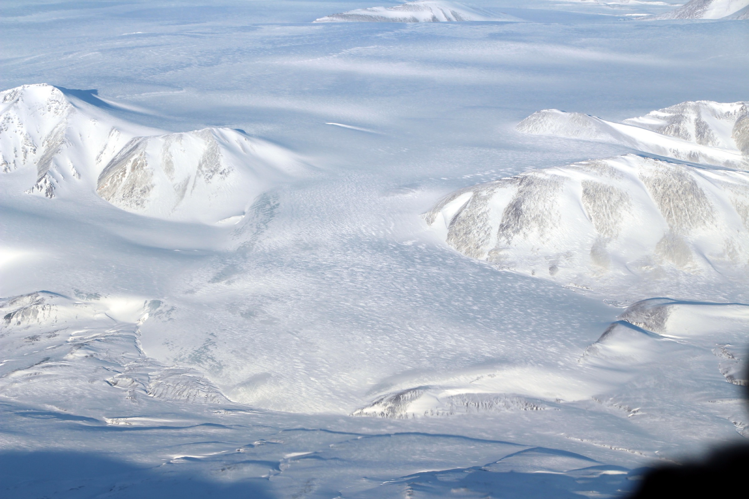
The United States Range is the northernmost named mountain range in the Canadian Arctic, occupying the central spine of northern Ellesmere Island (Nunavut) inside Quttinirpaaq National Park. Its highest summit, Barbeau Peak (2,616 m), is the high point of the Canadian Arctic and of all the Arctic east of the Yukon. The range is heavily glaciated — the Grant Ice Cap, Viking Ice Cap and lobes of the Per Ardua, Air Force and Henrietta Nesmith glaciers feed valleys and fiords on all sides — and is uninhabited. There are no roads, no trails and no infrastructure inside the range itself; all documented foot travel within the range is mountaineering, with parties landed by ski-equipped Twin Otter on glacier névé and travelling roped with sleds over multi-week expeditions.
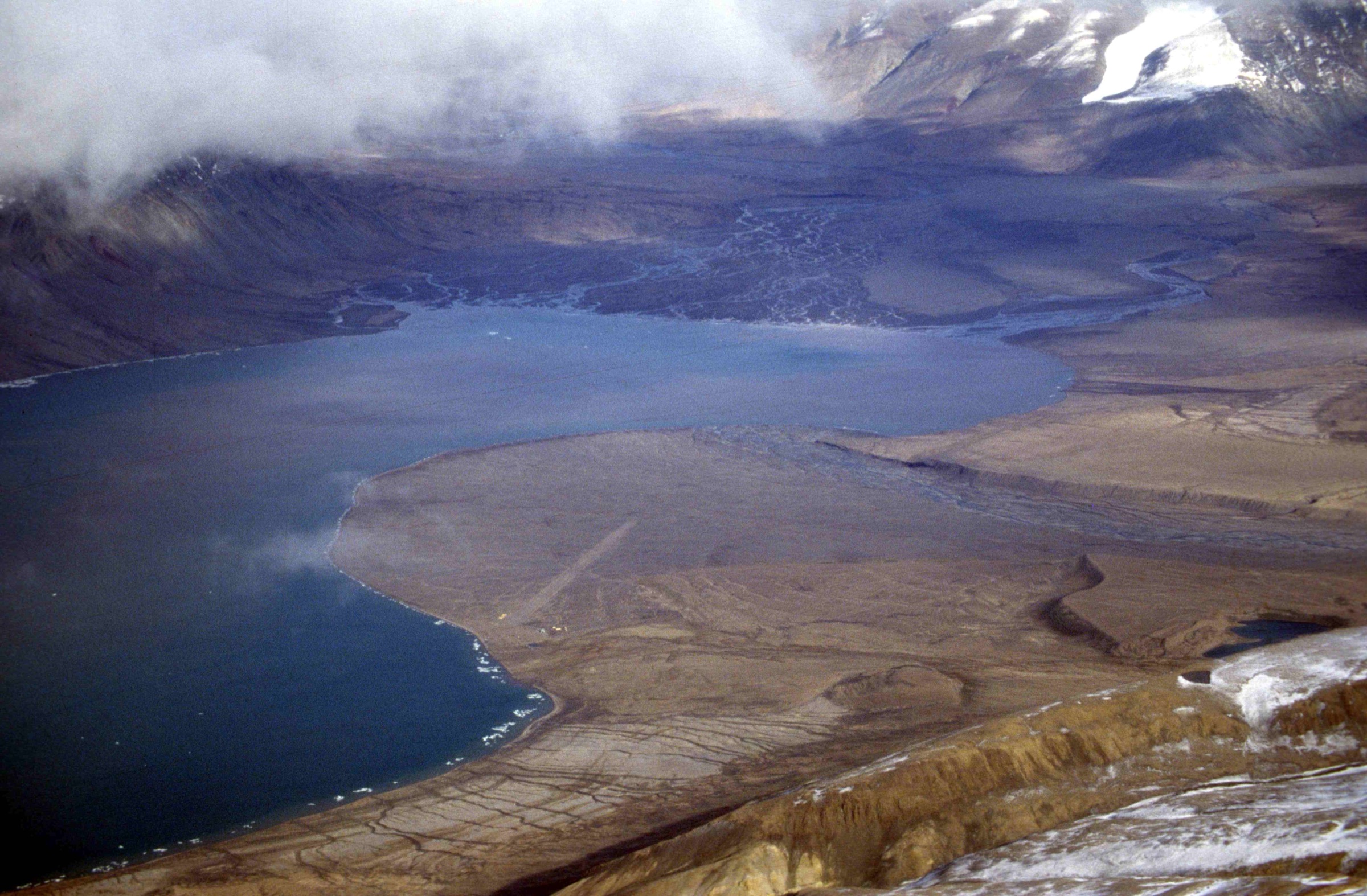
What is realistically walkable as a day-hike in Quttinirpaaq sits in the southern foothills, around the Tanquary Fiord warden station at the head of the fiord of the same name. The country here is a low, treeless landscape of glacially polished granite, tundra meadows, ancient raised marine beaches and braided meltwater rivers, with the snouts of the Per Ardua, Air Force and Macdonald glaciers visible to the north and the high snowfields of the United States Range itself forming the distant skyline on clear days. The Lake Hazen (“Tasialuk”) operational station, 100 km north-east of Tanquary at the south foot of the range, is a Parks Canada emergency and staging facility with no published day-hike infrastructure of its own; the Kettle Lake interpretive walking-tour is a Tanquary route in interpretive form. Documented day-hiking in this catalogue therefore means day-hikes from Tanquary Fiord, in country technically on the south flank of the United States Range. The five routes below are taken directly from the Parks Canada 2025 Hiking Routes Guide from Tanquary Fiord.
The hiking season is short and absolute. Snow and river ice break up in mid-June; the rivers are normally crossable from late June through August, and by early September the season is over. The land is in 24-hour daylight from mid-April to late August. Magnetic compasses are unreliable across the park (“area of compass unreliability” — Parks Canada). Maximum group size is 9 people, park-wide. Access is by Canadian North scheduled flight to Resolute Bay (CYRB) via Iqaluit, followed by a Kenn Borek Air Twin Otter charter to the Tanquary airstrip; the round-trip Parks Canada-quoted charter for 2026 is approximately CAD 60,000 (8–9 passengers, ~1,200 kg payload), and flight-sharing is the standard arrangement. Mandatory orientation and registration at the warden station is required on arrival, and de-registration on departure. Fees for 2026: CAD 17.75 per person/day-use, CAD 37.00 per person/night backcountry; a CAD 256.50 Northern Backcountry Annual Pass covers ten Nunavut/NWT/Yukon parks. The federal Discovery Pass is not valid in Nunavut.
The principal hazards are river crossings (the Macdonald River can be impassable for days; lowest water is typically 02:00–07:00 in cold spells) and weather. Polar bear encounters are described by Parks Canada as low-frequency but possible anywhere, including on glaciers. An Iridium satellite phone is strongly recommended — Globalstar and SPOT do not reliably function at this latitude — and a registered 406 MHz PLB or InReach is standard practice. Bear spray is prohibited on scheduled flights; deterrents must be sourced after arrival (limited loan stock from Parks Canada). Camping is prohibited within 1.5 km of Kettle Lake (archaeology) and within 3 km of Lewis Lake.
Selection rationale
These five day-hikes are taken directly from the Parks Canada 2025 Hiking Routes Guide from Tanquary Fiord, which catalogues six published day-hikes from the warden station; the sixth (Grassy Loop) is omitted because it largely overlaps Hunters’ Walls plus May Creek Ridge. The selection balances a short cultural and interpretive walk (Kettle Lake), an archaeological short walk with glacier views (Hunters’ Walls), a single panoramic ridge climb (May Creek Ridge), a long flat valley walk to a named natural feature (Macdonald River Waterfall) and a tundra summit hike with a 360° view (Mount Timmia). The United States Range proper has no day-hikes; the range appears only as the high snowfield skyline from the higher viewpoints in this set.
Summary table
| # | Hike | Country | Route type | Distance | Gain | Max elevation | Difficulty |
|---|---|---|---|---|---|---|---|
| 1 | Kettle Lake Loop | Canada | Loop | 5 km | 70 m | ~50 m | Easy–moderate |
| 2 | Hunters’ Walls Hike | Canada | Out-and-back | 6 km | 140 m | ~140 m | Easy–moderate |
| 3 | May Creek Ridge | Canada | Out-and-back | 8 km | 640 m | ~640 m | Moderate |
| 4 | Macdonald River Valley Waterfall | Canada | Loop | 13 km | 100 m | ~100 m | Moderate |
| 5 | Mount Timmia Loop | Canada | Loop | 14 km | 860 m | ~860 m | Moderate–difficult |
1. Kettle Lake Loop
Snapshot
Itinerary
The route leaves the warden station and crosses two prominent ancient marine beach ridges, raised by post-glacial isostatic rebound, before dropping to the rim of Kettle Lake — a small, clear freshwater pond perched above Tanquary Fiord. Parks Canada has produced an eleven-stop interpretive walking-tour for this loop (Kettle Lake Walking Tour PDF), with stops describing geology, raised beaches, fossil whale bones, an Independence I culture stone tent ring (c. 2000 BCE) and a later Thule winter house ruin. The loop continues around the lake and returns by a parallel beach-ridge line. Camping is prohibited within 1.5 km of Kettle Lake to protect the archaeological sites.
Why it is essential
The single best introductory walk in the park: short, easy, and the only documented day-hike that combines two distinct cultural-resource sites (Independence I and Thule), a textbook Arctic raised-beach landscape, and the iconic Tanquary Fiord viewpoint. It is also the only Tanquary route with a published Parks Canada interpretive companion.
Equipment
- Sturdy boots
- Weatherproof shell and warm insulating layer
- Hat and gloves outside the warmest part of July
- 1 L water
- Sun protection
- Bear deterrent (issued at warden station if available)
- Iridium sat phone or InReach
- Gaiters or neoprene socks if the lake outflow is high
Hazards and notes
Designated archaeological site; do not remove or disturb artefacts. Sudden weather changes are normal — wind chill at this latitude can drop the felt temperature 15–20 °C below the air temperature. Polar bear encounter probability is low but non-zero. No camping within 1.5 km of Kettle Lake. Park-wide group-size cap of nine applies.
GPX / KML links
| Source | URL | Format | Notes |
|---|---|---|---|
| Parks Canada — Kettle Lake Walking Tour | parks.canada.ca | PDF (sketch map; not for navigation) | Crown copyright; no GPX exists |
| Parks Canada — Hiking Routes Guide from Tanquary Fiord | parks.canada.ca | Crown copyright; overview only | |
| OpenStreetMap | openstreetmap.org | OSM data | ODbL; only the warden-station and airstrip nodes |
Sources
- Parks Canada — Hiking Routes Guide from Tanquary Fiord (2025)
- Parks Canada — Kettle Lake Walking Tour
- Parks Canada — Quttinirpaaq National Park
2. Hunters’ Walls Hike
Snapshot
Itinerary
The route leaves the warden station and crosses May Creek (low water 02:00–07:00; a wet ford in most conditions) before ascending a tundra hillside to a low ridge with two man-made low rock walls. Parks Canada attributes these “walls” to caribou or muskox hunters of unknown date. From the ridge the route gives the best low-altitude view of Gull Glacier descending towards Tanquary Fiord, with the wider Per Ardua and Air Force glacier complex visible to the north. The name “Hunters’ Walls” is unofficial (the Parks Canada brochure marks it with an asterisk).
Why it is essential
A short, half-day archaeological objective with an excellent first close-range view of a Quttinirpaaq glacier. The route reaches the type of high-ground viewpoint that the park’s larger overnight expeditions reach only after several days of valley travel.
Equipment
- Sturdy boots
- Neoprene socks or gaiters for May Creek
- Weatherproof shell and warm layer
- Hat and gloves outside midsummer
- 1.5 L water
- Bear deterrent
- Iridium sat phone or InReach
- 1:50,000 NTS 340D topographic sheet plus GPS (compasses unreliable)
Hazards and notes
May Creek crossing is the single significant hazard: avoid the warm hours of the afternoon when meltwater is highest. Loose talus on the upper hillside. Wind exposure on the ridge. Standard polar bear precautions.
GPX / KML links
| Source | URL | Format | Notes |
|---|---|---|---|
| Parks Canada — Hiking Routes Guide from Tanquary Fiord | parks.canada.ca | PDF sketch map | Crown copyright; no GPX exists |
| OpenStreetMap | openstreetmap.org | OSM data | ODbL; no trail geometry |
Sources
- Parks Canada — Hiking Routes Guide from Tanquary Fiord (2025)
- Parks Canada — Quttinirpaaq hiking page
3. May Creek Ridge
Snapshot
Itinerary
The route follows May Creek upstream from the warden station, then climbs the steep tundra and scree shoulder on the ridge’s south flank, gaining roughly 640 m in 4 km. The ridge top gives the most comprehensive low-altitude panorama in the park: Mount Bowman and the Grassy Loop valley to the south, Tanquary Fiord and the Viking Ice Cap to the east, Mount Timmia and the Per Ardua Glacier to the north, and the Air Force and Macdonald valleys with the United States Range high snowfields beyond to the north-east. Return is by the same line.
Why it is essential
Parks Canada describes May Creek Ridge as the single best panoramic day-hike from Tanquary; it is the only day-hike in the park that places a walker high enough to see the United States Range proper as a continuous skyline. The 640 m of gain is significant for a Quttinirpaaq day-hike — only Mount Timmia gains more.
Equipment
- Sturdy boots (loose scree on the upper ridge)
- Trekking poles
- Extra warm layer, hat and gloves
- Full waterproofs
- 2 L water
- 1:50,000 NTS 340D plus GPS (compasses unreliable)
- Iridium sat phone or InReach
- Microspikes early in the season if hardpack lingers on the ridge
- Bear deterrent
Hazards and notes
The ridge is fully exposed to wind. Sudden ground blizzards remain possible into July. Loose talus and scree on the climb and descent. May Creek high water is the bail-out hazard on return. Compass unreliability — confirm bearings against terrain features. Standard polar bear precautions.
GPX / KML links
| Source | URL | Format | Notes |
|---|---|---|---|
| Parks Canada — Hiking Routes Guide from Tanquary Fiord | parks.canada.ca | PDF sketch map | Crown copyright; no GPX exists |
| OpenStreetMap | openstreetmap.org | OSM data | ODbL; no trail geometry |
Sources
4. Macdonald River Valley Waterfall Loop
Snapshot
Itinerary
The route follows the flat outwash and braid plain of the Macdonald River upstream from Tanquary Fiord. The valley floor is muskox habitat, with Arctic willow, mountain sorrel and saxifrage in the wet pockets. Roughly 6.5 km from the warden station an unnamed tributary tumbles off the valley’s east ridge as a sheer-drop waterfall — the day’s turnaround feature, and one of the documented locations in the park for Porsild’s Bryum (Mielichhoferia macrocarpa), a moss listed under the federal Species at Risk Act. Return is via the opposite side of the river where the river level permits.
Why it is essential
The only day-hike in the park that lets a walker spend a full day in a true Quttinirpaaq glacial valley — gravel braid-plain, muskox sign and a named geomorphic feature — without significant climbing. It complements the panoramic May Creek Ridge by contrast.
Equipment
- Sturdy boots
- Neoprene socks or wading boots for the river fords
- Trekking poles for stability in the river
- Warm and waterproof layers
- 2 L water
- Bear deterrent
- Iridium sat phone or InReach
Hazards and notes
The Macdonald River is the single largest hazard in the Tanquary day-hike network: it can rise quickly, run silt-grey and become unfordable for days. Plan the crossing for the coldest part of the day (lowest water 02:00–07:00). Do not approach or disturb muskox; give wide berth. Do not remove or disturb the Porsild’s Bryum at the falls — it is a SARA-listed species. Standard polar bear precautions.
GPX / KML links
| Source | URL | Format | Notes |
|---|---|---|---|
| Parks Canada — Hiking Routes Guide from Tanquary Fiord | parks.canada.ca | PDF sketch map | Crown copyright; no GPX exists |
| OpenStreetMap | openstreetmap.org | OSM data | ODbL; no trail geometry |
Sources
- Parks Canada — Hiking Routes Guide from Tanquary Fiord (2025)
- Government of Canada — Species at Risk public registry
5. Mount Timmia Loop
Snapshot
Itinerary
The route fords the Macdonald River (low water 02:00–07:00 only) and climbs the long south ridge of Mount Timmia in a single sustained ascent of ~860 m over roughly 5 km. The summit gives a 360° panorama over the Per Ardua Glacier and Viking Ice Cap to the north, the Macdonald and Omega Lakes valleys to the east, Tanquary Fiord to the south, and Mount Bowman and the Grassy Loop to the west. The descent follows the ridge on the north-west side, completing a loop and re-fording the Macdonald near the warden station.
Why it is essential
Mount Timmia is the standout summit day-hike from Tanquary, gaining the most elevation of any day-route and yielding the highest-altitude panorama short of the multi-day Mount Bowman loop. It is the closest a day-hiker can come to a “summit” experience in Quttinirpaaq without committing to a glaciated peak.
Equipment
- Sturdy boots
- Trekking poles
- Extra warm and wind layers, hat and gloves
- Full waterproofs
- Neoprene socks or wading boots for the Macdonald ford
- 2.5 L water
- Headtorch (sun barely sets in late August but redundancy is standard)
- 1:50,000 NTS 340D plus GPS (compasses unreliable)
- Iridium sat phone or InReach
- Microspikes if hardpack remains on the upper ridge
- Bear deterrent
Hazards and notes
Two Macdonald River fords are required (outbound and return). Plan both for the coldest hours; carry extra time and food in case the return ford is impassable and the party has to wait or detour. The upper ridge is fully exposed to wind; ground blizzards and whiteouts are possible into July. Loose scree on the climb. Compass unreliability throughout. Standard polar bear precautions.
GPX / KML links
| Source | URL | Format | Notes |
|---|---|---|---|
| Parks Canada — Hiking Routes Guide from Tanquary Fiord | parks.canada.ca | PDF sketch map | Crown copyright; no GPX exists |
| OpenStreetMap | openstreetmap.org | OSM data | ODbL; no trail geometry |
Sources
External links
| Source | URL |
|---|---|
| Parks Canada — Quttinirpaaq National Park | parks.canada.ca |
| Parks Canada — Quttinirpaaq activities | parks.canada.ca |
| Parks Canada — Quttinirpaaq hiking | parks.canada.ca |
| Parks Canada — Quttinirpaaq maps and brochures | parks.canada.ca |
| Parks Canada — Hiking Routes Guide from Tanquary Fiord (2025, PDF) | parks.canada.ca |
| Parks Canada — Kettle Lake Walking Tour (PDF) | parks.canada.ca |
| Parks Canada — 2026 Visitor Information Package (PDF) | parks.canada.ca |
| Parks Canada — Quttinirpaaq fees | parks.canada.ca |
| Parks Canada — Quttinirpaaq directions | parks.canada.ca |
| Kenn Borek Air | borekair.com |
| Black Feather — Quttinirpaaq Basecamp expedition | blackfeather.com |
| Black Feather — Ad Astra Trek | blackfeather.com |
| American Alpine Journal — Barbeau Peak (mountaineering reference) | publications.americanalpineclub.org |
| Wikimedia Commons — Quttinirpaaq National Park | commons.wikimedia.org |
| OpenStreetMap (ODbL 1.0) | openstreetmap.org |