.JPG)
Regional overview
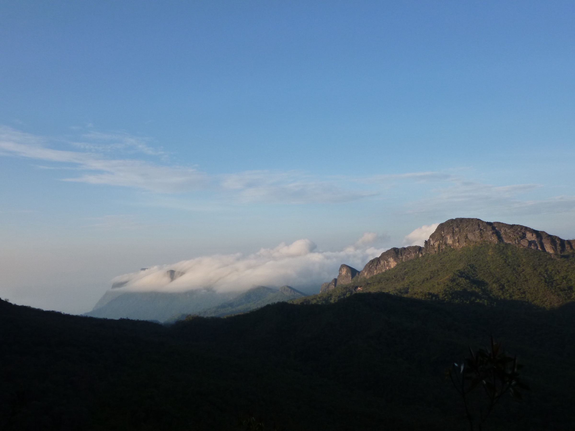
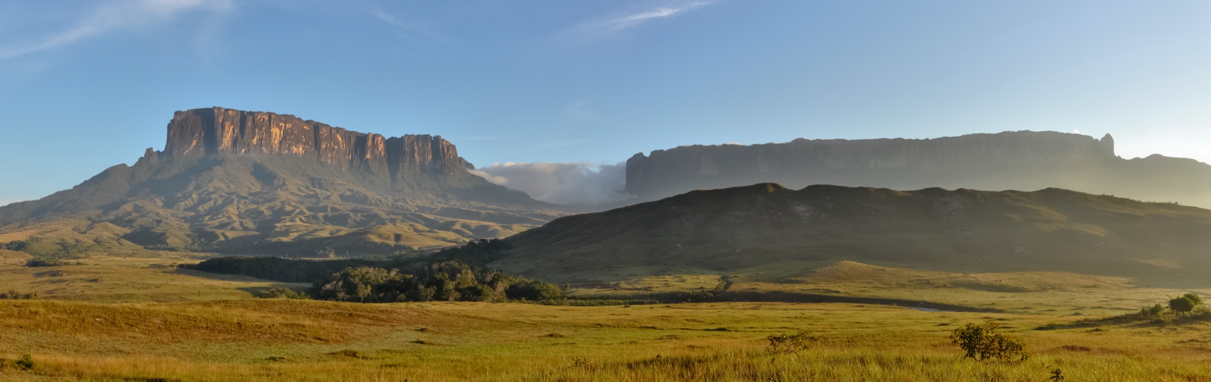
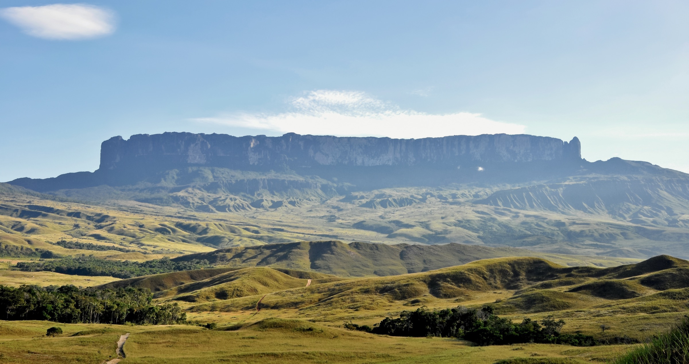
The Brazil-Venezuela border highlands include the Roraima/Pacaraima tepui country, the Brazilian Parque Nacional do Monte Roraima within Terra Indigena Raposa Serra do Sol, and the Venezuelan Gran Sabana sector of Canaima National Park. The region is famous for Mount Roraima, Kukenan and a chain of waterfalls and open savannah landscapes.
The best-known mountain route, Mount Roraima from the Venezuelan side, is a multi-day trek rather than a day hike. Shorter Gran Sabana waterfall walks are feasible as day outings, while Brazilian-side access is shaped by Indigenous territory and national-park arrangements. Current access, guiding, fuel and road conditions need local confirmation.
This entry separates true or likely day walks from multi-day classics. Several statistics remain approximate or unresolved because public route files are scarce.
Selection rationale
The five entries represent the border-highlands essentials without inventing independent access: Mount Roraima as the iconic but non-day trek; Quebrada de Jaspe, Salto Kawi/Kama and Aponwao Falls as Gran Sabana day-walk objectives; and the Brazilian Monte Roraima National Park / Raposa Serra do Sol context as a protected-area access candidate.
Summary table
| # | Hike | Country | Route type | Distance | Gain | Max elevation | Difficulty |
|---|---|---|---|---|---|---|---|
| 1 | Mount Roraima trek — day-hike status check | Venezuela / Brazil / Guyana border | Multi-day trek, not day hike | 71.3 km full route | 3,875 m | 2,703 m | Hard expedition trek |
| 2 | Quebrada de Jaspe / Kako Paru | Venezuela | Short out-and-back | Unresolved | Minimal; unresolved | Unresolved | Easy-moderate |
| 3 | Salto Kawi / Kawi Meru | Venezuela | Short out-and-back | ca. 0.3-1 km local walk | Minimal; unresolved | Unresolved | Moderate (slippery rock) |
| 4 | Aponwao Falls / Chinak Meru | Venezuela | Boat-assisted short walk | Unresolved | Unresolved | Unresolved | Moderate logistics |
| 5 | Monte Roraima National Park — Brazilian-side access candidate | Brazil | Restricted protected-area candidate | Unresolved | Unresolved | ca. 2,800 m regional high point | Candidate only |
1. Mount Roraima trek — day-hike status check

Snapshot
Itinerary
The standard Mount Roraima route from the Venezuelan side is a long guided trek from the Gran Sabana toward the tepui, with camping, river crossings, a steep ramp ascent and plateau walking. It is included here because it defines the region, but it fails the catalogue’s day-hike constraint.
Why it is essential
Mount Roraima is the landmark tepui of the Brazil-Venezuela-Guyana border highlands. Its status must be recorded clearly so it is not accidentally downgraded into a day walk.
Equipment
- Expedition camping kit
- Waterproofs
- Warm layer
- Boots
- Food
- Water treatment
- Guide/porter arrangements
- Park permissions
- Plateau navigation equipment
Hazards and notes
- Not a day hike.
- Weather, river crossings, exposed wet rock, plateau navigation and protected-area/Indigenous rules are major factors.
GPX / KML links
| Source | URL | Format / access | Reuse status |
|---|---|---|---|
| AllTrails: Mount Roraima | alltrails.com | Source map / trail listing | AllTrails terms apply; source-map reference only |
| OpenStreetMap search: Mount Roraima | openstreetmap.org | Map source | OSM data is ODbL; geometry cross-check only |
External links
2. Quebrada de Jaspe / Kako Paru
Snapshot
Itinerary
The route is a short access walk to the red and dark bedrock stream and cascades known as Quebrada de Jaspe or Kako Paru. Public sources place it in the eastern sector of Canaima National Park / Gran Sabana and describe road access from the Santa Elena de Uairen area, but exact trail statistics were not verified.
Why it is essential
This is one of the best-known short natural stops in the Gran Sabana and represents the accessible waterfall/stream character of the border highlands.
Equipment
- Trail shoes with wet-rock grip
- Sun protection
- Water
- Rain layer
- Avoid walking on slick rock in high flows
Hazards and notes
- Wet jasper/rhyolite slabs can be slippery.
- Confirm current park access, Indigenous/local rules and whether swimming or walking on the rock is permitted.
GPX / KML links
| Source | URL | Format / access | Reuse status |
|---|---|---|---|
| OpenStreetMap search: Quebrada de Jaspe | openstreetmap.org | Map source | OSM data is ODbL; broad geography only |
External links
3. Salto Kawi / Kawi Meru
Snapshot
Itinerary
Public sources describe Salto Kawi as a waterfall area near the El Dorado-Santa Elena road, with a narrow rough path to the main fall and additional small falls upstream. Exact mapping and permitted route details were not verified in this pass.
Why it is essential
Kawi Meru is one of the named Gran Sabana roadside waterfall walks and offers a compact day objective in the Brazil-Venezuela border highland corridor.
Equipment
- Shoes with wet-rock grip
- Sun protection
- Rain layer
- Water
- Dry bag
Hazards and notes
- Slippery rock, sudden rain and water levels are the main issues.
- Confirm local permissions and current safety conditions.
GPX / KML links
| Source | URL | Format / access | Reuse status |
|---|---|---|---|
| OpenStreetMap search: Salto Kawi | openstreetmap.org | Map source | OSM data is ODbL; broad geography only |
External links
4. Aponwao Falls / Chinak Meru
Snapshot
Itinerary
Public Gran Sabana sources describe Aponwao/Chinak Meru access as a road approach to a local camp followed by a curiara boat crossing and a short walk to viewpoints. It is included as a day objective, but statistics and a reusable route line were not verified.
Why it is essential
Aponwao is one of the major named waterfalls of the Gran Sabana and represents the region’s river-and-tepui hydrology.
Equipment
- Footwear for wet ground
- Rain layer
- Sun protection
- Water
- Insect repellent
- Dry bags for boat travel
Hazards and notes
- Boat safety, water levels, road conditions and local permissions must be confirmed.
- Slippery viewpoints and sudden storms are possible.
GPX / KML links
| Source | URL | Format / access | Reuse status |
|---|---|---|---|
| OpenStreetMap search: Salto Aponwao | openstreetmap.org | Map source | OSM data is ODbL; broad geography only |
External links
5. Monte Roraima National Park — Brazilian-side access candidate
Snapshot
Itinerary
ICMBio publishes the Monte Roraima National Park page, management-plan documents and a KML for the park boundary. The park is within the Raposa Serra do Sol Indigenous territory. No legal public Brazilian-side day-hike route was verified in this pass.
Why it is essential
The Brazilian side is central to the border-highlands geography, but current evidence supports protected-area context rather than a publishable day hike.
Equipment
Unresolved; any authorised route would require local guide arrangements, tropical mountain kit, rain protection and navigation.
Hazards and notes
- Do not describe independent access until ICMBio, Indigenous territory and local community rules are confirmed.
GPX / KML links
| Source | URL | Format / access | Reuse status |
|---|---|---|---|
| ICMBio park boundary KML | gov.br/icmbio | KML boundary | Brazilian government site licence: CC BY-ND 3.0 unless otherwise stated; boundary reference only |
| OpenStreetMap search: Parque Nacional do Monte Roraima | openstreetmap.org | Map source | OSM data is ODbL; broad geography only |
External links
- ICMBio — Parque Nacional do Monte Roraima
- ICMBio — Monte Roraima park boundary KML
- Wikimedia Commons — Roraima3 (79)
Missing data / follow-up work
- Verify current Canaima National Park visitor rules, guide requirements and Indigenous/community permissions.
- Find official/local GPX or create new route geometry after route permission is confirmed.
- Confirm exact distances and gains for Quebrada de Jaspe, Kawi Meru and Aponwao.
- Confirm whether any Brazilian-side public day hike is legally available in Parque Nacional do Monte Roraima / Raposa Serra do Sol.
- No licence-compatible image was verified for Quebrada de Jaspe, Salto Kawi or Aponwao Falls in this pass.
External links
| Source | URL |
|---|---|
| ICMBio — Parque Nacional do Monte Roraima | gov.br/icmbio |
| ICMBio — Monte Roraima park boundary KML | gov.br/icmbio |
| UNESCO — Canaima National Park | whc.unesco.org |
| AllTrails — Mount Roraima | alltrails.com |
| Wikipedia — Gran Sabana | en.wikipedia.org |
| Wikipedia — Jasper Creek (Venezuela) | en.wikipedia.org |
| Wikipedia (es) — Salto Kawi | es.wikipedia.org |