Regional overview
The Serra da Bocaina is the elevated coastal massif between the towns of São José do Barreiro (SP), Cunha (SP), Paraty (RJ), and Bananal (SP), forming a tilted Atlantic-forest plateau between roughly 1,500 m and 2,088 m. The Parque Nacional da Serra da Bocaina covers about 104,000 hectares of this terrain and protects one of the most important continuous tracts of Atlantic Forest in southeastern Brazil. The walking landscape is defined by montane campos de altitude on the upper plateau, dense Mata Atlântica on the steep southeast escarpment, and a network of colonial cobbled gold-road remnants linking the inland gold fields of Minas Gerais to the colonial port of Paraty.
The main hiking centres are São José do Barreiro on the SP / inland side, where the park’s principal Posto Bocaina visitor centre and the Trilha do Ouro trailhead lie at around 1,500 m; Cunha and the Cunha-Paraty road for the Pedra da Macela approach; and Paraty itself for the Caminho do Ouro heritage walk. Trailheads in the high park are reached by gravel road from São José do Barreiro or by mountain transfer from Paraty; the Cunha-side viewpoint is roughly on the SP-171 / RJ-165 watershed.
Best conditions are the cool, drier months from April to September. Summer rainfall is heavy and the colonial cobbles can become exceptionally slippery; mist closes the upper plateau quickly in any season. The park requires ICMBio registration for entry; verify current opening windows, since flood damage occasionally closes sections of the Trilha do Ouro.
Selection rationale
The five entries combine the regional high point (Pico do Tira-o-Chapéu), the most photographed viewpoint on the Cunha-Paraty axis (Pedra da Macela), the most-walked waterfall inside the national park (Santo Isidro), the colonial gold-road heritage walk linking Paraty to the plateau (Caminho do Ouro), and a representative day section of the historic Trilha do Ouro inside the Parte Alta of the park. Together they cover the iconic, the scenic, the wet, the cultural, and the long.
Summary table
| # | Hike | Country | Route type | Distance | Gain | Max elevation | Difficulty |
|---|---|---|---|---|---|---|---|
| 1 | Pico do Tira-o-Chapéu | Brazil | Out-and-back | ~22 km | ~500 m | 2,088 m | Hard (long day) |
| 2 | Pedra da Macela | Brazil | Out-and-back | 5.3 km | 382 m | 1,840 m | Moderate |
| 3 | Cachoeira Santo Isidro | Brazil | Out-and-back | 3.0 km | ~150 m | ~1,500 m | Easy |
| 4 | Caminho do Ouro de Paraty | Brazil | Point-to-point / out-and-back | 6.0 km | ~500 m | ~700 m | Moderate |
| 5 | Trilha do Ouro day section (Veado Cordeiro) | Brazil | Out-and-back | ~16 km | ~400 m | ~1,500 m | Moderate-Hard |
1. Pico do Tira-o-Chapéu
Photo status: No licence-compatible image found in this pass.
Snapshot
Itinerary
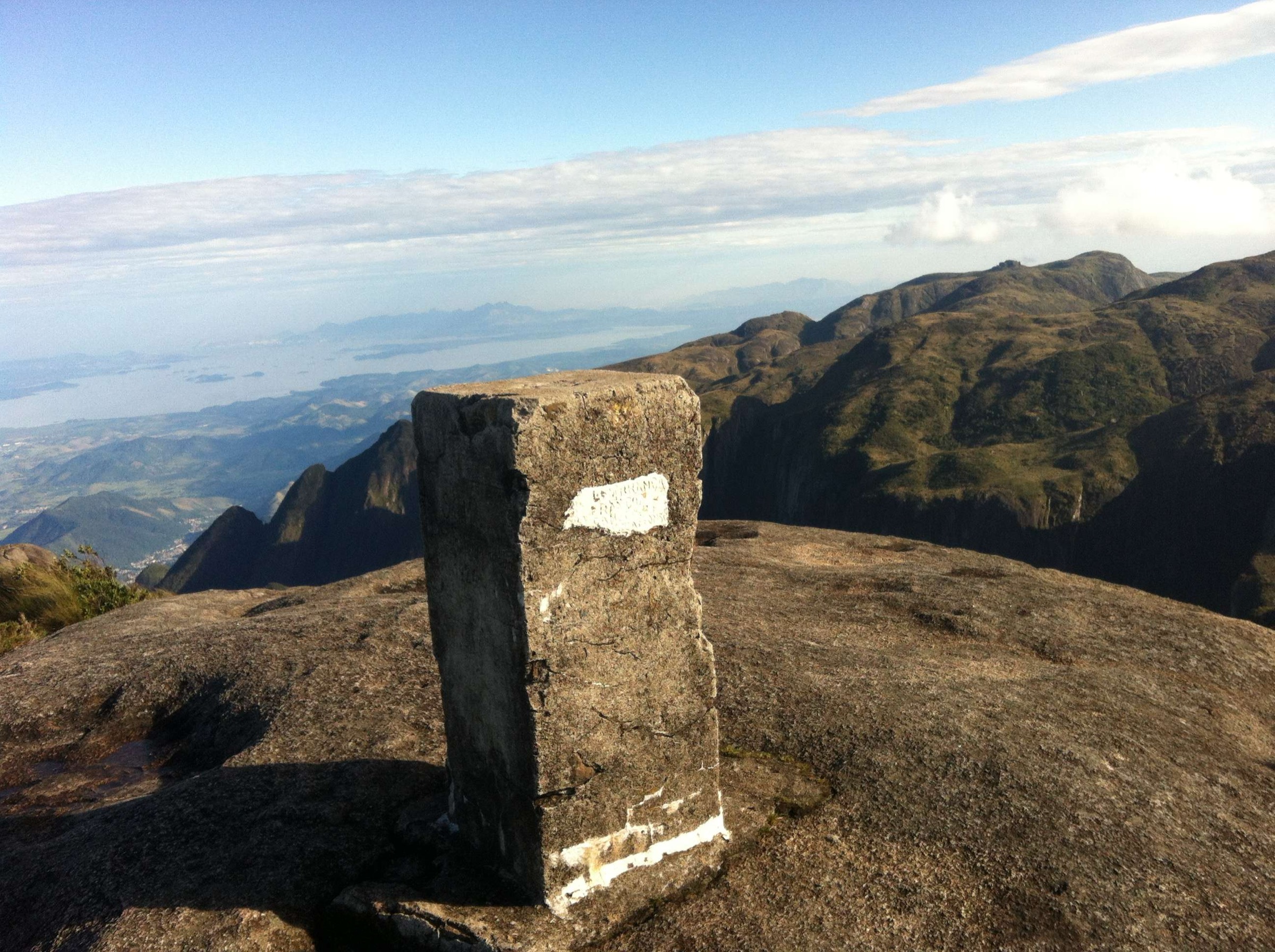
The path leaves the upper Fazenda Bocaina area on the Parte Alta gravel road and traverses the open campos de altitude of the Bocaina plateau, crossing several minor watercourses before climbing the final ridge to the summit at 2,088 m. The summit gives a panorama over the Mantiqueira, the Vale do Paraíba, and the Atlantic seaboard. The descent retraces the line of ascent; an alternative night at the ranger area or at a permitted camping site reduces the day length.
Why it is essential
Pico do Tira-o-Chapéu is the highest summit of the Parque Nacional da Serra da Bocaina and the defining objective of the upper Bocaina plateau, offering one of the broadest panoramas in the SP/RJ borderlands.
Equipment
Mountain hiking kit, sturdy boots, full waterproof and warm layers, headtorch (essential for the long day), navigation backup (map, compass, GPS), plenty of water. The plateau provides limited shelter; carry a light bivvy in less stable seasons.
Hazards and notes
The plateau loses visibility quickly in cloud; tracks are intermittently cairned and easy to lose. Camping inside the park requires ICMBio authorisation; verify current rules before travel. Cell coverage is patchy; register at Posto Bocaina before departure. Tick protection is worth considering on overgrown sections.
GPX / KML links
| Source | URL | Format / access | Reuse status |
|---|---|---|---|
| Wikiloc: Pico do Tira o Chapéu (Bocaina) | wikiloc.com | Source route page | Wikiloc terms; check author |
| AllTrails: Pico do Tira o Chapéu | alltrails.com | Source route page | AllTrails terms; GPX export/reuse not verified |
External links
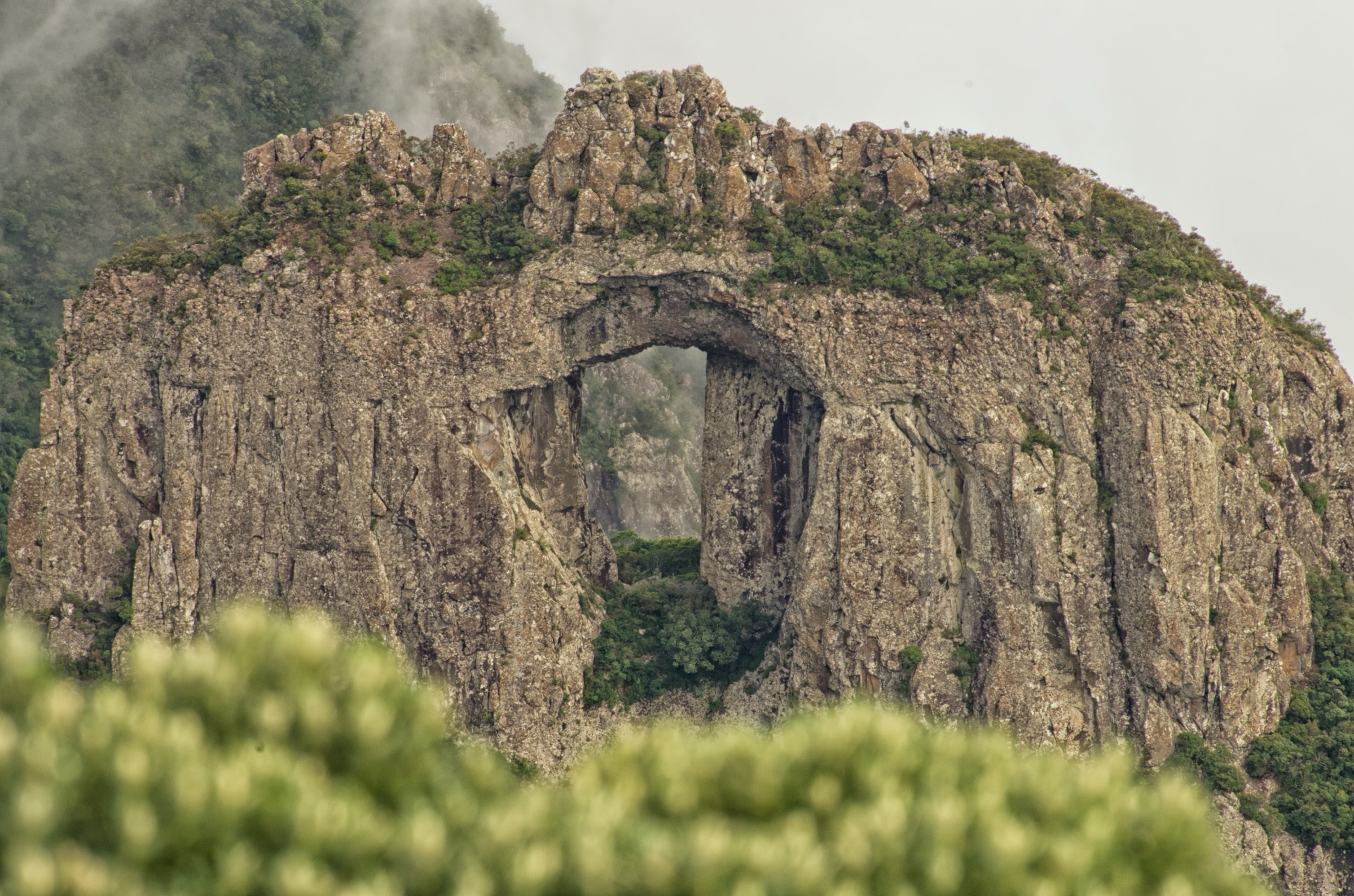
2. Pedra da Macela

Snapshot
Itinerary
The path leaves the Cunha-Paraty road at the marked Pedra da Macela trailhead, climbs through a band of cloud forest, and steepens into rocky terrain on the upper shoulder. A short ladder and chain section near the top assists the final move onto the summit slab, which gives a south-facing panorama directly over Paraty bay, the Ilha Grande archipelago, and the Atlantic coast. The descent retraces the ascent.
Why it is essential
Pedra da Macela is the defining sea-to-mountain mirante of the Bocaina region and the only point on this list where the Atlantic and the Mantiqueira are both fully visible from a single granite summit.
Equipment
Standard mountain hiking kit and sturdy boots; gloves for the upper chain section; waterproof and warm layers. Start before sunrise for the cleanest views.
Hazards and notes
The upper rock slab is exposed and dangerous in wet or windy conditions. The short ladder section is straightforward in dry weather but should not be attempted in storms or ice. Steep mud lower down after rain.
GPX / KML links
| Source | URL | Format / access | Reuse status |
|---|---|---|---|
| AllTrails: Pedra da Macela | alltrails.com | Source route page | AllTrails terms; GPX export/reuse not verified |
| Wikiloc: Pedra da Macela (Cunha) | wikiloc.com | Source route page | Wikiloc terms; check author |
External links
3. Cachoeira Santo Isidro

Snapshot
Itinerary
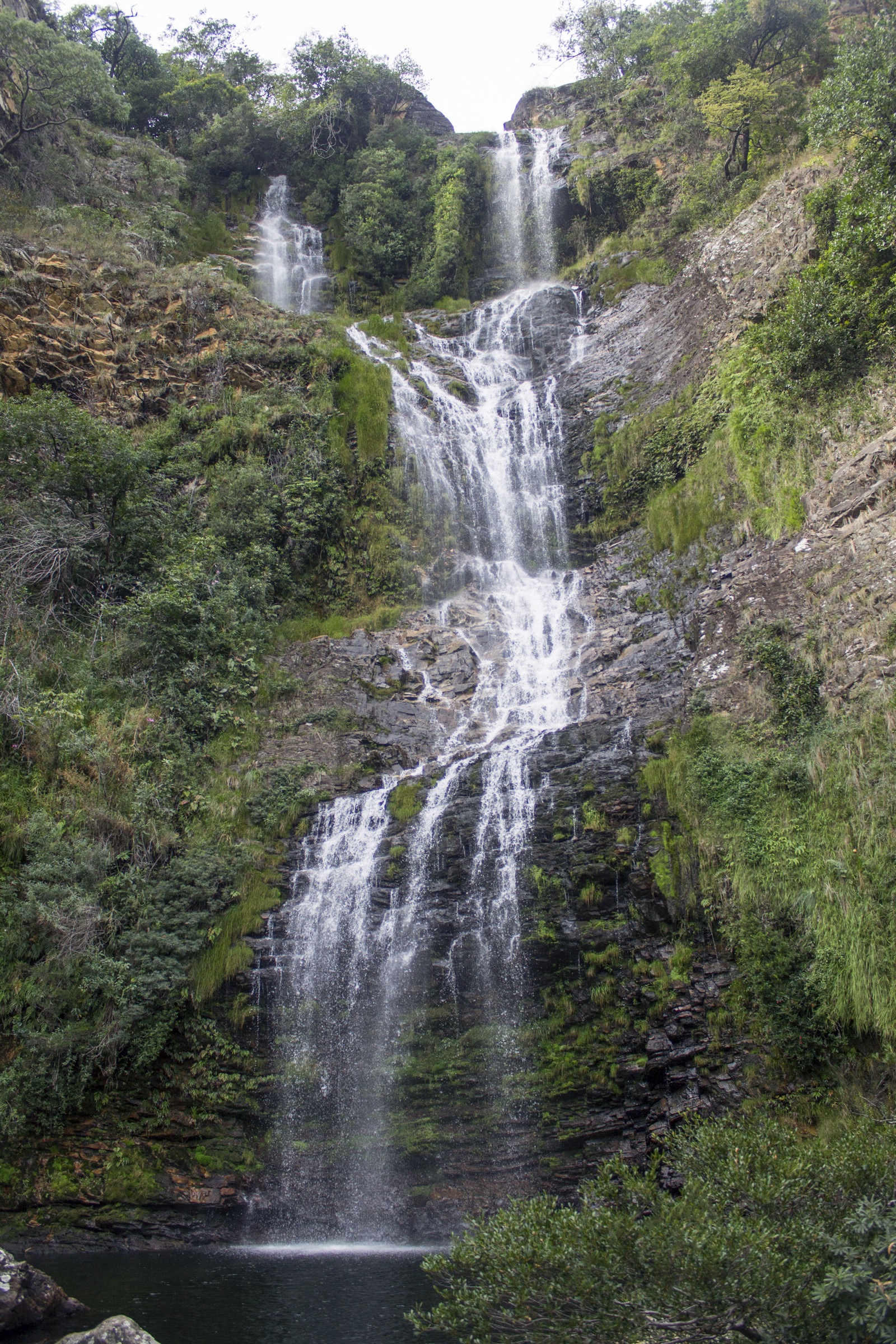
A short, well-graded forest path leaves the Posto Bocaina visitor centre on the Parte Alta plateau and drops through montane Atlantic forest to the Cachoeira Santo Isidro, a small but classic multi-tier cascade with a pool at its base. The path can be combined with a longer loop linking the Cachoeira das Posses and Veado Cordeiro on the same network.
Why it is essential
Santo Isidro is the most-walked waterfall inside the Parque Nacional da Serra da Bocaina and the easiest way to experience the park’s Atlantic-forest interior; it is also the standard “first stop” on the longer Trilha do Ouro.
Equipment
Light day-hiking kit; the trail is well marked. Swim gear is optional. Rock surfaces around the pool are slippery; wear shoes with reliable traction.
Hazards and notes
Slippery rock around the pool; flash flooding possible during summer storms. Visitor centre signing typically posts current conditions; check before descending.
GPX / KML links
| Source | URL | Format / access | Reuse status |
|---|---|---|---|
| Wikiloc: Cachoeira Santo Isidro (Bocaina) | wikiloc.com | Source route page | Wikiloc terms; check author |
| AllTrails: Cachoeira Santo Isidro | alltrails.com | Source route page | AllTrails terms; GPX export/reuse not verified |
External links
4. Caminho do Ouro de Paraty
Photo status: No licence-compatible image found in this pass.
Snapshot
Itinerary
The walk follows the preserved colonial cobbled road that historically linked the Minas Gerais gold mines to the Atlantic port of Paraty. From the Penha trailhead it climbs in a series of cobbled traverses through cloud-forest cover, passing the Capela da Penha, and reaches a viewpoint over the bay. Continuing inland, the route follows the historic alignment toward the Bocaina watershed; many parties turn back at the upper viewpoint, while longer variants exit toward the Cachoeira do Tobogã area.
Why it is essential
The Caminho do Ouro is the most important historic walking route in Brazil’s colonial gold-trade landscape and the defining cultural-heritage day-hike of the Bocaina-Paraty escarpment.
Equipment
Standard day-hiking kit and sturdy boots with good traction; the cobbles are surprisingly slippery even when dry. Tick protection is useful on the overgrown upper section.
Hazards and notes
Cobbles become very slippery in rain; descent is harder than ascent. Carry insect repellent and tick protection. The route can be busy on weekends; check the Casa da Cultura de Paraty for current guided-walk options if you want historical context.
GPX / KML links
| Source | URL | Format / access | Reuse status |
|---|---|---|---|
| Wikiloc: Caminho do Ouro - Paraty | wikiloc.com | Source route page | Wikiloc terms; check author |
| AllTrails: Caminho do Ouro | alltrails.com | Source route page | AllTrails terms; GPX export/reuse not verified |
External links
5. Trilha do Ouro day section (Veado Cordeiro)

Snapshot
Itinerary
The day-section follows the upper Trilha do Ouro from the Posto Bocaina visitor centre across the Parte Alta plateau, passing the Cachoeira Santo Isidro and Cachoeira das Posses, before reaching the Cachoeira do Veado Cordeiro further into the forest. Surfaces alternate between dirt and exposed sections of the colonial cobbled road. The descent retraces the ascent; thru-walkers continue down the Mambucaba valley toward the coast over an additional two days.
Why it is essential
The Trilha do Ouro is the historic SP-RJ gold-transport route inside the Bocaina national park and the longest preserved cobbled trail in the region; the day section captures the historic atmosphere without committing to the multi-day descent.
Equipment
Mountain hiking kit, sturdy boots with good traction, full waterproof and warm layers, headtorch for the long day, navigation backup, plenty of water. Trekking poles are useful on cobbles.
Hazards and notes
The colonial cobbles are exceptionally slippery in rain; sections can be impassable after heavy storms. ICMBio registration applies. Tick protection is sensible.
GPX / KML links
| Source | URL | Format / access | Reuse status |
|---|---|---|---|
| Wikiloc: Trilha do Ouro - Bocaina | wikiloc.com | Source route page | Wikiloc terms; check author |
| AllTrails: Trilha do Ouro | alltrails.com | Source route page | AllTrails terms; GPX export/reuse not verified |
External links
Missing data / follow-up work
- Confirm exact day-section distance and altitude profile of the Trilha do Ouro from Posto Bocaina to Veado Cordeiro from a measured GPX.
- Verify whether the standard Pico do Tira-o-Chapéu day-hike from São José do Barreiro is still permitted as a single-day out-and-back without overnight stay at the ranger area.
- Locate licence-compatible photographs of Pico do Tira-o-Chapéu and the Caminho do Ouro de Paraty on Wikimedia Commons.
- Verify Pedra da Macela summit altitude (sources list 1,840 m and 1,895 m).
- Confirm public-transport options to the Posto Bocaina trailhead and to the Pedra da Macela trailhead on the Cunha-Paraty road.
- Verify current ICMBio registration and camping arrangements for the Trilha do Ouro and Tira-o-Chapéu routes.
External links
| Source | URL |
|---|---|
| Wikipedia (pt) — Parque Nacional da Serra da Bocaina | pt.wikipedia.org |
| Wikipedia (pt) — Pedra da Macela | pt.wikipedia.org |
| Wikipedia (pt) — Caminho do Ouro | pt.wikipedia.org |
| ICMBio — Parque Nacional da Serra da Bocaina | gov.br/icmbio |
| Prefeitura de Paraty — Caminho do Ouro | paraty.rj.gov.br |
| Prefeitura de Cunha — Pedra da Macela | cunha.sp.gov.br |
| Wikimedia Commons — Parque Nacional da Serra da Bocaina | commons.wikimedia.org |
| AllTrails — Serra da Bocaina best trails | alltrails.com |