Regional overview
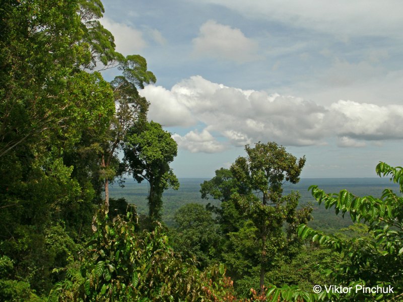
Borneo’s mountain walking is humid, forested, biologically rich, and logistically uneven. The island’s best-known mountain landscapes include the granite massif of Mount Kinabalu, Sarawak’s coastal and limestone mountains, Mulu’s rainforest karst, Brunei’s Temburong hills, and Indonesian Kalimantan’s isolated rock and forest summits. Most accessible day hikes are lower than the famous multi-day summit routes, but they still involve heat, rain, roots, ladders, leeches, and slippery tropical ground.
The normal hiking season is not defined by winter snow but by rainfall, river levels, park rules, and local closures. Rain can fall in any month. Kinabalu Park and Mulu have formal park management, while some Indonesian Kalimantan routes have less standardised English-language route documentation. Public transport can reach major towns and parks, but many trailheads require taxi, park transfer, domestic flight, boat, guide, or local driver logistics.
Mount Kinabalu itself is excluded as a summit day hike because the normal legal route is a controlled overnight climb requiring permits, accommodation, guide arrangements, and an early summit stage. The Kinabalu entry below therefore uses the park-headquarters day-trail network to represent the mountain’s lower montane forest.
Selection rationale
The five hikes cover the island’s key accessible day-walking styles: Kinabalu montane forest, a hard coastal mountain summit at Santubong, Mulu rainforest karst and waterfall walking, Brunei’s Bukit Patoi forest summit, and Indonesian Kalimantan’s Bukit Kelam monolith.
Summary table
| # | Hike | Country | Route type | Distance | Gain | Max elevation | Difficulty |
|---|---|---|---|---|---|---|---|
| 1 | Kinabalu Park Kiau View / Silau-Silau / Liwagu Trail Circuit | Malaysia | Loop / linked nature trails | 5.6-6.4 km | Approx. 250 m | Approx. 1,700 m | Moderate |
| 2 | Mount Santubong Summit Trail | Malaysia | Out-and-back / loop variants | 6.8-8.4 km | 710-780 m | 810 m | Hard |
| 3 | Mulu Paku Valley Loop and Paku Waterfall | Malaysia | Loop | 8 km | Approx. 150 m | Approx. 180 m | Easy-moderate |
| 4 | Bukit Patoi, Peradayan Forest Reserve | Brunei | Out-and-back | 3.2 km | Approx. 200 m | 310 m | Moderate |
| 5 | Bukit Kelam / Gunung Kelam | Indonesia | Out-and-back / local route variants | Approx. 5-8 km | Approx. 850-900 m | 940-1,002 m depending source | Hard |
1. Kinabalu Park Kiau View / Silau-Silau / Liwagu Trail Circuit
Snapshot
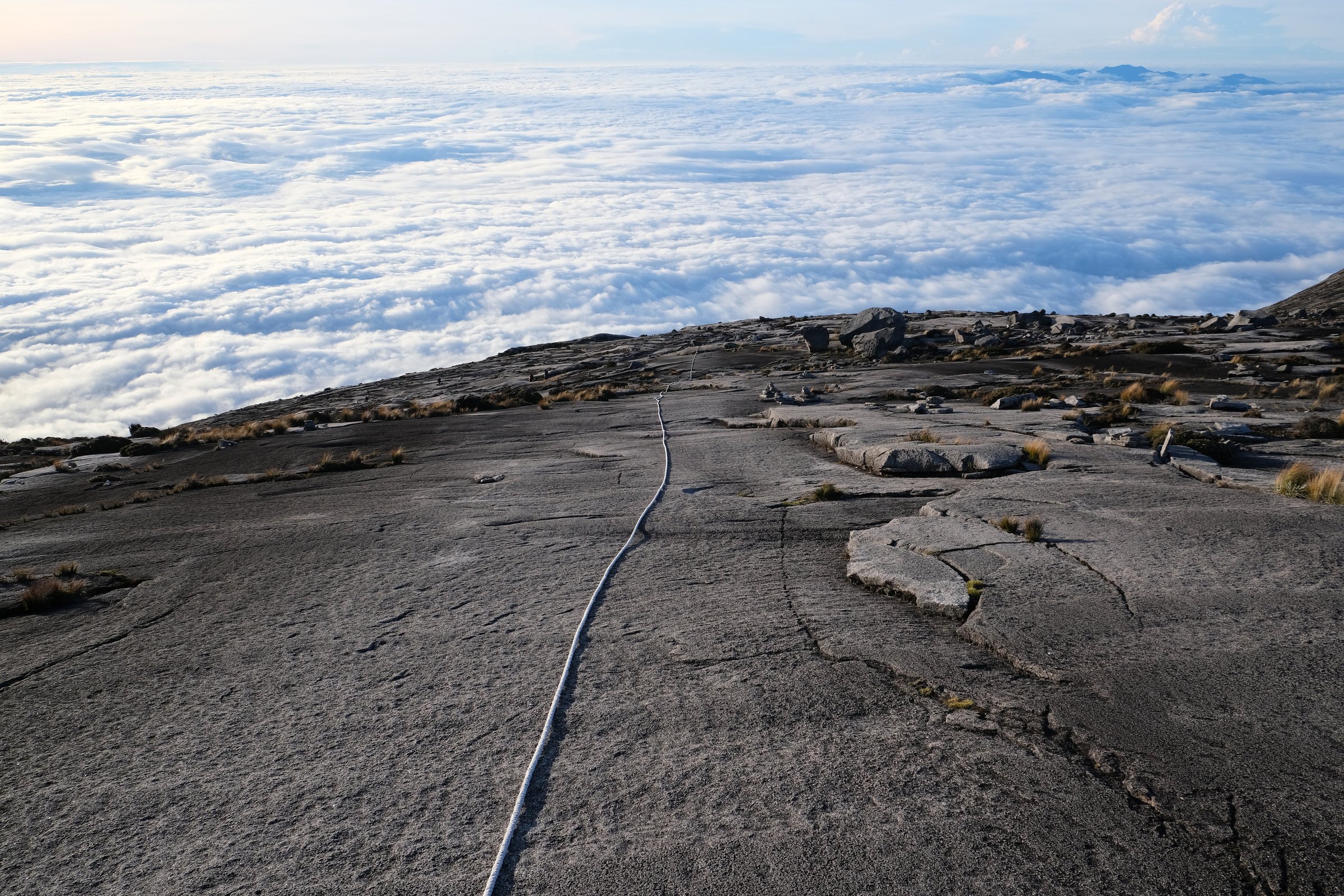
Itinerary
The route links the lower montane trails around Kinabalu Park headquarters. A common day-walk combination uses the Kiau View Trail, Silau-Silau Trail, botanic garden / headquarters paths, and, where open, the Liwagu Trail or parts of it. The walking passes chestnut-oak forest, riverine forest, mossy slopes, and occasional clear views toward Mount Kinabalu.
Trail availability can change after storms or maintenance. The Liwagu Trail is sometimes reported closed by trail databases, so the exact circuit should be checked at the park office before starting.
Why it is essential
This is the most practical day-hike representation of Mount Kinabalu’s lower montane forest for walkers not doing the controlled overnight summit climb. It gives access to the biodiversity that makes Kinabalu Park a World Heritage Site.
Equipment
Standard hiking equipment: walking shoes with good wet grip, rain layer, water, insect protection, sun protection, and a map or park-trail sketch from headquarters.
Hazards and notes
Tropical rain can make steps, roots, and boardwalks slippery. Leeches are possible in wet conditions. Check current trail closures, park entry fees, and the status of Liwagu Trail at headquarters.
GPX / KML links
| Source | URL | Format / access | Reuse status |
|---|---|---|---|
| Wikiloc: Kinabalu Park Silau-Sukau-Botanic Garden-Kiau View Trail | wikiloc.com | Source route / downloadable GPS track via Wikiloc | Wikiloc terms apply; route source found, reuse of file not confirmed |
| Sabah Parks: Kinabalu Park | sabahparks.org.my | Official park context | Website terms apply; no GPX found, official access and park context only |
| OpenStreetMap search: Kinabalu Park Liwagu Trail | openstreetmap.org | Source map | OSM data is ODbL; geometry cross-check only |
External links
- Sabah Parks — Kinabalu Park
- Wikiloc — Kinabalu Park linked-trail route
- MeowtainPeople — Kinabalu National Park day trails
2. Mount Santubong Summit Trail
Snapshot
Itinerary
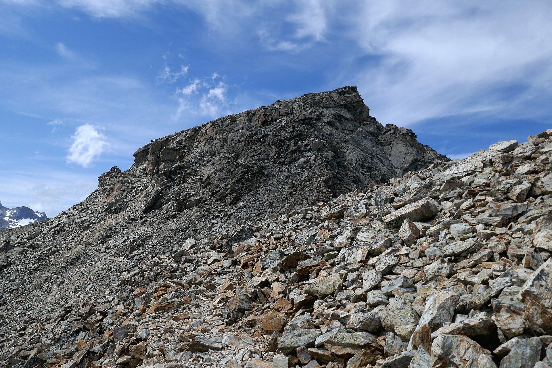
The trail climbs from lowland coastal forest into the steep slopes of Mount Santubong. It passes waterfall and forest sections before reaching steeper root, ladder, rope, and scrambling-assisted ground higher on the mountain. The summit has views over the South China Sea, Santubong coast, mangroves, and river deltas when weather is clear.
The horizontal distance is modest, but the climb is steep and tropical. Sarawak Tourism cites a challenging summit trek taking about 4 hours one way and 8 hours round trip.
Why it is essential
Mount Santubong is the classic hard day summit near Kuching and one of Borneo’s most recognisable coastal mountain hikes. It combines rainforest, steep route-finding, coastal views, and Sarawak cultural geography.
Equipment
Mountain hiking equipment: sturdy shoes or boots with wet-rock grip, gloves for ropes/ladders if desired, rain layer, sun protection, 2-3 litres of water, food, headtorch, and navigation backup.
Hazards and notes
The route is steep, muddy, rooty, and slippery after rain. Ladder and rope sections require upper-body confidence. Registration, park access point, and opening rules should be checked with Sarawak Forestry before departure. Do not start late.
GPX / KML links
| Source | URL | Format / access | Reuse status |
|---|---|---|---|
| AllTrails: Mount Santubong | alltrails.com | Source route / app track | AllTrails terms apply; route source found, route-file reuse not confirmed |
| Wikiloc: Gunung Santubong | wikiloc.com | Source route / downloadable GPS track via Wikiloc | Wikiloc terms apply; route source found, reuse of file not confirmed |
| Sarawak Forestry Corporation: Santubong National Park | sfc.sarawak.gov.my | Official park context | Website terms apply; no GPX found, official access and activity context |
External links
- Sarawak Forestry Corporation — Santubong National Park
- Sarawak Tourism Board — Mount Santubong
- AllTrails — Mount Santubong
3. Mulu Paku Valley Loop and Paku Waterfall
Snapshot
Itinerary
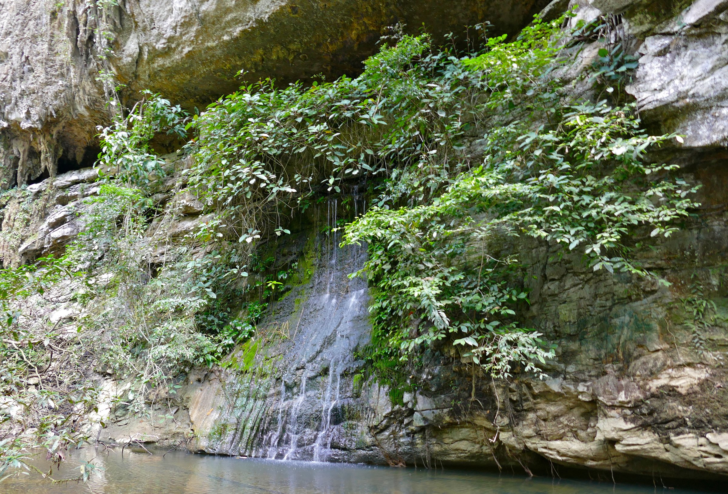
From park headquarters, the Paku Valley Loop leaves the more heavily used cave-walk corridor and follows rainforest paths toward Paku Waterfall and the Paku / Melinau forest environment. The full loop gives a longer self-guided rainforest day than the short boardwalk cave approaches. A shorter version turns back after Paku Waterfall.
The official Mulu page states that the 8 km Paku Valley Loop can be walked independently but hikers should register plans with park security before leaving.
Why it is essential
Mulu is one of Borneo’s iconic mountain-karst landscapes. The Paku Valley Loop is a realistic day hike that samples rainforest, water, and limestone-park ecology without turning the multi-day Pinnacles trek into an artificial day route.
Equipment
Standard tropical hiking equipment: shoes with wet grip, rain protection, water, insect protection, snacks, and a dry bag. A headtorch is useful if combining with cave or bat-observatory timing.
Hazards and notes
Concrete and forest sections can be slippery. Small stream crossings may change quickly after rain. Register at park security before setting out as requested by the official park guidance.
GPX / KML links
| Source | URL | Format / access | Reuse status |
|---|---|---|---|
| Wikiloc: Paku waterfall (Mulu) | wikiloc.com | Source route / downloadable GPS track via Wikiloc | Wikiloc terms apply; route source found, reuse of file not confirmed |
| Mulu Park: Paku Valley Loop or Kenyalang Loop | mulupark.com | Official route page | Website terms apply; no GPX found, official distance and access source |
| OpenStreetMap search: Paku Valley Loop Mulu | openstreetmap.org | Source map | OSM data is ODbL; geometry cross-check only |
External links
4. Bukit Patoi, Peradayan Forest Reserve
Snapshot
Itinerary
The trail climbs and descends through protected forest in Peradayan Forest Reserve to the rocky summit area of Bukit Patoi. The top has an open flat area used as a viewpoint, with views across Temburong, neighbouring Sarawak landscapes, and, in clear weather, toward the coast.
The official Brunei source describes a 1.6 km forest trail that winds up and down the mountainside to the peak, with about an hour up and an hour down.
Why it is essential
Bukit Patoi is Brunei’s most accessible essential forest-summit walk and gives the Borneo set a Temburong rainforest hill route outside Malaysia and Indonesia.
Equipment
Standard hiking equipment: grippy walking shoes, rain layer, water, insect protection, and sun protection. Trekking poles are optional.
Hazards and notes
The route is short but humid and can be slippery after rain. Carry enough water, as Brunei Tourism specifically warns visitors to bring plenty. Respect forest-reserve rules and avoid disturbing wildlife.
GPX / KML links
| Source | URL | Format / access | Reuse status |
|---|---|---|---|
| Wikiloc: Bukit Patoi | wikiloc.com | Source route / downloadable GPS track via Wikiloc | Wikiloc terms apply; route source found, reuse of file not confirmed |
| Brunei official page: Bukit Patoi Forest Recreation Park | fisheries.gov.bn | Official source page | Website terms apply; no GPX found, official distance/elevation/access source |
| OpenStreetMap search: Bukit Patoi | openstreetmap.org | Source map | OSM data is ODbL; geometry cross-check only |
External links
- Brunei Tourism — Bukit Patoi Recreational Park
- Government of Brunei — Bukit Patoi Forest Recreation Park
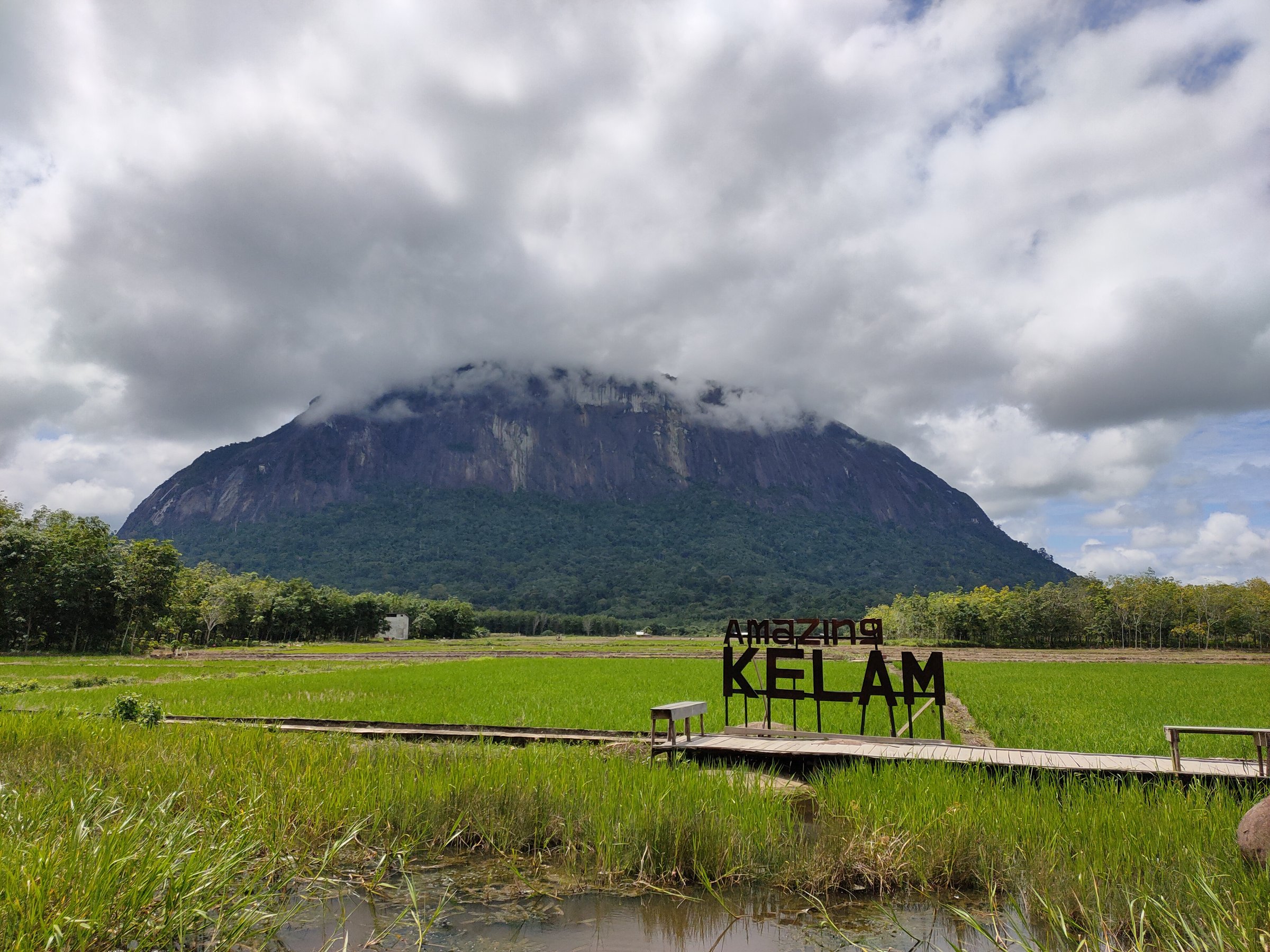
5. Bukit Kelam / Gunung Kelam
Snapshot
Itinerary
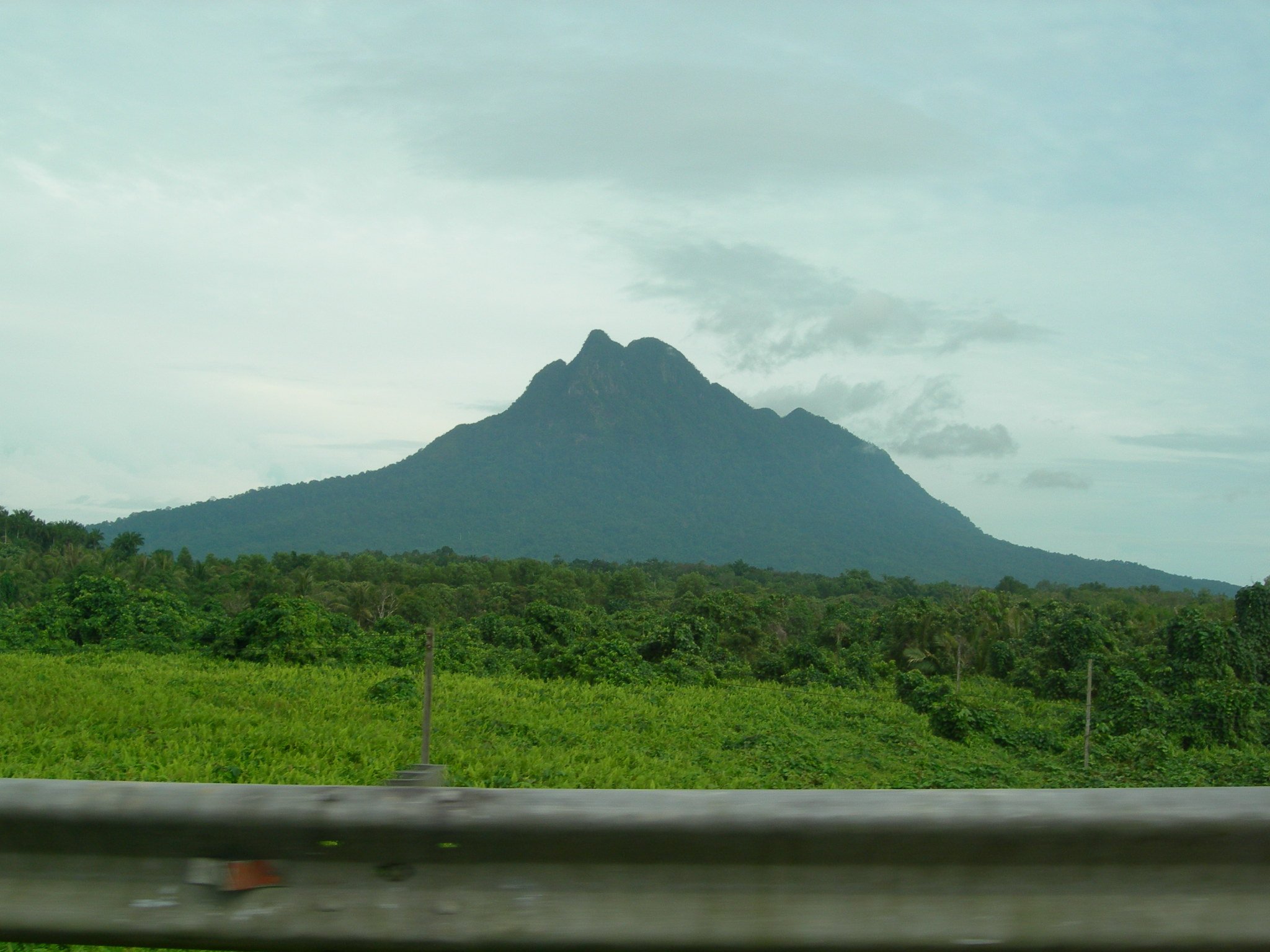
The hike climbs the isolated granitic dome of Bukit Kelam, a landmark rising above the Kapuas and Melawi river landscape near Sintang. Local routes begin near the tourist access area and climb forested, rocky slopes toward upper viewpoints or the summit area. Some sources describe Bukit Kelam as a very large exposed rock hill or monolith, with route conditions that can be steep and serious.
Exact route statistics remain weak in English-language sources. The route should be treated as a local guided or locally confirmed hike rather than a standard signposted international trail.
Why it is essential
Bukit Kelam gives the catalogue an Indonesian Kalimantan mountain objective and one of Borneo’s most distinctive isolated rock summits. It broadens the Borneo selection beyond Sabah, Sarawak, and Brunei.
Equipment
Mountain hiking equipment: boots or very grippy shoes, rain layer, sun protection, at least 2-3 litres of water, food, headtorch, and navigation backup. A local guide or current local route advice is recommended.
Hazards and notes
Steep rock, wet forest, heat, route ambiguity, and limited rescue access are the main concerns. Check current local access, fees, route condition, and whether the summit route is open before departure.
GPX / KML links
| Source | URL | Format / access | Reuse status |
|---|---|---|---|
| OpenStreetMap search: Bukit Kelam | openstreetmap.org | Source map | OSM data is ODbL; geometry cross-check only |
| Gunung Bagging: Kelam | gunungbagging.com | Source page | Site terms apply; no GPX licence found, route and elevation context only |
| Agroberichten Buitenland: Bukit Kelam tourism development | agroberichtenbuitenland.nl | Source page | Site terms apply; no route file, location/elevation/tourism context only |