Regional overview
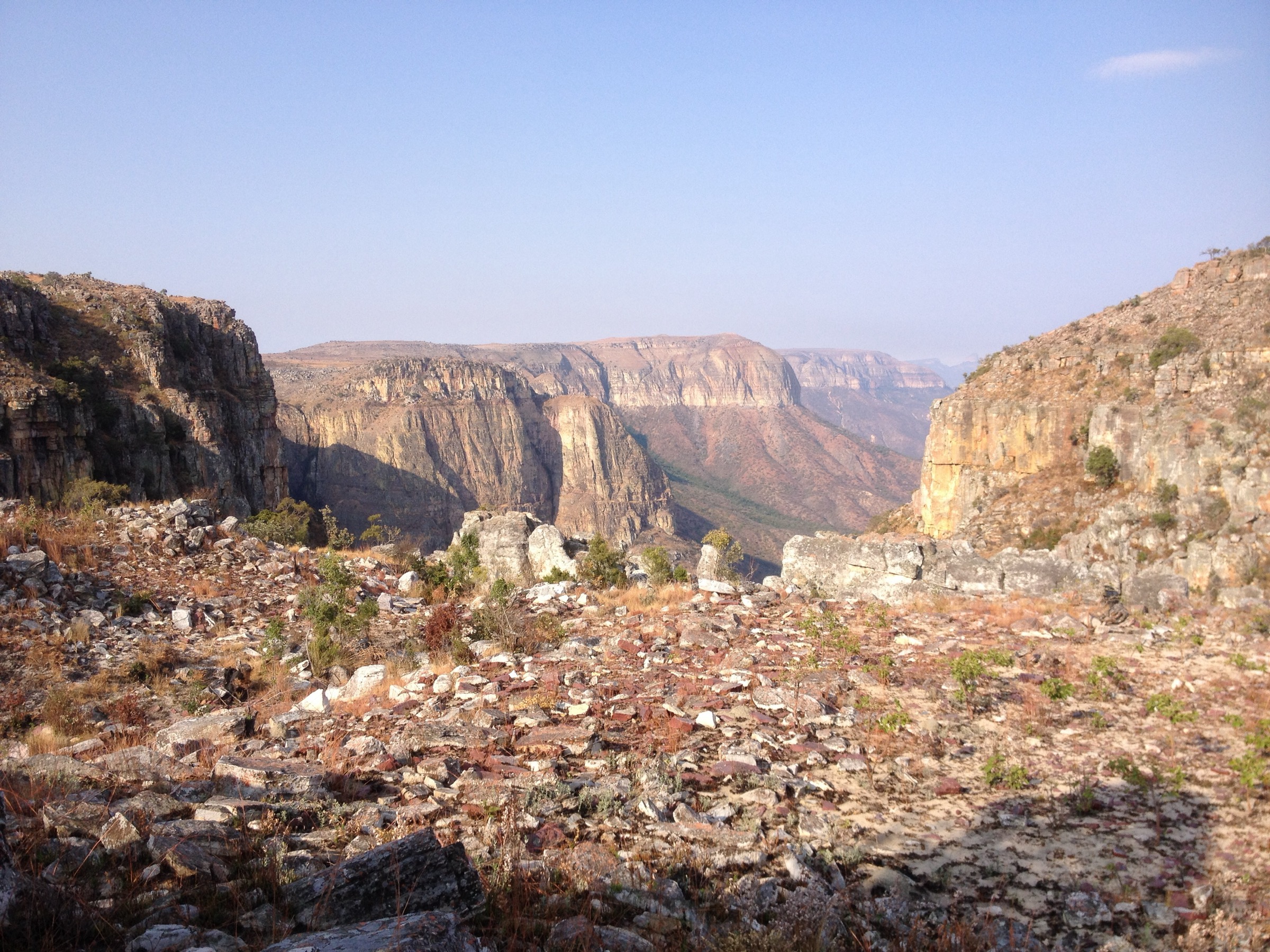
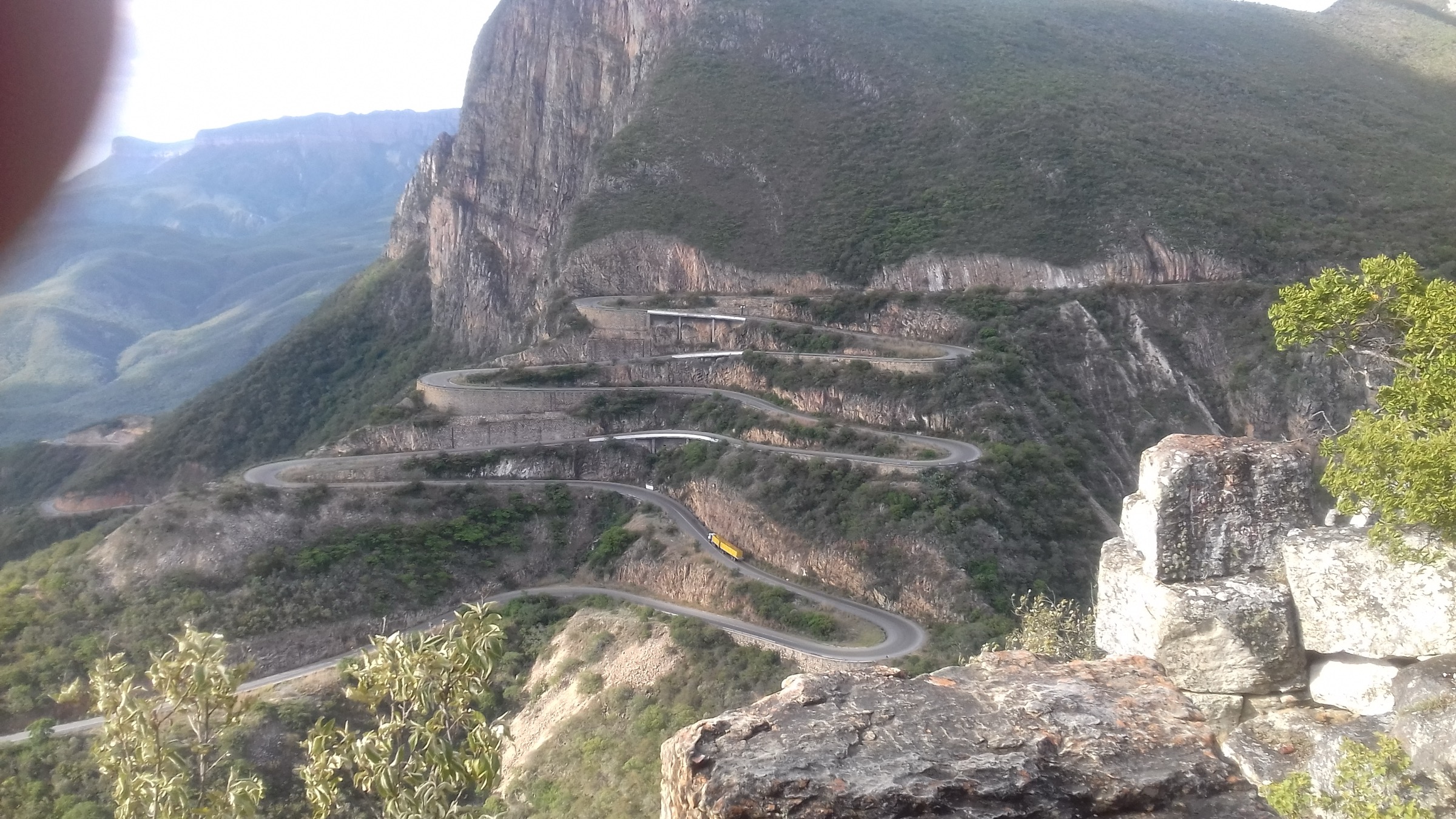
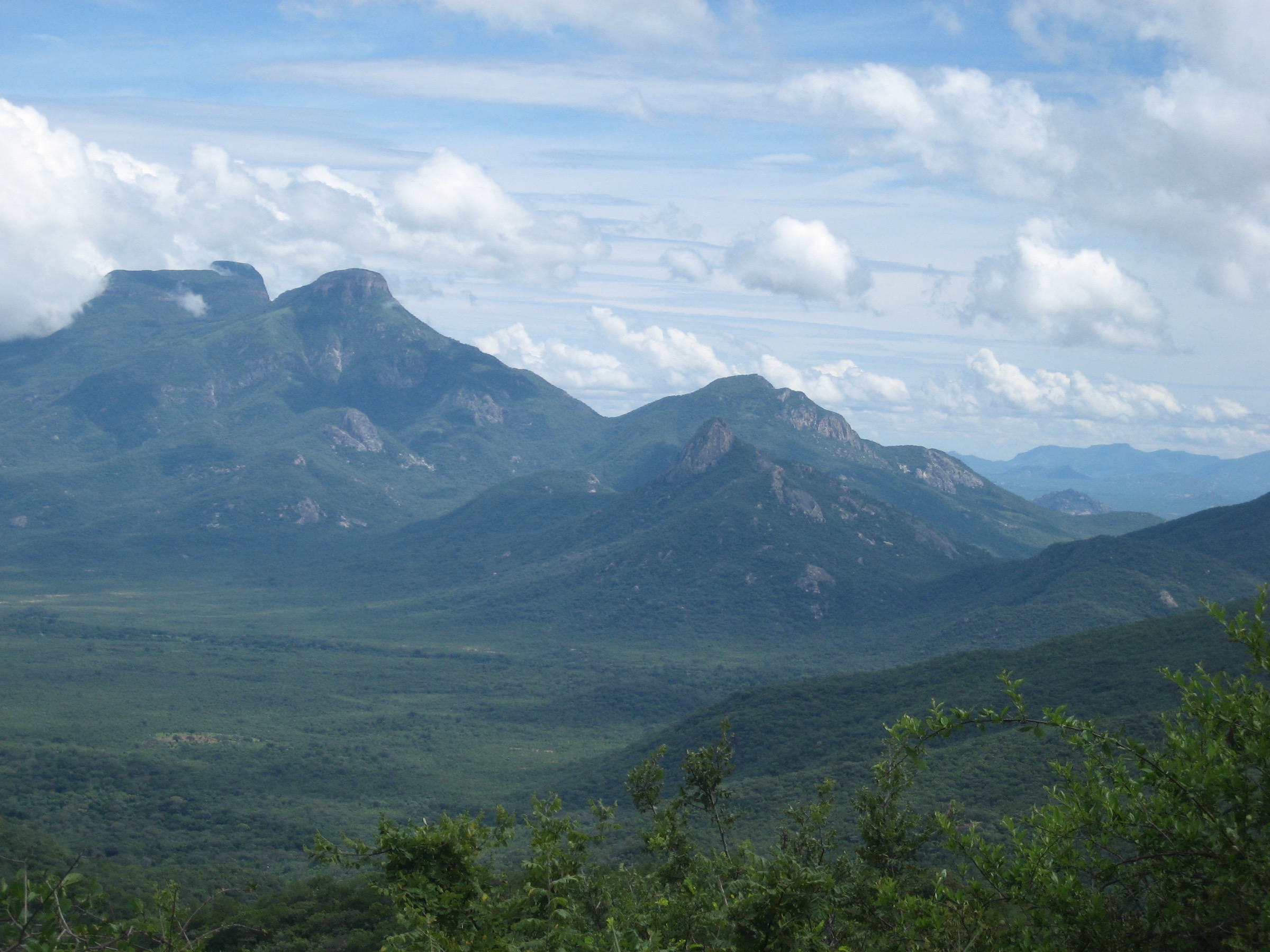
The Serra da Leba is the southwestern edge of the Angolan central plateau, where the Humpata Plateau breaks off in a near-vertical escarpment toward the Namibe coastal lowlands. It is an extension of the Serra da Chela range, lying between Huíla Province on the plateau and Namibe Province below, about 30 km west of Lubango. The plateau rim sits at roughly 1,840 m and the foot of the escarpment near Bruco at roughly 830 m, giving a drop of about 1,000 m over a horizontal distance of only a few kilometres. The defining feature is the EN-280 Leba pass road, a Portuguese colonial engineering project begun in 1969 and opened in the early 1970s, which descends about 1,000 m in less than 10 km of road distance through a famous tight sequence of hairpin curves. The road appears on the back of the 2,000-kwanza banknote and is one of the most photographed landscapes in the country.
Geologically the escarpment exposes the Chela Group, a Paleo-to-Mesoproterozoic volcano-sedimentary sequence whose Bruco and Humpata formations build the plateau itself, capped by tabular Cunene anorthositic intrusives. The viewpoint above the switchbacks sits at about 1,680 m on the northwestern face of the escarpment. To the east the Humpata Plateau stretches inland toward Lubango; to the south and north the same rim continues for tens of kilometres as a near-continuous cliff line, partly cut by the Sondjo and Caculuvar drainages, which fall toward the Namibe peneplain in seasonal waterfalls. The 2024 Land geoheritage study by Jorge and co-authors inventoried 13 geosites along the EN-280 corridor, formalising the road as a geotourism route.
Walking infrastructure is minimal. There are no marked national-park trails of the European or East African type, no published trailhead signage, and no recognised mountain-rescue service. Most actual walking is on the road itself or on informal tracks from the rim toward the communication masts and the small viewpoint above the topmost hairpin. The Cascata da Leba (Leba Waterfalls), administered from Humpata as a B-rated tourism site, is the only feature in the area with a formal opening schedule. Visit Huíla lists it as open 07:00–17:00.
Two safety issues dominate this region in addition to standard exposure. The first is landmine and unexploded-ordnance contamination from the 1975–2002 civil war: although Angola declared most of nine provinces mostly cleared in March 2025, Huíla was still under active HALO Trust survey, and walkers must not leave roads, tracks or signed paths without local guidance. The second is the EN-280 road itself, which is heavily used by trucks crossing between Namibe port and the interior; walkers on or near the carriageway must factor in heavy goods vehicles on steep gradients with limited sight lines. Malaria prophylaxis is required below about 1,500 m; the escarpment foot at Bruco and the Namibe lowlands are high-risk.
This entry covers the escarpment edge, the EN-280 pass, the Cascata da Leba and the immediate Bruco approach. Tundavala Gap, Cristo Rei do Lubango and the wider Huíla Highlands plateau north of Lubango are catalogued separately in the Huíla Highlands entry, and the central Angolan plateau is covered in the Bié Plateau entry.
Selection rationale
The five entries cover the defining landscape types of the Serra da Leba: an iconic viewpoint walk above the switchbacks, two rim walks south and north of the pass for escarpment-edge character, a historic-route walk on the colonial Leba road itself, and a waterfall objective in the side valleys feeding the Sondjo drainage. A base-to-rim traverse from Bruco was considered but is left as a candidate research target rather than a verified route. Cristo Rei and Tundavala are explicitly excluded as they belong to the Huíla Highlands plateau article.
Summary table
| # | Hike | Country | Route type | Distance | Gain | Max elevation | Difficulty |
|---|---|---|---|---|---|---|---|
| 1 | Miradouro da Leba viewpoint walk | Angola | Short out-and-back from EN-280 to the mast viewpoint | ~1.5-2 km return | ~30-50 m | ~1,720 m (mast knoll) | Easy |
| 2 | Chela escarpment rim walk south of Leba pass | Angola | Candidate rim traverse from the EN-280 toll south along the cliff | Unresolved (~6-10 km est.) | Modest | ~1,840 m | Candidate only |
| 3 | EN-280 historic Leba road walk (top six hairpins) | Angola | Point-to-point or out-and-back on the colonial pass road | ~6-8 km one way (top section) | ~600 m descent | ~1,845 m (rim) | Moderate |
| 4 | Cascata da Leba waterfall walk | Angola | Short out-and-back to a multi-tier waterfall | Short; figures unresolved | Modest | ~1,700 m order of magnitude | Easy-moderate |
| 5 | Bruco escarpment-foot approach to the Leba switchbacks | Angola | Candidate base-to-rim approach from the Namibe side | Unresolved | ~1,000 m to rim | ~1,845 m (rim) | Candidate only |
1. Miradouro da Leba viewpoint walk
Snapshot
Itinerary
From the EN-280 toll and security barrier at the top of the pass, an informal vehicle track turns south (left when ascending from Namibe) and runs across rolling moorland toward a cluster of communication masts on the rim. From the masts, a short footpath continues to the cliff edge where the topmost hairpins of the EN-280 lie directly below. The viewpoint, formally named the Miradouro da Leba, sits at approximately 1,680 m on the northwestern face of the escarpment and faces the steepest part of the road. To the east the Humpata Plateau extends inland; to the southwest the Sondjo River gorge cuts down toward the Namibe peneplain in a series of waterfalls. Most visitors return to the EN-280 by the same track.
Why it is essential
This is the defining short walk of the Chela escarpment and the standard photographic objective on every trip across the pass. The view down the upper hairpins is the image used on the 2,000-kwanza banknote and is a recognised national geoheritage geosite. As a 30-60 minute outing it pairs with any road journey between Lubango and Namibe and acts as the orientation walk for the rest of the region.
Equipment
Standard hiking equipment: grippy footwear, sun protection, water, light wind layer for the rim. No technical equipment is required, but the cliff edge is unfenced and a head for heights is essential.
Hazards and notes
- Persistent landmine and UXO risk in rural Angola; Huíla Province was still under active HALO Trust survey as of 2025. Do not leave the vehicle track or beaten footpaths without a local guide who can confirm clearance.
- No formal mountain rescue infrastructure; the nearest hospital is in Lubango.
- Extreme exposure at the cliff edge; falls are unforgiving and the rim has no protective railings.
- Traffic on EN-280: the pass road is heavily used by trucks crossing between Namibe port and the interior, with limited sight lines on the upper hairpins.
- Malaria prophylaxis required below ~1,500 m; the escarpment foot near Bruco is high-risk.
GPX / route file
| Source | URL | Format / access | Reuse status |
|---|---|---|---|
| OpenStreetMap — Miradouro da Leba | openstreetmap.org | Source map / location | OSM data is ODbL; not a route file |
| Wikiloc search — Serra da Leba | wikiloc.com | Search page | Wikiloc terms apply if a track is later selected; no GPX selected here |
External links
- Jorge et al. (2024) — Geoheritage of the Iconic EN280 Leba Road, Land 13(8):1293
- Visit Huíla — Miradouro da Leba (Humpata)
- U.S. Department of State Angola Travel Advisory, 5 March 2026 (Level 2)
2. Chela escarpment rim walk south of Leba pass
Snapshot
Itinerary
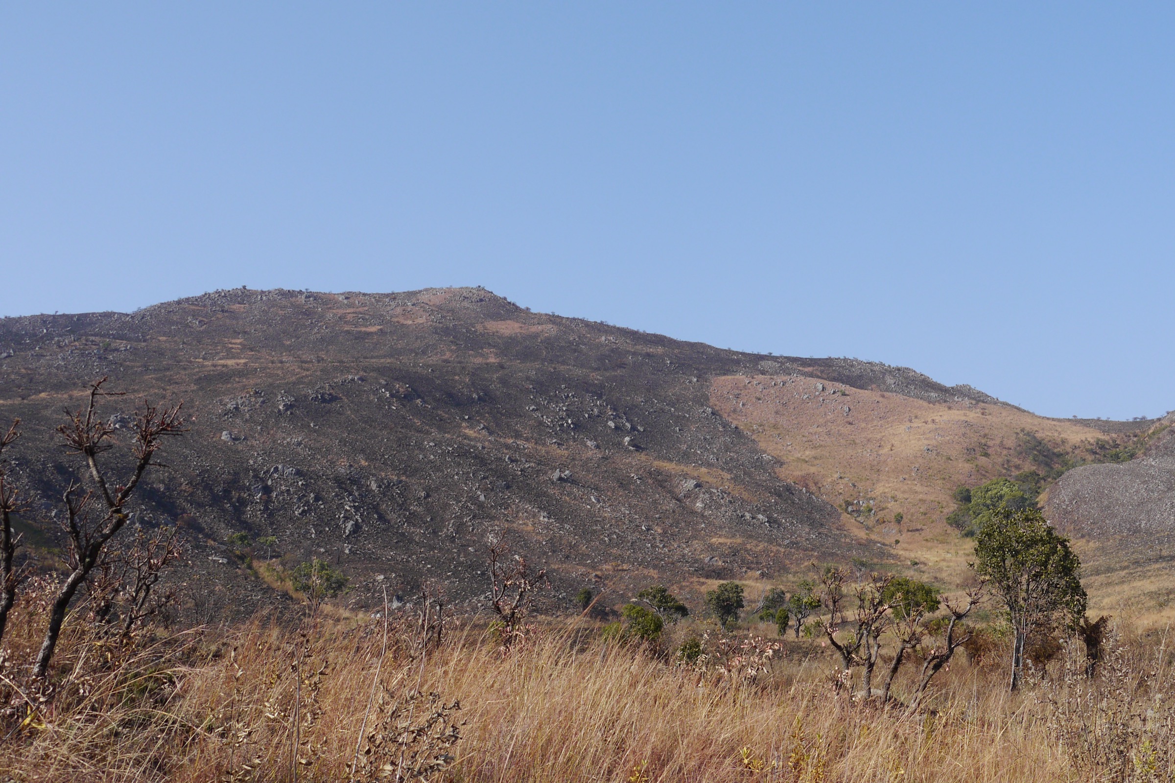
South of the EN-280 toll the Humpata Plateau continues at about 1,800-1,840 m as rolling moorland with scattered farms and cattle posts, ending abruptly at the same escarpment that the road descends. Informal farm tracks run more or less parallel to the cliff edge for several kilometres before petering out into open ground. No standardised, publicly described route, distance or turnaround point exists for this catalogue; the entry is offered as a research target for walkers with a local guide and confirmed clearance status from HALO Trust or local authorities. The rim faces west over the Sondjo drainage and the Namibe peneplain.
Why it is essential
This is the most direct way to experience the Chela escarpment as a continuous landscape rather than a single viewpoint — the cliff line south of the pass is unbroken for tens of kilometres and offers the same 1,000 m drop without the road traffic of the EN-280. A documented rim walk here would balance the Miradouro viewpoint and the historic-road walk by adding a true escarpment-edge traverse.
Equipment
Mountain hiking equipment: sturdy boots, navigation backup (paper map plus GPS — there is no marked path), full sun and wind protection, plenty of water (no surface water at the rim in dry season), and a local guide. Mobile coverage along the rim is limited.
Hazards and notes
- Persistent landmine and UXO risk in rural Angola; Huíla Province remained under active HALO Trust survey in 2025. The rim south of the pass has no published clearance certification and must not be walked without a local guide who can confirm safe ground.
- No formal mountain rescue infrastructure; self-evacuation to EN-280 in case of injury.
- Extreme exposure on the escarpment edge; the cliff line is unprotected and partly hidden by tall grass.
- Traffic on EN-280: shuttle drop-off and pick-up at the toll involves walking the carriageway briefly; heavy truck traffic on steep gradients.
- Malaria prophylaxis required below ~1,500 m; the foot of the escarpment is high-risk.
GPX / route file
| Source | URL | Format / access | Reuse status |
|---|---|---|---|
| OpenStreetMap — Serra da Leba area | openstreetmap.org | Source map | OSM data is ODbL; not a route file |
| Wikiloc search — Chela rim | wikiloc.com | Search page | No GPX selected; entry is a research target |
External links
- Wikivoyage — Great Escarpment (Angola)
- Jorge et al. (2024) — Geoheritage of the Iconic EN280 Leba Road, Land 13(8):1293
- HALO Trust — Angola programme
- U.S. Department of State Angola Travel Advisory, 5 March 2026 (Level 2)
3. EN-280 historic Leba road walk (top six hairpins)
Snapshot
Itinerary
From the EN-280 toll at the pass, the route follows the carriageway downhill on the Namibe side through the famous tight sequence of hairpin curves. Engineering sources put the road’s overall ascent at about 1,845 m in less than 30 km, with gradients reaching 34% in places and at least twelve near-180-degree hairpins, of which six lie on the most picturesque top section directly below the Miradouro. The walk descends those upper six hairpins on tarmac, with the option to cut between successive switchback levels on short pedestrian shortcuts where they are obvious and clearly not on a private cattle path. Turnaround can be at any hairpin where the road levels briefly; a common pick-up point is the foot of the upper sequence at about 1,200-1,300 m, where an arranged vehicle from Lubango or Namibe can rejoin the walkers.
Why it is essential
The EN-280 itself is the cultural and engineering centrepiece of the Serra da Leba — a colonial-era road of considerable historical importance, the cover image of the 2,000-kwanza banknote and a recognised national geosite. Walking the top hairpins gives a continuously shifting perspective on the escarpment that the road-bound viewpoint cannot match, and exposes the rapid change in vegetation from plateau grassland through cloud forest to drier escarpment slopes.
Equipment
Standard hiking equipment: grippy footwear, sun protection, water, light wind layer for the rim and a high-visibility outer layer for road walking. Trekking poles helpful for the descent. A pre-arranged pick-up vehicle is strongly recommended rather than a long return on foot.
Hazards and notes
- Persistent landmine and UXO risk in rural Angola; the road verge itself is generally safe but the immediate slopes off the road have no published clearance certification — do not leave the carriageway.
- No formal mountain rescue infrastructure; the nearest hospital is in Lubango.
- Extreme exposure on the escarpment edge; the outer side of the road has only a low parapet in places and no parapet at all in others.
- Traffic on EN-280: heavy truck traffic on steep gradients with limited sight lines on the upper hairpins. Walkers should keep to the inside (uphill) verge facing oncoming traffic, wear high-visibility clothing and avoid the road in early-morning mist or after dark.
- Malaria prophylaxis required below ~1,500 m; the lower hairpins approach this threshold.
GPX / route file
| Source | URL | Format / access | Reuse status |
|---|---|---|---|
| OpenStreetMap — EN-280 Serra da Leba road | openstreetmap.org | Source map / road geometry | OSM data is ODbL; not a route file |
| Wikiloc search — EN-280 Leba | wikiloc.com | Search page | Wikiloc terms apply if a track is later selected; no GPX selected here |
External links
- Jorge et al. (2024) — Geoheritage of the Iconic EN280 Leba Road, Land 13(8):1293
- Wikipedia — Serra da Leba
- Dangerous Roads — Serra da Leba pass
- U.S. Department of State Angola Travel Advisory, 5 March 2026 (Level 2)
4. Cascata da Leba waterfall walk
Snapshot
Itinerary
Tourism sources put the Cascata da Leba about 19 km from the Humpata administrative centre. The waterfall is a multi-tier cascade where a small plateau stream gathers volume and drops across the same Chela Group sandstones that build the escarpment, ending in a pool used informally for bathing. From the parking area an informal path threads between cliff ledges to the lower pool. Visit Huíla lists the site as open 07:00–17:00 and rates it as a B-category attraction. Most visitors return to the parking area by the same path.
Why it is essential
The Cascata da Leba is the most accessible documented waterfall on the Chela escarpment edge and the only objective in this catalogue with formally published opening hours. It complements the road and viewpoint entries by showing the escarpment from inside one of the drainages that cuts through it, rather than only from the rim. Tourism marketing material describes it as one of the best-kept secrets of the region.
Equipment
Standard hiking equipment: grippy footwear, sun and rain protection, water and swimwear if planning to bathe. A local guide arranged at Humpata is recommended for the descent path, which is informal and not signposted.
Hazards and notes
- Persistent landmine and UXO risk in rural Angola; Huíla Province remained under active HALO Trust survey in 2025. Stay on the established path and do not enter open ground without a local guide.
- No formal mountain rescue infrastructure.
- Extreme exposure: the route runs between cliff ledges with no protection; falls from the upper ledges would be unforgiving.
- Traffic on the access roads to Humpata is local but the connection to EN-280 carries heavy truck traffic.
- Malaria prophylaxis required below ~1,500 m; the waterfall pool sits below that threshold in seasonal terms.
- Opening hours and any entry fee should be confirmed at Humpata administration on the day.
GPX / route file
| Source | URL | Format / access | Reuse status |
|---|---|---|---|
| OpenStreetMap search — Cascata da Leba | openstreetmap.org | Source map / search | OSM data is ODbL; not a route file |
| Wikiloc search — Cascata Leba | wikiloc.com | Search page | No GPX selected here |
External links
- Visit Huíla — Cascata da Leba (Humpata)
- Hotéis Angola — Cascata da Leba
- U.S. Department of State Angola Travel Advisory, 5 March 2026 (Level 2)
5. Bruco escarpment-foot approach to the Leba switchbacks
Snapshot
Itinerary
This is a candidate base-to-rim route from the Bruco area at the escarpment foot up to the EN-280 toll on the rim, gaining about 1,000 m of elevation through the same cloud-forest belt that the road’s upper hairpins cross. No standardised, publicly described trail, distance or ascent figure exists; the entry is offered as a research target for walkers with a local guide and confirmed clearance status. In practice the realistic line is likely to combine local foot tracks below Bruco with sections of the EN-280 carriageway through the hairpins themselves. The reverse direction (rim to base) is also feasible and avoids the heat of the lower escarpment in afternoon sun.
Why it is essential
A documented base-to-rim traverse would round out the regional picture by adding the only entry that crosses the full 1,000 m drop of the Chela escarpment on foot. It would also be the only entry that combines the Huíla plateau, the colonial road and the Namibe lowlands in a single walk.
Equipment
Mountain hiking equipment: sturdy boots, navigation backup, full sun, heat and wind protection, large water capacity (no reliable surface water on the lower escarpment in dry season), headtorch for early starts or late finishes, and a local guide. Mobile coverage on the lower escarpment is limited.
Hazards and notes
- Persistent landmine and UXO risk in rural Angola; both the Namibe lowlands at Bruco and the slopes immediately off EN-280 lack published clearance certification. Do not walk this line without a local guide who can confirm safe ground.
- No formal mountain rescue infrastructure; self-evacuation by EN-280 in case of injury.
- Extreme exposure on the escarpment edge near the rim; the cliff line is unprotected.
- Traffic on EN-280: any line that uses the carriageway through the hairpins shares heavy truck traffic on steep gradients. Walk against oncoming traffic and wear high-visibility clothing.
- Malaria prophylaxis required below ~1,500 m; the Namibe lowlands at Bruco are high-risk.
- Heat illness risk on the lower escarpment is significant in summer.
GPX / route file
| Source | URL | Format / access | Reuse status |
|---|---|---|---|
| OpenStreetMap — Bruco / EN-280 lower escarpment | openstreetmap.org | Source map / location | OSM data is ODbL; not a route file |
| Wikiloc search — Bruco Leba | wikiloc.com | Search page | No GPX selected; entry is a research target |
External links
- Jorge et al. (2024) — Geoheritage of the Iconic EN280 Leba Road, Land 13(8):1293
- Wikipedia — Serra da Leba
- HALO Trust — Angola programme
- U.S. Department of State Angola Travel Advisory, 5 March 2026 (Level 2)
Missing data / follow-up work
- Miradouro da Leba walking statistics (distance, gain) are estimated; the viewpoint location and elevation are sourced from the 2024 Land geoheritage paper.
- Chela escarpment rim walk south of the pass remains a candidate target only; no published route, distance or trip report was located.
- EN-280 historic road walk distances and turnaround points are based on the published road profile (1,845 m ascent over <30 km, twelve hairpins, six on the upper section) rather than a signed walking-distance table.
- Cascata da Leba walking statistics are not publicly published; the entry is labelled Partially verified pending verified distance and gain figures.
- Bruco-to-rim traverse has no standardised public day-hike route; the entry remains a research target only.
- No licence-compatible photo was located specifically for the Cascata da Leba, the southern rim, or the Bruco-side approach; regional / representative images are used for those entries with explicit disclosure in the figcaption.
- All published route geometry in this catalogue is referenced via OpenStreetMap and search portals; no third-party tracks have been re-hosted.
- Tundavala Gap and Cristo Rei do Lubango are catalogued in the Huíla Highlands entry; readers expecting them under “Serra da Leba” should follow that cross-reference.
- Landmine and UXO clearance status for individual walking lines around the Serra da Leba should be confirmed directly with HALO Trust or local authorities before walking. As of March 2025 Angola reported that landmines in nine provinces had mostly been eliminated, but Huíla and Namibe were still under active survey.
- Angola is under a U.S. “Exercise Increased Caution” (Level 2) advisory as of 5 March 2026, with specific note of landmine and crime risk; conditions should be re-checked before travel.
External links
| Resource | Link |
|---|---|
| Wikipedia — Serra da Leba | en.wikipedia.org |
| Wikipedia — Tundavala Gap | en.wikipedia.org |
| Wikivoyage — Great Escarpment (Angola) | en.wikivoyage.org |
| Jorge et al. (2024) — Geoheritage of the Iconic EN280 Leba Road, Land 13(8):1293 | mdpi.com |
| Visit Huíla — Miradouro da Leba | visitehuila.com |
| Visit Huíla — Cascata da Leba | visitehuila.com |
| Hotéis Angola — Cascata da Leba | hoteisangola.com |
| Dangerous Roads — Serra da Leba pass | dangerousroads.org |
| HALO Trust — Angola programme | halotrust.org |
| Wikimedia Commons — Serra da Leba category | commons.wikimedia.org |
| U.S. Department of State Angola Travel Advisory, 5 March 2026 (Level 2) | travel.state.gov |