Regional overview
The Huíla Highlands form the southern extension of the Angolan Central Plateau, rising around the city of Lubango — capital of Huíla Province and Angola’s second-largest urban centre — to a high point of about 2,300 m on the Humpata sub-plateau before breaking abruptly off the Serra da Chela escarpment and dropping roughly 1,000 m to the Namibe coastal desert. The result is one of southern Africa’s most dramatic edges: a cool, dolomitic high-savanna country of dambos, miombo woodland and karstic ridges, set at about 1,700-2,300 m, terminating in a near-vertical cliff line studded with named overlooks — Tundavala, Bimbe, and the Serra da Leba pass, the last of which is treated in a sibling article.
Lubango sits on the Humpata Plateau, the dominant hiking base, with the smaller settlements of Humpata and Chibia spread along the plateau to the south. The walking character is mostly short rim and viewpoint walks, plateau dambo strolls, and a handful of urban-edge ascents — Cristo Rei do Lubango above the city is the most obvious. Long route documentation in formats compatible with western trail databases is sparse: Angolan tourism portals such as the Huíla provincial site Visit Huíla and Visit Angola list the destinations but rarely publish trail statistics, and the OpenStreetMap network across the plateau is still thin. Several of the entries below are therefore “Partially verified” or “Candidate only”.
Two essential safety contexts shape the region. First, Angola remains contaminated by landmines and unexploded ordnance from the 1975-2002 civil war; the HALO Trust continues clearance operations primarily in Bié, Huambo, Benguela, Kuando Kubango and (to a lesser extent) Huíla Province, with survey work flagged for Namibe. Off-trail walking on the Huíla and Namibe Province escarpments and bush is not safe without local advice. Second, the Chela escarpment edge is dangerous: the Tundavala rim has no protective railing, and falls from the viewpoint have been documented in the Angolan and Portuguese-language press. Mountain-rescue infrastructure is essentially absent in this part of Angola.
The U.S. Department of State issued a Level 2 (“Exercise Increased Caution”) travel advisory for Angola on 5 March 2026, citing crime, health risks, civil unrest and landmines, with a higher concern for the Luanda metropolitan area. Huíla is not specifically restricted, but rural Huíla and adjacent Namibe Province carry the country’s standard landmine warning. Malarial prophylaxis is required below ~1,500 m (notably the Namibe descent and lower river valleys); the plateau itself is at lower risk because of altitude.
The Serra da Leba pass, its switchback overlooks and the EN280 road itself are catalogued separately in the Serra da Leba / Chela Escarpment article, and the central Angolan plateau around Huambo and the Bié Plateau is covered in its own sibling entry. This article focuses on the Huíla plateau walks, the Tundavala edge, and one isolated summit candidate (Serra da Neve) on the Namibe side of the escarpment.
Selection rationale
The five entries are chosen to span the defining landscape types of the Huíla Highlands: the iconic Chela escarpment viewpoint (Tundavala), the urban-edge cultural and devotional walk (Cristo Rei do Lubango), a second, less-developed plateau-edge canyon (Fenda do Bimbe in Humpata), a plateau interior dambo / savanna walk to show the highland surface itself, and a candidate isolated summit (Serra da Neve in Namibe Province) included to flag the highest verifiable objective associated with the southern Angolan highlands. Where good route data is missing, this is stated explicitly rather than invented.
Summary table
| # | Hike | Country | Route type | Distance | Gain | Max elevation | Difficulty |
|---|---|---|---|---|---|---|---|
| 1 | Tundavala Gap rim walk | Angola | Short rim walk and viewpoint loop | ~2-4 km | Minor | ~2,200 m | Easy (with severe exposure) |
| 2 | Cristo Rei do Lubango walk | Angola | Urban-edge out-and-back to the statue | ~3-5 km return from central Lubango | ~200-300 m | ~2,130 m | Easy-moderate |
| 3 | Fenda do Bimbe (Humpata) viewpoint walk | Angola | Short access walk to a plateau-edge canyon | Short, figures unresolved | Modest | ~2,300 m | Easy-moderate; remote access |
| 4 | Huíla plateau dambo walk near Humpata | Angola | Short interior plateau walk on savanna and dambo terrain | Unresolved | Minor | ~1,800-2,000 m | Easy; Candidate only |
| 5 | Serra da Neve approach (Namibe Province) | Angola | Candidate approach to Angola’s second-highest peak | Unresolved | Unresolved | ~2,489 m (cited summit) | Candidate only |
1. Tundavala Gap rim walk
Snapshot
Itinerary
The sealed access road runs roughly 18 km northwest from central Lubango across the Humpata Plateau to a parking area at the rim of the Serra da Chela escarpment, the western edge of the Huíla Plateau. From the car park, a network of informal paths fans out across the bare dolomitic rim to a series of viewpoints, the most-photographed of which faces a vertical drop of about 1,000 m into the Namibe lowlands, with around 10,000 km² of country visible toward Moçâmedes. A short walk south along the rim leads to a second viewpoint above the gap itself — the natural fissure that gives the site its Nyaneka name, “Ntandavala”, meaning “the aperture”. Most visitors complete a 2-4 km informal loop along the rim and return to the car park. The site was officially designated a cultural landscape by the Angolan government on 21 August 2012 and is listed among Angola’s “Seven Natural Wonders”.
Why it is essential
Tundavala is the defining viewpoint of the Huíla Highlands and the most iconic single image of the Angolan Central Plateau’s southern edge. The 1,000 m drop from the dolomitic Humpata cap rock to the Namibe plain is one of the longest single escarpment falls in the Great Escarpment of southern Africa, and the site is repeatedly listed as the headline attraction of Huíla Province by Visit Angola, the regional Visit Huíla portal and academic geoheritage reviews of the Lubango-Tundavala road traverse.
Equipment
Standard hiking equipment: grippy footwear, sun protection (the rim is exposed and at altitude), water, a warm layer for sunset visits, and a windproof. No technical kit is required. A local guide is not strictly necessary but is useful to identify the safer viewing positions.
Hazards and notes
- The Tundavala rim has no protective railing; falls from the viewpoint have been reported in the Angolan and Portuguese-language press. Stay well back from the edge, particularly in wind or in low light.
- Persistent landmine risk in rural Huíla and adjacent Namibe Provinces. Stay on established tracks and the paved road; verify HALO Trust district clearance status before any off-trail walking.
- Civil-war-era unexploded ordnance contamination remains a documented hazard in rural Angola.
- No formal mountain-rescue infrastructure; evacuation from the escarpment edge would be slow and improvised.
- Malarial prophylaxis required if descending below ~1,500 m on either side of the escarpment; the rim itself, at ~2,200 m, is at lower risk.
- Petty theft has been reported at quieter viewpoints; avoid leaving valuables visible in vehicles.
GPX / KML links
| Source | URL | Format / access | Reuse status |
|---|---|---|---|
| OpenStreetMap — Tundavala Gap location | openstreetmap.org | Source map / location | OSM data is ODbL; not a route file |
| Wikiloc search — Tundavala | wikiloc.com | Search page | Wikiloc terms apply if a track is later selected; no GPX selected here |
External links
- Wikipedia — Tundavala Gap
- Visit Huíla — Tundavala
- Geoheritage of the Lubango-Tundavala road traverse — ScienceDirect (Cardoso et al.)
- U.S. Department of State Angola Travel Advisory, 5 March 2026
2. Cristo Rei do Lubango walk
Snapshot
Itinerary
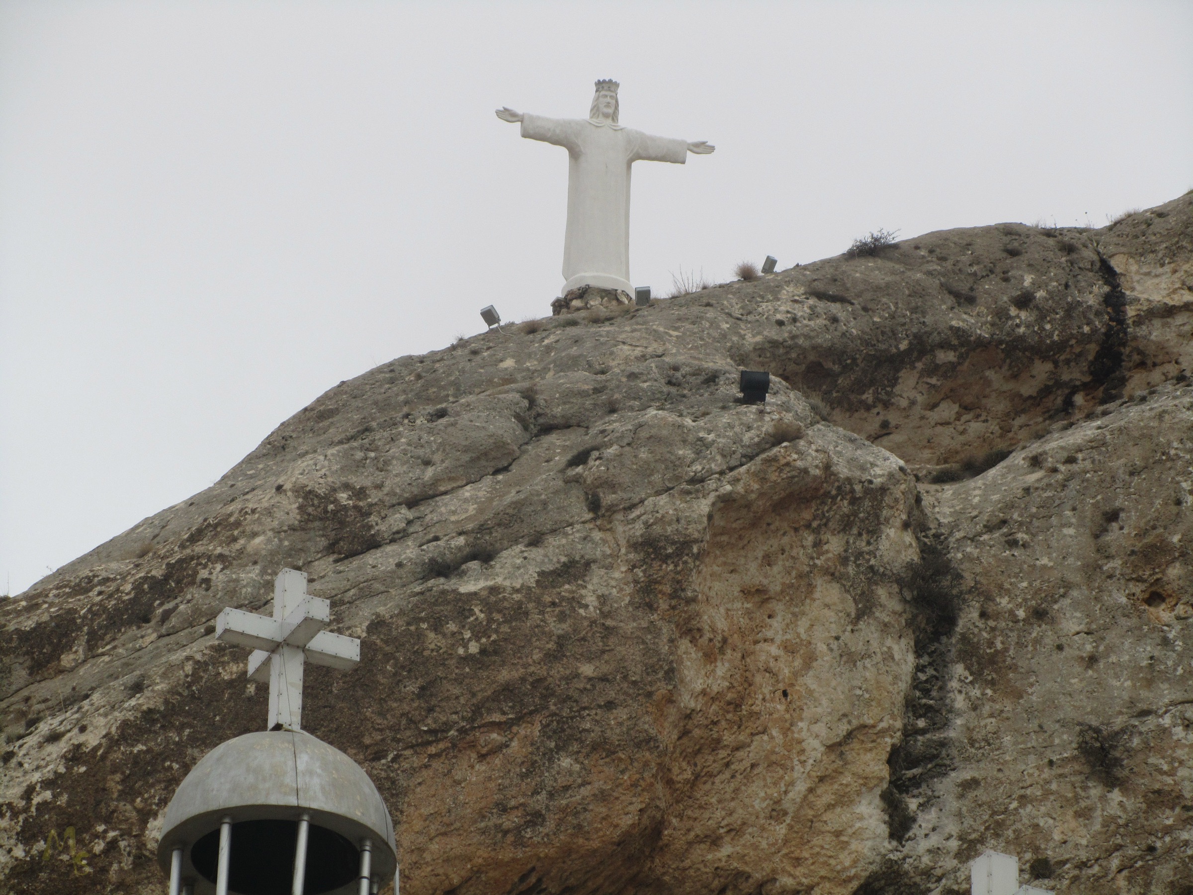
Cristo Rei do Lubango is a 30 m white-marble statue of Christ the King on the southern Serra da Chela ridge directly above Lubango, completed in 1957 by Madeiran settlers and modelled on Rio de Janeiro’s Christ the Redeemer. From the city centre, a sealed access road climbs the wooded south-facing slope of the ridge to a parking area near the statue base; from the upper car park, a short footpath and internal staircase reach the plinth and a small viewing terrace looking back over the city and out across the Humpata Plateau. Many residents and visitors walk the final stretch from a drop-off point lower on the road, giving a useful 3-5 km return outing if started from central Lubango. The terrace is one of the most-cited sunset viewpoints in Angola, and the statue was declared an Angolan World Heritage site by the country’s Ministry of Culture in April 2014.
Why it is essential
Cristo Rei is the cultural anchor of any Huíla Highlands programme — a Portuguese-era devotional monument that is also the most accessible high viewpoint over Lubango, the regional hub. It is one of only a handful of large Christ statues of its kind worldwide and is repeatedly cited as a defining image of the city alongside Tundavala. The walk pairs naturally with a Lubango town visit and works as an easy acclimatisation day before higher-altitude or remoter objectives.
Equipment
Standard hiking equipment: comfortable walking shoes, sun protection, water and a light layer for the cool plateau evenings. No technical kit is required.
Hazards and notes
- Persistent landmine risk in rural Angola; this is an urban-edge walk and the formal access road and statue grounds are safe, but stay on cleared ground rather than wandering into uncleared bush on the southern slopes. Verify HALO Trust district clearance status before any off-trail walking elsewhere in the region.
- No formal mountain-rescue infrastructure in Huíla Province.
- Civil-war-era unexploded ordnance contamination remains a documented hazard in rural Angola.
- Although the Cristo Rei terrace itself has a low parapet, sections of the southern Serra da Chela ridge fall sharply to the south; do not leave the marked grounds. Comparable falls have been documented at the Tundavala escarpment edge a short drive northwest.
- Malarial prophylaxis required below ~1,500 m; the statue at ~2,130 m is at low risk.
- The road approach passes through urban Lubango: usual urban precautions against petty crime apply, and walking after dark is not advised.
GPX / KML links
| Source | URL | Format / access | Reuse status |
|---|---|---|---|
| OpenStreetMap — Cristo Rei do Lubango | openstreetmap.org | Source map / location | OSM data is ODbL; not a route file |
| Wikiloc search — Cristo Rei Lubango | wikiloc.com | Search page | Wikiloc terms apply if a track is later selected; no GPX selected here |
External links
- Wikipedia — Christ the King (Lubango)
- Visit Huíla — Cristo Rei do Lubango
- U.S. Department of State Angola Travel Advisory, 5 March 2026
3. Fenda do Bimbe (Humpata) viewpoint walk
Snapshot
Itinerary
Fenda do Alto Bimbe is one of five named escarpment fissures along the southern Serra da Chela / Humpata Plateau edge and is described by the provincial Visit Huíla portal as one of the principal viewpoints of the Huíla geological park. The Angolan tourism source places it about 32 km from Lubango, with the final access from Humpata village along a track that is reported to require a 4WD even in the dry season. From the road-end, a short walk leads to a rim balcony with views over the Chela escarpment, which falls almost 1,000 m to the Namibe foothills. A second, steeper local trail is described as climbing toward the highest point of the rift; tourism sources caution that conditions should be checked with local inhabitants beforehand. Most visitors return to Humpata by the same route.
Why it is essential
Bimbe is the less-developed sibling of Tundavala — a comparable rim viewpoint on the same Chela escarpment line, with the same dramatic 1,000 m drop but without the paved access, signposted parking area or tourist crowds. It rounds out the rim-walk theme by adding a quieter, more remote escarpment edge and shows the Humpata Plateau’s characteristic mix of savanna, steppe and karst at close quarters.
Equipment
Standard to mountain hiking equipment: sturdy shoes or boots for the rough access track, sun and rain protection, water, food and navigation backup. A 4WD vehicle is reported as essential to reach the road-end, and a local guide arranged in Humpata is strongly recommended for orientation on informal paths.
Hazards and notes
- Persistent landmine risk in rural Huíla and adjacent Namibe Provinces. Stay on existing tracks and on the rim road; verify HALO Trust district clearance status before any off-trail walking.
- Civil-war-era unexploded ordnance contamination remains a documented hazard in the rural Humpata area.
- No formal mountain-rescue infrastructure; evacuation from the escarpment would be slow and improvised.
- Extreme exposure at the Chela escarpment edge; the Bimbe rim, like Tundavala, has no protective railings, and falls from the Tundavala escarpment edge are documented in the regional press. The same precaution applies here.
- Malarial prophylaxis required below ~1,500 m on the escarpment foot; the plateau itself, at ~2,300 m, is at low risk.
- Access track condition is variable; confirm passability with local sources before committing a vehicle.
GPX / KML links
| Source | URL | Format / access | Reuse status |
|---|---|---|---|
| OpenStreetMap — Humpata area | openstreetmap.org | Source map / location | OSM data is ODbL; not a route file |
| Wikiloc search — Fenda do Bimbe / Humpata | wikiloc.com | Search page | Wikiloc terms apply if a track is later selected; no GPX selected here |
External links
- Visit Huíla — Fenda do Alto Bimbe
- Wikipedia — Huíla Plateau
- Wikipedia — Serra da Chela
- U.S. Department of State Angola Travel Advisory, 5 March 2026
4. Huíla plateau dambo walk near Humpata
Snapshot
Itinerary
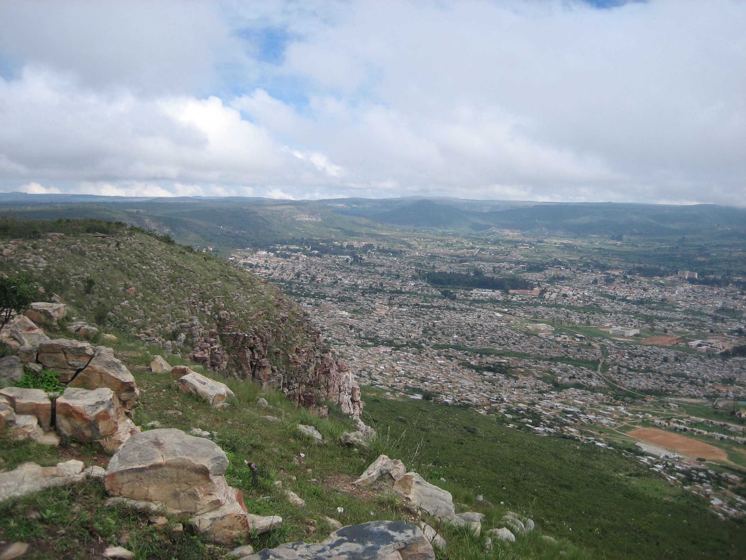
The interior of the Humpata Plateau between Lubango, Humpata and Chibia is a mosaic of cool high-savanna, seasonal dambo (grassland wetland) systems, miombo woodland fragments and dolomitic karst outcrops, sitting broadly between 1,800 m and the 2,300 m high point on the western edge. Local walking routes here are informal: cattle tracks, paths between farms and missionary-era trails that connect the small settlements south and west of Lubango. The walk envisaged in this catalogue is an interior plateau loop on rural tracks, started from a defined point on the Lubango-Humpata-Chibia road and arranged with a local guide. No single, standardised route, distance, or trailhead has been verified in public sources for this catalogue.
Why it is essential
A rim-only programme would miss the surface of the Huíla Plateau itself — the cool, dolomitic karst-savanna country that gives the highlands their character and historic agricultural importance. Including a plateau-interior dambo walk acknowledges that the highlands are more than a viewpoint over a cliff. It also matches the regional tourism description by Africa’s Eden and the Visit Huíla portal of a “highland scenery of green valleys, rugged escarpments and cool mountain air”.
Equipment
Standard hiking equipment: comfortable walking shoes or boots, sun protection, water, food and a map/GPS — the plateau is open and navigation aids are useful in the absence of waymarked trails. A local guide is recommended both for route-finding and for landmine-safety advice on any off-track ground.
Hazards and notes
- Persistent landmine risk in rural Huíla and adjacent Namibe Provinces; the Humpata Plateau interior has had documented contamination, and HALO Trust survey work has been carried out in Huíla. Check HALO Trust district clearance status and seek local advice before any off-track walking.
- Civil-war-era unexploded ordnance contamination remains a documented hazard in rural Angola.
- No formal mountain-rescue infrastructure.
- The Chela escarpment edge runs along the western side of the plateau; navigation errors that drift westward into the escarpment country can become serious. Falls from the Tundavala rim are documented and the rim has no protective railings — keep clear of the western edge unless on a known viewpoint walk.
- Malarial prophylaxis required below ~1,500 m; the plateau itself, at ~1,800-2,300 m, is at lower risk.
- Dambos hold standing water in and just after the rains; cross at established crossings only and watch for bilharzia in slow-moving water.
GPX / KML links
| Source | URL | Format / access | Reuse status |
|---|---|---|---|
| OpenStreetMap — Humpata / Chibia plateau | openstreetmap.org | Source map / location | OSM data is ODbL; not a route file |
| Wikiloc search — Humpata / Lubango plateau | wikiloc.com | Search page | Wikiloc terms apply if a track is later selected; no GPX selected here |
External links
- Wikipedia — Huíla Plateau
- Africa’s Eden — Lubango & Huíla Plateau
- Visit Huíla — destinations index
- U.S. Department of State Angola Travel Advisory, 5 March 2026
5. Serra da Neve approach (Namibe Province)
Snapshot
Itinerary
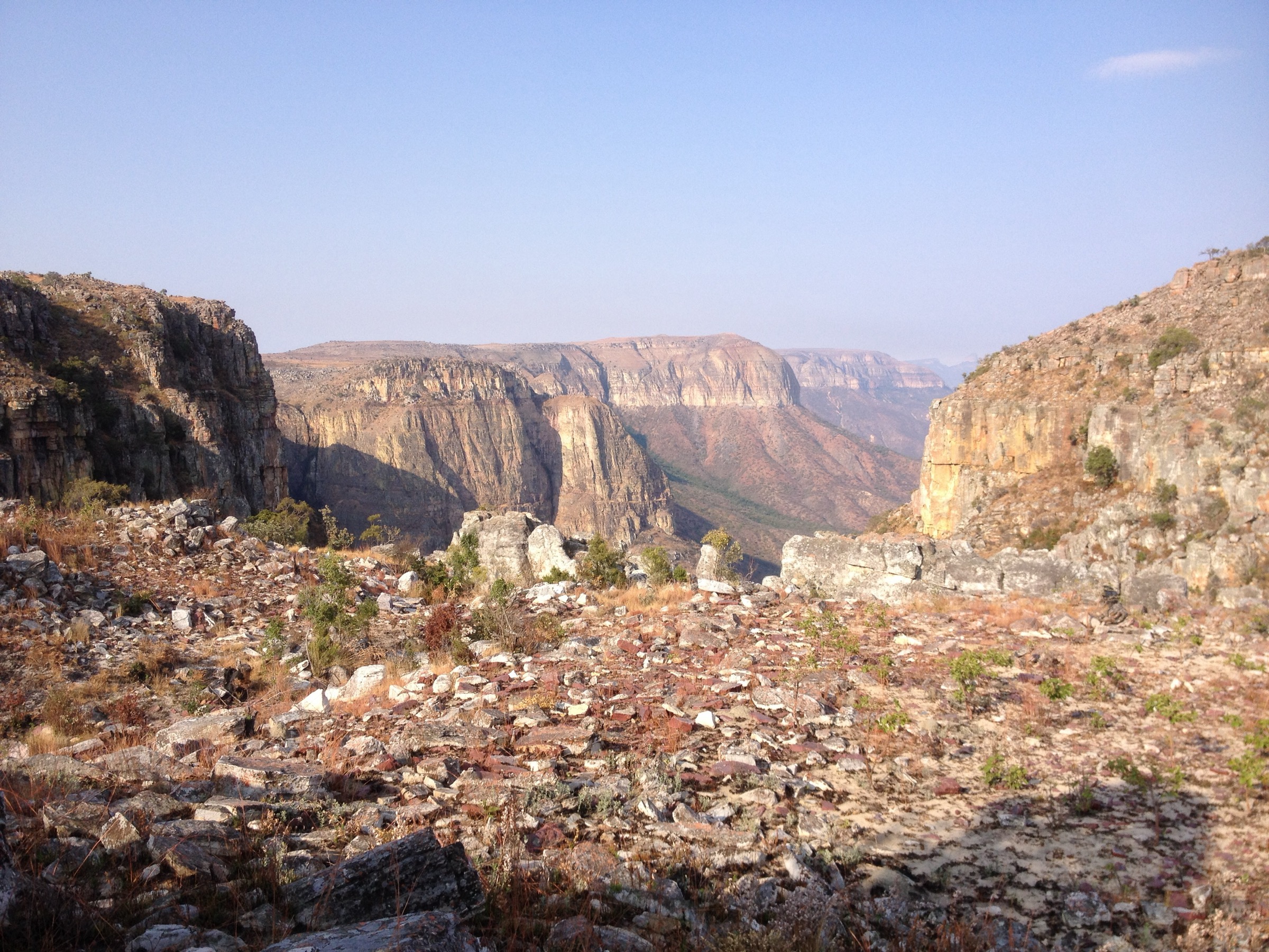
Serra da Neve (“snow range” — though it does not in fact snow there) is an isolated inselberg in Namibe Province, southwestern Angola, repeatedly cited in academic herpetological literature (Ceríaco et al., ZooKeys 2018 and 2024) as Angola’s second-highest peak at about 2,489 m. PeakVisor lists a lower elevation of 2,371 m, and other databases disagree further; the discrepancy is unresolved in this catalogue. The inselberg rises abruptly above the surrounding Namibe lowland, supports a relict mesic vegetation and a striking number of endemic reptiles and amphibians, and is described in the scientific literature as “one of the least-explored regions in the country”. No standardised public day-hike route, trailhead, distance or ascent figure has been verified for this catalogue; the entry is included only as a flag for the highest associated objective of the southern Angolan highlands.
Why it is essential
Even as a candidate, Serra da Neve is included because the southern Angolan highlands have no other comparable verifiable high-summit objective: Mount Moco, the country’s highest peak at 2,620 m, sits in Huambo Province and is catalogued in the central Angolan highlands sibling article. Serra da Neve’s biodiversity profile and second-place altitude ranking justify its presence here as a research target, with the caveats noted.
Equipment
Mountain hiking equipment if a future route is verified: sturdy boots, warm and weatherproof layers, sun protection, plenty of water, food, navigation backup and headtorch for long days. Any attempt requires a local guide and 4WD logistics. Self-evacuation should be assumed.
Hazards and notes
- Persistent landmine risk in rural Namibe and adjacent Huíla Provinces; HALO Trust survey work was flagged for Namibe rather than active clearance, indicating contamination may remain unmapped in places. Check HALO Trust district clearance status before any off-trail walking.
- Civil-war-era unexploded ordnance contamination remains a documented hazard.
- No formal mountain-rescue infrastructure; the inselberg is genuinely remote.
- Extreme exposure on the inselberg cliffs and on the equivalent Chela escarpment edges nearer Lubango; falls from the Tundavala rim are documented and the rim has no protective railings. Approach any cliff edge with caution.
- Malarial prophylaxis required at the inselberg’s base (below ~1,500 m); risk drops on the higher summit plateau.
- Route-finding, water availability and access permission all need local verification before this can be considered a publication-ready route.
GPX / KML links
| Source | URL | Format / access | Reuse status |
|---|---|---|---|
| OpenStreetMap — Serra da Neve | openstreetmap.org | Source map / location | OSM data is ODbL; not a route file |
| PeakVisor — Serra da Neve | peakvisor.com | Mountain profile | Database entry; not a route file |
External links
- Ceríaco et al. — Herpetofauna of the Serra da Neve inselberg (ZooKeys)
- PeakVisor — Serra da Neve
- Ver Angola — Serra da Neve
- U.S. Department of State Angola Travel Advisory, 5 March 2026
Missing data / follow-up work
- Tundavala rim walking statistics are not officially published; route length figures (2-4 km) are approximate estimates based on the layout of the informal rim path network, not a measured trail.
- Cristo Rei do Lubango “from town” route statistics are approximate; the upper-car-park-only approach is much shorter (~10-15 minutes uphill) and the city-to-statue figure depends on the chosen start point.
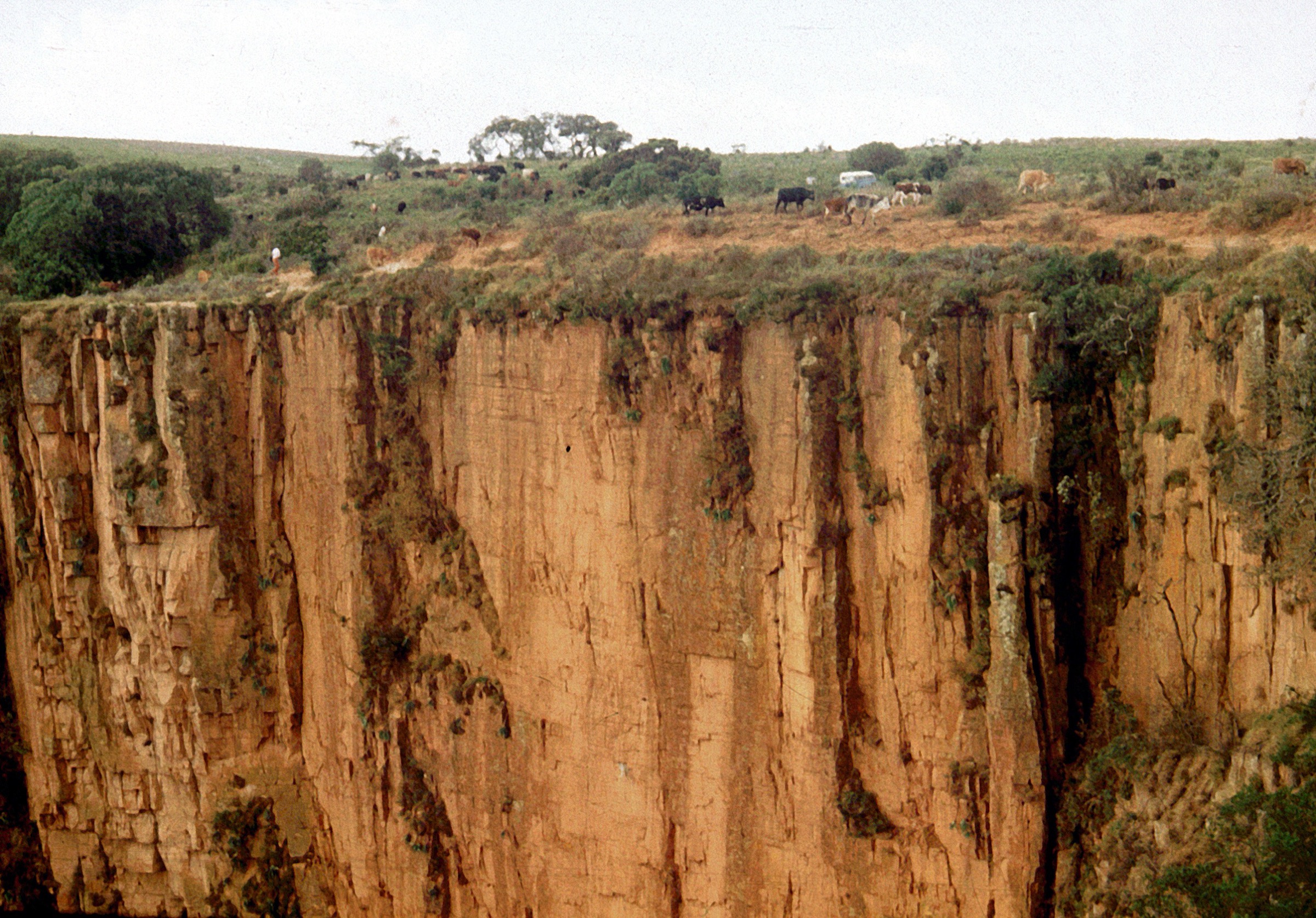
- Fenda do Alto Bimbe walking statistics and trailhead coordinates remain unresolved; only feature, distance from Lubango (~32 km) and elevation (~2,300 m) are corroborated by tourism sources.
- The Huíla plateau dambo walk is a landscape-type recommendation rather than a verified single route; no standardised public day-hike file was located.
- The Serra da Neve approach is a research target only; summit elevation, route, trailhead and access permission all need local verification before publication.
- No licence-compatible image specifically of Fenda do Bimbe was located; a regional Huíla Plateau canyon image is used and explicitly labelled.
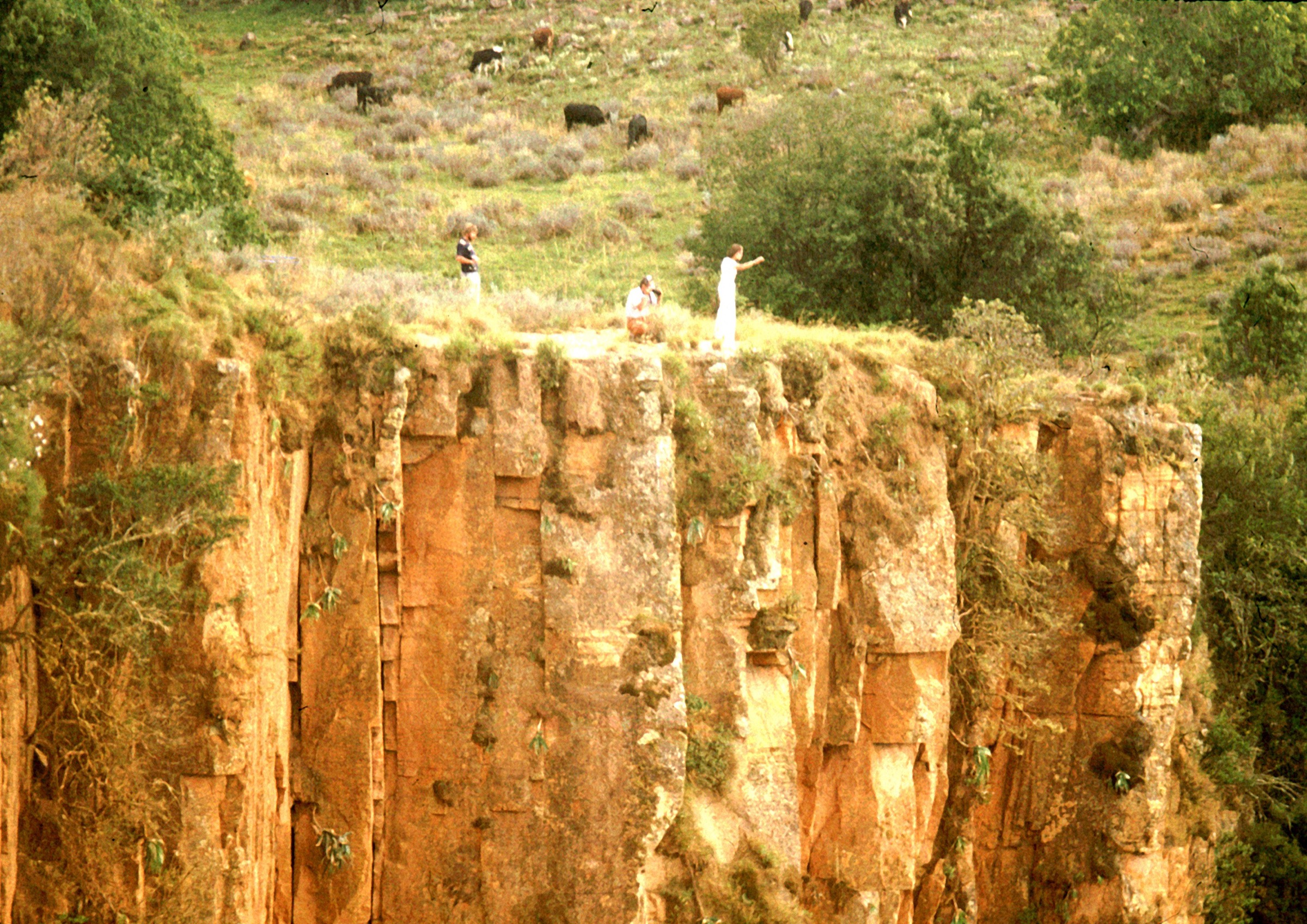
- No licence-compatible image of Serra da Neve at the catalogue’s resolution floor (~2,000 px long edge) was located; the only Wikimedia Commons images by Ceríaco et al. are below that floor. A regional Huíla escarpment image is used and explicitly labelled.
- No official Angolan GPX / KML route files for any Huíla Highlands day-hike were located; OpenStreetMap is the only verified open-data layer.
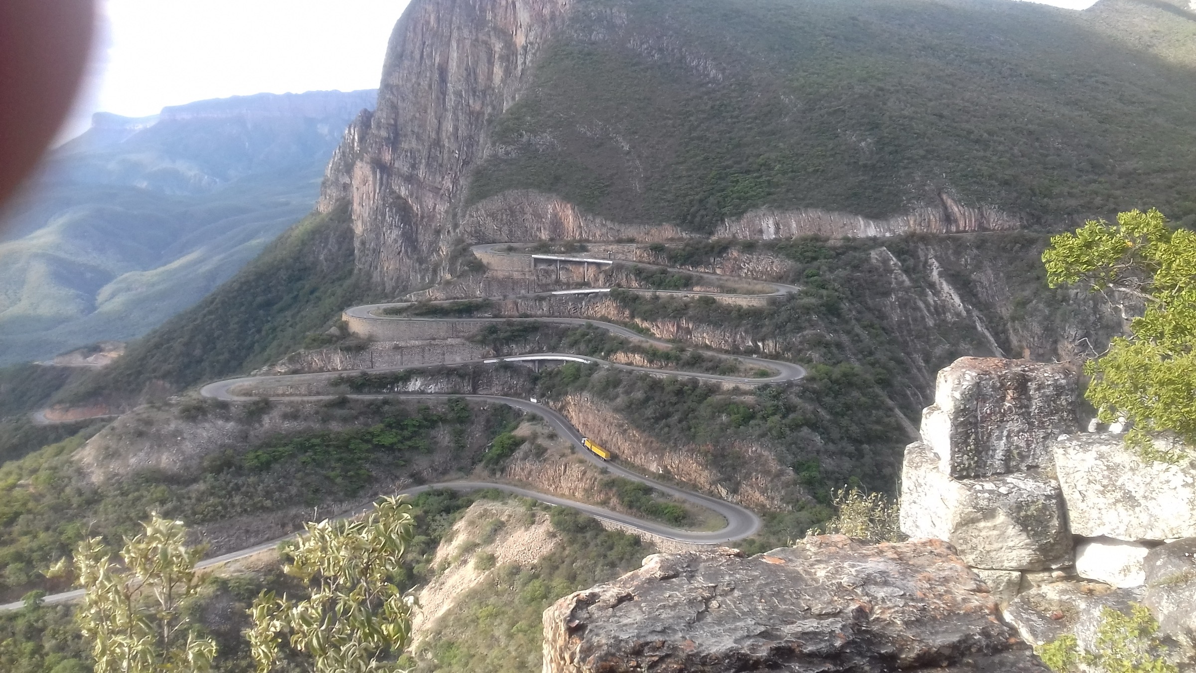
- The Serra da Leba pass and escarpment road are catalogued separately and are intentionally excluded from this entry.
- Mount Moco (central Angolan highlands, 2,620 m) and the Bié Plateau interior are catalogued separately; readers expecting Angola’s highest peak should follow that cross-reference.
- HALO Trust’s most recent published landmine residual estimate (just over 1,000 minefields, ~67 km² remaining as of end 2024) should be cross-checked against current district status before walking off paved roads in Huíla or Namibe Province.
- Angola is under a U.S. Level 2 (“Exercise Increased Caution”) travel advisory as of 5 March 2026; conditions should be re-checked before travel.
External links
| Resource | Link |
|---|---|
| Wikipedia — Tundavala Gap | en.wikipedia.org |
| Wikipedia — Christ the King (Lubango) | en.wikipedia.org |
| Wikipedia — Huíla Plateau | en.wikipedia.org |
| Wikipedia — Serra da Chela | en.wikipedia.org |
| Wikipedia — Lubango | en.wikipedia.org |
| Visit Huíla — Tundavala | visitehuila.com |
| Visit Huíla — Cristo Rei do Lubango | visitehuila.com |
| Visit Huíla — Fenda do Alto Bimbe | visitehuila.com |
| Visit Angola — official portal | visitangola.com |
| Africa’s Eden — Lubango & Huíla Plateau | africaseden.travel |
| Geoheritage of the EN280 Leba Road (MDPI Land 2024) | mdpi.com |
| Ceríaco et al. — Serra da Neve herpetofauna (ZooKeys) | zookeys.pensoft.net |
| PeakVisor — Serra da Neve | peakvisor.com |
| Ver Angola — Serra da Neve | verangola.net |
| HALO Trust — Angola landmine clearance | halotrust.org |
| U.S. Department of State Angola Travel Advisory, 5 March 2026 | travel.state.gov |